Showing posts sorted by relevance for query trails. Sort by date Show all posts

Monday, September 2, 2019

3 trails

We have had several posts looking at places with the Gardner name. One of these is Gardner, KS near which is Gardner Junction which was on the three trails: Santa Fe, Oregon, California. This is unique, to be where the travelers all were at the same place. The research query was in regard to some particular places, but we know that we need to get a more full list (pending).

Recently, we were in the area where the Trails were going toward Gardner. As well, we thought to look at more details (below). This same route was taken by the New England party (men and women) that left via a port in New York and sailed to Chicago before traveling over to St. Louis and west to Kansas City. They got to an area and established Lawrence, KS (Final migration, Lawrence and Kansas).

On looking deeper, we found the 3-Trails Corridor (defunct link). This was funded by a school initiative that looked to be associated with the Lewis and Clark celebration: 3-Trails Village Community Improvement District. We will look at this further. But, here are a couple of maps. One is from our earlier post. The other depicts points along the route.

Gardner, KS
We have had several posts on this theme and will be adding more. It's about time for a summary look which will appear in the next issue of The Gardner Annals, Vol. V, No. 1. The trails played a major role in the western movement. Too, we need to add in the Mormon experience.

As mentioned in an early post, there were to sea routes to California: around the Cape, two  voyages linked by a trek across Central America.

The gist is that this type of detail work is what one expects from a location. Same goes for a family. There may be major overviews, but a lot of the grunt work needs to be done by the family. Dr. Frank showed us one example. We still have lots of work to do.

So, there are several pending bits of work with Gardner Junction which is the southern trek out of the Kansas City area. This route was fine for the folks going to Santa Fe. But, it was out of the way for the California (gold rush) and Oregon trekkers. It went too far south. Young bucks figured out that they could continue north by water to St. Joseph, MO. This area became last stopping point where dry goods and other merchants had supplies at hand. The travelers still had to cross the Missouri river.

As an aside, some earlier posts looked at the trek from New England to Lawrence, KS. The movement was by foot, for the most part, in the last part of the journey. And, there was a river to be forded prior to arriving at Lawrence. So, this was practice for something that would be a continual source of grief all of the way across the country.

Far cry, one might say, from the easy of rushing down the Interstate. BTW, that subject is of interest, too, since many of those merchants were Yankees.

Perspective: From the KC area to Fort Larned (see the Kansas part of the Santa Fe trail - about 2/3 across the State), the experience was a daily grind for three weeks (makes "are we there yet?" which is known from another perspective to be quite tame). At least, at some point, those same persons saw the Sangre de Cristo mountain range. We have a post on that, too.

This image shows the area near Gardner KS where one finds a kiosk with information about the 3 Trails and Gardner Junction.

Remarks: Modified: 06/24/2022

08/07/2020 -- In this post, we are looking at two disparate spots that share a name, however there are many points in-between. Like Eudora, KS. Where "The Wakarusa meets the Kaw" is on their history site and is an example of local lore getting some attention. See "Along the Western Trails."

08/27/2020 -- Removed stale pointer to 3TrailsCorridor which dealt with the portion in MO: The 3-Trails Corridor follows the traveled way of the Santa Fe,  Oregon, and California national historic trails. It extends from Wayne City Landing on the Missouri River in Sugar Creek, Missouri, where the river boats off-loaded onto wagons and pack animals, southwesterly to Gardner Junction in Gardner, Kansas.

06/24/2022 -- Updated links to Eudora's website as topic continues to be of interest: A Ride to Kansas

Tuesday, August 11, 2015

Gardner, KS

Earlier, we looked at places with the Gard[i]ner name. Then, we took Gardiner, OR and wrote about the person for whom the town was named, Henry Dearborn Gardiner (pg 31, v 35, no 1, TEG; pg 6, v II,n I, The Gardner Annals). That same family was the inspiration for Gardiner, ME.

So, talking of Oregon, there is a town on the trails (see next) in Kansas, named Gardner. It may have been named for Henry Joseph Gardner, Governor of Massachusetts (1855-1858) as there were many pioneers from Massachusetts in the area.

First, about the town. It was where three trails split into two: Santa Fe Trail, Oregon/California Trails. The Santa Fe Trail ended up in a city in one of the oldest areas of the U.S. The other two trails were coincident until much further west where the California Trail headed south; after going west out of Gardner for awhile, they headed up to Nebraska then west to what is now called Wyoming.

Now the Gardner was Henry Joseph Gardner who was a descendant of Richard Gardner of Woburn who is on the list provided by Dr. Frank (the Gardners and Gardners post is the most popular all time).

---

The mid-west and central parts of the country are full of displaced New Englanders. A little up the road from Gardner is Lawrence whose main drag is named Massachusetts.

Remarks:  Modified: 06/24/2022

04/02/2016 -- Map showing Gardner Junction and the split of the trails west of Gardner, KS.

08/13/2017 -- Posts on Lawrence (and surrounds): Trails WestWestward HoBlogging and suchFinal MigrationThomas Wentworth HigginsonKansas and Lawrence

10/26/2018 -- Map of Gardner Junction. 


08/07/2020 -- In this post, we are looking at two disparate spots that share a name, however there are many points in-between. Like Eudora, KS. Where "The Wakarusa meets the Kaw" is on their history site and is an example of local lore getting some attention. See "Along the Western Trails."

06/24/2022 -- Updated links to Eudora's website as topic continues to be of interest: A Ride to Kansas

Monday, March 17, 2025

Independence and Kansas City

TL;DR -- Trails were and still are in the sense of leaving tracks on the landscape (several places along the Santa Fe and Oregon Trails. And, now the Interstate Highway system with all of the national, state, and local roads. And, going further, even now dirt roads as tracks. Sometimes converted railroad tracks. 

--

With all that is going on in the world, and in the U.S., it is time to look back at the past. In 2020, we got the opportunity to spend time looking at the interior of the country which is huge. In terms of time, we had a frontier century (post has copy of photo of Lawrence, KS by Gardner). We got to learn about the trails and the cities that cropped up (theme of this post). We determined that there was a lost generation or two (Boone was real; officer in the US Revolution; Longhunter; traipser of land (all the way past KC with time spent in western MO) in the movement that came to fore as we looked at the upcoming 250th of the US under the auspices of the Daughters of the American Revolution. Doing applications for some requires lots of additional work. 

Before 2020, we had looked at the trails and those earlier like Jedediah Strong Smith. Gardner, KS was seen as a hub of traffic and activity. Also, we had looked at both land and sea traffic to the left coast (Old LA and the US - as in Los Angeles, CA - in particular, Bunker Hill West, where the culture went back to New Spain and then through several cultural shifts to the current canyons of high rises).

---

Now, to the theme. We saw a video of a talk about the trails and how they came into Kansas City and left. It was of the first part of which there will be another. We mentioned Gardner, KS where 3 Trails split. The Oregon went over the Wakarusa River into the Lawrence area and then up to Nebraska. Even in that trek, the rigors of getting people and goods across the land was obvious, especially trying to get over waterways which were boons and banes (mostly the latter for many). 

The talk: How Independence & Kansas City Became Trailheads for the Oregon/California/Santa Fe Trails, Part 1. The following image came from the talk. On the map (a modern map showing some roads), Independence, MO (where Pres. Truman came from) is on the upper right. Gardner, KS is on the lower left. 

Indepencence, MO
Gardner, KS

In the top middle, notice Wesport which is on the Missouri River. After a little bit of time, impatient travelers (read, young men off to the coast with gold fever) realized that they could take the river up past St. Joseph, MO (famous for the Pony Express) and then a little further north, they could head west in Nebraska. While doing that, they would meet travelers coming up from Gardner, KS. But, they would have cut several days off the journey. 

OCTA, sponsors of the research and talk

---

Notice that this is about the early times. The railroad came into play after the Civil War. 

Generations? By this time, say before the Civil War, we were to the 8th generation from the start of New England. The Revolution was mostly of the 5th generation

Cultures? As we have noted, there were the News: Spain; France; England; Sweden; ... The left coast allows us to look at the first; Quebec, Canada is representative of the second; we had both a North and and a South for the third; and so forth. 

---

KC? MO and KS. Missouri and Kansas. We need to look at the area a little further. It's known for beef and barbeque. Well, cattle came up from TX to be shipped east to the hungry easterners. Too, the breadbasket founded itself on the rich lands of the area. Boone, as said, was there early. It's sister city in MO, St. Louis, was the administrative and bureaucratic and entertainment hub. See early Missouri, for instance. 

Remarks: Modified: 03/17/2025

03/17/2025 -- 


Thursday, March 3, 2016

Trails west

In 2014, we did some research related to the origins of Gardner, OR. An article in The Essex Genealogist (TEG, v 35, no 2) and The Gardner Annals (TGA, Vol II, No 1) provided details about the ship (barque Bostonian) that wrecked at that site, its owner (Henry D. Gardiner), and some genealogical information. Henry was a descendant of George of Rhode Island, but his wives were descendants of Thomas of Salem.

Prior to the time that the ship left Boston, it had run up and down the east coast and points further. In the same year of the shipwreck, the Bostonian had been New Zealand.

Last year, Philbrick's book about the whaling ship, Essex, that was out of Nantucket, was made into a movie. Recently, I read the book (only saw the preview of the movie). I don't know if the movie went into the cannibalistic events, however they are described in Philbrick's book. This gives one pause or ought to. But, we'll not go further into the subject. The book is exemplary due to its attention to detail plus to its copious notes.

However, there are some humorous notes. Philbrick talked about the loading process that preceded the voyage. Too, the crew had to be put together. Of course, Nantucket'ers were preferred but scarce. So, they had to cast a wide net to get the manpower. As you would expect, many on the crew would be newbies (tenderfoot out west - see below). Philbrick writes about the Captain having to be out on deck during departure so as to direct the crew. And, it sounded like it could be like Keystone Kops. So, embarrassing to the old salt.

You see, everyone on Nantucket would know when a ship was leaving. And, they would all be down to watch the spectacle. Now, a ship in full sail and under control is a sight to behold. Yet, that would not be the case. And, Philbrick wrote about the Captain being aware that those with long-glasses could watch the going-ons for a long while until the ship was out of sight.

The book is a good read.

Now, on another subject, the Bostonian went from Boston to San Francisco in 1849. It left in July and arrived in January 1850. That was the long way to S.F. by sea (if it were the only one open to the flower children, 1967 would not have happened). Another sea method was to go down by ship to Central American, cross over, and then back up the left coast by ship. That required two ships, at least. The journey across Central America was arduous. Also, there were things of concern, such as diseases, thieves, and other perils. Many lost their fortune on the way back after having found success in California's gold mines. Some disappeared.        

Henry D. Gardiner (and, Gardiner, OR)

---

But, there was another way to the west coast: moving oneself over land. Last year, we looked at Gardner, KS. Some say that it got its name from the Governor of Massachusetts (Henry Joseph Gardner - descendant of Richard of Woburn) at the time that a group of New Englanders came to the area. They founded Lawrence, home of KU.

Gardner is not far out of Independence which was the starting point for the trails. They were together until west of Gardner. Then, the Oregon (California) bound wagons went by Lawrence on their way west. The Santa Fe trail headed southwest.

One thing to note is that from Independence, MO to Fort Larned, KS, nowadays, can be done by car in the matter of hours. It is a little less than 300 miles. A lot of it can be done by Interstate Highway. Back in the days, the wagons took three weeks (as in, 21 days) to do that trip. And, it was constant work every day.

On the trails west were Thomas Gardner descendants. Many people stayed at locations that they passed. That was how some cities grew. All along the trails, we find little cities where people decided to stop and grow roots. The advent of the transcontinental railroad (1869 - last spike) saw the same sort of phenomenon.

There was another trail, though. That one was related the western movement of the Mormons from the area of Nauvoo, IL to Utah. Again, many of these travelers were from New England.

---

Why the interest? I have run across several diaries (published) from the time that we can look at in more detail. Many of the diary writers have ties back to New England and its roots. We have had an interest for some time to map out movements west. Some families have described movement to the south, first (Carolinas), before the western thrust.

Too, though, there are always reminders. New Mexico, as a State, was 100 years old just four years ago. It is one of the late comers in terms of statehood. But, it is a very old culture.

Coronado was there and in area of present-day Kansas, in 1541. That was long before there was New England activity. As we get toward the 400th, we will see lots of interest in regard to all of the different places and cultures that make up the current populace's history.  

Remarks: Modified: 06/24/2022

04/02/2016 -- Map showing Gardner Junction and the split of the trails west of Gardner, KS.

06/17/2016 -- More on trails.

07/16/2016 --Gardner's Beacon, Vol. VI, No. 1

08/13/2017 -- Posts on Lawrence (and surrounds): Trails WestWestward HoBlogging and suchFinal MigrationThomas Wentworth HigginsonKansas and Lawrence.

08/07/2020 -- In this post, we are looking at two disparate spots that share a name, however there are many points in-between. Like Eudora, KS. Where "The Wakarusa meets the Kaw" is on their history site and is an example of local lore getting some attention. See "Along the Western Trails."

06/24/2022 -- Updated links to Eudora's website as topic continues to be of interest: A Ride to Kansas


Saturday, March 5, 2016

Gardner Junction

In the last post (Trails west), we looked at ways to get from the East Coast to the West Coast prior to the modern age. Of course, the choices were by land (below) or sea. In terms of the latter, one could cut across Central America or take the long journey around the end of South America. We can show examples of each of these.

Now, the American Indians were in all areas of the country prior to the arrival of the Europeans. Then, there were many mountain men and other explorers around and about. Lewis & Clark was the first organized party sent from the U.S. Spain had already ventured inward from the West Coast and from Mexico. Coronado ended up not far from Gardner Junction.

But, the Trails are, by right, the focus of many as they think of western travel. There were several ways to get to the KC area, but that was the launching point. And, not long after, there was a split at Gardner Junction which is just west of Gardner, KS. This map illustrates how the Trails went after the split.

 
It comes from the National Park Service site which provides three maps plus other graphics related to the subject. One of these deals with the advent of the railroad. With the transcontinental travel via rail being available, the traffic on the Trails ceased.

Remarks: Modified: 04/23/2021

04/02/2016 -- Map showing Gardner Junction and the split of the trails west of Gardner, KS

06/11/2016 -- We have 200th anniversaries coming up.

06/17/2016 -- More on trails

07/16/2016 -- Gardner's Beacon, Vol. VI, No. 1

06/29/2019 -- Example mountain man: Jedediah Strong Smith.

Sunday, December 11, 2022

19th Century details

TL;DR -- Earlier we took a look at transcontinental travel in the early 19th century and its ardors. There was nothing easy about the ordeals, but people took up the gauntlet. Here we look at one site where travelers made their presence known and link to a map that has local details of interest. 

--

We have had several posts on trails. Recently, we looked at a well-known trail (to Santa Fe) as it was the terminus of another trail in New Spain which provided other trails such as that which provided a route used by the Butterfield Overland Mail Company in carrying mail, freight, and passengers from the east coast, through St. Louis and to San Francisco. This was pre-Civil War and was interrupted. Further north, the Pony Express went from St. Joseph, MO to California carrying mail. Butterfield established a new route up north using coaches. Mark Twain wrote of his journey on this route. 

There was another Butterfield in that area who was not related and who had a  Butterfield Overland Dispatch (using a post at the Legends of America site) through Kansas. Both of these Butterfield gents had investors back east. The amount of stations, equipment, horses and people required to have regular routes was tremendous. As we know, the rails of steel were going to play havoc with these routes. But, that was enough later for history to be made. 

As a reminder, at the same time, there was regular traffic from New England which moved south by sail to the area of Panama which involved going across land from ship to ship and then sailing back north. Of course, one could go around South America. We looked at this briefly when writing of the Bostonian (barque) that wrecked along the Oregon coast in 1850. The barque left Boston in July and arrived at San Francisco the following January. It was later seen in New Zealand and, evidently, carried goods to San Francisco before venturing north to its fate. Gardiner, OR resulted from that incident. The overland trails had as many dangers; but, even without those happenstances, the travel was arduous. 

Besides looking further at the specifics of these overland efforts where we find the two Butterfields, we want to bring in more detail as is required for doing history of the events better and for considering the people involved in a more respectful light. Also, the area in the center of the U.S. was very busy. For comparison, we looked at a railroad town and its specifics from the early 1900s (see KATY - western railroad). 

Let's start with a map that comes from KDOT (see 19th Century Kansas Trails). Notice that the Santa Fe and Oregon Trails come into the area in the northeast corner. The Oregon Trail splits off and heads northwest. Another trail in that area is the Butterfield Overland Dispatch which terminated in Denver, CO. The other Butterfield route would have been north of this area. 

Click for detailed 
map from KDOT

The map includes other trails of interest including those used by indigents and that related to the cattle trade where heads were brought as herds to a rail terminus for loading. As one looks at images, the wild west was in this area (see Dodge City). "Hell on the plains" might apply to our few decades of the web. 

Looking at some of the details, there was a military road (double green) that went from Ft. Leavenworth to Ft. Scott and further south. This was there early. We mentioned a Mission in the southeast corner (see Memorial Day 2022). Nathaniel Boone (son of Daniel) was in the area. Col. T.W. Higginson was in Lawrence and Topeka. Lawrence was founded as part of the abolitionists' interest in keeping Kansas free. Take a close look and note a trail (blue dashes) from Leavenworth which was originally for supplying Army posts as they expanded westward but ended up with a California connection

In a recent post, we looked at how Ipswich MA got Ohio going. That was not long after the Revolution and was similar many ways with what happened later out west. In fact, we included a graphic (map) showing both areas. So, we could look at this type of detail across the whole of the region. 

One of our interests is the long reach of New England. Both Butterfields were from New England (their relationship, if any, needs to be researched). For the most part, we will be taking time to link with both genealogical and historical information (see Lorenzo and Peggy). As well, we have a technology interest and want to include specifics of the reality of the earlier times. After all, everyone here had forebears who were alive then. The particulars of the American west are such that we can see the transitions clearly over the frontier century's span. We mentioned it before, but this map brings up the fact: going from the northeast (Kansas City) to Ft. Larned (south central, look for Great Bend) took three weeks of daily work on the Santa Fe Trail. 

One more detail, Jedediah Strong Smith was last seen in the area of Point of Rocks (lower left - southwest). He was killed by an indigent part. 

Remarks: Modified: 12/12/2022

12/11/2022 -- 


Tuesday, November 1, 2016

Final migration

The first would be that covered by NEHGS via its Great Migration Project (pages on Thomas Gardner). We see the 400th anniversaries of these New England areas coming up soon.

At the same time, we can look at the 200th of the great movement west. This is called the final migration as it started to fill in the interior of the country that was shown us, in part, by Lewis and Clark via their expedition. The trails got explored and established. People got off of the trails at various points in order to set down roots. There are several stages to this long bit of history which we will look at.

Right now, and given the current turmoil, we wanted to provide some material about the long reach of New England (a favorite topic). In particular, we will look, in depth, at New England's involvement with what became bleeding Kansas, namely in the period prior to the Civil War (War between the States).

We just found out that a nice presentation of A History of Lawrence Kansas is available on the web. We will use this book a lot. The author, Richard Cordley, D.D., arrived in 1857 and wrote the history in 1895. Below are some excerpts.

To set the stage, let's do a quote. This is from Chapter 1 in which Cordley quotes from Whittier's poem, "Song of the Kansas Emigrant:"
    We cross the prairie as of old
    The fathers crossed the sea,
    To make the West, as they the East,
    The homestead of the free.
---

Remember, the context was after the Kansas-Nebraska bill was passed in 1854. The issue of slavery in new areas was still unresolved. So, New England took it west.


It was decided to establish a presence in the new region. Some had liked, or heard good things about, the area around what was named Mt. Oread. So, several parties were organized.

Now, remember, this is 1854. The trails had now been in use for over 20 years. So, there were modern means available to those who could pay. And, the New England parties were well funded.

After the first party left the Boston area by train, they went to Albany, New York to get Lake Erie passage to Chicago. The next step was traversing land to St. Louis. From STL to Kansas City, they could go by water. Then, they were back to the frontier experience.

"We prepared ourselves at once for starting. An ox team was purchased to transport the baggage and at ten o'clock Saturday evening we started on foot for our destination across the prairie. We traveled as much as possible during the night as the weather was very hot during the middle of the day. We saw occasionally a log house as we passed along, inhabited by farmers, of whom we obtained milk, etc. On the evening of Sunday we encamped on the lands of the Shawnee Indians. On Monday morning we started early, and in the evening arrived at the Wakarusa river, within ten miles of our destination. Here we camped, and the next day reached our new home."

They would have passed through Gardner Junction.

---

Of course, only a couple days of travel is nothing compared to the 1000+ mile trek of the Mormons, yet one has to give these gentle people some credit. They did it on foot.

And, these are all cousins. We'll be looking closer into that. There was one Conant. A lot of other old families were represented.

But, let just quote about their first day.
    This party arrived August 1st. They ate their first meal on the hill where the old University building now stands. Of course they held a "meeting" and "organized." Someone has said that "wherever two or three Yankees are met together there they hold a meeting and organize." The meeting chose Ferdinand Fuller as chairman. They were in good position to

    "View the landscape o'er," 

    which they proceeded to do. They also had some speeches, and discussed the merits of the location and the best methods of procedure. The situation seemed to please them, and they voted to "stay here." They named the bill on which they met "Mount Oread," a name which it bears "unto this day." They remained on the hill a day or two, and then moved down, and camped near the Kansas river a little west of where the bridge now crosses that stream. The members of the party spent several days "claim hunting," and selected claims all around the proposed town site. After this was done, about half the party returned east, with the intention of bringing their families in the spring.
Sound like the Plymouth experience? In fact, the "please them" refers back to Winthrop's early comment on the Boston area after he was turned off by Salem.

There are so many themes to follow in this regard. For one, many of the New Englanders had already settled in states going west, such as Indiana and Illinois. This year, we had the opportunity to look closer at some of these folks. Some families had gone south prior to their westward movement.

Remarks: Modified: 06/24/2022

08/13/2017 -- Posts on Lawrence (and surrounds): Trails West, Westward Ho, Blogging and such, Final Migration, Thomas Wentworth Higginson, Kansas and Lawrence.

12/30/2018 -- The 400ths will be one theme next year.

09/03/2019 -- More on the 3 Trails.

08/07/2020 -- In this post, we are looking at two disparate spots that share a name, however there are many points in-between. Like Eudora, KS. Where "The Wakarusa meets the Kaw" is on their history site and is an example of local lore getting some attention. See "Along the Western Trails."

06/24/2022 -- Updated links to Eudora's website as topic continues to be of interest: A Ride to Kansas

Saturday, June 11, 2016

Westward Ho

We already had the 200th of Lewis and Clark's venture west. They came through near where I was recently and spent three days resting and getting their supplies in order. Kansas created a park at Kaw Point to commemorate the event. Other locales established memorials over the length of the Lewis and Clark trek.

Coming up then, too, will be 200th anniversaries of the great migration to the west.

We will be doing more posts on this for several reasons. For one, a major point in the trek was the split at Gardner Junction where the Sante Fe trail went south and the Oregon trail headed north. For a long while, the Oregon and California trails were the same. Then, out west, some wanted to go to sunny California and the Spanish architecture. Others wanted to go to the gloomy north. 

Go spend some time in Seattle to see what I mean. Nice places, though.

Then, too, plenty of Gardner and related families came through this area venturing either way. We will get stories of these families and their ordeals.

A little further south, there was another set of trails that came out of Arkansas heading west. 

One important thing to remember is that even in this eastern region of Kansas, wagons had a problem fording rivers (say, the Wakarusa). For instance, near Lawrence, they had to dismantle wagons as much as they could in order to get the things down the cliffs and over to the other side. Of course, similar efforts were required for the wagon contents.  

Consider, if you would, what was coming up for these folks as they went further west and experienced the terrain found in present day Wyoming, Utah, Oregon, and, even, Idaho.

Major work. Every day.

Do we ever think of that as we buzz down General Ike's (BTW, a Kansas boy) roadways - our current Interstate system?  

Remarks: Modified: 08/16/2025

06/17/2016 -- More on trails.

07/16/2016 -- Gardner's Beacon, Vol. VI, No. 1

11/01/2016 -- On foot traverse.

08/13/2017 -- Posts on Lawrence (and surrounds): Trails WestWestward HoBlogging and suchFinal MigrationThomas Wentworth HigginsonKansas and Lawrence.

08/16/2025 -- Mentioned this topic in a look at the comparative flow of American Rivers. We will look at this topic further as an example of two roles of rivers: means of transport; barrier as was seen on all of the trails. 

Friday, June 17, 2016

Trails again

These are links to material about the settlement of the colonies and the later western movement that the U.S. saw after the conclusion of the American Revolution and after the jaunt of Lewis and Clark under the auspices of President Jefferson. Lewis and Clark told the people about the large bit of land out west.

One theme of the upcoming issue of Gardner's Beacon deals with the west. The long arm of New England reached across the country.

Many more people went across these trails than came over by boat in the early days. The trip was arduous. Present day cities exist along the trails. Modern roads parallel their ways.

In Kansas and immediate territories, the issues that lead to the U.S.Civil war were being played out as abolitionists left New England and helped found the free state.

Finally, from the genealogical side of history, people populated those cities and places in-between as they dropped off the traversing of the trail to settle down to roost. Many stories abound.

Trails (a mere sampling):
Earlier history (southern New England):
This effort is part of our bibliographical effort.

Remarks: Modified: 03/01/2019

07/16/2016 -- Gardner's Beacon, Vol. VI, No. 1

11/01/2016 -- On foot traverse.

03/01/2019 -- Added image. We're building an index by images for the portal to truth.

Saturday, June 18, 2016

Gardner's Beacon, Vol. VI, No. 1

The current issue of Gardner's Beacon starts to look at upcoming 200th anniversaries. More people went out west through the various trails (Westward Ho) than arrived both in northern New England and its southern counterpart. In those early days, there was motivation to go west. For one, claiming land would keep out settlers from other countries. In that case, there were conflict with the American Indian population and with other countries.

By the time of the end of the long American Revolution, people were ready to go west. Lewis and Clark helped capture the imagination. Families took the long trek to Oregon and California. During the gold rush, many 49ers went out by the trails.

An older trail, to Santa Fe, provided the starting point. But, as more people gathered, there were issues, such as a cholera outbreak, that establish another starting point, present-day St. Joseph, MO. Too, the 49ers were in a hurry and wanted to take some days off the trip.

The story would not be interesting without the people. That launching point for western expansion turned out to be where early conflicts started between pro- and anti-slavery proponents. "Bleeding Kansas" was more than a name.

And, New Englanders were heavily invested in the area, in terms of money and blood and sweat.

Of late, DNA has been put on the plate and will be getting more attention. Lots to discuss.

Charles Sanders Peirce (his father, Benjamin) did some marvelous work without much attention. He died destitute. He was the first to look at abductive approaches (see DNA above). Also, he was probably the best mind of that generation, though Eliot of Harvard did not think much of him.

---

See Vol. VI, No. 1 of Gardner's Beacon for a review of research to date. Sources: Oregon-California Trails Association (Trails, again).

Remarks: Modified: 04/23/2021

06/19/2016 -- Switched to larger font, two pages, and introduction to Charles Sanders Peirce.

Saturday, March 6, 2021

Prior and next

TL;DR -- Opinions always follow a spectra mode. How these look in the aggregate can be a thing of beauty. There is never any nestling around a center point, for long. A recent event (one-sided deal, per usual, via the idiot tube - never had a TV until later in life). Turns out, that someone claiming a lowly mode (poor is me) actually has Ed III in the past. To some, in the U.S., that means something. But, rather than diving into that, we bop over to the Magna Carta which is of interest to more people. Again, though, this is from the English experience. And, during the 2000s, there will be many times for us to consider the document, its meaning, those who were there then, and what happened later over the centuries. 

---

So, a duality of several that we will always see. There are lots of these, such as those things that cause controversy. Such as? The US and UK conflict that seems one-sided, with an American citizen dissing HTMQ. Turns out that the one has a link back to Ed III (we wrote of him earlier). This heritage review was developed by Gary Boyd Roberts and Christopher C. Child of the NEHGS. The page has a link to a graphic which is interesting. On a further note, since the graphic is only of one of her lines, we thought to provide an ahnentafel courtesy of Famous Kin. So, there is a lot to discuss as we will be working with our kin there as the 400ths come up just as did the Plymouth folk the past few years. 

So, the prior? About seven to six years ago, there was much interest in the Magna Carta for which we had post here (John and his friends). That event came and went. HTMQ made several appearances during the festivities. Then, the thing was done but with another round in 2025 to celebrate the involvement of Henry III. For Americans, there is a special interest since it is noted that the related thinking was an influence upon the U.S. Constitution 800 years after the fact. And, there will be many more occurrences as we go through time of looking back at this document. 

So, that is the next, with 2025 being on the horizon already. What does this mean? Well, in the U.S., people can find out their family's connection by looking at gateways who are those who came over with this pedigree in their knapsack (or the equivalent). Of those, some already knew 400 years ago. Some were recently discovered to have a connection. Two examples are Mary (Gye) Maverick and Richard More. She was the wife of a Rev. on Winthrop's fleet whose name is now associated with actions, say like the one alluded to above. Richard More, as a kid, was on the Mayflower with his sisters. He married in Salem and is an in-law. There are many more examples. 

WikiTree has what it calls the Magna Carta Project. Using the gateways, they have Magna Carta Trails which go from the gateway to someone involved in the 1215 activity, as a Surety (see list on this page). One thing the team does is work the Magna Carta Base Camp. They have completed trails for many gateways of which there are several hundreds. They have a bunch that are in the process and some being prepared to be scrutinized. 

Why the interest? These are documented lines when they are done. Where else can one go to find this on-line? For Mary, this is her trail. Notice that her nodes for Bigod are 100% verified. However, therre are other trails. For Richard, his trails are in progress. Lines from both of these are in this graphic. 


So, another reason to show this. It's an example of very good work which is what we expect from Gardner Research when doing comparable types of things. One goal might be to do this for the first three to five generations starting from Thomas and Margaret. 

Remarks: Modified: 03/08/2021

03/07/2021 --  Updated Richard's line to show Bigod. 

03/08/2021 -- Put in the TL;DR, later better than never. 

Thursday, December 2, 2021

U. S. Interior

TL; DR -- Before, we talked of the 100th, 200th, 250th, 300th, and 400th coming forward from Cape Ann. Where the 250th deals with the U. S. start. The 400th involved New England and more. Now, we can talk 400 years ago, 200 years ago, and now. 400? The forebears crossed the sea. 200? The waves of immigrants crossed the prairie and other areas of the U. S. interior. Now? We are all sailing the seas of the cyber and virtual and more due to the computationally-framed new world. 

--

In the latest issue of Gardner's Beacon, which was Vol. XI, No. 1, we mentioned one of our continuing subjects: U. S. Interior. In part, the subject of the U. S. interiors deals with history, however we add in the family aspect with the same intent as groups focused upon historical and genealogical topics (say, the NEHGS). We have called the period of over hundred years in which the interior expanded to be the Frontier Century

While browsing today, we ran across a map that looked interesting which is given below. However, let's take a moment for reflection. The map was in a collection of other images related to why the U. S. has been successful, in the world, which is a debatable subject. There was no attribution, so we used the facilities of Google's image search to find the source for the map. It showed several similar maps, however PInterest had the map and pointed to where it got the map. So, that was nice to see. 

The site is run for teachers. Here is the map which provides a timeline for acquisition as well as some indication of the geography. We have had several posts on this subject which are list below (such as, All that Louisiana brought, which is first on the list).  


The map also was used at a Quiz site. Doing this exercise made us aware of a Wikipedia page that looks at the "Territorial evolution of the United States" and provides an animated map. This reminds us of the Virginia map showing its extent over the first few decades.  

List of posts dealing with the western expansion (as we call it). Part of the discussion and work will be taken by concerns for our relationships with the American Indian
  • All that Louisiana brought (Nov 2020) -- The brown area picked up by Jefferson which included St. Louis. 
  • Sam Dunn (Nov 2021) -- A look at the interior by a Londoner in 1794. 
  • State of Missouri (Jun 2021) -- On the right edge of the brown area which was the HQ, so to speak, of those who were surveying, who were early arrivers (fur trading), or who were just passing through. 
  • Michigan, 200 years ago (Aug 2021) -- The light green area on the right includes the colonies and areas that are close. However, things, such as borders, were still being settled there in the early 1800s giving a chance to practice carving the land in a big-time way. 
  • Rendezvous (Apr 2021) -- The dark green area to the left includes the mountainous regions of the northwest (the real one, not the area around Ohio). 
  • New Spain (Feb 2021) -- Covered most of the region west of the Mississippi. This map includes the major rivers which helped carve the land. Coronado was in the middle of the brown region in the 1540s. 
  • Pre-Civil War, San Antonio TX to San Diego CA (Mar 2021) -- Cutting across the lower part of the U. S. in the early days. Again, for the hearty. 
  • Carving the land (Jul 2021) -- As mentioned, St. Louis was an early sight where the surveyors got started on the great middle. The post includes a color-coded map with discussion. 
  • Department of Interior in MO (Jun 2021) -- One of the earliest departments of the new government. Following the Boone family into MO might be of interest for several reasons. 
  • 3 Trails (Sep 2019) -- St. Louis might have been where the paperwork was shuffled, but those heading west converged on the area around Gardner Junction KS which is west of Independence MO for some time. This is in the middle brown section. 
  • Trails West (Mar 2016) -- The Gold Rush (left coast) was later. While it saw a substantial bit of travel by water (around the Cape or split with a ground jaunt across Panama), there were many who went by the trails. The Bostonian went around and sailed from Jul 1849 to Jan 1850. After a jaunt to New Zealand, it returned and shipwrecked along the OR coast. 
  • Paper Trails (Jun 2021) -- One can follow the Post Offices through time (see maps by year). Looking at the treads related to the points, one can get a sense of the eventual railroads  as well as the modern highway system. 
  • St. Louis MO to San Francisco CA (Jun 2021) -- About eight rough days for the hearty traveler. Post also shows the progress of the establishment of the railroad in three maps. 
  • Jedediah Strong Smith (Jul 2018) -- He mapped out the CA Interstate system on foot and horseback. 
  • Trapper, Trader, Rancher (May 2021) -- The Bent family out of New England eventually got to St. Louis. The father was a surveyor and agent for the government. The son was in MO, KS, CO, OK, and TX (using modern state labels throughout to save the fingers). 
  • Rivers and more (Feb 2021) -- The Mississippi and its feeders cover a lot of the brown and light green areas. In fact, water from eastern PA (and NY) go down to the middle of the country. In the dark green of the upper left, waters come down to the Missouri river. 
  • Oregon or bust (Sep 2021) -- Gardiner OR was founded where a ship of New England ownership wrecked. People went out by the wagon trains. Or, they came in from the Pacific after a long voyage. 
  • New France (Feb 2021) -- The area covered was in the upper U. S. as well as in Canada. 
  • Scholars, in general (Aug 2020) -- Papers and maps on the divides that run north to south along the western edge. 
In conclusion, New England influence by family or other parties is our interest. We can see a good reminder with respect to the founding of Lawrence, KS and the University of Kansas
    To set the stage, let's do a quote. This is from Chapter 1 in which Cordley quotes from Whittier's poem, "Song of the Kansas Emigrant:"
      We cross the prairie as of old
      The fathers crossed the sea,
      To make the West, as they the East,
      The homestead of the free.
So, as the early ones "crossed the sea" 400 years ago, we saw the later ones crossing the prairie, the river, the mountains, and the valleys 200 years ago. 

Nowadays? Flyover country or by car (1300 miles from San Antonio TX to San Diego CA, by Interstate, 22 hours). 

BTW, one other focus is technology, especially computationally framed reality. So, now we are going to be sailing the seas of the cyber and virtual? 

Remarks: Modified: 12/03/2021

12/02/2021 --


Saturday, August 6, 2016

Gardner, CO

Context: Gardners and Gardners.

Two years ago, we received a query about Gardiner, OR. The question was: for whom was the town named? While getting information about the town in Oregon, we went through a list of places in the U.S. with the Gardner (Gardiner) name.

Turned out that Henry D. Gardiner was the namesake of the Oregon town near where his ship (barque Bostonian) wrecked in 1850. This Henry was a descendant of George of Rhode Island.

Lately, I have been following trails west in terms of the long reach of New England (both north and south). Travelers going west who left from Independence all went by Gardner, KS after which the Santa Fe and Oregon Trails split (Gardner Junction).  The town was named for the Governor of Massachusetts, Henry Joseph Gardner. This Henry was a descendant of Richard of Woburn.

Today, we go to the region of the Sangre de Cristo range. This impressive range was visible to those who took the northern part of the Santa Fe Trail. Rather than cut down toward Las Vegas, NM, the travelers went west and joined up with traffic coming south from Denver and other northern points.

On their way south, the wagon went through what is now Walensburg on their way to tackle the Raton Pass. A mere 30 miles or so to the northwest of the Walensburg area, we find Gardner, CO.

The area has a long Spanish history. The Spanish Conquistadors visited. Settlement from the east began in the 1850s. The Post Office had the Gardner name in 1871. The town is named for Herbert Gardner who was the son of Governor Gardner (MA). So, Herbert was a descendant of Richard of Woburn.

The below list is of interesting reads about the area. Some have photos of the area, including a landmark named Gardner Butte.
This site brought together two old cultures. Santa Fe, which is south of Gardner, was the mainstay of northern Mexico from the 1500s. The trails carried travelers from the east on their way west. As such, the trail travelers had covered more miles.

There are a few more Gardner locations in Northern America for us to mention.

Remarks: Modified: 12/03/2019

08/07/2016 -- Gardner, CO is at the entry of the Wet Mountain Valley. Herbert Gardner introduced agriculture into the area early.

12/03/2019 -- Updated link to image of agricultural field.

Tuesday, April 18, 2023

Go West, wrote Horace

TL;DR -- Supposedly, the phrase associated with "Go west" is attributed to Horace Greeley. While researching, we found that Horace had gone west, prior to the Civil War. He did it cross country and wrote of the journey in detail. This information pertains to our current time and issues; as such, it is worthy of our attention. 

--

In an earlier post, we looked at two cousins, one of which was Adolphus Greeley and the other was USN Captain George William Coffin. They met in the Artic as the latter rescued the former who had been stranded with the crew of his Lady Franklin Bay Expedition. 

A generation earlier, we have another name, Horace Greeley who shares ancestors with Adolphus. Too, Horace journeyed west prior to the Civil War. We ran into his correspondence while researching the historic weather of Donner Pass with respect to the California Trail as this topic is part of our interest in the western expansion and the related trails that crossed the vast interior of the country.  

As an aside, this winter's total snowfall will set a new record. 

Before getting into the gist, we provide profiles for Horace (WikiTree, Wikipedia) and Adolphus (WikiTreeWikipedia) Greeley. Also, we provide more information on George William Coffin who was a graduate of the U.S. Naval Academy and served in the U.S. Navy. 

---

Along with information about trails and passes, we ran into an on-line copy of Horace's book on his trip: An Overland Journey from New York to San Francisco (1860). His journey started in New York by rail and boat until he reached St. Joseph, MO. Until others who headed off west on the trails, Horace went down to Kansas for a Republican Convention at Osawatomie, KS. He mentions going through Lawrence which whose settlement was supported by The New England Emigrant Aid Company. The Convention was on the 18th of May in 1859 (Miami County). This chapter of the book was submitted from Atchison, KS on May 15th. 

His book has thirty-four Chapters of which more than ten are on Kansas, the Plains, the Desert, and gold. These will be of interest as we pursue the history of the U.S. and its interior. He heads west out of Denver by jaunting up to Fort Laramie (Chapter 16) and then west to Utah. Several Chapters deal with Salt Lake City and the area. And, he provides several views of California (Chapters 27 to 33). His final Chapter looks at traffic into and out of San Francisco and discusses the need for a railroad. 

In our post, St. Louis MO to San Francisco CA, we describe the route from St. Louis down into Texas and across the southern border to Los Angeles, CA and then up the coast to San Francisco. The 1860 portion (top) of this graphic shows the transportation status when Horace went west. 

Horace Greeley returned by boat. For this book, his last Chapter was posted on the 9th of September of 1859. 

----

Of note, this was no virtual trip. We have to match this effort up with that of the comedic guy (Samuel Clemens), later. As said, we had several posts on this theme (starting with the mountain men). 

----

This story has several points of interest related to our work. This applies even to our current interest in technology and its historical impact, especially as activities of our times may portend to the future. 

Remarks: Modified: 06/14/2023

06/16/2023 -- Added "Horace" to the title. He went himself.  

Thursday, July 25, 2024

Oregon, by land

 TL;DR -- Getting to Oregon, however done, was arduous. Today, we look at the land routes and note that the ordeals are subject of studies and have been for over a century. 

--

Oregon is in the west, nestled above California. They respect their history ought there so preservation of material is a common theme. Recently, the Oregon-California Trails Association had their meeting. 

There were several ways to get to the west coast and Oregon from New England. We covered the water route in several posts and articles: The Gardiner that was (2018). Gardiner's barque left Boston in July of 1849 and got to San Francisco in January of 1850. It had passengers and sold its freight at the harbor. There was a subsequent voyage to New Zealand. In October of 1850, the barque (Bostonian) wrecked along the Oregon Coast. 

Family members went out another route which was descent to Panama, getting across to the Pacific, and taking another ship north. The return trip was as arduous. We'll look at that further at some point. 

We have written a lot about the land route. As, for a while, the trail went through Gardner, KS (3 Trails, 2019) where it split with the Santa Fe Trail. Over time, as people got familiar with the Kansas City area, they ventured north on the Missouri River to where they could cut out KS and go through NE. This saved a few days. 

Young bucks in high fever were in a hurry to get to the gold field. 

On the journey through Nebraska, the traffic went by Scotts Bluff (Facebook). For now, we put in a photo of the new and the old way which is apropos. People still ride the trail; one of the east-west Interstate Highways runs through the area. So, a brief nod to technology. 

Eagle Rock and a solar car, 2022

Now, let's go further west and look at another split. In Wyoming, the US Government sponsored work to shorten the trip to California. Lander Road was the cutoff that was made. This bypass saved 60 miles for those going to California via the southern route through Idaho. 

Lots of trails crossed the countrry. We appreciate that folks keep up attention on these routes and work to preserve the historical aspects. We expect that the coming 250th of the country will see a surge of interest. At the same time, we need to keep technology on the beneficial side of things, especially with regard to its potential for aiding historical work. 

Remarks: Modified: 07/25/2024

07/25/2024 --    

Thursday, June 17, 2021

Paper Trails

TL;DR -- The Economist reviewed a book that reported on research using Post Offices as a proxy for studying population and movement. The demo and its code for the project is at GitHub with Harvard providing the data repository. This is an example of a growing trend related to reproducibility through time and across region. We look at maps that show the early start and the frontier century. We will revisit the theme as we dive further into research which will also look at nautical world as well as influences other than New England. 

--

We have followed New England's influence starting with the nautical experiences and then getting into the frontier times in the west. St. Louis will be a center point for the earlier part of the westward movement since it was involved in carving up (see Bent post on surveyor father and his trapper son) the huge pieces that were obtained via the Louisiana Purchase and later acquisitions. But, there was movement inward from the left coast, too, as well as from the south (giving us Texas, the great State) and its spheres. 

So, our research focus will include, then, four centers with Salem in the east (yes, we see Winthrop as a later arrival), St. Louis in the center, San Francisco out on the left coast, and somewhere in TX as a southern point. Perhaps, San Antonio. Too, rather than the esteemed heights of the historian (academic) as the focus, we are following families, especially in regard to the middle not being flyover country

The below is motivated by an article in The Economist (How the West was won). So, there is an aura (per usual, Brits, what else?) of judgment that seemed to waft from what the verbiage expressed. Okay, we like the mag, for depth of content and humor. Also, they are talking of a book, same title as the post. Here are some links related to the book and author. 

Now, with respect to GitHub, we have referenced this several times as it pertains to the work of Gardner Research and to the notions of the digital realm (for which we propose truth engineering as a necessity). Our portal (https://TGSOC.org) is a start on the long trek required. Expect the theme to continue. 

Before going further, we want to remind everyone of the Age of Colonialism. The U.S. did not run around the world competing with Europe. Rather, we had our own internal dynamics. The look at the carving of part of the hemisphere will cover that. The nautical? Ah, business on and enabled by the sea. Boston got its Brahmins. The left coast and Texas? We'll punt that to later posts. 

We did snap of Professor Blevin's graphic at dates that are pertinent to our work. We are diving, now, into the situation at the beginning of the wild west, and a little before as we recognize New France and New Spain. We want to go to about the 1850s where the middle was being used as a cultural battleground long before the Civil War. But, the graphic also includes the beginning (1792) and a couple of snaps from the 20th century. 

This page gives details about the analysis using Post Offices. The image below was created from snaps from that page. Note: the application is hosted at GitHub. 

This is only an introductory look. At the top is 1792 when the new country was getting its legs. There is a little dot out west marked by a red arrow (New Orleans? Too early; looks more like TX and too early; so stray dot?). The next row is our current interest which involves the early surveying times (1805) and the time of regular traffic via the trails (1855). The next row is our Frontier Century snap (1811-1921). Why 1811-1921? The snap was after a stop. The years are close enough for what we are doing now. After all, 1811 is one year before 1812's turmoil. 1921 is after both WWI and the Spanish Flu. Lots happened to families between that time. 

We will get more fine-grained later. Lots to discuss there. In the last row is 1990 which is interesting when compared to the 1921 snap. As one watches the graphic, dark regions become light as POs close for any number of reasons. The thing is that the highways become visible. 

Aside, Jedediah Strong Smith gets little respect for mapping out the CA Interstates ;>). He got us aware of the long reach of New England. But, too, he was around a whole lot of other folk that we have looked at and will continue to study. 

Remarks: Modified: 06/17/2021

06/17/2021 -- Added the TL;DR. 

Friday, August 7, 2020

Cumberland Pass

TL;DR - East and west has to be our scope; that is, the totality of the American experience over the four centuries.  Oh yes, a mountain named Harvard. It's in an out-of-the-way place but close enough to Cumberland Pass, in the Rockies. There is another pass in the east through Cumberland Gap. Some went through the eastern pass on the way west; in those days, the travelers would have skirted those higher area as the travel was hard enough without needing extra thrills thrown in, as we see now with technology providing the facility for frivolity.

--

This is a little diversion, related to western movement:
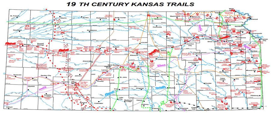
 3 trails, Final migration, and more. We have two passes out of many that those migrating west had to handle with a similar name: Cumberland Gap and Cumberland Pass. The former was a training pass out of North Carolina, associated with Daniel Boone leading people west. He ended up in Missouri, early. The latter represents much higher elevations (11k more feet). Fortunately, even out west, there were choices found that alleviated some of the agony of the work required in those days. One consequence of moving was that record keeping, many times, lagged seriously leaving gaps, many times filled with effort but also becoming brick walls.

We wrote of Cumberland Gap, earlier. The pass through this gap allowed movement toward Tennessee and Kentucky and then all points west. Even with a height of a mere several hundreds of feet, traversing the gap would have required arduous work. The use of 'training' suggests that anyone starting out with this pass on the way to Oregon still had lots work to accomplish of a type of daily grind.

Also, quoting Wikipedia:
  • The passage created by Cumberland Gap was well traveled by American Indians long before the arrival of European-American settlers. The passage through the gap was originally created by herds of woodland buffalo that traveled across it over thousands of years, drawn by the abundance of salt in the region. The earliest written account of Cumberland Gap dates to the 1670s, by Abraham Wood of Virginia.
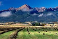
Now, the other pass? It's in the Rockies, in Colorado's Gunnison County, to be specific. Now, this pass was not on any of the major trails that were heavily used. For the most part, there were easier passes (comparatively, to each other, but still requiring hard work, endurance, and carefulness) for those who were heavily laden. Taking a look at passes on the Oregon Trail will give some idea of this.

Cumberland Pass is in the Sawatch RangeTincup CO is on one side of the pass; on the other side is Pitkin CO. Both of these are mining towns which is a type of pioneering effort. For the past few months, we have been looking at pioneer families which is why Cumberland Gap was mentioned. Then, we remembered the other Cumberland pass. Both are named for Prince William, Duke of Cumberland. Both too show the influence of England and New England.

For instance, Mt. Harvard is in this range which includes several mountains that are over 14k feet in height. One interest in this area is that it pinpoints the Continental Divide. As the map shows, with the Mississippi's drainage, we had people leaving the right side, heading to the left. Not only were there rivers to cross, each had many tributaries of various sizes.

So, this pass in Colorado is near where the flow changes. We will have a little more to say about rivers. We mentioned Gardner River which goes to the Pacific. This is further west and north of Cumberland Pass where the Snake (Columbia) and the Gardner River (Missouri) start, ending up in two different places.

The watershed of the
Mississippi River
cut the land through
which the pioneers
had to travel.
With regard to the 'training pass' mentioned above, we noted in a post (Final migration) the report of the group who left Massachusetts and traveled to Kansas. They founded Lawrence (and KU) among other things. But, they mention coming out of the Kansas City area on foot, camping by the Wakarusa, fording it and getting to what became Lawrence. As has been noted, this little river required techniques that became handy in the western mountains: tear down the wagon, lower, get it across, and back up, reassemble, gather everything that had been ported across. Time and again.

This map is to suggest how many times that sort of thing would have been necessary. And, storms, snow run-off, and such would have made crossing turbulent waters part of the concern. So, no interstates and air-conditioned cars. Too, follow the North & South Carolina line to Oregon (lower right to upper left - almost diagonal).   

Note: In the movement west, official recordings always trailed (lagged behind) the edge of the wave. How long this happened varied? There are lists that show when each location started to get regular in recording but that as elastic, too. Never did it just pop into place overnight. There would have been a transition period. So, genealogists with their lead feet? Oh yes, they like to talk as if their need for a document gives being to the ancestors of people who might have, now, holes in their paper trail. Guess what? That is categorically stupid (even Bayes would agree with that). So, what to do? Get more clever about filling in the pieces. Do this without due diligence? No, just stay out of the way and let the story be told as it is pieced together.

Remarks: Modified: 06/24/2022

08/07/2020 -- In this post, we are looking at two disparate spots that share a name, however there are many points in-between. Like Eudora, KS. Where "The Wakarusa meets the Kaw" is on their history site and is an example of local lore getting some attention. See "Along the Western Trails."

08/08/2020 -- Cumberland Pass in the west has the same name as that in the east known as the Gap. However, they represent the movement across the country which established the country. So many stories. Too, they created instances like poor Chloe being dissed by Plymouth people squatted in eastern Massachusetts. It's a large country out here, folks. So, I have now seen oodles of families with the same problem from the tip (Canadian border) all the way to the lower part of Texas. Has anyone really awakened to this? Not that I can see, otherwise I would not have the need for this type of post (Genealogy and Bayes).

08/08/2020 -- Following up on the theme of the difficulty of the cross-country trip, here is another view which is the Google-planned trip from North Carolina to Oregon. The little insert is a map of the Oregon trail which went through Gardner, KS. Later, the travelers went up the Missouri to where Omaha is and then ventured west meeting up with those who came out of Independence, MO.

Modern route,
courtesy of Google Maps
It is interesting how the modern highway system matches up with that the people settled on guided by those who had traveled trail. Reminds us of Jedediah's mapping of the California Interstate System.

08/28/2020 -- Having been researching some of the families of the frontier, it looks as if we ought to pick some as archetypal. For now, let's use Boone and Pike.

02/27/2021 -- Changed to using American Indian. 

06/24/2022 -- Updated links to Eudora's website as topic continues to be of interest: A Ride to Kansas