Showing posts sorted by relevance for query rivers. Sort by date Show all posts

Saturday, August 16, 2025

American rivers, flow

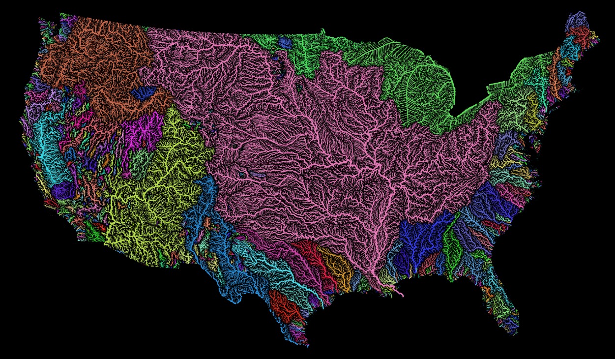
TL;DR -- We saw a graphic while browsing that was not attributed. So, we went looking and found something similar. It shows the comparative flow of the major rivers. The Ohio River stands out as does the Mississippi River which it feeds. Rivers in the southwest are drier by nature. But. they have lots of people drawing off of them. 

--

Rivers are a favorite subject. We enjoy them many ways. Some are famous. Others seem to have disappeared. And example is the Arkansas River that comes out of the Rockies of CO and crosses several US States before joining the Mississippi in AR. Along the way though, if one searches for the river it seems to have disappeared. But, the flow went underground and reemerges sufficiently to support barge traffic from Tulsa, OK to New Orleans, LA. 

On the other hand, the mighty Colorado River comes out of another part of the Rockies in CO and heads down to the Gulf of California. But, along the way, it is dammed (for Lakes) and tapped for people and crops. By the time it gets to Mexico, it is a small portion of itself. 

Those are two western examples. Looking east, the Mississippi gets a large flow from the Ohio River after it has joined with the Missouri River near St. Louis, MO. Lewis & Clark was on both. They took the Ohio down to the Mississippi, then ventured north to travel up the Missouri River, to its source. In doing so, they also looked at some of the rivers of the northwestern part of the US.

What motivated this post was seeing a graphic and looking to see its source. We show the graphic below. At the same time, we looked at some of our earlier posts as they presented graphics too. Let's list a few of these and then add in a new graphic. Each post has a graphic with respect to US rivers. 

  • Continental divides (Feb 2025) -- we think of the Divide that we cross as we travel east-west in the western part of the U.S. But, there are other divides. 
  • New Missouri (Aug 2022) -- when one compares the upper Mississippi to the Missouri, the question about naming comes up. This was really the Missouri River which contributes more water from a longer route. Whereas the flow from the north is shorter and looks larger. 
  • East meets West (Jun 2022) -- the Gardner River flooded and got our interest. It flows through what is known as Gardiner, MT. The map shows all of the watershed of the continental U.S. 
  • Research notes: Rivers (Feb 2021) -- looks at some western rivers (Yellowstone, Gardner, ...) in an area where water goes either east or west.  
  • Rivers and more (Feb 2021) -- looks at the Mississippi and one link from the west to the east via the Fox River.  
  • How great? (Feb 2023) -- looks at a couple of elevation maps of the U.S. This is to put the below material into perspective.  

We started really looking at rivers during the time of the pandemic. We were doing a lot of research which involved families who came west after the time of the U.S. start. This relates to the 250th anniversary of the birth of the Nation. Then, as we researched, more and more information became pertinent. This work precipitated our use of Frontier century and Lost generation

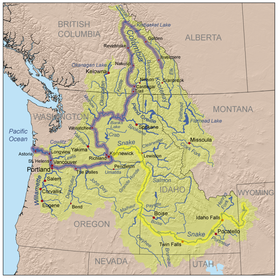
First, let's put up the graphic which shows the comparative flow of watersheds that reach a certain rate of flow. Some of these show up with a light color since the flow is reduced severely as the water makes its way out of the mountains to the shore. 

American rivers
Pacific Institute

In the middle, one sees the long reach of New England with the Ohio coming down to the Mississippi. So, stepping back, one can see the importance of the use of the Ohio in movement to the west. Wagons were brought west, moved north on the Mississippi, and then went up the Missouri. At that point, the wagons went west by land with rivers to cross. That shows rivers in two roles: means of motion; barrier to progress. We looked at the second one in our look at the New England party that left Boston and journeyed to Lawrence KS for two reasons: define a State; start a University. 

Remarks: Modified: 08/15/2025

08/15/2025 - 


Saturday, February 15, 2025

Continental divides

TL;DR -- We look at rivers, again, as they are influenced by divides. East-west interstate highways in the U.S. cross a continential divide, many times with no clear demarcations. However, Montana and Wyoming have a couple of examples that illustrate the natural phenomena. A major Double Divides gets water going west to the Columbia through the Snake River. A Triple Divide gets water going to the Columbia through the Clark Fork River. Both divides feed toward the east and the Missouri/Mississippi watershed. The Double Divide does so via the Yellowstone. The Triple Divide? One flow is through the Marias River to the Missouri. However, there is a third divide that goes east above and below the Canadian Border all the way to Hudson Bay and further east. All of this relates to people moving west from New England after the Revolution. Or later arrivals through various means populating the west. 

--

During our research for the Daughters of the American Revolution. with respect to families who came west, we looked at rivers. We had knowledge of rivers being used for transport which is common, as Lewis & Clark passed close to where we are having come down the Ohio, to the Mississippi, then up to the Missouri and west. That was after the Revolution which is being recognized starting this year: 250th

On the other hand, rivers were barriers to travel (Rivers and more). Progress in technology provided means to manage the difficuly with bridges or tunnels. Too, there has been regular barge traffic for material using rivers. In the early, the travelers dealt with the situations as needed using time and energy. The group that left Massachusetts and went west to start Lawrence, KS and the University of Kansas went up to New York to take Great Lake travel to Chicago. After getting to Kansas City by water and coach, they walked to Lawrence which required that they get over the Wakarusa river
  • With regard to the 'training pass' mentioned above, we noted in a post (Final migration) the report of the group who left Massachusetts and traveled to Kansas. They founded Lawrence (and KU) among other things. But, they mention coming out of the Kansas City area on foot, camping by the Wakarusa, fording it and getting to what became Lawrence. As has been noted, this little river required techniques that became handy in the western mountains: tear down the wagon, lower, get it across, and back up, reassemble, gather everything that had been ported across. Time and again. (see post, Cumberland Pass). 
Here are some of the posts on rivers:
---

The other day, we saw something about a divide in North Dakota (ND). What? That was after running into a mention of a "Triple Divide" (Wikipedia). This mention was on a report by the National Park Service which was of interest as one of the rivers (Marias) from that divide flows into the Missouri River in Montana (MT). The Yellowstone River flows into the Missouri in ND. The Missouri River then flows down to the Mississippi River. We had looked at that area (Gardner River; Yellowstone, Plus). 

Now, having traveled the west by car, train, bus and plane for years, we have gone over a north-west Continental Divide many times on lots of highways and routes. Those divides were always west of ND. All along this western divide, water on one side goes to the Pacific Ocean and on the other side there is a longer flow to the Atlantic Ocean. The map shown here on the left is of a pass (Two Ocean Pass) in Montana (MT) where one creek divides into two; the page on Wikipedia includes a photo of the area where the bifurcation happens. 

So, going back to the mention to ND, the divide (green in the map on the right) starts in MT (at the Triple divide), goes into Canada, comes back down and then goes back up to Canada after traversing ND and Minnesota and heads for the Hudson Bay which flows into the Laborador Sea which can be considered a source for the Atlantic Ocean. This is the Laurentine Divide (starts in the US, goes north, comes back, and the goes up again). We will have to look further at that. Water from Fargo, ND flows north due to this Divide. 

We mentioned the Pacific? In the Yellowstone area, some water runs to the Atlantic, as we saw. On the other hand, though, some water goes to the Snake River and then to the Columbia while picking up tributaries from Idaho, Nevada, Oregon and Washington. A major tributary of the Snake is the Salmon River

And from the Triple Divide that we looked at above, water comes into the Columbia through the Clark Fork and the Pend Oreille Rivers. 

Columbia and Snake Rivers

Remarks: Modified: 02/15/2025

02/15/2025 -- 

Friday, February 26, 2021

Research notes: Rivers

TL;DR -- The rivers of Yellowstone are featured. Too, there is a map of the water basins of the U.S. showing the large size of the Mississippi River and all of its inflowers. 

---

After focusing on the east coast as we got ourselves familiar with the Cape Ann venture, we started to follow western movements which had an early start that accelerated after the U.S. was formed. That change of scope led to us looking across the whole country to the west coast where people could have arrived by one of two ways, by water or by land. 

There are many maritime associations in New England to consider. Example posts are Gardner-Pingree house, The Gardiner that wasWhaling Gardners, and others. With Dr. Frank's TMM, we got acquainted with the long reach west of New England after the Revolution. However, going back in time, one sees the need to look at New France and New Spain. In particular, there was activity related to the fur trade that is within our scope; with that, we get into land movement and rivers. The major waterways were those of the Mississippi which cover the continent from Pennsylvania to Idaho. The former has ports; the latter is next to states with ports. In the below map, the Mississippi basin is colored pink. 

See Grasshopper Geography 

The following pertains to the upper left part of the pink area which is Wyoming and Montana. For reference, Gardner River starts in that region, flows into the Yellowstone River which joins the Missouri River in its long journey to the Mississippi. This area was a major playground for the trappers. 

Fur trading started early in the east (New England and New France) as traders bought furs from the American Indians. But, there was more demand than the American Indians could, or wanted, to provide. Hence, in the early part of the 1800s, we see the fur companies having their own trappers which changed the dynamic quite a bit. As well, we have events which gave stories (such as The Revenant or Grizzly Adams). 

There are many rivers in the Yellowstone basin with a lot more to look at; in the meantime, let's just consider some detail. There are two major rivers from the same location but going to the Missouri in two different directions. 

In this area of interesting rivers, we have a couple more. 

  • Lewis River, flows into the Snake River that goes to the Columbia River and the Pacific. This area is colored orange in the upper left of the map. 
  • Green River, flows into the Colorado River, then to the Gulf of California. This river basin is colored yellow in the lower center of the map. 

With respect to nearness, one motivation for relooking at the western rivers was learning of the portage of two-plus miles between the Fox River and the Mississippi that Joliet and Marquette took in their trek for New France. Essentially, they went from the Great Lakes almost to the end of the Mississippi River.

With regard to the Yellowstone area, the sources for these rivers are close in crow-flying terms (assuming they could get that high). Too, the comparison looks at the sources of the feeders/tributaries. So, taking the Lewis which goes to the Snake, at one point the waterways are with two miles of each other when looking at the boundaries of the Shoshone Lake (Lewis River) and the Yellowstone Lake. That is due to the width of the lakes. A comparison of the inlet positions shows the delta to be less than ten miles. 

However, travel between these two would be arduous, at best, and nearly death-defying in others. That is, before helicopters allowed types of leapfrogging not known to the trappers. The America Indians were in that area a lot, making use of what the valleys offered.  

---

Actually, we are remiss in not looking at the eastern part of the Mississippi system. Let's start with West Virginia which was part of Virginia until the Civil War. This list of rivers shows that most of the State's waterways drain into the Ohio which took lots of traffic west. Joliet and Marquette blew right by the Ohio's inlet to the Mississippi, but they were coming from New France. The other destination for the waters of West Virginia? The Chesapeake Bay, with  most of it going through DC's Potomac River which President George Washington was very familiar with. 

Remarks: Modified: 05/15/2021

02/27/2021 -- Changed to using American Indians. Added the TL;DR line. 

05/15/2021 -- Added link to later post that mentions The Revenant. 

Monday, February 15, 2021

Rivers and more

TL;DR -- Further look at the Mississippi and the portage area in Wisconsin that links the Fox River with the Wisconsin River. 

---

As mentioned before, rivers facilitate travel, however they are also barriers to movement. People moving west out of the east coast traversed large chunks of land as well as crossed over major rivers: All that Louisiana brought. That post looked at the Mississippi watershed which covers almost the whole of the continent, as the river came to the U.S. from the area of New France. Getting familiar with specifics reminded us that we need to look at the other colonies. There were New France, New Spain, New Netherland, and New Sweden. The last two were short-lived, albeit the effects of that effort remain visible until today. It was England, France, and Spain who continued in their conflicts for another century plus. 

Before getting to the theme of the post, let's use a better image from Wikipedia that shows the major tributaries of the most major of the water systems in the U.S. This post deals with an area in the north central of this map (that is, to the upper right of the heavy blue line). Later, we will back up and update an earlier post about the Gardner River which is in the upper left (Yellowstone area). To be complete, we have to look at the other major systems in the west that do not drain into the Mississippi (Columbia, Rio Grande, Colorado, and few smaller systems in the west, plus Texas and its rivers - Pecos and all). 

Mississippi River

So, the theme continues to be about rivers. The Wisconsin and the Fox rivers are so close in Wisconsin (see upper center part of the above map, to the right - the Wisconsin is shown) that a portage was established way back in the 1600s (of course, known way before the Europeans arrived at the scene) that allowed travelers (their original location was the St. Lawrence area) to use the Great Lakes to get to the Fox River (via Lake Michigan) and over to the Wisconsin River so as to get to the Mississippi and venture south toward the Gulf of Mexico. That party traveled down past the Missouri River to the Arkansas River which are both carriers of water from the Rockies. 

What was interesting to learn was the height differences from Lake Michigan to the Mississippi Valley plus the short distance of the portage which was less than three miles. The graphic depicts the elevation of the locks that were established to allow transportation to use the route. Prior to that, there would have been manpower in movement of the vehicle as well as other portages in order to bypass rough areas. Albeit, none of that would have been too strenuous in normal conditions, compared to what was coming for travelers as they got past the area of the plains. 

Fox-Wisconsin Waterway

These early travelers (Joliet and Marquette) were French with American Indian guides and turned around at the Arkansas as they saw evidence of Spanish culture. On their return journey, they blew by the Ohio (different culture - we'll get to it as a main waterway from New England) and took the Illinois River back east. They had a bit of a longer portage to get to Chicago and Lake Michigan, however the going was easier. Just for comparison, here is the waterway that was developed later to allow and maintain water traffic from Chicago to the Mississippi River. 

Illinois Waterway

Notice the elevation changes. Chicago is 597' more or less above sea level. Grafton, IL is 435'. At its confluence with the Ohio River, a little further south, the Mississippi River is at 315'. This is a low spot as going west would have had one climbing to the Rockies and beyond, over a long bit of terrain. Lewis & Clark paddled their way up. Later, ingenuous people had flat-bottom boats with power. However, even those could not handle the rough water.  

In the context of these waterways, the later trekkers would have seen these as a barrier which would differ by the time of the year and the weather. Spring runoff in this area can be quite large. It was not too long ago that we saw a huge flood cross the landscape from a large snow melt in the Rockies to the Mississippi along the Missouri River that took months as it went from state to state. When it finally arrived, in an area, everything within the flood plain was under water. There would be no concept of the flash flood unless one was looking at upstream penetration in tributaries as the water rose. Usually, flooding is a downstream affair. But, there can be back up given the right conditions. 

So, in those early times, none of this would have been known. One service that would have been established later was a ferry. The Massachusetts group that went to Lawrence, KS went over the Wakarusa River after they left the Gardner, KS area. Later, there was a ferry put in at that location between Kansas City and the Lawrence area. Imagine a wagon train, though, with each wagon awaiting the back and forth. Gives "all in a day's work" a whole new meaning; rather, it's a forgotten one. 

Remarks: Modified: 11/29/2022

02/16/2021 --  Got to love Wikipedia. This post lists rivers of the U.S. by length. The Missouri tops the Mississippi by a 100+ miles. It's due to those twists and turns in the mountains of the west. Also, for each river, it shows where it drains. Note that six major rivers flow into the Mississippi. Then, each of these has many rivers flowing into it. So, the Mississippi system is huge. 


See also, list of longest rivers by state. For each state, there is a link to the list of all rivers with a map of the river. Again, Wikipedia, and its volunteers, are a marvel of the age. 

The USGS has a nice map that allows attention to details

02/18/2021 -- Our post on trappers shows a W. H. Jackson painting of wagons crossing the South Platte. This was risky. Notice that extra oxen were used. However, in shallow spots, a ferry would be difficult to manage, too. 

11/29/2022 -- Refresh the elevation view of the Illinois Waterway. 

Thursday, October 2, 2025

States and watersheds

TL;DR -- We have lots of themes to research. Rivers will be a constant. Today, we look at watersheds, again. Too, we consider a map showing the findings of Powell as he explored the west. American would not be the same without its rivers. 

--

We saw a map today that got our interest. Perhaps, at some point, we'll link to all of our posts that present a map as we continue our look at the history of the U.S. and its first colony of New England (mainly north) being respectful of the Native American culture as well as the incursions of New Spaiin and New France both of which left placenames in their language. 

Rivers are the focus today. We have many posts in on rivers and some on watersheds. And, we mentioned the Arkansas River in an earlier post today. Before making a few more remarks, here is a map related to the discussion. 

The United Watershed States of America

On the page providing this map, one can click on the map and get an enlarged view. The Arkansas River goes from Colorado, through Kansas, Oklahoma, and Arkansas before it flows into the Mississippi. It was this location where explorers out of New France (north of New York) saw artifacts from New Spain. 

It's worth mentioning that New Spain explorers were in the northern Kansas area in the middle of the 1500s. This trek was to find the cities of gold. We have a town El Dorado not far from the route taken by the Spaniards. 

Back to the map, it shows the route taken by John Wesley Powell in 1869. This was post-Civil War when the traffic to the west increased. 

Another reminder, Jedediah Strong Smith was in some of these areas in the 1820s. Having gone from New England to St. Louis, he went west and ventured into the moutains near Gardner River. He went south into the desert of Nevada and crossed the Mohave in the summer (first European to do so) ending up in LA where he was the "guest" of the Spanish Governor. Once released, he went north and east. He met his demise in Kansas at a site along the Cimarron River. 

Later, Judge Francis M. Thompson toured the area. Tour, of course, meaning on foot and horseback. Like Jedediah, he got to the left coast. On the way back, he spent time in Montana and helped the State get is legal footing. 

In all of these journeys on the land, we talked of rivers as means for transportation (Lewis & Clark) or barriers to progress. An, example might be the Lawrence, Kansas-bound group that founded the University of Kansas - they had to cross the Wakarusa having come from Massachusetts. That meant, breaking down the wagon, lowering it, getting across, raising it back up to high ground, putting it back together and then continuing. The Wakarusa was fairy tame compared to the wild western rivers that those of the Santa Fe and Oregon Trails coped with. 

We can now consider another aspect of rivers. There are many more aspects, but the watershed aspect is important. An example are the irrigation canals of the west, such as those in Utah and Idaho which supported agriculture. Of course, we learned to tame rivers for milling and transportation of goods. Our post on the Gardner mill of Salem, MA is an example of a multi-purpose mill. The canal laid out by George Washington and his crew along the Potamac is another early example. General George Washington was at the Siege of Boston and became the first President. Even Betsy made it up to see him. 

Remarks: Modified: 10/02/2025

10/02/2025 - 

Tuesday, June 3, 2025

Arkansas River

TL;DR -- The Arkansas River ought to get some attention. Hernando de Soto saw the river. The French saw it back in the 1500s on their journey out of the northern regions through the Great Lakes and then the Fox and Wisconsin Rivers. Cattle drivers saw the river on their way from Texas to the railroad yards of Kansas for shipment of their product to the eastern markets. 

--

The Arkansas River has been mentioned a few times so we need to look at it specifically. Hence, this post will spawn many others. One early mention was about the French crew who came down from the Great Lakes but turned around when they got close enough to the Gulf to see the Natives having goods from Spain. Then, we looked at Zebulon Pike's journey and work in the early 1800s with respect to him passing through the area of the Osage Mission of southeast Kansas. Jedediah Strong Smith was killed in the Arkansas River basin in southwest Kansas.  

As an aside, Hernando de Soto saw the river in his exploration of the area.   

Since we have more than 250 years to cover, we thought that we would look at cattle and its influence. The drives from Texas up to the rails had to cross the Arkansas River. Let's let the FB group, Be Texas Proud, be our source for material about things cattle, ranch, and more. 

Chisholm Trail (brown)
bifurcates, twice
courtesty of Be Texas Proud

They had recent posts on the Chisholm Trail that passed through Wichita, KS.

On This Day in Texas History – May 27, 1870
The Kansas Daily Commonwealth made the earliest known printed reference to the Chisholm Trail, the now-legendary cattle route that helped shape Texas and the American West.

 Named after trader Jesse Chisholm, who originally blazed parts of the route for wagons and trade—not cattle—the trail became the backbone of a booming cattle drive era. Between 1867 and the early 1880s, millions of Texas longhorns were herded up this trail to railheads in Abilene, Ellsworth, and Dodge City, where they were loaded onto trains bound for eastern cities.

There were several "ford" areas for the Arkansas River in or near Wichita, KS. Depending upon the weather, the water was low enough for easy crossing. However, storms could raise the water level very quickly. 

Quoting the The Chisholm Trail – Herding the Cattle

The long trips up the trail from Texas were hazardous for the cattle and the cowboys. The trip took two to three months as the drives crossed significant rivers, including the Arkansas and Red Rivers, and traveled through canyons and low mountain ranges. In addition, the drovers also had to be concerned about Indian attacks, outlaw cattle rustlers, and cattle stampedes.

Further posts will look at origins and the trail of this river as it runs from the Rocky Mountains to the Mississippi River. 

Remarks: Modified: 06/03/2025

06/03/2025 - 

Saturday, June 11, 2016

Westward Ho

We already had the 200th of Lewis and Clark's venture west. They came through near where I was recently and spent three days resting and getting their supplies in order. Kansas created a park at Kaw Point to commemorate the event. Other locales established memorials over the length of the Lewis and Clark trek.

Coming up then, too, will be 200th anniversaries of the great migration to the west.

We will be doing more posts on this for several reasons. For one, a major point in the trek was the split at Gardner Junction where the Sante Fe trail went south and the Oregon trail headed north. For a long while, the Oregon and California trails were the same. Then, out west, some wanted to go to sunny California and the Spanish architecture. Others wanted to go to the gloomy north. 

Go spend some time in Seattle to see what I mean. Nice places, though.

Then, too, plenty of Gardner and related families came through this area venturing either way. We will get stories of these families and their ordeals.

A little further south, there was another set of trails that came out of Arkansas heading west. 

One important thing to remember is that even in this eastern region of Kansas, wagons had a problem fording rivers (say, the Wakarusa). For instance, near Lawrence, they had to dismantle wagons as much as they could in order to get the things down the cliffs and over to the other side. Of course, similar efforts were required for the wagon contents.  

Consider, if you would, what was coming up for these folks as they went further west and experienced the terrain found in present day Wyoming, Utah, Oregon, and, even, Idaho.

Major work. Every day.

Do we ever think of that as we buzz down General Ike's (BTW, a Kansas boy) roadways - our current Interstate system?  

Remarks: Modified: 08/16/2025

06/17/2016 -- More on trails.

07/16/2016 -- Gardner's Beacon, Vol. VI, No. 1

11/01/2016 -- On foot traverse.

08/13/2017 -- Posts on Lawrence (and surrounds): Trails WestWestward HoBlogging and suchFinal MigrationThomas Wentworth HigginsonKansas and Lawrence.

08/16/2025 -- Mentioned this topic in a look at the comparative flow of American Rivers. We will look at this topic further as an example of two roles of rivers: means of transport; barrier as was seen on all of the trails. 

Tuesday, February 16, 2021

Gathering of the trappers

TL;DR -- Paintings by Remington and Jackson give a good flavor of the times. 

---

There were several ways to start this post, however using Remington is very much apropos. Picked this photo up from the page about Jedediah Strong Smith on the Legends of America site. We got to Jedediah through articles by Judge Thompson in Dr. Frank's The Massachusetts Magazine where the Judge wrote of his journey out west (over land, to the left coast, and back) in the early days. However, he was in a later time than that of the mountain men who were associated with the fur trade.  


We had not paid attention, but a movie (The Revenant, only saw the ads and read a few brief reviews) was showing in the 2015 timeframe. A little later, while we were trying to identify places that have Gardner in the name, we came across Gardner River that flows out of the Yellowstone Park area in Wyoming merges into the Yellowstone River in Montana. The namesake of the river, a little eddy along the river, and a town turned out to be Johnson Gardner. He was of the cohort of Jedediah. The movie is about an event in the life of Hugh Glass. He had a comrade named John S. Gardner who was killed in the same incident as Hugh was injured in. 

These guys were working for Gen. Ashley of the Rocky Mountain Fur Company. Ashley, himself, was out of Virginia and went west before the Lewis & Clark journey. Lewis & Clark were of the official world. We hear of mountain men and expect them to be roughed individuals. But, an added aura is the realm in which they were roaming. The American west. The painting above depicts these individuals coming to a rendezvous which, it turns out, was something that the General got started. 

This next two paintings are from W. H. Jackson: a rendezvous and view of a wagon train. These are meant to show some of the cultural context as well as the scope/scale of what we need to do. Paintings can be seen in the Eye for History publication of the National Park Service. 


As we look at these, we can not help but think of the "flyover country" discussions that were never resolved. 

So, let's end this post and look at what is coming up in the next few posts. We will look further at this fur company, in the context of the long reach of New England. Notice that where W. H. Jackson was born is way upper New York and close to Vermont. To us, that implies the possible links to Massachusetts, perhaps even Essex. Ann's great-grands went out to that area for a while. But, we have another puzzle where the lineage is along that border, and the family names are right out of Essex County (and Nantucket). No end to the work to be done. 

Too, though, we will look again at rivers and their sources. The Yellowstone area is interesting in this sense as it spawns a number of waterways. There are many ways that rivers come into the picture. But, too, as we work details related to events and people and their families, we will be aware of earlier takes on the matter, both the historical and the informal looks. 

Remarks: Modified: 03/08/2021

02/27/2021 --  Looked at the rivers of Yellowstone and New Spain. Added the TL;DR line. 


Friday, April 15, 2022

The American character

TL;DR --We saw a story about the missing riverman earlier but did not look further. There was a review of a recent recap by the New Yorker writer who had interviewed Richard Perry Conant several years prior to his accident. We took the time to trace Conant's pedigree back to Roger Conant of Cape Ann and Salem of MA. This is an example of others searches that we have done and plan to put the results of this type of activity into a better framework. Why? The 400 years of the U.S. (prior to and after the events of 250 years ago) tell many tales that (ought to) have an interest for us and our future. 

--

We have highlighted several individuals who were descendants of New England or Massachusetts or Cape Ann families and some of whom were descendants of Thomas Gardner. There is no special category, as of now, though there may be as we expand upon our research. 

Is there an American character? We think so. At some point, we'll start a category and discuss the unique qualities of each. Today's post looks at a recent example. 

We were reminded of Richard Perry Conant by a book review in the WSJ. The book was Riverman: An American Odyssey which can be previewed at Google and dealt with a canoeist who went missing in 2014. The journalist (Ben McGrath) who had interviewed Conant and others for an earlier book went back and completed the story. 

One of our interests, of course, was the rivers that he had traveled on in the west and in the east of the U.S. as we spent some time looking at rivers as they influenced the expansion of the American Frontier (Rivers and more). But we wanted to see if Conant was a descendant of the Cape Ann family. McGrath's books on Conant did have some information about his family and his life, but the information was sparse. Since Conant's father was Col. Perry Elmer Conant, we had a good start using military records.  

As an aside, Conant has a cousin of the same name who was from Greenfield, MA and who was born in 1949 and died in 2001. His ancestry is in the Conant book. We will look at the book, too, with respect to the canoeist's lineage. 

We found information about Col. Conant (for instance, Col. Perry Conant's findagrave) and can confirm that some see the link to Cape Ann. Findagrave mentions son John who died in 1981, so that matches. We will be looking further. Later in the post, we list Conant's ancestors back to a Profile in WikiTree. From there, we can look at the American stories. 

Here are some links with information: 

These provide lots of material about Conant and his solitary travels. We will get back to those stories. 

For now, we give a list of generations back to the WikiTree Profile. The family was in Canada, for a while, as the result of Loyalist's leanings. Col. Conant was a veteran of WWII, Korea, and Vietnam. He served in Germany. Knew Gen. Patton. 

So, this is an example how we would like to see research expand as we tell the tales covering 400 years and many generations. 

From Abel Conant, one gets back to New England via the 'Ancestors' chart. Richard Perry Conant, the canoeist, comes in as a descendant of Roger Conant via son Lot. 

Note: this is provisional until checked, again. 

Remarks: Modified: 04/12/2022

04/12/2022 --

Tuesday, November 10, 2020

All that Louisiana brought

TL;DR -- Jefferson bought land west of the Mississippi. It and its watersheds to the west were serious barriers to movement. Yet, people endure and overcame. This whole region is full of descendants of early New England folk. We study the families and situations in order to fill in history with a personal note. 

---

Incidentally, this continues a series related to western expansion. Efforts to move west started as soon as people were here, even before Winthrop. He arrived at Salem, didn't like it, went on to what is now Boston. This theme will be constant. Why? It honors all of those forgotten heroes (male and female) who got this country going, starting with the arrival of Thomas's crew at Cape Ann. History can look at the topmost issues; we will be looking at the nitty-gritty which is very much overlooked by many in this day of technology that entices yet offers no reality (yes, that is a focus, too, that we will touch upon). 

We have been trying to follow a few threads of families out of New England (upper right of the yellow region) to the south and to the west. As we do that, we have to consider the situational aspects with respect to culture, history and technology. The periods that we are looking at now run from the French Indian War through the Revolution and then through the War of 1812. That would be generations four, five and six. The location would be the east coast until after the Louisiana Purchase during the term of President Thomas Jefferson, the second President from the south. Before him had been President George Washington and President John Adams. 

So, we are not really paying attention to the larger picture as history has done a good job of that. We want to follow lots of families and consider the situations until, say, 1900. Or last post on this subject looked at Grizzly Adams who went from New England to California and back. Lots of people did this before Grizzly and continued to do so without cessation, even until now. One can cross the whole of the continent now within a matter of hours - without breaking laws such as speed. The record is under 28 hours. Imagine that if you were Daniel Boone who established one route. Naturally, he followed the American Indians who had been here long before. We will look at that, too. 

So, this map shows what was obtained in the deal that Jefferson did. In our posts, we have touched upon this area quite a lot. Take Kansas. Col. Higginson went there before the Civil War to help the free staters. John Brown was a friend of his. Before that, Jedediah Strong Smith was killed in Kansas. Those folks were New Englanders. About the same time, an itinerant came out of the south and was in the same area: Joseph L. Walker (1798-1876) - see the post on Grizzly Adams. 

Louisiana Purchase 

For now, let's just consider another map which was in the post on Cumberland Pass

The top map shows the western extent of the Mississippi's watershed. The extraordinary thing is that this was French territory and that it had been visited early. We will step back and look at that in the near future. Right now, we are focusing on the time from the exploration of Lewis & Clark that started in 1804. One thing to note is St. Louis which is in an area first explored in the 1670s. That was the period in which Thomas died. The river provided the means for movement. One thing to look at is the exploration of the rivers that feed into the Mississippi. Lewis & Clark went up the Missouri. People arrived from the east via the Ohio River. It's amazing that the eastern reach of the Mississippi is in Pennsylvania.  

Also, all of those wanderers that we have looked at so far went through St. Louis on the way to and from the left coast. Tales from the interior tell us a lot. We want to identify families and their groupings. Fortunately, lots of descendants fill the area.   

Remarks: Modified: 08/13/2021

02/15/2021 -- We are looking further at rivers as means of transportations as well as being barriers starting with the Mississippi River system

02/27/2021 -- Further on the western rivers (and the Missouri River). Changed to using American Indian. 

08/13/2021 -- Updates: Gloucester after Weymouth for the 400ths. The 250th of the sixth generation? SAR/DAR. 200ths: MichiganCarving the landMissouri and the west

Tuesday, February 9, 2021

Mississippi and Fox Rivers

TL;DR -- With a portage of a mere two plus miles, a route was shown from the Great Lakes (ultimately the Atlantic to the east) to New Orleans. Example of the importance of waterways to both migration (barrier) and commerce (traffic way). 

--

Going back before the Revolution is necessary if we are to have the proper view. So, we are approaching 250 years from the U.S. start and are past 400 from the Plymouth arrival. That gives us an additional 150 years to look at which will be four to six generations. 

We have covered many topics about lots of areas of the country, especially looking at the theme of western expansion that started after the expedition of Lewis & Clark in 1804. Their venture from the east coast was along the normal route that we usually considered where people traveled from the east down the Ohio River to the Mississippi. Then, they could go south to several points or backtrack up the Mississippi to the Missouri River and then head west. At the area now that is Kansas City, they could  go by foot or stay on the river up to Nebraska. If going by foot (of any of the animals involved), the goings were over one of the 3 Trails. If getting off the river in Nebraska, they headed west and met those on the Oregon Trail from Kansas. However, if one wanted to go further north, one could use the Missouri River to Montana. 

For a timeframe, we have looked at the period after 1804. But, we knew that there was activity before then. Long before, it turns out. Our research had us looking at families that came west either from the north as described above or from the south where they followed Boone's route. That is, if they were heading for the middle part of the country. If they were going to the south, there were other routes. In particular, we were following a family that came west from North Carolina (part of the family from Virginia and parts north) to Tennessee. Then, there was movement across Tennessee to Missouri and then Texas and back to Arkansas. That is where we found that the History of Arkansas is as old as that of Massachusetts in terms of exploration. Just like Kansas was visited from the southwest (out of Taos) in the sixteenth century where Coronado was not far from the Gardner Junction area, De Soto came up the Mississippi to a point near southern Missouri. This was in the mid-sixteenth century (1541). So, that area already had its 400 and is not far from a 500.    

A Spaniard made it up to where Missouri and Arkansas now meet a hundred years before the Mayflower. And, he saw the Arkansas River that has water from the Rockies, assuming that some water might have made the entire journey as there are sufficient rains for replacement plus lots of dry areas where the river disappears underground. A little later, travelers from New France came to the same area from the northeast. 


This map has south to north oriented as left to right with the Gulf of Mexico on the left coast. It was Spanish territory. Whereas the travelers were French. The two didn't mix at the time. On this map, the Arkansas is the first river from the left heading up at an angle from the main line. The next one that is  above the line (Mississippi River) is the Missouri River. Notice, the mappers blew right by the Ohio which goes all the way back to the western part of Pennsylvania. Proceeding on to the right, they show the Illinois branching off from the bottom of the line. Finally, the Wisconsin is shown toward the right.

The travelers came west via the Wisconsin River, went south, and then went back via the Illinois River where there was a portage needed to get to the Chicago area. Okay, that was nice to know that this looksee was one year (1673) before Thomas' death. Given the issues between England and France which bubbled out a little later, one wonders how much interchange there may have been between these two groups (New England and New France). Would any type of incidental exposure even have been documented?  

We have to ask, have we been looking too much at New England? What's the modern concept, echo chamber? There's a reason to ask, as we find all of the time that some things are seen differently and that this difference can be seen in reports. One related to Oregon is still pending further study. Now, we can deal with events not seen earlier due to the lack of communication in the prior times. With the internet and digitization of data, we can actually do some matching up now that was not possible before. A big concern is provenance of the new data (see posts related to Margaret's parents, as an example). 

The U.S. consisted of several pieces tied together. Joliet and Marquette (1673, see Reminiscent history of the Ozark Region, pp 16,17are the names of the men who came out of Canada from the northern shore of Lake Huron where they had arrived via Lake Erie from the St. Lawrence area. We were just looking at the early phases of the French-Indian Wars from the side of New England, so we'll go back and consider the other side(s). 

Anyway, going a little south along the western shore of Lake Michigan, J & M got to the Green Bay, WI area and picked up the Fox River. This is where it gets interesting, in that an earlier post looked at Gardner River in Wyoming which in Yellowstone. There, we find a little split where one flow goes to the Yellowstone River, then the Missouri River and then the Mississippi River. A little bit away (crow-fly measure), the Snake River starts and empties a watershed for water that heads west. Wyoming also has flows that go south to the Great Salt Lake or head east to the Platte River which eventually gets to the Missouri way past where the Yellowstone comes. 

Crow-fly? We will look at that in a later post. On the other hand, near where the Fox River ends in WI in one location, it is a mere two, to three miles, from the Wisconsin River which is a tributary of the Mississippi River. The map shows the two rivers and has the area marked where they almost converge. The site is now Portage, WI. 

This means that one could leave upper New York as did the party that left Massachusetts with Lawrence, KS as their destination in the 1854. After getting to New York and Lake Erie, they boated to the Chicago area through the Great Lakes (Cordley only mentions Lake Erie, but they would have gone through Lake Huron, as well, and then down Lake Michigan). Then, they got to the Illinois River which got them to St. Louis, MO; from there, they took the Missouri River to Kansas City and got themselves down to Overland Park. The party proceeded on foot to Lawrence by way of Gardner's Junction and founded the town and the University of Kansas. This was part of the Free State effort prior to the Civil War. Col. T. W. Higginson was out there a little earlier and but had to go overland through Iowa the rebels had the river closed down. 

Now, we are putting this view of the Mississippi that showed it and its tributaries to be barriers as well as enablers to movement.  

As we were researching, we ran across several articles and papers. This paper is from a college in Michigan and represents some of the type of research and reporting that the TGS, Inc. wants to support. 
What's not to like, the paper mentions MerryMount

A further topic will be the North American fur trade. Also, we will relook at the area where there is the split in the west (almost Idaho where there is a small separation between the starts of flow back to the Mississippi versus to one going west to the Columbia River. While we do that, we will look at the explorations of Yellowstone starting with the unofficial ones back in the time of Jedediah Strong Smith, through the times of gold explorations, then looking at the official surveys which were later in the 1800s, and then consider the time of the designation of the area being a National Park. 

Remarks: Modified: 02/27/2021

02/10/2021 -- Added links. Improved some of the verbiage. Brought in map drawn in Marquette's time. 

02/13/2021 -- We will look at New France in more detail. About time. 

02/16/2021 -- We mentioned the fur trade. Consider our post on the Gathering of the trappers which is a title taken from a W. H. Jackson painting. In particular, we look at General W. H. Ashley and his crew of trappers out of St. Louis, MO. W. H.? William Henry. Must have been popular (some message there/). 

02/27/2021 -- Further on the western rivers (and the Missouri River). Put in the TL;DR line. 


Friday, August 7, 2020

Cumberland Pass

TL;DR - East and west has to be our scope; that is, the totality of the American experience over the four centuries.  Oh yes, a mountain named Harvard. It's in an out-of-the-way place but close enough to Cumberland Pass, in the Rockies. There is another pass in the east through Cumberland Gap. Some went through the eastern pass on the way west; in those days, the travelers would have skirted those higher area as the travel was hard enough without needing extra thrills thrown in, as we see now with technology providing the facility for frivolity.

--

This is a little diversion, related to western movement: 3 trails, Final migration, and more. We have two passes out of many that those migrating west had to handle with a similar name: Cumberland Gap and Cumberland Pass. The former was a training pass out of North Carolina, associated with Daniel Boone leading people west. He ended up in Missouri, early. The latter represents much higher elevations (11k more feet). Fortunately, even out west, there were choices found that alleviated some of the agony of the work required in those days. One consequence of moving was that record keeping, many times, lagged seriously leaving gaps, many times filled with effort but also becoming brick walls.

We wrote of Cumberland Gap, earlier. The pass through this gap allowed movement toward Tennessee and Kentucky and then all points west. Even with a height of a mere several hundreds of feet, traversing the gap would have required arduous work. The use of 'training' suggests that anyone starting out with this pass on the way to Oregon still had lots work to accomplish of a type of daily grind.

Also, quoting Wikipedia:
  • The passage created by Cumberland Gap was well traveled by American Indians long before the arrival of European-American settlers. The passage through the gap was originally created by herds of woodland buffalo that traveled across it over thousands of years, drawn by the abundance of salt in the region. The earliest written account of Cumberland Gap dates to the 1670s, by Abraham Wood of Virginia.
Now, the other pass? It's in the Rockies, in Colorado's Gunnison County, to be specific. Now, this pass was not on any of the major trails that were heavily used. For the most part, there were easier passes (comparatively, to each other, but still requiring hard work, endurance, and carefulness) for those who were heavily laden. Taking a look at passes on the Oregon Trail will give some idea of this.

Cumberland Pass is in the Sawatch RangeTincup CO is on one side of the pass; on the other side is Pitkin CO. Both of these are mining towns which is a type of pioneering effort. For the past few months, we have been looking at pioneer families which is why Cumberland Gap was mentioned. Then, we remembered the other Cumberland pass. Both are named for Prince William, Duke of Cumberland. Both too show the influence of England and New England.

For instance, Mt. Harvard is in this range which includes several mountains that are over 14k feet in height. One interest in this area is that it pinpoints the Continental Divide. As the map shows, with the Mississippi's drainage, we had people leaving the right side, heading to the left. Not only were there rivers to cross, each had many tributaries of various sizes.

So, this pass in Colorado is near where the flow changes. We will have a little more to say about rivers. We mentioned Gardner River which goes to the Pacific. This is further west and north of Cumberland Pass where the Snake (Columbia) and the Gardner River (Missouri) start, ending up in two different places.

The watershed of the
Mississippi River
cut the land through
which the pioneers
had to travel.
With regard to the 'training pass' mentioned above, we noted in a post (Final migration) the report of the group who left Massachusetts and traveled to Kansas. They founded Lawrence (and KU) among other things. But, they mention coming out of the Kansas City area on foot, camping by the Wakarusa, fording it and getting to what became Lawrence. As has been noted, this little river required techniques that became handy in the western mountains: tear down the wagon, lower, get it across, and back up, reassemble, gather everything that had been ported across. Time and again.

This map is to suggest how many times that sort of thing would have been necessary. And, storms, snow run-off, and such would have made crossing turbulent waters part of the concern. So, no interstates and air-conditioned cars. Too, follow the North & South Carolina line to Oregon (lower right to upper left - almost diagonal).   

Note: In the movement west, official recordings always trailed (lagged behind) the edge of the wave. How long this happened varied? There are lists that show when each location started to get regular in recording but that as elastic, too. Never did it just pop into place overnight. There would have been a transition period. So, genealogists with their lead feet? Oh yes, they like to talk as if their need for a document gives being to the ancestors of people who might have, now, holes in their paper trail. Guess what? That is categorically stupid (even Bayes would agree with that). So, what to do? Get more clever about filling in the pieces. Do this without due diligence? No, just stay out of the way and let the story be told as it is pieced together.

Remarks: Modified: 06/24/2022

08/07/2020 -- In this post, we are looking at two disparate spots that share a name, however there are many points in-between. Like Eudora, KS. Where "The Wakarusa meets the Kaw" is on their history site and is an example of local lore getting some attention. See "Along the Western Trails."

08/08/2020 -- Cumberland Pass in the west has the same name as that in the east known as the Gap. However, they represent the movement across the country which established the country. So many stories. Too, they created instances like poor Chloe being dissed by Plymouth people squatted in eastern Massachusetts. It's a large country out here, folks. So, I have now seen oodles of families with the same problem from the tip (Canadian border) all the way to the lower part of Texas. Has anyone really awakened to this? Not that I can see, otherwise I would not have the need for this type of post (Genealogy and Bayes).

08/08/2020 -- Following up on the theme of the difficulty of the cross-country trip, here is another view which is the Google-planned trip from North Carolina to Oregon. The little insert is a map of the Oregon trail which went through Gardner, KS. Later, the travelers went up the Missouri to where Omaha is and then ventured west meeting up with those who came out of Independence, MO.

Modern route,
courtesy of Google Maps
It is interesting how the modern highway system matches up with that the people settled on guided by those who had traveled trail. Reminds us of Jedediah's mapping of the California Interstate System.

08/28/2020 -- Having been researching some of the families of the frontier, it looks as if we ought to pick some as archetypal. For now, let's use Boone and Pike.

02/27/2021 -- Changed to using American Indian. 

06/24/2022 -- Updated links to Eudora's website as topic continues to be of interest: A Ride to Kansas
               

Thursday, October 2, 2025

New France

TL;DR -- Nutfield Genealogy motivated this post with their post. Amazing maps has been in our sight for a long while. The one we saw today is about New France which has not had the attention that is needed. So, we correct that. 

---

When we started, our focus was New England. Then, we got into New Spain due to the California influence. We mentioned New France and probably ought to have looked further since we ran into it many times. One theme/meme that will continue is the long reach of New England. Also, all things Gardner is on the plate. Technology? What happened in 2025? AI is everywhere with mature voices with mathematical knowledge finally weighing. We'll take part in that discussion and the followup work. Another theme? The 250th U.S. as represented by D.A.R./S.A.R. and those of the other sides (loyalists, for example). 

Lots and lots of things to do, but here is a list of subjects which suggest future work.  

  • Using Cape Ann, we learned about the commercial influence of the Dorchester Company. There seemed to be agreement about the events such as the 1623 overwintering, the 1624 arrival of the settlers, John Endicott's arrival, and then John Winthrop who disliked Salem and sailed off to Boston. In 2014, we found records in Dorset, UK. In 2023, a researcher went through all of the known records to find Gardner references. Pending is going through that and posing means to get the story in line with what we know and can know. See, Why is 2024 quiet
  • President Jefferson dealt with Spain with regard to the Louisiana Territory. We can use Missouri as the focus for several reasons. Our research was focused in the middle of the country, with St. Louis being somewhat of a gateway, though there was movement both along the north and the south. Speaking of the south, regular coach traffic occurred between St. Louis and San Francisco
  • We have to mention that the coach that ran across lower Arizona into California stopped in Los Angeles in the area now known as DTLA. We found out that a hill had been named after the battle site in Boston, Bunker Hill, which battle was part of the period of over a year noted as the Siege of Boston. Named Bunker Hill West, the area now hosts the skyscrapers associated with the LA skyline. Those bringing in the traffic from St. Louis and points east were of New England. That route met up with traffic from the lower part of Texas. And, in LA, there was serious New England influence. But, New Spain, too, was there earlier, leaving many place names of Spanish origin. 
  • We looked at rivers, extensively which brings up a notion (below). Gardner River got attention a few years ago. But, the Ohio, Missouri and Mississippi Rivers will be featured with respect to travel to and in the central and west parts of the U.S. 

Today, we saw a share by another blog (Nutfield Genealogy) that got our attention. It showed the extent of New France which is far beyond what we consider when discussing the French-Indian affair or the Revolutionary War. This map comes from Amazing Maps which can be accessed through various social media. Using FB (Meta), one can access this map. 

We had written several years ago about the French being down in the Arkansas area at the same time that Thomas Gardner and others were founding New England which was a little bit of land shown in grey on the right. The blue shows the wanderings of the French. One tales recalls that a crew had crossed the Great Lakes to the area of nowadays Wisconsin, portaged down to a river than ran into the Mississippi. When they got to where the Arkansas River (out of the Rockies) met the Mississippi, the Frenchmen started to see the Native Americans with artifacts from Spain. They were not far from nowadays New Orleans at that time. 

Too, up in the northwest, later, there was disagreement amongst the travelers then, trappers and mountain men, about where the U.S. and Canada split. This was not settled until the 1840s. Those representing Canada's rights were of New France. 

Remarks: Modified: 10/02/2025

10/02/2025 - 

Monday, September 12, 2022

Tours, of the real

TL;DR -- We are of the west and have been, for the most part. Though, the long arm of New England is always there. A couple of years ago, we looked inward after considering all of the naval modes that came about in the 400 years of interest. Or, if we were doing land studies, the wilderness was only a few hundred miles away. Lewis & Clark, thanks to Jefferson, opened a huge vista. There had always been those who traipsed the regions, early on with the Native Americans. Then, we had this rolling wave, technologically abetted, that ran over the landscape, carving it into pieces. Or trying to. Our upcoming anniversaries will allow us to relook (again) and to, perhaps, make ourselves and things better. 

--

This year, we ran across a photo of a cemetery. Looked to be New England. Or, any of the northern wooded  areas that abound. It turned out to be in the area of The Catholic Osage Mission which was established in 1830s to serve Native Americans who had been forced out west by President Jackson. This was the early group. Our post looked at the Mission and those involved. Of note was that this was on the KS side of the area, not the MO side (referring to a conflict that ensued three decades later). 

Today, their FB page pointed to a site (Woodbury Historical Tours - link only, no endorsement) which had an image that showed part of the Santa Fe Trail. On visiting the site, we saw an image which shows details of a very interesting trek that is planned for next month. The trek (technically assisted) goes from Kansas City, MO to Sante Fe, NM. In the image, one sees two major rivers. One is the Arkansas; the other is the Cimarron. We spent some time the past couple of years, looking at rivers as a boon and a bane

It is great to see this type of offering which we hope will become more prevalent in the future. The U.S. start is coming up (250th). The Frontier Century started a couple hundred years ago. Before then, we had the fur trade drawing people out west. One example is William S. Bent (Trapper, trader, rancher). Pertinent to this graphic (map) is Jedediah Strong Smith who met his demise somewhere in the area depicted by the lower part. 

JSS has a modern following that was organized in the Berkeley, CA area. David Woodbury (Historians discuss the Civil War) lives and works in the Stanford area. He is not leading this tour but has been active in publishing which caught our interest with respect to different attempts over the years. Say, TMM (Dr. Frank) which published some of the western visitors, like Col. T.W. Higginson or Judge F.M. Thompson. Or, even someone of the Sanborn family. 

One of our regular modes is to find New England connections in general followed by determining if there are further links to the specifics of Massachusetts, Essex County or Cape Ann. Woodbury was one of the initial investors and "comoverers" (quoting H.H. Crapo). Of course, a Woodbury is in Ann's lineage through Benjamin Brown Gardner, spouse of Lucy Foster Wilson Gardner which is part of the additional interest. Families moved far and wide over the years.   

Aside: We have done extensive research in the large middle of the country and have barely touched the whole of it. At the same time, given Essex County's shoreline, we have lots and lots of work to do with regard to the navalphiles. Then, there are the other cultures who were here, the various News (Spain, France, Sweden, and others). We like the middle given our landlubber modes. 

There were many trails. Later, before the railroads came in, we had attempts at systems for moving people and goods by coach. One of these was the Butterfield effort which leveraged off some work done by an Ipswicher of the Giddings family. But, we are getting ahead of ourselves. As we really need to fill in lots of holes with regard to those early families that came after Lewis & Clark left and around the time that Boone came in. 

Back to David Woodbury, he wrote a diary starting with the March 2020 inception of the lockdown. Some of his comments are funny, such as the references to the totally unrealistic views of some Zuckerberg - types (did I get that right?). And, these ones (immature lot) gave us the stupid web out of silly valley. For a while, Woodbury worked with Savas Beatie who seems to be out of Iowa. We ran into that state when researching what happened to the North American Review

We are regrouping and, so, expect more of these recaps that are motivated by what others are doing to help get the message out about American, its past and why it induces a dream state so readily. 

Remarks: Modified: 09/22/2022

09/22/2022 --  Added "no endorsement" with respect to the tours. We are researching the relationships.