--
During our research for the Daughters of the American Revolution. with respect to families who came west, we looked at rivers. We had knowledge of rivers being used for transport which is common, as Lewis & Clark passed close to where we are having come down the Ohio, to the Mississippi, then up to the Missouri and west. That was after the Revolution which is being recognized starting this year: 250th.
On the other hand, rivers were barriers to travel (Rivers and more). Progress in technology provided means to manage the difficuly with bridges or tunnels. Too, there has been regular barge traffic for material using rivers. In the early, the travelers dealt with the situations as needed using time and energy. The group that left Massachusetts and went west to start Lawrence, KS and the University of Kansas went up to New York to take Great Lake travel to Chicago. After getting to Kansas City by water and coach, they walked to Lawrence which required that they get over the Wakarusa river.
- With regard to the 'training pass' mentioned above, we noted in a post (Final migration) the report of the group who left Massachusetts and traveled to Kansas. They founded Lawrence (and KU) among other things. But, they mention coming out of the Kansas City area on foot, camping by the Wakarusa, fording it and getting to what became Lawrence. As has been noted, this little river required techniques that became handy in the western mountains: tear down the wagon, lower, get it across, and back up, reassemble, gather everything that had been ported across. Time and again. (see post, Cumberland Pass).
Here are some of the posts on rivers:
- Research notes: Rivers (Feb 2021)
- Mississippi and Fox Rivers (Feb 2021)
- List of posts on rivers
---

The other day, we saw something about a divide in North Dakota (ND). What? That was after running into a mention of a "Triple Divide" (Wikipedia). This mention was on a report by the National Park Service which was of interest as one of the rivers (Marias) from that divide flows into the Missouri River in Montana (MT). The Yellowstone River flows into the Missouri in ND. The Missouri River then flows down to the Mississippi River. We had looked at that area (Gardner River; Yellowstone, Plus).
 |
So, going back to the mention to ND, the divide (green in the map on the right) starts in MT (at the Triple divide), goes into Canada, comes back down and then goes back up to Canada after traversing ND and Minnesota and heads for the Hudson Bay which flows into the Laborador Sea which can be considered a source for the Atlantic Ocean. This is the Laurentine Divide (starts in the US, goes north, comes back, and the goes up again). We will have to look further at that. Water from Fargo, ND flows north due to this Divide.
We mentioned the Pacific? In the Yellowstone area, some water runs to the Atlantic, as we saw. On the other hand, though, some water goes to the Snake River and then to the Columbia while picking up tributaries from Idaho, Nevada, Oregon and Washington. A major tributary of the Snake is the Salmon River.
And from the Triple Divide that we looked at above, water comes into the Columbia through the Clark Fork and the Pend Oreille Rivers.
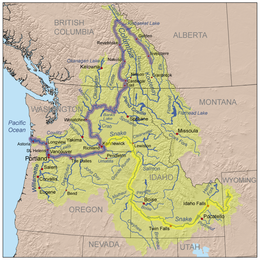 |
| Columbia and Snake Rivers |
Remarks: Modified: 02/15/2025
02/15/2025 --
No comments:
Post a Comment