Saturday, February 27, 2021

New Spain

TL;DR -- New Spain covered more area than New France. And, it had land that the U.S. wanted later than did any other country. Finally, a look at the situation. 

---

We finally are getting to New Spain after spending some time looking at New France.  Doing these other areas does a couple of things, at least. For one, New England dealt with others who were European and who were over here but outside of New England. It will be good to get a closer view of the events and activities where we can 'flesh' out the situation; this type of work makes the study of history to be more human oriented. 

The other thing is that the areas involved outside of New England were much broader in scope which we saw with the Louisiana Purchase. We backed into this study through looking at families that had gone west from both the northern and the southern parts (Virginia and surrounds) of New England. As we were getting familiar with details, it became obvious that we needed to stop and acquaint ourselves with the other colonialist's views. Jefferson did the Louisiana deal with New France, but the area had been under New Spain, too. 

Let's use Wikipedia. There are several maps on the New Spain page, but we like this one for several reasons. It shows the total scope of New Spain. The darker blue region is the original coverage. There is a medium blue region that New Spain got from New France. 

New Spain, colored in blue

Stopping for a minute, we can look at St. Louis, MO. It was founded by French trappers, as we would expect. However, the area had been visited by people from both New Spain (1500s) and New France (1670s). In 1764, New Spain got the area from New France who got it back later, prior to the sale to Jefferson. In the map, the light blue areas were obtained from New France. 

Except, there had been exploration along the left coast as shown by this map which is of the Pacific Northwest. 


In the southwest, New Spain ventured in from the coast. To wit, Santa Fe, NM was an early post. Coronado covered a lot of area which we will be looking at further. Reminder, we are talking 1540 which was the time of Thomas Gardner's great-grandfather. It was about the same time that de Soto ventured up the Mississippi to just south of where St. Louis is now. It was 100 years later when New France ventured into the same area arriving by a totally different direction from the Great Lakes. 

Coronado and his scouts

Lewis & Clark came through the St. Louis area in their 1804/5 trek. The fur business started to explode. And, then we had the early explorers. Missouri, as a State, had entrants on a regular basis prior to 1820s. As well, all of the characters that we have taken some interest in  (such as Jedediah Strong Smith) were in St. Louis at some time or the other. 

Even after the Jefferson deal, New Spain covered a lot of area. Those familiar with the modern maps can see Florida, parts of other southern States, Texas, New Mexico, Arizona and California across the bottom (others, such as Colorado, were above these) as parts of New Spain. At the same time, there were wanderers from out of New England, in the area. Some of these were early pioneers who planned to put down roots. 

New Spain, 1819

One thing that we can do is pick a few families for a focus. Francis Alcott Flagg had a long series about pioneers to the western front. You know, his research was related to Ohio, Michigan and Wisconsin. The area was considered the northwest (hence Northwestern University). Far west? 

We will (continue to) look at the total breadth of the emigration across the U.S. And, bringing in geography allows us to see the reality of the situations

Caveat: Using Wikipedia's  maps. If anything seems out of order, let us know. Meaning, Wikipedia is a volunteer effort and needs editors to keep information accurate and up to date. 

Remarks: Modified: 02/27/2021

02/27/2021 --  

Rootstech

TL;DR -- We will pay attention to technology in the small and in the large, especially that related to advanced software. 

---

We love Family Search and have used it since we started this work which was over a decade ago. At that time, some of the interfaces for genealogical packages were still fairly kludgy, so we did our own thing with respect to collecting and storing data. Now that we have more curating work to do, some decisions need to be made. A basic issue? 

There is one choice that people make. They can either go whole hog into someone's care by using a heavily GUI'd system. Or, they can take a more independent approach, as we did. There is a third way which balances the two. Many packages, in their latest manifestation, seem to offer better support. But, we like what WikiTree represents a solution to form and interface. The data is easily accessible, however one also has access to the mark-up level. Granted, this is not code, but it gives one the feel. On the other hand, access to support app extensions will be important, too. 

This year, for the first time, we paid attention to Rootstech which offers the framework with which to look at some of these issues in terms of genealogy work. We will browse this information later; too, we will pay more attention, especially to discussions about the future. 

Another note about the future? How AI will play in all of this? What is called the 'deep fake' approach now can generate photos of people who never existed. Too, it can create videos of characters who are not real doing things that seem natural. Some of the current results are easily analyzed with respect to its truthfulness. A photo might be obviously fake; the character in a video might stand out as a creation. However, this stuff will get more complicated as we go along. 

We have mentioned this before, but one of our research themes deals with these types of issues. Part of the work will be technical; some of it will be more general relating to the American experiment and its possible contribution to age-old dilemmas that are becoming more troublesome. We have mentioned, several times, that we are building a portal. Many times, we add 'to truth' with this type of work in mind. 

For now, we will start pointers to material that is of importance plus some on-going commentary.  

  • TensorFlow - From 2019. We saw this contribution by Google to what is called deep learning earlier. And, we have read the discussions about this as being the new AI. The approach has gotten attention due to its demonstrated effectiveness to the extent of watching. These things used by this approach are mostly black boxes for which lots of effort is being placed with regard to understanding what is going on. However, right now, the particular interest for us is the approach's use of graphics. This is not GUI in focus. No, we are talking the very core of our modes for modeling reality and for basing decisions upon such models.  
  • GitHub - This is a link to the material related to the TensorFlow article. That is, one of the modern benefits is having project and code management available for team work via the cloud. Nowadays, you see lots of papers offering their data via this method encapsulated with the algorithms used for the data. We are using this facility for our portal work, somewhat. 
  • Medium - This is the media that provides access to the TensorFlow article. We place it here as an example of sites that provide support in various ways which are going to be important in the future. 
We have to touched upon some of this, in our work, so far: Content can be configuration. And, we will be doing more. We have the technology blog for specifics which will become more active. 

Remarks: Modified: 02/27/2021

02/27/2021 --  

Friday, February 26, 2021

Research notes: Rivers

TL;DR -- The rivers of Yellowstone are featured. Too, there is a map of the water basins of the U.S. showing the large size of the Mississippi River and all of its inflowers. 

---

After focusing on the east coast as we got ourselves familiar with the Cape Ann venture, we started to follow western movements which had an early start that accelerated after the U.S. was formed. That change of scope led to us looking across the whole country to the west coast where people could have arrived by one of two ways, by water or by land. 

There are many maritime associations in New England to consider. Example posts are Gardner-Pingree house, The Gardiner that wasWhaling Gardners, and others. With Dr. Frank's TMM, we got acquainted with the long reach west of New England after the Revolution. However, going back in time, one sees the need to look at New France and New Spain. In particular, there was activity related to the fur trade that is within our scope; with that, we get into land movement and rivers. The major waterways were those of the Mississippi which cover the continent from Pennsylvania to Idaho. The former has ports; the latter is next to states with ports. In the below map, the Mississippi basin is colored pink. 

See Grasshopper Geography 

The following pertains to the upper left part of the pink area which is Wyoming and Montana. For reference, Gardner River starts in that region, flows into the Yellowstone River which joins the Missouri River in its long journey to the Mississippi. This area was a major playground for the trappers. 

Fur trading started early in the east (New England and New France) as traders bought furs from the American Indians. But, there was more demand than the American Indians could, or wanted, to provide. Hence, in the early part of the 1800s, we see the fur companies having their own trappers which changed the dynamic quite a bit. As well, we have events which gave stories (such as The Revenant or Grizzly Adams). 

There are many rivers in the Yellowstone basin with a lot more to look at; in the meantime, let's just consider some detail. There are two major rivers from the same location but going to the Missouri in two different directions. 

In this area of interesting rivers, we have a couple more. 

  • Lewis River, flows into the Snake River that goes to the Columbia River and the Pacific. This area is colored orange in the upper left of the map. 
  • Green River, flows into the Colorado River, then to the Gulf of California. This river basin is colored yellow in the lower center of the map. 

With respect to nearness, one motivation for relooking at the western rivers was learning of the portage of two-plus miles between the Fox River and the Mississippi that Joliet and Marquette took in their trek for New France. Essentially, they went from the Great Lakes almost to the end of the Mississippi River.

With regard to the Yellowstone area, the sources for these rivers are close in crow-flying terms (assuming they could get that high). Too, the comparison looks at the sources of the feeders/tributaries. So, taking the Lewis which goes to the Snake, at one point the waterways are with two miles of each other when looking at the boundaries of the Shoshone Lake (Lewis River) and the Yellowstone Lake. That is due to the width of the lakes. A comparison of the inlet positions shows the delta to be less than ten miles. 

However, travel between these two would be arduous, at best, and nearly death-defying in others. That is, before helicopters allowed types of leapfrogging not known to the trappers. The America Indians were in that area a lot, making use of what the valleys offered.  

---

Actually, we are remiss in not looking at the eastern part of the Mississippi system. Let's start with West Virginia which was part of Virginia until the Civil War. This list of rivers shows that most of the State's waterways drain into the Ohio which took lots of traffic west. Joliet and Marquette blew right by the Ohio's inlet to the Mississippi, but they were coming from New France. The other destination for the waters of West Virginia? The Chesapeake Bay, with  most of it going through DC's Potomac River which President George Washington was very familiar with. 

Remarks: Modified: 05/15/2021

02/27/2021 -- Changed to using American Indians. Added the TL;DR line. 

05/15/2021 -- Added link to later post that mentions The Revenant. 

Tuesday, February 23, 2021

Dorchester Company, further

TL;DR -- Need to look further at the Dorchester Company and what it meant to Thomas Gardner. Part of that will be getting familiar with Rev. John and his investors. 

---

It is time to spend more energy and time looking at specifics related to the commercial venture that was sponsored by The Dorchester Company. This will take several directions. While Rev. John White will be one focus, we will also take a closer look at the investors. For now, here are a few posts that we have done, to date, on the subject. 

  • The Dorchester Company (2013) - and Rev. John White (2013) One task will be to update this chart with a little more information on the Company and the investors, plus a more full look at the American experiment.

  • Two Thomas Gardners (2019) - Definitely, we need to look at Thomas Gardner who was married to Margaret Fryer and who stayed here. The other Thomas Gardner is mentioned by Frances Rose-Troup (2020) as having been married to Elizabeth, sister of the Reverend. 
  • John Tylly (2011) - As we mentioned long ago, we need to know more about John. Did he relate to any of the investors (The Original 119 Members)? 
  • Sir Christopher Gardiner (mentioned in several posts) - He is the cousin of one of the investors. We want to look at him further with respect to the different tales that one might run across. 
  • ... 

This is to fill in the whole picture as we look at New Spain and New France as well as New England. Of course, that brings in the whole scope of the continental U.S. early on, though we will still have a special interest in the western expansion after the Revolution. Again, USDAR will be a basis looking back 250 years, that is, both their database and their existence for the past century and a quarter plus. There is a lot to research with respect to the earlier 150 years, especially since Cape Ann has more of a significance than has been assumed, to date.  

Remarks: Modified: 01/14/2022

02/27/2021 --  Looked at the rivers of Yellowstone and New Spain. Added the TL;DR line.

08/09/2021 --  Gloucester's clock has 509 days to 2023.  

01/14/2022 --  Weymouth, MA's time has arrived. 


Tuesday, February 16, 2021

Gathering of the trappers

TL;DR -- Paintings by Remington and Jackson give a good flavor of the times. 

---

There were several ways to start this post, however using Remington is very much apropos. Picked this photo up from the page about Jedediah Strong Smith on the Legends of America site. We got to Jedediah through articles by Judge Thompson in Dr. Frank's The Massachusetts Magazine where the Judge wrote of his journey out west (over land, to the left coast, and back) in the early days. However, he was in a later time than that of the mountain men who were associated with the fur trade.  


We had not paid attention, but a movie (The Revenant, only saw the ads and read a few brief reviews) was showing in the 2015 timeframe. A little later, while we were trying to identify places that have Gardner in the name, we came across Gardner River that flows out of the Yellowstone Park area in Wyoming merges into the Yellowstone River in Montana. The namesake of the river, a little eddy along the river, and a town turned out to be Johnson Gardner. He was of the cohort of Jedediah. The movie is about an event in the life of Hugh Glass. He had a comrade named John S. Gardner who was killed in the same incident as Hugh was injured in. 

These guys were working for Gen. Ashley of the Rocky Mountain Fur Company. Ashley, himself, was out of Virginia and went west before the Lewis & Clark journey. Lewis & Clark were of the official world. We hear of mountain men and expect them to be roughed individuals. But, an added aura is the realm in which they were roaming. The American west. The painting above depicts these individuals coming to a rendezvous which, it turns out, was something that the General got started. 

This next two paintings are from W. H. Jackson: a rendezvous and view of a wagon train. These are meant to show some of the cultural context as well as the scope/scale of what we need to do. Paintings can be seen in the Eye for History publication of the National Park Service. 


As we look at these, we can not help but think of the "flyover country" discussions that were never resolved. 

So, let's end this post and look at what is coming up in the next few posts. We will look further at this fur company, in the context of the long reach of New England. Notice that where W. H. Jackson was born is way upper New York and close to Vermont. To us, that implies the possible links to Massachusetts, perhaps even Essex. Ann's great-grands went out to that area for a while. But, we have another puzzle where the lineage is along that border, and the family names are right out of Essex County (and Nantucket). No end to the work to be done. 

Too, though, we will look again at rivers and their sources. The Yellowstone area is interesting in this sense as it spawns a number of waterways. There are many ways that rivers come into the picture. But, too, as we work details related to events and people and their families, we will be aware of earlier takes on the matter, both the historical and the informal looks. 

Remarks: Modified: 03/08/2021

02/27/2021 --  Looked at the rivers of Yellowstone and New Spain. Added the TL;DR line. 


Monday, February 15, 2021

Rivers and more

TL;DR -- Further look at the Mississippi and the portage area in Wisconsin that links the Fox River with the Wisconsin River. 

---

As mentioned before, rivers facilitate travel, however they are also barriers to movement. People moving west out of the east coast traversed large chunks of land as well as crossed over major rivers: All that Louisiana brought. That post looked at the Mississippi watershed which covers almost the whole of the continent, as the river came to the U.S. from the area of New France. Getting familiar with specifics reminded us that we need to look at the other colonies. There were New France, New Spain, New Netherland, and New Sweden. The last two were short-lived, albeit the effects of that effort remain visible until today. It was England, France, and Spain who continued in their conflicts for another century plus. 

Before getting to the theme of the post, let's use a better image from Wikipedia that shows the major tributaries of the most major of the water systems in the U.S. This post deals with an area in the north central of this map (that is, to the upper right of the heavy blue line). Later, we will back up and update an earlier post about the Gardner River which is in the upper left (Yellowstone area). To be complete, we have to look at the other major systems in the west that do not drain into the Mississippi (Columbia, Rio Grande, Colorado, and few smaller systems in the west, plus Texas and its rivers - Pecos and all). 

Mississippi River

So, the theme continues to be about rivers. The Wisconsin and the Fox rivers are so close in Wisconsin (see upper center part of the above map, to the right - the Wisconsin is shown) that a portage was established way back in the 1600s (of course, known way before the Europeans arrived at the scene) that allowed travelers (their original location was the St. Lawrence area) to use the Great Lakes to get to the Fox River (via Lake Michigan) and over to the Wisconsin River so as to get to the Mississippi and venture south toward the Gulf of Mexico. That party traveled down past the Missouri River to the Arkansas River which are both carriers of water from the Rockies. 

What was interesting to learn was the height differences from Lake Michigan to the Mississippi Valley plus the short distance of the portage which was less than three miles. The graphic depicts the elevation of the locks that were established to allow transportation to use the route. Prior to that, there would have been manpower in movement of the vehicle as well as other portages in order to bypass rough areas. Albeit, none of that would have been too strenuous in normal conditions, compared to what was coming for travelers as they got past the area of the plains. 

Fox-Wisconsin Waterway

These early travelers (Joliet and Marquette) were French with American Indian guides and turned around at the Arkansas as they saw evidence of Spanish culture. On their return journey, they blew by the Ohio (different culture - we'll get to it as a main waterway from New England) and took the Illinois River back east. They had a bit of a longer portage to get to Chicago and Lake Michigan, however the going was easier. Just for comparison, here is the waterway that was developed later to allow and maintain water traffic from Chicago to the Mississippi River. 

Illinois Waterway

Notice the elevation changes. Chicago is 597' more or less above sea level. Grafton, IL is 435'. At its confluence with the Ohio River, a little further south, the Mississippi River is at 315'. This is a low spot as going west would have had one climbing to the Rockies and beyond, over a long bit of terrain. Lewis & Clark paddled their way up. Later, ingenuous people had flat-bottom boats with power. However, even those could not handle the rough water.  

In the context of these waterways, the later trekkers would have seen these as a barrier which would differ by the time of the year and the weather. Spring runoff in this area can be quite large. It was not too long ago that we saw a huge flood cross the landscape from a large snow melt in the Rockies to the Mississippi along the Missouri River that took months as it went from state to state. When it finally arrived, in an area, everything within the flood plain was under water. There would be no concept of the flash flood unless one was looking at upstream penetration in tributaries as the water rose. Usually, flooding is a downstream affair. But, there can be back up given the right conditions. 

So, in those early times, none of this would have been known. One service that would have been established later was a ferry. The Massachusetts group that went to Lawrence, KS went over the Wakarusa River after they left the Gardner, KS area. Later, there was a ferry put in at that location between Kansas City and the Lawrence area. Imagine a wagon train, though, with each wagon awaiting the back and forth. Gives "all in a day's work" a whole new meaning; rather, it's a forgotten one. 

Remarks: Modified: 11/29/2022

02/16/2021 --  Got to love Wikipedia. This post lists rivers of the U.S. by length. The Missouri tops the Mississippi by a 100+ miles. It's due to those twists and turns in the mountains of the west. Also, for each river, it shows where it drains. Note that six major rivers flow into the Mississippi. Then, each of these has many rivers flowing into it. So, the Mississippi system is huge. 


See also, list of longest rivers by state. For each state, there is a link to the list of all rivers with a map of the river. Again, Wikipedia, and its volunteers, are a marvel of the age. 

The USGS has a nice map that allows attention to details

02/18/2021 -- Our post on trappers shows a W. H. Jackson painting of wagons crossing the South Platte. This was risky. Notice that extra oxen were used. However, in shallow spots, a ferry would be difficult to manage, too. 

11/29/2022 -- Refresh the elevation view of the Illinois Waterway. 

Other new attempts

TL;DR -- There were other countries in the area: Sweden, Netherlands. 

---

New Netherland (c 1684)
We started with New England for obvious reasons and recently decided to look at other colonies since our focus, in part, is the total of the North American continent. New France was brought into the picture due to its geography and its role in many conflicts. Also, it did the early studies of the Mississippi region. However, when the Louisiana Purchase expanded the western regions of the new U.S., it was Spain with whom we did the deal. We do need to look at New Spain which covered a lot of area, so we will look at that in the next post. 

Before we go into some details of New Spain, there were two other close colonial attempts. These were New Netherland and New Sweden

New Sweden

The former is better known having left behind whole areas that are part of our modern culture, such as New York. The map shown at the right is noted to be fairly accurate given when it was drawn up. The earliest Dutch settlement was in 1613. After the arrival of the English, it wasn't long before New Netherland was being encroached upon from the north by the settlers. 

Later, in 1638, there was a Swedish colony established in Fort Christina on the Delaware River. This was the first of several countries who tried to make a foothold (Finns and Germans). 

New Sweden was principally in the Delaware Valley. Mapped out in 1637, there was a build up of settlers until were several town and hundreds of residents. The area was taken back by the Dutch in 1655. The English got New Netherland in 1674. 

As we will see in the  next post, New England picked up a large part of eastern New France with New Spain getting the larger portion of the west that we saw again in the Louisiana deal. 

Remarks: Modified: 08/14/2021

02/27/2021 -- Looked at New Spain. Added the TL;DR line. 

08/14/2021 -- Started a New England look as Weymouth is next year (2022). After that, the locale of our focus, Gloucester/Cape Ann. Coming soon will be a continuing series on slavery and associated topics, such as the Quakers, abolitionists, Civil War, and more emphasis on the relationships with the American Indians. Plus, point to world events through those 400 years; the U.S. was not in isolation. 

Friday, February 12, 2021

New France

TL;DR -- French-Indian War? Which one? New France? We find out more about this colonial effort by France that covered a larger area than New England. 

---

Our research focus started in Essex County as Thomas Gardner was a central figure. From there, we branched to Massachusetts and surrounding areas as people moved west and south (to us, families include collateral relationships whether by blood or marriage). For instance, families from Ipswich were out in Ipswich Canada early on (puzzling, at first). Too, there were pioneers who went out to southwest Connecticut and then New Jersey. Then we got to follow families to the southern New England and then out west. Finally, we started to take a look at the groups that came in later, prior to the Revolution, and expanded our scope to "All things Gardner" somewhat. Then, we looked at families post the Revolution both in New England and across the U.S. The western expansion got a lot of our attention due to the long reach of New England throughout the States. Looking at these families led to considering events prior to the Civil War and after. 

All the while, we kept ourselves to looking at English culture in the various forms here while staying within an adage for researchers here to not look over there (let's the Brits handle things). Well, that didn't last long, as we saw with the Magna Carta celebration in 2015 that groups in the U.S. were a main motivator for getting celebrations going and sustained. The ABA sponsored placement of a memorial at Runnymede. 

We never looked closely at conflicts in terms of parties and motivations. Except, we did look closely at the years going back between Cape Ann and King John's time, we saw lots of conflict. Much of this was cousin quibbling. 

As well, Dr. Frank noted that the leaders of the U.S. Revolution had been trained by the Crown by their involvement with the French-Indian war. Then, later, we were reminded of the Queen Anne war, basically through reading about the Pamphlet War. There is always research being done, however continuing improvements in technology will facilitate lots of work that was not possible before. Examples abound which will be included in our bibliography. 

Reading of the Queen Anne war got us looking at the particulars of what went on. English-French ties are ancient, way before William I's incursion. Too, though, we started to look at the history of different areas of the U.S. where families of English heritage were moving. And, that got us reminded of other cultures. Of course, we had already discovered that there were Gardner descendants who were of American Indian heritage. The cultures that were here prior to Europe will be the basis for presentations as we go back that fill in the pieces related to events and people. This is an example (Wikipedia is probably the best curator of disparate information and views on the planet; do you support it?).

These are separated out by centuries. We have already mentioned some. Such as, Joseph Gardner being killed in the King Philips's war. He, and Ann Downey, had no progeny so they will get special attention

But, conflict here, in the early days, also was going on in Europe. We have mentioned Spanish influences a time or two. But, there was one huge absence. Fortunately, we don't have to venture far to find a connection. New Hampshire was considered part of New France at one time. We have not paid attention to that much, seeing it mainly as where Rev Stephen Bachiler went to get away from Winthrop and friends. 

So, let's correct that. First, let's use a 1681 map from Joliet's and Marquette's journey out west in 1673. That was one year prior to Thomas Gardner's death. We just looked at that, briefly, noting that they went from upper Lake Michigan to Green Bay to the Fox River and down to the Mississippi. We will have a post soon on that and an update about Gardner River further west. This map shows the Arkansas River where they turned around as they started to see evidence of Spaniards being around and about. 

Map of Joliet's and Marquette's tour, 1673

This next map, we love. It's from 1688, and shows how huge New France was compared to New England, both north and south. Of course, upper New England was more populated in certain areas. We will look at that. However, that this was mapped out so early is astounding. However, the left coast is not in the picture at this point in time (claimed by the Spanish). 

Early view of New France

Now, these maps are from the latter part of the 17th Century. Things really changed the next century which as 100 years before the Louisiana Purchase which we looked at last year in terms of how people moved. 

We mentioned that we have many generations to look at. The 5th generation bore the brunt of the Revolution. The 4th was there, leading. The 6th was there as a transition. After that, New England mostly was maritime which we have looked at. Now, we can look at the landlubbers which we started to do from the perspective of D.A.R. with its 250th celebration of the Revolution coming up. D.A.R. itself dates from the latter part of the 19th Century. 

We are going to look very closely at the 150 years from the Revolution back to the Cape Ann times (upcoming 400th). And, given now the broad sweep across the continent, there is a lot that can be done. 

Not only can we consider families and their genealogy, we can look at generations and their times. The main boon of the internet (the reason for its existence) is knowledge sharing. So, we will see more research and reports from such, many taking avenues that are creative and unexpected. There are media issues for which we have a technology focus, to boot. 

But, stories of the characters of those times, generation by generation, will be something to look forward to. 

Remarks: Modified: 02/27/2021

02/27/2021 -- Further on the western rivers (and the Missouri River). Changed to using American Indian. Put in the TL;DR line. Looked at New Spain


Tuesday, February 9, 2021

Mississippi and Fox Rivers

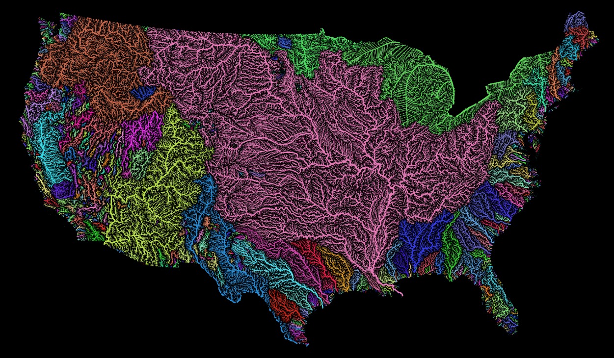
TL;DR -- With a portage of a mere two plus miles, a route was shown from the Great Lakes (ultimately the Atlantic to the east) to New Orleans. Example of the importance of waterways to both migration (barrier) and commerce (traffic way). 

--

Going back before the Revolution is necessary if we are to have the proper view. So, we are approaching 250 years from the U.S. start and are past 400 from the Plymouth arrival. That gives us an additional 150 years to look at which will be four to six generations. 

We have covered many topics about lots of areas of the country, especially looking at the theme of western expansion that started after the expedition of Lewis & Clark in 1804. Their venture from the east coast was along the normal route that we usually considered where people traveled from the east down the Ohio River to the Mississippi. Then, they could go south to several points or backtrack up the Mississippi to the Missouri River and then head west. At the area now that is Kansas City, they could  go by foot or stay on the river up to Nebraska. If going by foot (of any of the animals involved), the goings were over one of the 3 Trails. If getting off the river in Nebraska, they headed west and met those on the Oregon Trail from Kansas. However, if one wanted to go further north, one could use the Missouri River to Montana. 

For a timeframe, we have looked at the period after 1804. But, we knew that there was activity before then. Long before, it turns out. Our research had us looking at families that came west either from the north as described above or from the south where they followed Boone's route. That is, if they were heading for the middle part of the country. If they were going to the south, there were other routes. In particular, we were following a family that came west from North Carolina (part of the family from Virginia and parts north) to Tennessee. Then, there was movement across Tennessee to Missouri and then Texas and back to Arkansas. That is where we found that the History of Arkansas is as old as that of Massachusetts in terms of exploration. Just like Kansas was visited from the southwest (out of Taos) in the sixteenth century where Coronado was not far from the Gardner Junction area, De Soto came up the Mississippi to a point near southern Missouri. This was in the mid-sixteenth century (1541). So, that area already had its 400 and is not far from a 500.    

A Spaniard made it up to where Missouri and Arkansas now meet a hundred years before the Mayflower. And, he saw the Arkansas River that has water from the Rockies, assuming that some water might have made the entire journey as there are sufficient rains for replacement plus lots of dry areas where the river disappears underground. A little later, travelers from New France came to the same area from the northeast. 


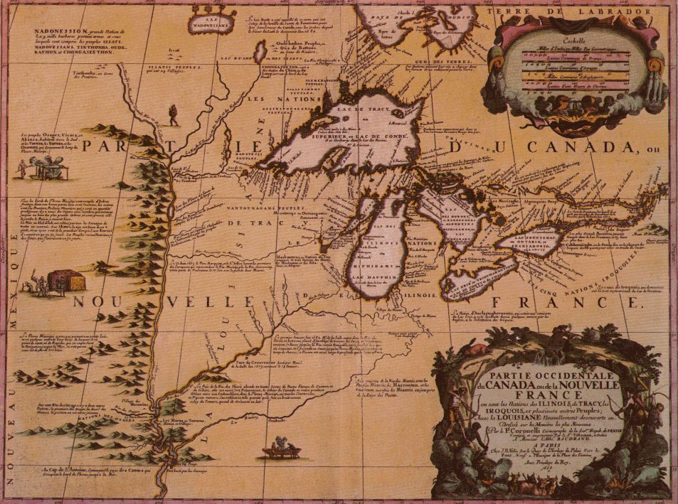
This map has south to north oriented as left to right with the Gulf of Mexico on the left coast. It was Spanish territory. Whereas the travelers were French. The two didn't mix at the time. On this map, the Arkansas is the first river from the left heading up at an angle from the main line. The next one that is  above the line (Mississippi River) is the Missouri River. Notice, the mappers blew right by the Ohio which goes all the way back to the western part of Pennsylvania. Proceeding on to the right, they show the Illinois branching off from the bottom of the line. Finally, the Wisconsin is shown toward the right.

The travelers came west via the Wisconsin River, went south, and then went back via the Illinois River where there was a portage needed to get to the Chicago area. Okay, that was nice to know that this looksee was one year (1673) before Thomas' death. Given the issues between England and France which bubbled out a little later, one wonders how much interchange there may have been between these two groups (New England and New France). Would any type of incidental exposure even have been documented?  

We have to ask, have we been looking too much at New England? What's the modern concept, echo chamber? There's a reason to ask, as we find all of the time that some things are seen differently and that this difference can be seen in reports. One related to Oregon is still pending further study. Now, we can deal with events not seen earlier due to the lack of communication in the prior times. With the internet and digitization of data, we can actually do some matching up now that was not possible before. A big concern is provenance of the new data (see posts related to Margaret's parents, as an example). 

The U.S. consisted of several pieces tied together. Joliet and Marquette (1673, see Reminiscent history of the Ozark Region, pp 16,17are the names of the men who came out of Canada from the northern shore of Lake Huron where they had arrived via Lake Erie from the St. Lawrence area. We were just looking at the early phases of the French-Indian Wars from the side of New England, so we'll go back and consider the other side(s). 

Anyway, going a little south along the western shore of Lake Michigan, J & M got to the Green Bay, WI area and picked up the Fox River. This is where it gets interesting, in that an earlier post looked at Gardner River in Wyoming which in Yellowstone. There, we find a little split where one flow goes to the Yellowstone River, then the Missouri River and then the Mississippi River. A little bit away (crow-fly measure), the Snake River starts and empties a watershed for water that heads west. Wyoming also has flows that go south to the Great Salt Lake or head east to the Platte River which eventually gets to the Missouri way past where the Yellowstone comes. 

Crow-fly? We will look at that in a later post. On the other hand, near where the Fox River ends in WI in one location, it is a mere two, to three miles, from the Wisconsin River which is a tributary of the Mississippi River. The map shows the two rivers and has the area marked where they almost converge. The site is now Portage, WI. 

This means that one could leave upper New York as did the party that left Massachusetts with Lawrence, KS as their destination in the 1854. After getting to New York and Lake Erie, they boated to the Chicago area through the Great Lakes (Cordley only mentions Lake Erie, but they would have gone through Lake Huron, as well, and then down Lake Michigan). Then, they got to the Illinois River which got them to St. Louis, MO; from there, they took the Missouri River to Kansas City and got themselves down to Overland Park. The party proceeded on foot to Lawrence by way of Gardner's Junction and founded the town and the University of Kansas. This was part of the Free State effort prior to the Civil War. Col. T. W. Higginson was out there a little earlier and but had to go overland through Iowa the rebels had the river closed down. 

Now, we are putting this view of the Mississippi that showed it and its tributaries to be barriers as well as enablers to movement.  

As we were researching, we ran across several articles and papers. This paper is from a college in Michigan and represents some of the type of research and reporting that the TGS, Inc. wants to support. 
What's not to like, the paper mentions MerryMount

A further topic will be the North American fur trade. Also, we will relook at the area where there is the split in the west (almost Idaho where there is a small separation between the starts of flow back to the Mississippi versus to one going west to the Columbia River. While we do that, we will look at the explorations of Yellowstone starting with the unofficial ones back in the time of Jedediah Strong Smith, through the times of gold explorations, then looking at the official surveys which were later in the 1800s, and then consider the time of the designation of the area being a National Park. 

Remarks: Modified: 02/27/2021

02/10/2021 -- Added links. Improved some of the verbiage. Brought in map drawn in Marquette's time. 

02/13/2021 -- We will look at New France in more detail. About time. 

02/16/2021 -- We mentioned the fur trade. Consider our post on the Gathering of the trappers which is a title taken from a W. H. Jackson painting. In particular, we look at General W. H. Ashley and his crew of trappers out of St. Louis, MO. W. H.? William Henry. Must have been popular (some message there/). 

02/27/2021 -- Further on the western rivers (and the Missouri River). Put in the TL;DR line. 


Sunday, February 7, 2021

Super Bowl

TL;DR -- Mahomes of KC has early American cousins. 

---

Today's game. This is an example of a whole new industry that has exploded way beyond expectations. If we didn't have the virus as a factor, Super Bowl LV would have been even more spectacular than the one last year. Will there ever be partying like we were seeing before? We have the playoff games and then two weeks to build the hype. Then, the game starts. The half-time entertainment works or does not; some might say that it has been the latter, for the most part. Then, the game gets over with it's usual split into two parties. Someone has to win. 

The last post was a continuation of the American Cousin series which will be even more open-ended due to all sorts of factors. Along with looking at descendants of Thomas and Margaret, we want to look more closely at collateral families. Those are usually blood, however we will consider the in-laws, too. That is due to our interest in American History. 

This post is motivated by NEHGS. In their blog, they discussed the ancestry of the Kansas City Chiefs' quarterback, Patrick Mahomes (Super Bowl surprise). This chart has a line that starts from Thomas Gleason (d 1686, Cambridge, MA) and Susannah Page and a line from Michael Bacon (d 1648, Dedham, MA) and Alice. 

Mahomes-chart.jpg

The surprise might be that Patrick is related to three Presidents: Colidge through Michael Bacon; Hayes and Bush through Thomas Gleason. In looking at these, we see lots of cousins. So, we will pursue that. Meanwhile, we will collect examples of these types of relationships within various industries as we started with the Wikipedia page (fortunately, there is a history: en.wikipedia.org/w/index.php?title=Thomas_Gardner_(planter)). 

Remarks: Modified: 02/09/2021

02/09/2021 -- Mahomes seemed befuddled. Lingering effects from a concussion? KC lost.    

Friday, February 5, 2021

American cousins

TL;DR -- We have Brit cousins. However, we have many American cousins, too. Some of these are closer than others. Keeps the research going. 

--

Until of late, we have ignored the British cousins but will have this theme more to the fore in our research. One reason for this is that when we got started, there was an adage: Americans worry about stuff over here; let the Brits take care of things on their side. Meaning, we had enough worries trying to iron out genealogical/historical issues here without venturing further. On the other hand, no one really followed that adage (we did as we had enough to do). So, we're opening the door. 

We have looked, somewhat, at American cousins, mostly from the view of descendants of Thomas and Margaret. In particular, we intended the scope to bring in collateral families (and have somewhat). 

As we read and find potential New Englanders, we mostly look to see if their heritage is described somewhere. Today, we're adding William H. Macy, about whom we read in the WSJ. He will be on the list of descendants, via son Richard (several times). This link is to his father's profile on WikiTree (William Hall Macy, Sr.). We'll look into WHM further as we have time. We have not added him yet, but we are looking at the pedigree of William C. Coleman who has lots of evidence pointing to early New England.  

As well as those of the Thomas Gardner family, we have been asked to research members of other Gardner families some of whom were mentioned by Dr Frank in  his books. Some of these have already been mentioned in posts. After looking at a few, we will mention two other persons with a Gardner in their tree. 

  • Henry D. Gardiner -- he and his brother owned several ships one of whom wrecked off the Oregon coast. This is an open area of research (Historic puzzles, The Gardiner that was) since the interpretations of what happened seem to differ. 
  • Gardiners Island -- Lion was here early but spent more time at the lower part of Cape Cod. We want to learn more of the provenance of a painting that bears strong resemblance to family members. 
  • Gardner River -- southern family who was out west during those early times of the country. 
  • Privileged or not -- family of Silvester who is a descendant of George Gardiner of Rhode Island as was Henry D. Gardiner. 
  • Malcolm H. Gardner -- he was head of a Holstein association dealing with diary farming. 
There are several studies going on, but taking two actors can show an example. Sometimes, we look at Famous kin; but, we are leery since we have seen some discrepancies. 
  • Kyra Sedgwick -- her grandfather (Robert Minturn Sedgwick) was a descendant of Thomas and Margaret Gardner, via son George who was the father of Samuel and the grandfather of Hannah through his mother. George was of the Gardner Memorial book. Kyra is also a descendant of Lion Gardner
  • Kevin Bacon -- spouse of Kyra; he is descendant of a Thomas Gardiner who married Susan Elton in Philadelphia in 1748. This Thomas was not on our list that was an extension of the one started by Dr Frank in his 1907 book. The list was updated in 1933 in Gardner's Memorial.  
Kyra has been added to the list of descendants via George. We will continue to research others as we have time. 

Remarks: Modified: 02/27/2021

02/27/2021 -- Added the TD;LR line.