TL;DR -- The rivers of Yellowstone are featured. Too, there is a map of the water basins of the U.S. showing the large size of the Mississippi River and all of its inflowers.
---
After focusing on the east coast as we got ourselves familiar with the Cape Ann venture, we started to follow western movements which had an early start that accelerated after the U.S. was formed. That change of scope led to us looking across the whole country to the west coast where people could have arrived by one of two ways, by water or by land.
There are many maritime associations in New England to consider. Example posts are Gardner-Pingree house, The Gardiner that was, Whaling Gardners, and others. With Dr. Frank's TMM, we got acquainted with the long reach west of New England after the Revolution. However, going back in time, one sees the need to look at New France and New Spain. In particular, there was activity related to the fur trade that is within our scope; with that, we get into land movement and rivers. The major waterways were those of the Mississippi which cover the continent from Pennsylvania to Idaho. The former has ports; the latter is next to states with ports. In the below map, the Mississippi basin is colored pink.
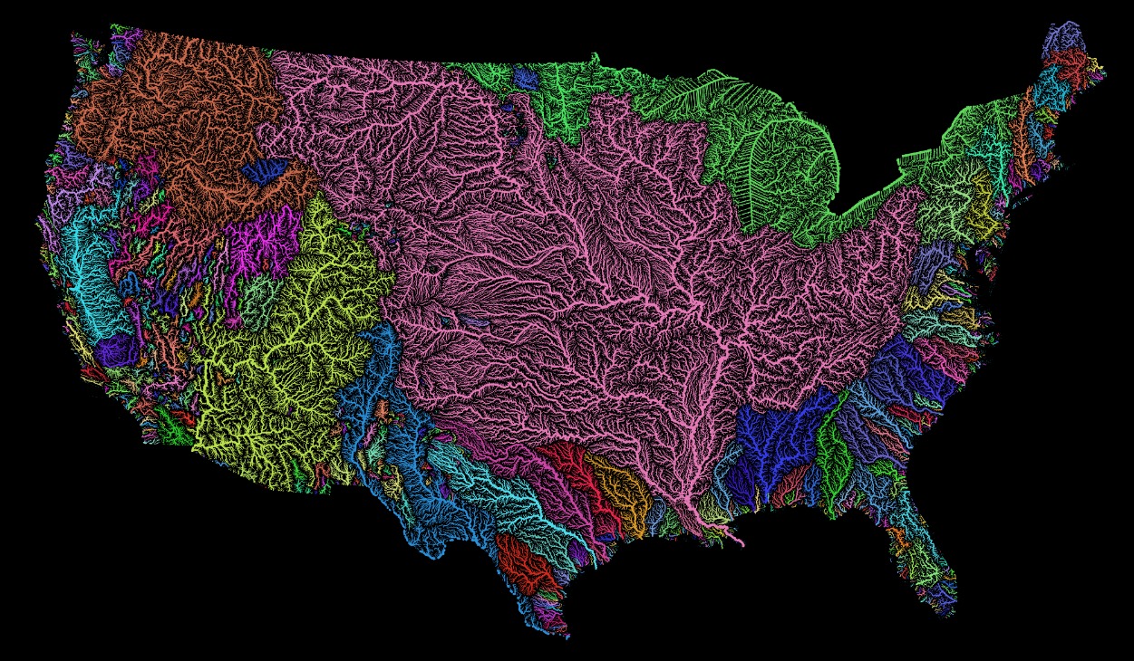 |
| See Grasshopper Geography |
- Yellowstone River, Younts Peak
- Gardner River, Joseph Peak, feeders: Lava Creek, Obsidian Creek, Glen Creek, Indian Creek (Wyoming)
- Big Horn River, Togwotee Pass, meets the Yellowstone after 400+ miles.
- Madison River, fed by rivers from Yellowstone: Gibbon (Grebe Lake), Firehole
In this area of interesting rivers, we have a couple more.
- Lewis River, flows into the Snake River that goes to the Columbia River and the Pacific. This area is colored orange in the upper left of the map.
- Green River, flows into the Colorado River, then to the Gulf of California. This river basin is colored yellow in the lower center of the map.
With respect to nearness, one motivation for relooking at the western rivers was learning of the portage of two-plus miles between the Fox River and the Mississippi that Joliet and Marquette took in their trek for New France. Essentially, they went from the Great Lakes almost to the end of the Mississippi River.
With regard to the Yellowstone area, the sources for these rivers are close in crow-flying terms (assuming they could get that high). Too, the comparison looks at the sources of the feeders/tributaries. So, taking the Lewis which goes to the Snake, at one point the waterways are with two miles of each other when looking at the boundaries of the Shoshone Lake (Lewis River) and the Yellowstone Lake. That is due to the width of the lakes. A comparison of the inlet positions shows the delta to be less than ten miles.
However, travel between these two would be arduous, at best, and nearly death-defying in others. That is, before helicopters allowed types of leapfrogging not known to the trappers. The America Indians were in that area a lot, making use of what the valleys offered.
---
Actually, we are remiss in not looking at the eastern part of the Mississippi system. Let's start with West Virginia which was part of Virginia until the Civil War. This list of rivers shows that most of the State's waterways drain into the Ohio which took lots of traffic west. Joliet and Marquette blew right by the Ohio's inlet to the Mississippi, but they were coming from New France. The other destination for the waters of West Virginia? The Chesapeake Bay, with most of it going through DC's Potomac River which President George Washington was very familiar with.
Remarks: Modified: 05/15/2021
02/27/2021 -- Changed to using American Indians. Added the TL;DR line.
05/15/2021 -- Added link to later post that mentions The Revenant.
No comments:
Post a Comment