Showing posts sorted by relevance for query california trail. Sort by date Show all posts

Tuesday, August 11, 2015

Gardner, KS

Earlier, we looked at places with the Gard[i]ner name. Then, we took Gardiner, OR and wrote about the person for whom the town was named, Henry Dearborn Gardiner (pg 31, v 35, no 1, TEG; pg 6, v II,n I, The Gardner Annals). That same family was the inspiration for Gardiner, ME.

So, talking of Oregon, there is a town on the trails (see next) in Kansas, named Gardner. It may have been named for Henry Joseph Gardner, Governor of Massachusetts (1855-1858) as there were many pioneers from Massachusetts in the area.

First, about the town. It was where three trails split into two: Santa Fe Trail, Oregon/California Trails. The Santa Fe Trail ended up in a city in one of the oldest areas of the U.S. The other two trails were coincident until much further west where the California Trail headed south; after going west out of Gardner for awhile, they headed up to Nebraska then west to what is now called Wyoming.

Now the Gardner was Henry Joseph Gardner who was a descendant of Richard Gardner of Woburn who is on the list provided by Dr. Frank (the Gardners and Gardners post is the most popular all time).

---

The mid-west and central parts of the country are full of displaced New Englanders. A little up the road from Gardner is Lawrence whose main drag is named Massachusetts.

Remarks:  Modified: 06/24/2022

04/02/2016 -- Map showing Gardner Junction and the split of the trails west of Gardner, KS.

08/13/2017 -- Posts on Lawrence (and surrounds): Trails West, Westward Ho, Blogging and such, Final Migration, Thomas Wentworth Higginson, Kansas and Lawrence. 

10/26/2018 -- Map of Gardner Junction. 


08/07/2020 -- In this post, we are looking at two disparate spots that share a name, however there are many points in-between. Like Eudora, KS. Where "The Wakarusa meets the Kaw" is on their history site and is an example of local lore getting some attention. See "Along the Western Trails."

06/24/2022 -- Updated links to Eudora's website as topic continues to be of interest: A Ride to Kansas. 

Thursday, July 25, 2024

Oregon, by land

 TL;DR -- Getting to Oregon, however done, was arduous. Today, we look at the land routes and note that the ordeals are subject of studies and have been for over a century. 

--

Oregon is in the west, nestled above California. They respect their history ought there so preservation of material is a common theme. Recently, the Oregon-California Trails Association had their meeting. 

There were several ways to get to the west coast and Oregon from New England. We covered the water route in several posts and articles: The Gardiner that was (2018). Gardiner's barque left Boston in July of 1849 and got to San Francisco in January of 1850. It had passengers and sold its freight at the harbor. There was a subsequent voyage to New Zealand. In October of 1850, the barque (Bostonian) wrecked along the Oregon Coast. 

Family members went out another route which was descent to Panama, getting across to the Pacific, and taking another ship north. The return trip was as arduous. We'll look at that further at some point. 

We have written a lot about the land route. As, for a while, the trail went through Gardner, KS (3 Trails, 2019) where it split with the Santa Fe Trail. Over time, as people got familiar with the Kansas City area, they ventured north on the Missouri River to where they could cut out KS and go through NE. This saved a few days. 

Young bucks in high fever were in a hurry to get to the gold field. 

On the journey through Nebraska, the traffic went by Scotts Bluff (Facebook). For now, we put in a photo of the new and the old way which is apropos. People still ride the trail; one of the east-west Interstate Highways runs through the area. So, a brief nod to technology. 

Eagle Rock and a solar car, 2022

Now, let's go further west and look at another split. In Wyoming, the US Government sponsored work to shorten the trip to California. Lander Road was the cutoff that was made. This bypass saved 60 miles for those going to California via the southern route through Idaho. 

Lots of trails crossed the countrry. We appreciate that folks keep up attention on these routes and work to preserve the historical aspects. We expect that the coming 250th of the country will see a surge of interest. At the same time, we need to keep technology on the beneficial side of things, especially with regard to its potential for aiding historical work. 

Remarks: Modified: 07/25/2024

07/25/2024 --    

Sunday, December 11, 2022

19th Century details

TL;DR -- Earlier we took a look at transcontinental travel in the early 19th century and its ardors. There was nothing easy about the ordeals, but people took up the gauntlet. Here we look at one site where travelers made their presence known and link to a map that has local details of interest. 

--

We have had several posts on trails. Recently, we looked at a well-known trail (to Santa Fe) as it was the terminus of another trail in New Spain which provided other trails such as that which provided a route used by the Butterfield Overland Mail Company in carrying mail, freight, and passengers from the east coast, through St. Louis and to San Francisco. This was pre-Civil War and was interrupted. Further north, the Pony Express went from St. Joseph, MO to California carrying mail. Butterfield established a new route up north using coaches. Mark Twain wrote of his journey on this route. 

There was another Butterfield in that area who was not related and who had a  Butterfield Overland Dispatch (using a post at the Legends of America site) through Kansas. Both of these Butterfield gents had investors back east. The amount of stations, equipment, horses and people required to have regular routes was tremendous. As we know, the rails of steel were going to play havoc with these routes. But, that was enough later for history to be made. 

As a reminder, at the same time, there was regular traffic from New England which moved south by sail to the area of Panama which involved going across land from ship to ship and then sailing back north. Of course, one could go around South America. We looked at this briefly when writing of the Bostonian (barque) that wrecked along the Oregon coast in 1850. The barque left Boston in July and arrived at San Francisco the following January. It was later seen in New Zealand and, evidently, carried goods to San Francisco before venturing north to its fate. Gardiner, OR resulted from that incident. The overland trails had as many dangers; but, even without those happenstances, the travel was arduous. 

Besides looking further at the specifics of these overland efforts where we find the two Butterfields, we want to bring in more detail as is required for doing history of the events better and for considering the people involved in a more respectful light. Also, the area in the center of the U.S. was very busy. For comparison, we looked at a railroad town and its specifics from the early 1900s (see KATY - western railroad). 

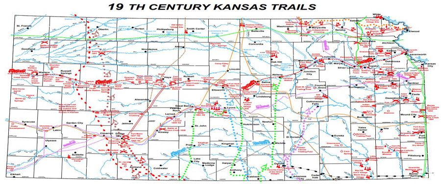
Let's start with a map that comes from KDOT (see 19th Century Kansas Trails). Notice that the Santa Fe and Oregon Trails come into the area in the northeast corner. The Oregon Trail splits off and heads northwest. Another trail in that area is the Butterfield Overland Dispatch which terminated in Denver, CO. The other Butterfield route would have been north of this area. 

Click for detailed 
map from KDOT

The map includes other trails of interest including those used by indigents and that related to the cattle trade where heads were brought as herds to a rail terminus for loading. As one looks at images, the wild west was in this area (see Dodge City). "Hell on the plains" might apply to our few decades of the web. 

Looking at some of the details, there was a military road (double green) that went from Ft. Leavenworth to Ft. Scott and further south. This was there early. We mentioned a Mission in the southeast corner (see Memorial Day 2022). Nathaniel Boone (son of Daniel) was in the area. Col. T.W. Higginson was in Lawrence and Topeka. Lawrence was founded as part of the abolitionists' interest in keeping Kansas free. Take a close look and note a trail (blue dashes) from Leavenworth which was originally for supplying Army posts as they expanded westward but ended up with a California connection. 

In a recent post, we looked at how Ipswich MA got Ohio going. That was not long after the Revolution and was similar many ways with what happened later out west. In fact, we included a graphic (map) showing both areas. So, we could look at this type of detail across the whole of the region. 

One of our interests is the long reach of New England. Both Butterfields were from New England (their relationship, if any, needs to be researched). For the most part, we will be taking time to link with both genealogical and historical information (see Lorenzo and Peggy). As well, we have a technology interest and want to include specifics of the reality of the earlier times. After all, everyone here had forebears who were alive then. The particulars of the American west are such that we can see the transitions clearly over the frontier century's span. We mentioned it before, but this map brings up the fact: going from the northeast (Kansas City) to Ft. Larned (south central, look for Great Bend) took three weeks of daily work on the Santa Fe Trail. 

One more detail, Jedediah Strong Smith was last seen in the area of Point of Rocks (lower left - southwest). He was killed by an indigent part. 

Remarks: Modified: 12/12/2022

12/11/2022 -- 


Saturday, July 27, 2024

Three weeks

TL;DR -- We take modern travel for granted. To wit, the Delta recoil from the Microsoft fail just a week ago. Now, we can look at the details, and ought to. As well, let's ponder three weeks of travel back in the good old days.  

--

Having just written on Los Angeles and then finding more information on the California Trail to which travelers on the Oregon Trail switched if they were headed to the Great State of California. Per usual, everywhere we look in the US, we seek out connections to New England. 

A recent focus on Bunker Hill West brought to fore lots of information about people from the east coast and their activities on the left coast. For the record, this area in downtown LA is where we now find the skyscrapers. But, under many of those are destroyed records of, at least, two cultural developments. Fortunately, there is an association in LA that has photos and records about the different eras and areas. 

That will be a regular theme along with technology which comes into play due to the potential for mischief. Already, we have seen photos that seem to have been generated by methods other than a human with photoshop or the like. We're not paying close attention, yet, as there are plenty of photos for study from the repositories that are available. 

On the other hand, tales of people abound and mostly are not known. Technology, you see, can be a boon as it will help document the past better than we have ever seen. 

Case in point, in the graphic on the left, I made the connection between a middle piece of the US with a Gardner name. It was on the Oregon/California and Santa Fe Trails. At the same time, I knew of Butterfield for a long while but only paid attention of late as the researching of New England's diaspora came to be aided by technology. Butterfield's stage line went from St Louis MO down through TX into NM and AZ and onto CA and arrived in LA after three weeks. From there, it was another week plus to SF. Nowadays, that is a little more than a five-hour drive.  

In the graphic below, the bottom middle view has two lines in red on the left. Both represent three weeks. Nowadays, that's not so long. But, if you worked 21 days without a break, you would feel it. 

The shorter line goes back to the top of the graphic which is the route from Independence Mo to Ft Larned KS. Nowadays, that's less than a five-hour drive. Earlier, we had a tale of the founders of Lawrence KS, including women, from Massassachuets who traversed that same route in 1854. The trip was to found the town and the University at Lawrence. Most returned to New England after the al fresco meeting leaving a hearty crew to carry on with the settlement. 

And, it was in the summer. They only had to do one fording of a river which is not large (the Wakarusa). Now, following the route to Santa Fe through Ft Larned has lots of these.

Now, on the right, one sees a line from Boston to London. Three weeks. When on things of that time span, what could one do? Well, that voyage took a bit of time in the past. But, nowadays, a week is sufficient for a modern cruise liner to make the trip. So, three weeks would be three trips from Boston to London, a return trip, and then back to London. Let's say after that, one would spend 7 hours or so flying back to New England. We need to think of other examples. 


As the modern analysis show, One can drive the same route from St. Louis MO to San Franciscso CA in about 39 hours. Most of that would be on the U.S. Interstate system. I have driven that a lot. 

That brings up another three weeks. This Butterfield route tied in with one from San Antonio TX. From there to El Paso took about the same amount of time. See, Pre-Civil War, San Antonio to San Diego (2021). This was a combination of two routes. 

Now, the top part of the image is of a wagon train pulled mostly by oxen. In the bottom part is of a coach pulled by horses. Consider the logistic for this, as horses needed to be replaced and cared for while they recovered for their next trip. People had to be fed, and other supplies would have been essential. 

Supposedly, this is a photo of a Butterfield stage arriving in LA. On the first trip. a report rode the whole way. We need to find that article. See this post: Mirror Building (2023). 

Remarks: Modified: 07/27/2024

07/27/2024 --    

Friday, April 28, 2023

California, Golden State

TL;DR -- Our first bit of tasks dealt with learning about New England, especially little Essex County of MA. Later, we considered movement away from that area either to the south or to the west. And, by water, too, as that traffic had been constant from the beginning. After the Revolution and Lewis & Clark's journey, the expansion started in earnest. However, the interior of the U.S. is huge and took a while to be carved up. Travel across the country took time by land. And work. Too, water travel was full of its travails. With the 400th from the beginning, the 250th coming up relates to the U.S. being populated. California will get a little more focus as it is first by many categories. 

---

Our first mention of the Golden State was in 2015 which is the sixth year after the blog had its first post. It was a brief mention as we researched the Barque Bostonian owned by Henry Gardiner that wrecked in Oregon. The ship had been in San Francisco prior to that. But, we found out that it had also been in New Zealand and a number of other places. 

Then, about that time, while being at a lavender farm near Lawrence, KS and realizing that the trails had passed through that area, the thought was: did the students up on Mount Oread see the trekkers as they labored past? The post: Gardner KS (11 Aug 2015). We had seen signs while traveling but were overwhelmed with learning New England particularities. Even little Essex County was unknown to us and took some time for study. A year later, we started to update the information dealing with the western movement (Gardner Junction).   

Of course, given the drive to get to the gold rush as fast as possible, the CA traffic dwindled after the young guys figured that going up the Missouri River past St. Joseph saved them a few days. Rather than the circuitous route into upper KS and then heading northwest to NE, they just got off the boat and joined the trail goers after a shorter jaunt. But, traffic to the southwest (Santa Fe) still went through Gardner, KS as did some going to CO first and then joining the OR/CA trail in Wyoming. 

That deals with movement by land. While researching the early venturers (mountain men, trappers), we looked at CA, too, principally. Though, Jedediah Strong Smith got there in 1826 and was the first European to go across the Mojave desert (even doing so in the summer). Then, he mapped out the Interstate system with his wanderings before coming back to meet his demise in the Great Plains region. Along with and after him, there were other travelers that we looked at. 

But, there is an area that we have avoided, to dated. How did CA end up with its 1850 entry into the U.S.? For this historic portion, we will use documents published by the U.S. By 1847, the area of California was home to 150K indigenous people plus about 14K folks of European ancestry. Most of the Europeans lived south of Monterey, especially Los Angeles. San Francisco (then Yerba Buena) had a scattering, until after the 1848 discovery of gold at Sutter's who had arrived in 1838. In 1849, 100K additional people arrived from the U.S. and Australia, New Zealand and Hawaii. 

We will back up and look further at New Spain in California. Mexico had won its Independence in 1821. As well, we will look into the lives of the indigenous folks prior to and after the arrival of the Europeans. 

There will be more posts on this and other states. As well as New England States and Missouri, we have looked at Virginia, Kentucky, Ohio and Michigan which got started after the Revolution, mostly by restless veterans. So, we will cover the States, interior and along the coast lines. 

Remarks: Modified: 04/28/2023

04/28/2023 -- 

Friday, June 17, 2016

Trails again

These are links to material about the settlement of the colonies and the later western movement that the U.S. saw after the conclusion of the American Revolution and after the jaunt of Lewis and Clark under the auspices of President Jefferson. Lewis and Clark told the people about the large bit of land out west.

One theme of the upcoming issue of Gardner's Beacon deals with the west. The long arm of New England reached across the country.

Many more people went across these trails than came over by boat in the early days. The trip was arduous. Present day cities exist along the trails. Modern roads parallel their ways.

In Kansas and immediate territories, the issues that lead to the U.S.Civil war were being played out as abolitionists left New England and helped found the free state.

Finally, from the genealogical side of history, people populated those cities and places in-between as they dropped off the traversing of the trail to settle down to roost. Many stories abound.

Trails (a mere sampling):
Earlier history (southern New England):
This effort is part of our bibliographical effort.

Remarks: Modified: 03/01/2019

07/16/2016 -- Gardner's Beacon, Vol. VI, No. 1

11/01/2016 -- On foot traverse.

03/01/2019 -- Added image. We're building an index by images for the portal to truth.

Wednesday, June 14, 2023

Oregon, at last

TL;DR -- Oregon is right above California. We have looked at the lower State of late. Time to raise the focus to the north. Many people, for decades, got to the western State across the land. Some went by ship. Some even came down from Canada. 

--

Oregon Trail
(Wikipedia) 
Meaning, it's time to bring Oregon (see map, 1846) into focus through a few post. We have had many posts about Oregon and other western locations as well as about the trails that carried people to their destination. The Canadians were there first having come down from the York Factory under the auspices of the Hudson's Bay Company. 

For a good while, the upper boundary of the U.S. in the region was not settled. Early visitors from the U.S. were mountain men (trappers) after fur. Jedediah Strong Smith was in the region in the 1820s. 

Some arrived by ship from the east coast, especially after the Gold Rush moved north from California. We researched that with respect to the Barque Bostonian that wrecked along the Oregon coast in 1850 after leaving Boston in July of 1849 and arriving in San Francisco early the next year. 

Many posts were about the trails that early on went through Gardner KS. That lower traffic went by the location of the University of Kansas in Lawrence. The upper traffic sped up the trip a few days and was pioneered by the youngsters who were in a hurry. Rather than cross the river and head via land from Independence MO, the travelers went up river past St. Joseph MO to Nebraska and went west where they met those coming up from the lower trail. 

There are several subjects to touch upon. Many pioneers to Oregon were from New England. However, many of these travelers were new to the country and following Horace Greeley's advice to "go west" which he did himself. 

We recently saw this service advertised: Oregon Trail Genealogy. 

Remarks: Modified: 06/14/2023

06/14/2023 -- 

Tuesday, April 18, 2023

Go West, wrote Horace

TL;DR -- Supposedly, the phrase associated with "Go west" is attributed to Horace Greeley. While researching, we found that Horace had gone west, prior to the Civil War. He did it cross country and wrote of the journey in detail. This information pertains to our current time and issues; as such, it is worthy of our attention. 

--

In an earlier post, we looked at two cousins, one of which was Adolphus Greeley and the other was USN Captain George William Coffin. They met in the Artic as the latter rescued the former who had been stranded with the crew of his Lady Franklin Bay Expedition. 

A generation earlier, we have another name, Horace Greeley who shares ancestors with Adolphus. Too, Horace journeyed west prior to the Civil War. We ran into his correspondence while researching the historic weather of Donner Pass with respect to the California Trail as this topic is part of our interest in the western expansion and the related trails that crossed the vast interior of the country.  

As an aside, this winter's total snowfall will set a new record. 

Before getting into the gist, we provide profiles for Horace (WikiTree, Wikipedia) and Adolphus (WikiTree, Wikipedia) Greeley. Also, we provide more information on George William Coffin who was a graduate of the U.S. Naval Academy and served in the U.S. Navy. 

---

Along with information about trails and passes, we ran into an on-line copy of Horace's book on his trip: An Overland Journey from New York to San Francisco (1860). His journey started in New York by rail and boat until he reached St. Joseph, MO. Until others who headed off west on the trails, Horace went down to Kansas for a Republican Convention at Osawatomie, KS. He mentions going through Lawrence which whose settlement was supported by The New England Emigrant Aid Company. The Convention was on the 18th of May in 1859 (Miami County). This chapter of the book was submitted from Atchison, KS on May 15th. 

His book has thirty-four Chapters of which more than ten are on Kansas, the Plains, the Desert, and gold. These will be of interest as we pursue the history of the U.S. and its interior. He heads west out of Denver by jaunting up to Fort Laramie (Chapter 16) and then west to Utah. Several Chapters deal with Salt Lake City and the area. And, he provides several views of California (Chapters 27 to 33). His final Chapter looks at traffic into and out of San Francisco and discusses the need for a railroad. 

In our post, St. Louis MO to San Francisco CA, we describe the route from St. Louis down into Texas and across the southern border to Los Angeles, CA and then up the coast to San Francisco. The 1860 portion (top) of this graphic shows the transportation status when Horace went west. 

Horace Greeley returned by boat. For this book, his last Chapter was posted on the 9th of September of 1859. 

----

Of note, this was no virtual trip. We have to match this effort up with that of the comedic guy (Samuel Clemens), later. As said, we had several posts on this theme (starting with the mountain men). 

----

This story has several points of interest related to our work. This applies even to our current interest in technology and its historical impact, especially as activities of our times may portend to the future. 

Remarks: Modified: 06/14/2023

06/16/2023 -- Added "Horace" to the title. He went himself.  

Monday, September 2, 2019

3 trails

We have had several posts looking at places with the Gardner name. One of these is Gardner, KS near which is Gardner Junction which was on the three trails: Santa Fe, Oregon, California. This is unique, to be where the travelers all were at the same place. The research query was in regard to some particular places, but we know that we need to get a more full list (pending).

Recently, we were in the area where the Trails were going toward Gardner. As well, we thought to look at more details (below). This same route was taken by the New England party (men and women) that left via a port in New York and sailed to Chicago before traveling over to St. Louis and west to Kansas City. They got to an area and established Lawrence, KS (Final migration, Lawrence and Kansas).

On looking deeper, we found the 3-Trails Corridor (defunct link). This was funded by a school initiative that looked to be associated with the Lewis and Clark celebration: 3-Trails Village Community Improvement District. We will look at this further. But, here are a couple of maps. One is from our earlier post. The other depicts points along the route.

Gardner, KS
We have had several posts on this theme and will be adding more. It's about time for a summary look which will appear in the next issue of The Gardner Annals, Vol. V, No. 1. The trails played a major role in the western movement. Too, we need to add in the Mormon experience.

As mentioned in an early post, there were to sea routes to California: around the Cape, two  voyages linked by a trek across Central America.

The gist is that this type of detail work is what one expects from a location. Same goes for a family. There may be major overviews, but a lot of the grunt work needs to be done by the family. Dr. Frank showed us one example. We still have lots of work to do.

So, there are several pending bits of work with Gardner Junction which is the southern trek out of the Kansas City area. This route was fine for the folks going to Santa Fe. But, it was out of the way for the California (gold rush) and Oregon trekkers. It went too far south. Young bucks figured out that they could continue north by water to St. Joseph, MO. This area became last stopping point where dry goods and other merchants had supplies at hand. The travelers still had to cross the Missouri river.

As an aside, some earlier posts looked at the trek from New England to Lawrence, KS. The movement was by foot, for the most part, in the last part of the journey. And, there was a river to be forded prior to arriving at Lawrence. So, this was practice for something that would be a continual source of grief all of the way across the country.

Far cry, one might say, from the easy of rushing down the Interstate. BTW, that subject is of interest, too, since many of those merchants were Yankees.

Perspective: From the KC area to Fort Larned (see the Kansas part of the Santa Fe trail - about 2/3 across the State), the experience was a daily grind for three weeks (makes "are we there yet?" which is known from another perspective to be quite tame). At least, at some point, those same persons saw the Sangre de Cristo mountain range. We have a post on that, too.

This image shows the area near Gardner KS where one finds a kiosk with information about the 3 Trails and Gardner Junction.

Remarks: Modified: 06/24/2022

08/07/2020 -- In this post, we are looking at two disparate spots that share a name, however there are many points in-between. Like Eudora, KS. Where "The Wakarusa meets the Kaw" is on their history site and is an example of local lore getting some attention. See "Along the Western Trails."

08/27/2020 -- Removed stale pointer to 3TrailsCorridor which dealt with the portion in MO: The 3-Trails Corridor follows the traveled way of the Santa Fe,  Oregon, and California national historic trails. It extends from Wayne City Landing on the Missouri River in Sugar Creek, Missouri, where the river boats off-loaded onto wagons and pack animals, southwesterly to Gardner Junction in Gardner, Kansas.

06/24/2022 -- Updated links to Eudora's website as topic continues to be of interest: A Ride to Kansas. 

Saturday, December 20, 2025

Overland mail

TL;DR -- Bunker Hill West was on our sights early as we looked at the progress of New England's influence into the west coast. We noted that a coach company had facilities there and that the journey for some arriving had started in St. Louis and was going up to San Francisco. That route was covered in both directions. There is a group that has been documenting the company and its involvement. One of the investors was of a Gardner family. We went to look for information about him which we will report. This post is an introduction to Overland Mail as an initiative of the U.S. government starting early. 

--- 

As earlier posts mentioned, we used the isolation of the COVID times to pay more attention to the interior of the country. We got started with the naval activities, such as coastal attempts at colonies, fishing in the waters over here every year with the expectation of going back with some dried fish, and more. Too, the naval history of New England is rich prior to the Revolution which is facing its 250th lookback and after with the proliferation of companies related to shipping. 

In those earlier times, western movement didn't go much beyond New York. Though, early on, locations like Ipswich MA sponsored migration as best they could. Except, there were the wanderers even prior to the Revolution. Northern movement down to the area of Arkansas was going on about the same time that northern New England was getting its start. Even the west saw Europeans coming into the area even before Lewis & Clark's venture. 

Once the U.S. was born, it took a generation for activity in the west to reach a level of interest with St. Louis MO as a focus area. Much of the western traffic moved through that area, partly due its proximity to where the Ohio river joined up with the Mississippi. But, there was naval access to the west coast, as well before the Gold Rush of California. Some of this was due to Hawaii being a stopover point for sailing the Pacific. We intend to look further into that theme.

But, with land movement, we can map out areas and time frames. Jedediah Strong Smith was a focus due to his going out west through St. Louis (1820s when MO became a State) and then his extensive journeying in the west, including a stint in the LA area when it was still under Spanish rule. 

It was about then that we bcause aware of the St. Louis to San Francisco (LA_SF) coach route. Our focus was mostly about LA due to it being a stopover on the trail going to  San Francisco. The image shows DTLA in 1900 which a view toward what became known as Bunker Hill West which was named by a displaced New Englander. 

1900 scene, of Bunker Hill West
where Overland Trail coaches
came in, for relief of passengers
and sources (horses)

Recently, we noticed that there have been more publications on a website on the subject with information related to the LA_SF jaunt. More information has also been provided about the TX to SF part of the trip. Now, the eastern portion has better coverage is getting attention: Missouri, Arkansas, and Oklahoma (with respect to the Overland Mail). For instance, AR is mountainous. One thing passenger were requied to do was get out and walk with the coach as it was slowly moved through the hilly areas. 

States in the area. Kansas had a lot of east west traffic. One research provided lots of information and commentary on that state's support for Overland Mail  (as it is seen in KS). That is now the name of this activity which denotes the main purpose plus the involvement with the U.S. government. St. Louis had heavy activity as the country was divided and sold throughout the west. 

Other states involved were TX, NM and AZ in the south. We will be looking at other views on Overland Mail as the Pony Express came to be for that specific purpose and ran across the northern states.  

People? The group devoted to the history and preservation of the Overland Mail route (that is associated with Butterfield - who never put his name on the venture) (The Historic Butterfield Overland Trail in Arizona) has done remarkable research. We are fortunate in that area. One of their latest ventures is to identify the employees who saw to it that the coach made it from MO to northern CA. The infrastructure was astoundingly complicated. 

In terms of comparison, we have a post that shows how the 21 days (3 weeks) of one way of this journey compared to other situation. For instance, the same amount of time was taken for a portion of the trip by wagon train from Independence MO (across KS and NM) to Sante Fe NM. Fort Lanerd KS is on the trail and 3 weeks away from the start. 

We made contact with the Butterfield group. There was a query. One of the investors was named James V P Gardner. Who was he? On a quick look, we identified one resource from the late 1800s that suggested that he was from a New England family. James V P Gardner (son of Daniel (6) - James Van der Poel Gardner -- as descendant of George of Rhode Island) would be a cousin of the Gardiner for whom the city in Maine was named. Too, he would have been related to the Gardiner who owned the ship that wrecked off the coast of Oregon in 1850. 

We will post what we know about James V P Gardner as a preliminary report from which we will build something adequate to serve as a truthful basis for information about him. 

The information from TGS, Inc. efforts is being provided now with the caveat that we need to look further into sound/solid provenance of the sources that are used. Bringing in another factor? Technology of late has seen itself contributing more to disinformation than to information. The theme is on our watchlist and is (will be) an actual focus for the TGS, Inc. at all levels. 

John likes to use this example: From the top, we have folks of huge cachet for whom History has lots ot say; getting modern, we have the top-level offices of the G-Suite (military) and the C-Suite (the industrial/commercial part of the activity); then the huge middle management realm; down to the workers and users of whatever the economy is about in terms of keeping the modern life viable. At each level, there is no one truth that can be said to be accurate from top to bottom. Or from bottom to top. 

The computer has both helped and hindered attempts at briding the gaps. Of late, things have been more problematic than necessary for various reasons. John jokes about buckets'o'bits and their misleading clouds, though many are working to make things more stable and sustainable. We all can help. 

So, with respect to our research and reports, we will keep the "shining light on the hill" (Winthrop) in mind. Too, our site will be "bespoke" for many reasons with the goal of providing a "portal to truth" which notion comes from the mid-2010s as we incorporated in order to organize future efforts.  

About sources? We have them. For Gardner Beacon issues over the fifteen volumes, we started with a Bibliography and Source page. However, we started to provide links from the issues to posts from this blog. However, we are looking into a better organization of our several blogs for proper curation of sources. 

Note 1: The information about J V P Gardner and his life looks good, even though we need to check the provenance of the pedigree. There are many extant documents that will support this work. This Note will be updated when the post about J VP Gardner is published. 

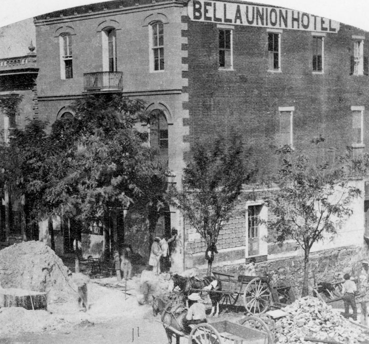
Note 2: The following photo is more apropos being from the correct period. The Bella Union Hotel had roots back to the 1830s. The Wikipedia page has some of the history. 

This is east of Temple and Main Streets. Temple runs up into Bunker Hill West. 

Remarks: Modified: 12/23/2025

12/23/2025 --


Thursday, March 3, 2016

Trails west

In 2014, we did some research related to the origins of Gardner, OR. An article in The Essex Genealogist (TEG, v 35, no 2) and The Gardner Annals (TGA, Vol II, No 1) provided details about the ship (barque Bostonian) that wrecked at that site, its owner (Henry D. Gardiner), and some genealogical information. Henry was a descendant of George of Rhode Island, but his wives were descendants of Thomas of Salem.

Prior to the time that the ship left Boston, it had run up and down the east coast and points further. In the same year of the shipwreck, the Bostonian had been New Zealand.

Last year, Philbrick's book about the whaling ship, Essex, that was out of Nantucket, was made into a movie. Recently, I read the book (only saw the preview of the movie). I don't know if the movie went into the cannibalistic events, however they are described in Philbrick's book. This gives one pause or ought to. But, we'll not go further into the subject. The book is exemplary due to its attention to detail plus to its copious notes.

However, there are some humorous notes. Philbrick talked about the loading process that preceded the voyage. Too, the crew had to be put together. Of course, Nantucket'ers were preferred but scarce. So, they had to cast a wide net to get the manpower. As you would expect, many on the crew would be newbies (tenderfoot out west - see below). Philbrick writes about the Captain having to be out on deck during departure so as to direct the crew. And, it sounded like it could be like Keystone Kops. So, embarrassing to the old salt.

You see, everyone on Nantucket would know when a ship was leaving. And, they would all be down to watch the spectacle. Now, a ship in full sail and under control is a sight to behold. Yet, that would not be the case. And, Philbrick wrote about the Captain being aware that those with long-glasses could watch the going-ons for a long while until the ship was out of sight.

The book is a good read.

Now, on another subject, the Bostonian went from Boston to San Francisco in 1849. It left in July and arrived in January 1850. That was the long way to S.F. by sea (if it were the only one open to the flower children, 1967 would not have happened). Another sea method was to go down by ship to Central American, cross over, and then back up the left coast by ship. That required two ships, at least. The journey across Central America was arduous. Also, there were things of concern, such as diseases, thieves, and other perils. Many lost their fortune on the way back after having found success in California's gold mines. Some disappeared.        

Henry D. Gardiner (and, Gardiner, OR)

---

But, there was another way to the west coast: moving oneself over land. Last year, we looked at Gardner, KS. Some say that it got its name from the Governor of Massachusetts (Henry Joseph Gardner - descendant of Richard of Woburn) at the time that a group of New Englanders came to the area. They founded Lawrence, home of KU.

Gardner is not far out of Independence which was the starting point for the trails. They were together until west of Gardner. Then, the Oregon (California) bound wagons went by Lawrence on their way west. The Santa Fe trail headed southwest.

One thing to note is that from Independence, MO to Fort Larned, KS, nowadays, can be done by car in the matter of hours. It is a little less than 300 miles. A lot of it can be done by Interstate Highway. Back in the days, the wagons took three weeks (as in, 21 days) to do that trip. And, it was constant work every day.

On the trails west were Thomas Gardner descendants. Many people stayed at locations that they passed. That was how some cities grew. All along the trails, we find little cities where people decided to stop and grow roots. The advent of the transcontinental railroad (1869 - last spike) saw the same sort of phenomenon.

There was another trail, though. That one was related the western movement of the Mormons from the area of Nauvoo, IL to Utah. Again, many of these travelers were from New England.

---

Why the interest? I have run across several diaries (published) from the time that we can look at in more detail. Many of the diary writers have ties back to New England and its roots. We have had an interest for some time to map out movements west. Some families have described movement to the south, first (Carolinas), before the western thrust.

Too, though, there are always reminders. New Mexico, as a State, was 100 years old just four years ago. It is one of the late comers in terms of statehood. But, it is a very old culture.

Coronado was there and in area of present-day Kansas, in 1541. That was long before there was New England activity. As we get toward the 400th, we will see lots of interest in regard to all of the different places and cultures that make up the current populace's history.  

Remarks: Modified: 06/24/2022

04/02/2016 -- Map showing Gardner Junction and the split of the trails west of Gardner, KS.

06/17/2016 -- More on trails.

07/16/2016 --Gardner's Beacon, Vol. VI, No. 1

08/13/2017 -- Posts on Lawrence (and surrounds): Trails West, Westward Ho, Blogging and such, Final Migration, Thomas Wentworth Higginson, Kansas and Lawrence.

08/07/2020 -- In this post, we are looking at two disparate spots that share a name, however there are many points in-between. Like Eudora, KS. Where "The Wakarusa meets the Kaw" is on their history site and is an example of local lore getting some attention. See "Along the Western Trails."

06/24/2022 -- Updated links to Eudora's website as topic continues to be of interest: A Ride to Kansas. 


Saturday, June 11, 2016

Westward Ho

We already had the 200th of Lewis and Clark's venture west. They came through near where I was recently and spent three days resting and getting their supplies in order. Kansas created a park at Kaw Point to commemorate the event. Other locales established memorials over the length of the Lewis and Clark trek.

Coming up then, too, will be 200th anniversaries of the great migration to the west.

We will be doing more posts on this for several reasons. For one, a major point in the trek was the split at Gardner Junction where the Sante Fe trail went south and the Oregon trail headed north. For a long while, the Oregon and California trails were the same. Then, out west, some wanted to go to sunny California and the Spanish architecture. Others wanted to go to the gloomy north. 

Go spend some time in Seattle to see what I mean. Nice places, though.

Then, too, plenty of Gardner and related families came through this area venturing either way. We will get stories of these families and their ordeals.

A little further south, there was another set of trails that came out of Arkansas heading west. 

One important thing to remember is that even in this eastern region of Kansas, wagons had a problem fording rivers (say, the Wakarusa). For instance, near Lawrence, they had to dismantle wagons as much as they could in order to get the things down the cliffs and over to the other side. Of course, similar efforts were required for the wagon contents.  

Consider, if you would, what was coming up for these folks as they went further west and experienced the terrain found in present day Wyoming, Utah, Oregon, and, even, Idaho.

Major work. Every day.

Do we ever think of that as we buzz down General Ike's (BTW, a Kansas boy) roadways - our current Interstate system?  

Remarks: Modified: 08/16/2025

06/17/2016 -- More on trails.

07/16/2016 -- Gardner's Beacon, Vol. VI, No. 1

11/01/2016 -- On foot traverse.

08/13/2017 -- Posts on Lawrence (and surrounds): Trails West, Westward Ho, Blogging and such, Final Migration, Thomas Wentworth Higginson, Kansas and Lawrence.

08/16/2025 -- Mentioned this topic in a look at the comparative flow of American Rivers. We will look at this topic further as an example of two roles of rivers: means of transport; barrier as was seen on all of the trails. 

Tuesday, January 18, 2011

Two cousins

The descendants list for Thomas and Margaret holds a lot of potential stories, from the early times onward. As mentioned before, we want to look at some of these before coming forward with Dr Frank A.'s tree (RD, et al). In some cases, we have separate lines merging back together.

So, we can talk about the meeting of two cousin lines. The first of the cousins, General Adolphus Greely (ancestors) is from John and Sarah (Gardner) Balch through their son, Freeborn. After serving in the Army in the Civil War, he became an explorer. He led, as a First Lieutenant, the Lady Franklin Bay Expedition (1881-1884) that found itself stranded because of the inability of supply ships to reach their location. There were follow-up attempts, but his wife succeeded in her efforts to keep the interest up. What was left of the team was rescued by Admiral Schley.

3 -- Coffin, 22 -- Greely
July 1884, USS Thetis
Now, the second of the cousins commanded one of the rescue vessels. He was Captain George William Coffin (ancestors). He is a descendant of Richard and Sarah (Shattuck) Gardner through their son, John. George was a US Naval Academy graduate and spent much of his career at sea. For the rescue, George captained the HMS Alert which had been lent to the US by Britain for the specific purpose of the relief mission.

Needless to say, the Schley attempt was successful, as one descendant, of Thomas and Margaret, came to the aid of the other in an event that was five generations removed from the early times.

Remarks:

04/18/2023 -- While researching Donner Pass and the California Trail, we ran into Horace Greeley's writeup of his trip west in 1859. ... He shares an ancestor with Adolphus. Also, here is the Naval Career for Capt. George William Coffin. 

06/03/2021 -- Sir Franklin had been in the area in the 1840s while looking for the Northwest Passage. He and his crew disappeared. In the 1850s, a rescue attempt was made that included the ship, H.M.S. Resolute which got stuck. It was abandoned and discovered later by a whaling crew. And, the Resolute was returned to England. Queen Victoria had its timber used for ceremonial furniture. A desk in the White House was one of the pieces.  

02/18/2018 -- Written seven years ago, when I was still a newbie. Such as, I didn't know the different towns of Essex County. I had to wonder what North Shore meant. In the western part off the U.S., towns are far apart. What is it like to live cheek to jowl with your neighbors? 

10/31/2014 -- AnceSTORY archives (02/18/2018, this blog is no longer around).

07/06/2013 -- While researching for Gardner's Beacon, Vol. III, No. 2, I ran across this photograph (Wikipedia) that has both of the cousins in close proximity on the USS Thetis. The team lost several men (there is another photo of the team in 1881), but there were some accomplishments. For instance, a new farthest north was attained by two of the members: 83°24′N 40°46′W.

05/21/2011 -- Sarah (Gardner) Balch.

Modified: 04/18/2023

Friday, August 7, 2020

Cumberland Pass

TL;DR - East and west has to be our scope; that is, the totality of the American experience over the four centuries.  Oh yes, a mountain named Harvard. It's in an out-of-the-way place but close enough to Cumberland Pass, in the Rockies. There is another pass in the east through Cumberland Gap. Some went through the eastern pass on the way west; in those days, the travelers would have skirted those higher area as the travel was hard enough without needing extra thrills thrown in, as we see now with technology providing the facility for frivolity.

--

This is a little diversion, related to western movement: 3 trails, Final migration, and more. We have two passes out of many that those migrating west had to handle with a similar name: Cumberland Gap and Cumberland Pass. The former was a training pass out of North Carolina, associated with Daniel Boone leading people west. He ended up in Missouri, early. The latter represents much higher elevations (11k more feet). Fortunately, even out west, there were choices found that alleviated some of the agony of the work required in those days. One consequence of moving was that record keeping, many times, lagged seriously leaving gaps, many times filled with effort but also becoming brick walls.

We wrote of Cumberland Gap, earlier. The pass through this gap allowed movement toward Tennessee and Kentucky and then all points west. Even with a height of a mere several hundreds of feet, traversing the gap would have required arduous work. The use of 'training' suggests that anyone starting out with this pass on the way to Oregon still had lots work to accomplish of a type of daily grind.

Also, quoting Wikipedia:
  • The passage created by Cumberland Gap was well traveled by American Indians long before the arrival of European-American settlers. The passage through the gap was originally created by herds of woodland buffalo that traveled across it over thousands of years, drawn by the abundance of salt in the region. The earliest written account of Cumberland Gap dates to the 1670s, by Abraham Wood of Virginia.
Now, the other pass? It's in the Rockies, in Colorado's Gunnison County, to be specific. Now, this pass was not on any of the major trails that were heavily used. For the most part, there were easier passes (comparatively, to each other, but still requiring hard work, endurance, and carefulness) for those who were heavily laden. Taking a look at passes on the Oregon Trail will give some idea of this.

Cumberland Pass is in the Sawatch Range. Tincup CO is on one side of the pass; on the other side is Pitkin CO. Both of these are mining towns which is a type of pioneering effort. For the past few months, we have been looking at pioneer families which is why Cumberland Gap was mentioned. Then, we remembered the other Cumberland pass. Both are named for Prince William, Duke of Cumberland. Both too show the influence of England and New England.

For instance, Mt. Harvard is in this range which includes several mountains that are over 14k feet in height. One interest in this area is that it pinpoints the Continental Divide. As the map shows, with the Mississippi's drainage, we had people leaving the right side, heading to the left. Not only were there rivers to cross, each had many tributaries of various sizes.

So, this pass in Colorado is near where the flow changes. We will have a little more to say about rivers. We mentioned Gardner River which goes to the Pacific. This is further west and north of Cumberland Pass where the Snake (Columbia) and the Gardner River (Missouri) start, ending up in two different places.

The watershed of the
Mississippi River
cut the land through
which the pioneers
had to travel.
With regard to the 'training pass' mentioned above, we noted in a post (Final migration) the report of the group who left Massachusetts and traveled to Kansas. They founded Lawrence (and KU) among other things. But, they mention coming out of the Kansas City area on foot, camping by the Wakarusa, fording it and getting to what became Lawrence. As has been noted, this little river required techniques that became handy in the western mountains: tear down the wagon, lower, get it across, and back up, reassemble, gather everything that had been ported across. Time and again.

This map is to suggest how many times that sort of thing would have been necessary. And, storms, snow run-off, and such would have made crossing turbulent waters part of the concern. So, no interstates and air-conditioned cars. Too, follow the North & South Carolina line to Oregon (lower right to upper left - almost diagonal).   

Note: In the movement west, official recordings always trailed (lagged behind) the edge of the wave. How long this happened varied? There are lists that show when each location started to get regular in recording but that as elastic, too. Never did it just pop into place overnight. There would have been a transition period. So, genealogists with their lead feet? Oh yes, they like to talk as if their need for a document gives being to the ancestors of people who might have, now, holes in their paper trail. Guess what? That is categorically stupid (even Bayes would agree with that). So, what to do? Get more clever about filling in the pieces. Do this without due diligence? No, just stay out of the way and let the story be told as it is pieced together.

Remarks: Modified: 06/24/2022

08/07/2020 -- In this post, we are looking at two disparate spots that share a name, however there are many points in-between. Like Eudora, KS. Where "The Wakarusa meets the Kaw" is on their history site and is an example of local lore getting some attention. See "Along the Western Trails."

08/08/2020 -- Cumberland Pass in the west has the same name as that in the east known as the Gap. However, they represent the movement across the country which established the country. So many stories. Too, they created instances like poor Chloe being dissed by Plymouth people squatted in eastern Massachusetts. It's a large country out here, folks. So, I have now seen oodles of families with the same problem from the tip (Canadian border) all the way to the lower part of Texas. Has anyone really awakened to this? Not that I can see, otherwise I would not have the need for this type of post (Genealogy and Bayes).

08/08/2020 -- Following up on the theme of the difficulty of the cross-country trip, here is another view which is the Google-planned trip from North Carolina to Oregon. The little insert is a map of the Oregon trail which went through Gardner, KS. Later, the travelers went up the Missouri to where Omaha is and then ventured west meeting up with those who came out of Independence, MO.

Modern route,
courtesy of Google Maps
It is interesting how the modern highway system matches up with that the people settled on guided by those who had traveled trail. Reminds us of Jedediah's mapping of the California Interstate System.

08/28/2020 -- Having been researching some of the families of the frontier, it looks as if we ought to pick some as archetypal. For now, let's use Boone and Pike.

02/27/2021 -- Changed to using American Indian. 

06/24/2022 -- Updated links to Eudora's website as topic continues to be of interest: A Ride to Kansas. 
               

Wednesday, May 1, 2024

Old L.A. and the U.S.

TL;DR -- We continue to look at CA via two cities in order to learn more about the Spanish period that preceded the entry of New England's influence into the area. Period photos are the enabling technology. 

--

We have been looking at two CA cities, LA and SF. Early on, we had Jedediah Strong Smith representing the eastern culture in his wanderings across that country. He was there in the 1830s. Later, we looked at the Butterfield Express which brought people, goods and mail from St. Louis, MO and from points in between, such as TX and AZ, to LA and onward to SF. This was in the 1850s and was quite successful despite the arduous nature of the trip. However, the Civil War interrupted the business for a few years, but post that conflict things boomed again. 

There were several motivations for looking at this area of the country which include the early explorations when it was a territory of Spain, then the initial comings and goings by sea and land, the acceleration of the New England influence after the Civil War, and, in particular, an area of DTLA that was known as Bunker Hill. As we have mentioned, it now is full of sky scrapers (high-rise corner), but the area represents changes that were fast and furious over the years. However, a huge change was the introduction of the railroad across the country. We can read of this: Samuel Clemens took the trip by stage coach; later, R. W. Emerson took a similar trip by rail. Clemens disliked the journey so much that he returned to the east coast by sea which was no mean feat either.  

W e have mentioned, before, the Cathedral (St. Vibiana's) that moved from the base of Bunker Hill to being on top in the latter part of the 1900s as urban renewal took its toll. The older building still stands, near the LA City Hall and serves the function of an event center. Today, we saw an early photo which was from before the time that the Cathedral was built. It is a smaller Catholic church with an interesting history with respect to our continuing studies of the other colonial experiences in the founding of the U.S.  

Before going further, let's pause to recognize and honor the work of the Water and Power Associates (WPA) which has collected photos related to the history of Los Angeles. This is their mission statement: 

to inform and educate its memberrs, public officials, and the general public on critical water and energy issues affecting the citizens of Los Angeles, Southern California and the State of California.

The below photos and information are courtesy of their virtual museum and collection of period photos. 

---

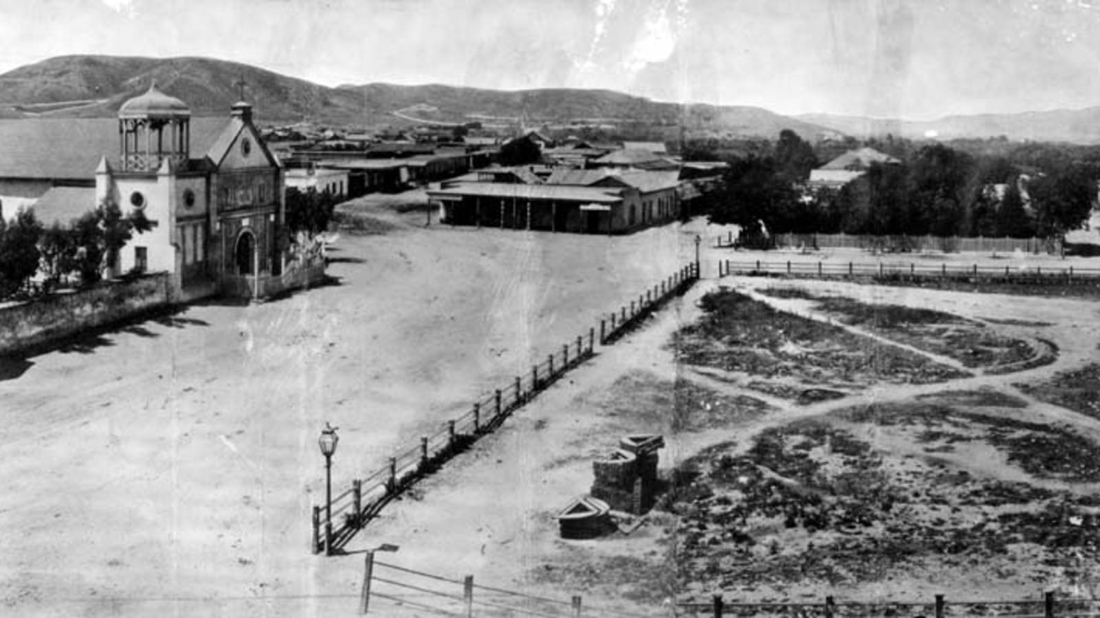
We start by looking at an earlier church (La Iglesia de Nuestra Señora la Reina de los Ángeles - Wikipedia). It is on the left of this photo that looks north on the Calle Principal which is now Main Street (Wikipedia) and which has been mentioned many times. We can consider the area to be at the foot of hills to the west of DTLA such as Bunker Hill. 

Old Plaza Church 

Zanja Madre
The caption for the photo at the WPA site mentions the "Mother Trench" (Wikipedia) with this caption:

The "Old Plaza Church" facing the Plaza, 1869. The brick reservoir in the middle of the Plaza was the original terminus of the Zanja Madre.

As mentioned, LA is a very dry place. So, water was brought in early and has continued to be of concern as the population abounded, and still abounds, almost without bounds. 

But, in the beginning: 

The Pueblo de Los Angeles was an official settlement of Spain. They had three types of settlements in Alta California: presidio (military), mission (religious) and pueblo (civil). The pueblos would provide the commercial and agricultural needs of the military as an alternative to the missions. (source Wikipedia) 

When researching Jedediah's experiences, we looked briefly at the military aspect of the community. The Old Plaza Church and St. Vibiana's are examples of the religious. In some of the early photos that we show below there were other churches appearing as New England's influence grew. But, for now, let's look at travel and trade, again. Butterfield is mentioned in one of these photos. 

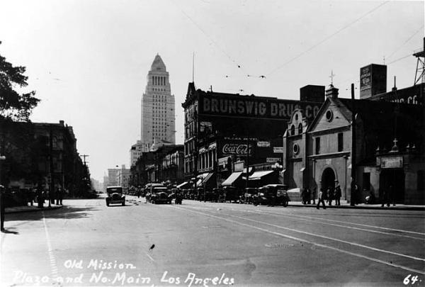
Old Plaza Church
and the LA City Hall

In our earlier look, we mentioned how his coaches came into the area where the Times-Mirror building is now. Let's use a photo of Main Street looking south to set the dimensions. The photo is from 1928 which was not long after City Hall was finished. We see that the civic building is just down the street from the church. 

And, the facilities used by Butterfield (and his cohorts) would have been just on the other side of the City Hall from the church. 

Quoting the WPA site: 

The Overland Mail Company operated by John Butterfield (the founder of American Express) rented space for a station until it built new quarters in 1860 at Second and Spring--the present location of Mirror Building. The Wells, Fargo and Company also had their office here and Phineas Banning (Wikipedia) operated coaches to Wilmington and San Bernardino from the hotel.

But, that brings up another view to consider. We will be looking more at the history of Bunker Hill, eventually. It is just south of Fort Moore Hill which is in the background of the church in this photo. From this perspective, one can see why there was an effort to tunnel through these hills to go west. 

Fort Moore Hill to 
the west of the 
Old Plaza Church

The PWA site on Fort Moore hill: 

Fort Hill (also known as Fort Moore Hill) was a prominent hill overlooking the pueblo of Los Angeles. Its commanding view of the city made it a strategic location.

Fort Moore was an historic U.S. Military Fort during the Mexican–American War. Its approximate location was at what is now the Hollywood Freeway near the intersection of North Hill Street and West Cesar Chavez Avenue, downtown. The hill on which it was built became known as Fort Moore Hill, most of which was removed in 1949 for construction of the freeway. The hill was located one block north of Temple Street and a short distance south of present day Cesar Chavez Avenue, between the Los Angeles Civic Center and Chinatown.

The fort is now memorialized by the Fort Moore Pioneer Memorial, 451 North Hill Street.

----

Now, getting back to Butterfield, the building where he started was built in 1835. That is very early as the area was still under Spanish control. This next photo is from 1865 and shows the state of the building after additional floors were constructed. 

1865 view after
addition to 1835 building of
Isaac Williams (Wikipedia)

Quoting the PWA site: 

The Bella Union Hotel was considered the first hotel in Los Angeles. It became the Clarenden in 1873 and the St. Charles in 1875.

Constructed in 1835 as the home of Isaac Williams, a New England merchant who moved to Los Angeles three years earlier, the one story adobe became the last capitol of Alta California during the Mexican era when Governor Pio Pico purchased it for his office.

After the conquest of Los Angeles by American forces in 1847, the building was used by Lt. Archibald Gillespie, who commanded the occupying forces. Later it housed American troops, and after they left, it became a saloon. By early 1850, the building was operating as the Bella Union Hotel. Later that year, it became the county's first courthouse and beginning in 1858, it was the region's transportation hub. The Overland Mail Company operated by John Butterfield (the founder of American Express) rented space for a station until it built new quarters in 1860 at Second and Spring--the present location of Mirror Building. The Wells, Fargo and Company also had their office here and Phineas Banning operated coaches to Wilmington and San Bernardino from the hotel. 

Wikipedia quote: 

On October 7, 1858, the first Butterfield Overland Mail stagecoach from the East, arrived 21 days after leaving St. Louis, Missouri. "Warren Hall was the driver, and Waterman Ormsby, a reporter, the only through passenger. In that era it was the region's transportation hub: Wells, Fargo & Co. and Phineas Banning's coaches to and from Wilmington and San Bernardino had offices there.

By way of comparison, the Sante Fe trail went from Independence, MO through Fort Larned, KS on its way to NM after passing through Gardner, KS. That trek, western MO to western KS took three weeks of hard work, daily. The coach trip took the same. Mostly, the horses did the work. However, think of the difficulties of the trip compared to our modern times and its highways. 

Isaac Williams is an example of the multifaceted gents who were into fur searching, trading and then ranching. Earlier, we looked at William S. Bent, New Englander, and his adventures in the middle of the country; he was a cohort of Kit Carson and others. Williams was close to the same time and followed Jedediah Strong Smith out through the Mojave Desert to the lower coast.  

Connection: One owner was Obed Macy (WikiTree) who was a Thomas Gardner descendant of a Nantucket Island family. 

---

Let's do one more photo as the three-story building that started as the Bella Union Hotel (Wikipedia) and became the St. Charles Hotel was there for a long while. And, it has a storied history that needs some attention. We will look more closely. The Daily Mirror sent an artist to visit the St. Charles and published a sketch March 16, 1936. It was demolished in 1940. 

As well, we will look at Bunker Hill houses and other buildings and identify those built by New England families. There are many photos to browse through which show the houses to be quite demonstrative of culture and money, considering the problems of LA and obtaining building materials. In one case, a mansion was converted to an apartment hotel and operated for years. 


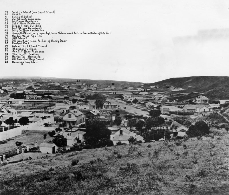
Labeled photo, 1869

This photo is from one end of Bunker Hill which sweeps around to the right. It mentions the Times building and the "old" Overland Stage Corral. The Civil War interrupted the flow of traffic. This was several years after that conflict. Notice that the 3rd Street dig for the tunnel had already started. 

---

So, as grounding or control, here is a modern view of the Bunker Hill area and its surroundings from Kenneth Hahn State Park (Times article). 


May human curators reign for a long while. Thank you, Power and Water Associates. 

Remarks: Modified: 12/23/2025

12/23/2025 -- More on the Butterfield stage as representing the U.S. government's concern for handling Overland Mail. There has been lots of research about the trail from St. Louis MO to San Francisco CA.