Showing posts sorted by relevance for query bunker hill west. Sort by date Show all posts

Friday, October 3, 2025

Bunker Hill West - 1873

TL;DR -- Today we saw an old photo of a sketch which shows part of Bunker Hill West in the 1870s. That's early enough to be before lots of the changes introduced over the long span of US history. The English culture took over in 1847 from that of New Spain. And so, the area has lots of offer with respect to our interest in the long reach of New England. 

-- 

Here we go with a post on LA, again. Yesterday, as we looked at New France and New Spain, we mentioned Bunker Hill West. In the early days, the hill overlooked bustling LA. Then, people built upon the hill. They tunneled under it to start to build on the other side. It was partly lowered starting in the 1960s. Now long after, the skyscrapers started to appear with the first one right by the Library which is about as old as the LA City Hall. 

This pointer is to a search on Los Angeles within our blog. There may be Bunker Hill posts that did not come up on the list. In any case, the below photo which is courtesy of the Water and Power Organization of Los Angeles, CA is from a sketch near what is now 9th Street looking north. To orient the view, the well-known City Hall is between Spring and Main Streets (shown converging here) eight blocks north above 1st Street. 

To the middle below the foothills is where one would find The Cathedral of the Angeles, not built yet. The train station is north of that. 

Of interest today are the hills on the left. If one follows the Fort Street line (left of Spring Street) up toward the hills to north, there is a building standing above the city. That was Fort Moore. Going to the left, one can see parts of Bunker Hill West. 

Prior posts had some information about the history of development of the hill. Today, we wanted to show a view indicating that there was a hill of size. According to Wikipedia, the elevation was up to 200 feet above Los Angeles. Naturally, there are higher hills including the massive 14k-foot  mountain within a morning's drive seen on the upper right. 

The Bunker Hill represents history, pre-US and post the events of 250 years ago. In this area, the culture changed several times in a manner that is representative of the changes in the US. The current stature of Bunker Hill is obvious in the photos of LA. The majority of the skyscrapers have their footing on the scraped down and leveled heights of the hill. 

---

Caption of the photo: (ca. 1873)* – Panoramic sketch looking north toward downtown Los Angeles showing mostly undeveloped land.  At lower-right can be seen the junction of Main and Spring streets at a point where 9th Street will one day intersect.  Hill Street and Fort Street (later Broadway) are on the left.  The Verdugo Hills and snow-capped San Gabriel Mountains can be seen in the distance. Photo of a lithograph, courtesy of the California Historical Society. 


DTLA, 1873 

We are fortunate to have original photos, sketches, and paintings of the area. One hopes that these photos with provenance continue to be available in the age of mimic and copy in a manner that does not preserve the truth of the matter. 

But, that's a technology matter to be discussed further with an actionable focus. 

Remarks: Modified: 12/23/2025

10/11/2025 - Water and Power has a whole page of photos from Bunker Hill West from the 1930s onward, including many areas compared with photos from then and now. 

12/23/2025 -- More on the Butterfield stage as representing the U.S. government's concern for handling Overland Mail. There has been lots of research about the trail from St. Louis MO to San Francisco CA. 

Saturday, April 26, 2025

Bunker Hill of early LA

TL;DR -- DTLA is known for its forest of scrapers clustered on or near Bunker Hill West which is an example of the influence of New England. The rise of fakery, such as we see with GenAI/LLM, has put more importance on existing photo caches that carry historic value. So, we show some early scenes from LA which underwent several transformations in a little over 100 years. But, using the Bunker Hill area, we can pinpoint a few instances that are of value to history. 

---

In our research of the expansion of the U.S. during the times of COVID, we referenced the commercial aspects of overland travel several times. That was mainly to carry mail, commerce and people. Of the activity that we looked at, we always found New England connections. 
  • St Louis MO to San Francisco CA - this was pre-Civil War. Our post showed the schedule and the route. From that research, we looked at several things including the people involved, early LA, the route itself, and more. 
One of those connections was that in hilly Los Angeles, the downtown itself early on nestled under hills. One of these was given the name of Bunker Hill West and have had many posts. Old L.A. and the U.S. is an example. In that posts, one of the images was a very early photo which was of the area where the Overland Stage came in. Times Mirror (old employer of John) came to be in that area, too. There are other connections related to New England families who came out and developed the area. 

These photos are all from the 1860s and shows that phase of the development of LA. Bunker Hill West? It is where all of those skyscrapers now sit, upon a hilly area that was leveled. In the period that we will look at, the hills were first tunneled under so that there could be regular traffic (days of horse power, but commerce was increasing as was the population). 

Today, we saw a colorized copy of a photo provided in the "Old L.A. and the U.S." post. The photo is next. All of the subsequent photos are from the same source (Water and Power Associates) which we will do another post on, especially now that we have GenAI/LLM trashing the internet. 

Taken from Poundcake Hill
On the right, we see part of Bunker hill
1868 - colorized

Now, this photo has the legend of these building which are numbered. "65" labels where the Overland activity took place. This area was a stopover both ways, the St. Louis route went to San Francisco and back. 


The following photo is of the same area, but it is from a position on Bunker Hill West. From Poundcake, one would have gone to the right to Bunker Hill and then taken a few steps along the hill. Again, there is a legend. 


Now, the next photo shows the same area, but off the hill, in the 1870s. The first high school had been built which sat upon Poundcake hill.  

High school (with the tower)
on Poundcake Hill
1878

In our next posts, we will look at the end of the Mexican era which corresponds with the arrival of Jedediah Strong Smith. New Spain was in the region long before this time. The earliest involvment of New England can be associated with the Bella Union Hotel. An adobe structure was built in 1832 and was the residence of the New Englander. The building was also an office for the Mexican government. By the time of the Overland Stage, it had built up to be used for office work. 

We have mentioned the hotel and offer this map from 1871. Being an illustration, it doesn't show the contours and limits of Bunker Hill West, but one can see how LA was in a valley and had a agriculture focus. Streets were established early; this scene shows Main and Spring as they come in from the countryside and meet where the LA City Hall now stands (built in the 1930s). 


Both St. Vibriana's and the Old Plaza Church are prominent by this time. Where the roads end at the green hills (idealized presentation), now we see the DTLA scrapers nestled along several blocks as they sit on reduced hills.That accomplishment, itself, is worth some attention as well as the attempts at bringing water into the area. 

But, the main focus will be the transitions through time by culture and the artifacts (buildings). LA is unique in having such speed of alteration. 

Remarks: Modified: 12/23/2025

12/23/2025 -- More on the Butterfield stage as representing the U.S. government's concern for handling Overland Mail. There has been lots of research about the trail from St. Louis MO to San Francisco CA. 


Monday, February 19, 2024

US, examples, LA

TL;DR -- Los Angeles is interesting in so many ways. This post pulls some thoughts about what is known as Bunker Hill West which is in the heart of the downtown area that many do not remember. 

--

This is another of the posts about Bunker Hill west which included a few, such as New England, in LA. As mentioned earlier, the first of these was motivated by looking at Butterfield and his relationship with the Mirror Company. The Los Angeles Times was a product of a later version of this company. Their building was emptied when the LA Times ran up north to be valley people. Now, its fate is being discussed. 

Luckily, the LA City Hall and some of the associated buildings are still there. We show a photo comparing to eras below. First though, near where the City Hall is now there was a Cathedral (St Vibiana) which was moved. As a reference, there was a post (Lost Angeles, again) that contained this real early photo of the area.  

St. Vibiana, 1885 

The area of the old cathedral and the city hall might be considered as at the eastern foot of Bunker Hill (west). US 101 runs right by there. Too, the whole area was rearranged a few decades ago. One result was the Dodger Stadium was built. Skid row was move several blocks over to the east toward the railroad. Fortunately, the old LA Train Station was spared. 

The story is well documented. What we have coming to fore are photos from people that can help us preserve the history. Case in point, the following image shows two photo from about the same location. One is from the 1950s and shows the LA City Hall in all of its glory. 

Two views of 
Bunker Hill West from 
the northwest

The later, bottom view is more recent. Some of the buildings are the same. But, the City Hall is now obstructed in the view, except for its tip. The low, flat building in the foreground? That is where the St. Viviana Cathedral was moved to. We will get back to the architecture and positioning. But, it is right at the corner of US101 and I110. Pan around to the right, and one will see the Cathedral of the Lady of the Angels. Too, the high rises of Bunker Hill will come into view. 

A prior post had this photo, which includes the LA City Hall, taken from the southeast. 


Those building are an island of high-rise in a sea of extended development that turned into the sprawl of LA. We have this photo for that, too, that bears some discussion. LA's downtown and Bunker Hill West is visible on the upper right.  


This view shows I110 pacing through the sprawl from its interchange with I105. 

Remarks: Modified: 02/19/2024

02/19/2024 --  

Sunday, June 22, 2025

Bunker Hill, II

TL;DR -- The Siege of Boston continues until March of next year. This past week, there was an effort by the British to dislodge the patriots (or provincials as known in London) which didn't work. We will have to look at what the next nine months entailed for both sides, in MA and elsewhere. Speaking of which, "Bunker Hill" has been used a lot in naming over the 250 years. We compare the MA one with that area in DTLA with the name, again. But, will look at some others, ,worldwide. 

--

Right now, we are in the period that was associated with the Battle of Bunker Hill with a main skirmish happening on 17 Jun 1775 with the first piece of the action happening at the locale of Lexington & Concord in Apr of 1775. Bunker Hill Day is a regular holiday in Boston on Jun 17th. 

At this time, in 1775, the British were still surrounded. The Siege of Boston continued. The next day of commeration will be the Evacuation of Boston that happened on 17 Mar 1776. 

As we mentioned, the Massachusetts Magazine had an article on the troops that participated in this Siege with some information about the officers. There was an article in every issue, 1911 to 1918. 

And so, we will look at events and people over the coming years as the 250th lookback unfolds. 

----

May we change gears? Bunker Hill is a little over 100 feet high and is in the Charlestown neighborhood. There is a monument for the event on Breed's Hill which has a lower elevation and where most of the activity took place.

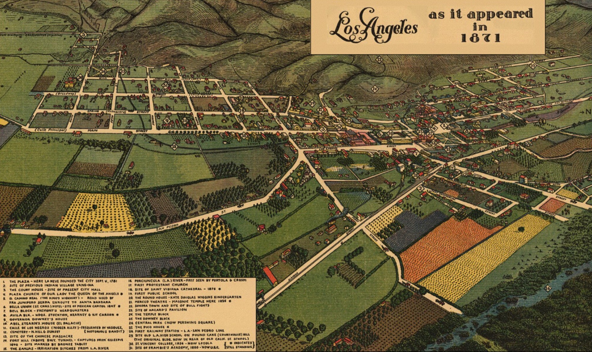
At the time of the Battle, the British owned the waters as Boston was across the Charles River from where the Battle took place. The whole affair is quite strongly resident in the American mind. In fact, Bunker Hill has been used as a name in many places. We will look again at Bunker Hill West which is in Los Angeles and about which we have had several posts. Today, we look at the lay of the land. 

But first, here is a London map of the situation in 1775. 

Printed Aug 1775, London

Before transitioning to the west coast, we have to mention the last surviving veteran of the incident: Ralph Farnham (1756-1860). He is of the upper part of Massachusetts now known as Maine and is cuz as are many. We will look at him, again, as the whole of the Maine experience needs more attention partly due to the case of the southern entity, Boston, was more prevalent in historical accountings. 
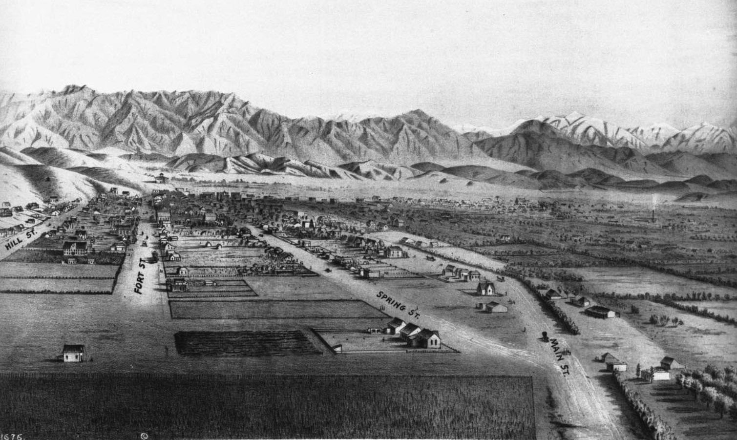
---
 
Now, 
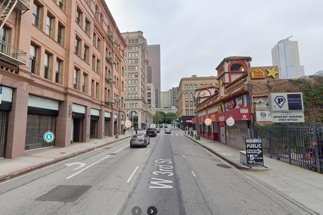
Bunker Hill West? The name has been used in many places: the 
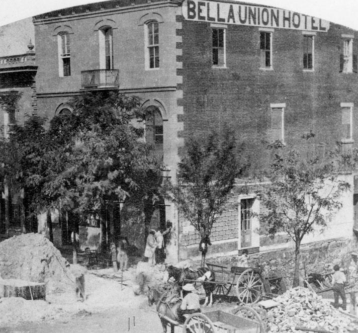
Wikipedia list. Notice that Los Angeles is on the top of the list. Our interest was first brought to the area as this is where the stage coach route from St. Louis arrived after an arduous trip down into Texas, across the souther border (wandering into Mexico), and then ending in Los Angeles. That was not the terminus, as with some refreshment of resources, the stage line then carried passengers and freight up to San Francisco. Where, the process started again on the way back to St. Louis. 

Mind you, folks, there are several things to consider: logistics (compared to the Pony Express, this was much more of an intricate maneuver; we are talking pre-Civil War however some of the western States had been defined (such as Missouri in 1820 - added along with Maine to balance the north-south  issues; in terms of Bunker Hill in DTLA (Downtown Los Angeles), though, the terrain was entirely different as we will be pointing out. 

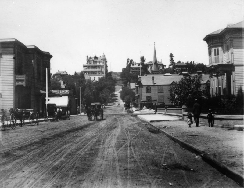
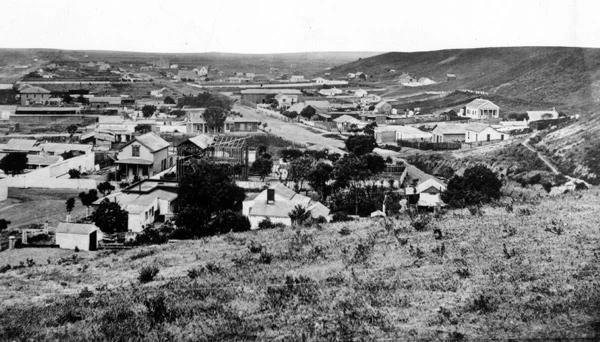
The lowest point in DTLA was about 59 feet. The hightest was the hills to the west with Bunker Hill (BHW) topping 350 feet. DTLA is many miles from the ocean. In terms of survival, being in a sheltered, inland cove with fresh water from the mountains would be more appealing than the environment now associated with being encrusted by salty waters. 

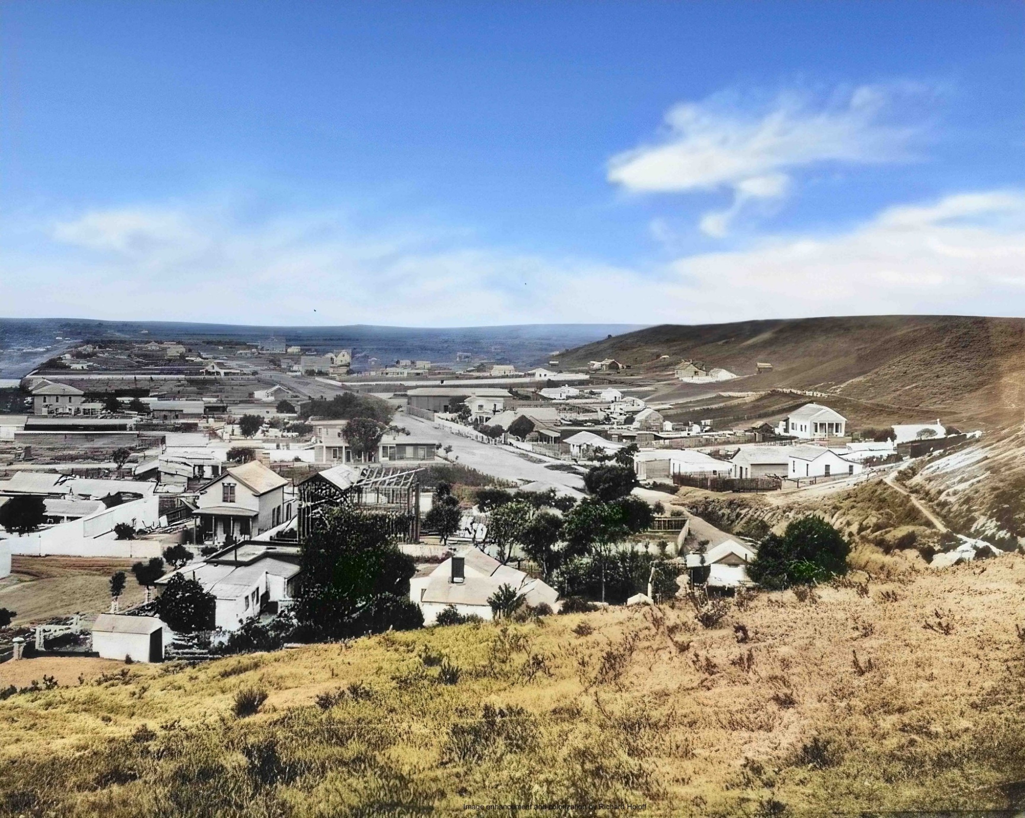
In the latter part of last century (post the 1950s), there was an effort to knock BHW down which seems to have been successful. They flattened the basis for the high rises that rose and that are now photogenic against the background of Nature's display of mountains. 

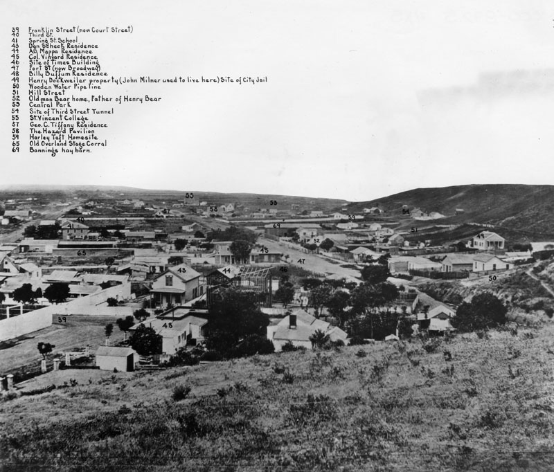
Here is an example. I marked three things. 1) On the right, the line points to where City Hall pokes its head up proudly. This 1937 building was the limit for heights until later in the 1900s. We can be more specific. There are early photos from Bunker Hill showing the top of the spire of the City Hall. 

Now is the time to mention one other thing. In the center, the tannish (round) building behind the white (square) one was the first building to penetrate the old limit. The developers used the opportunity of the LA Library having experienced arson and selling its airspace to get funds to recover as a means to start the trend that gave us the high-rise look. 


So, speaking of the Central Library, they recovered physically and bought replacement books. But, there was another instance of arson later. To me, on any of these photos, I look for the bank building and figure out where the library is nestled (having spent many hours there; across the street; the base of the bank building is on higher ground along the elevation of BHW). 

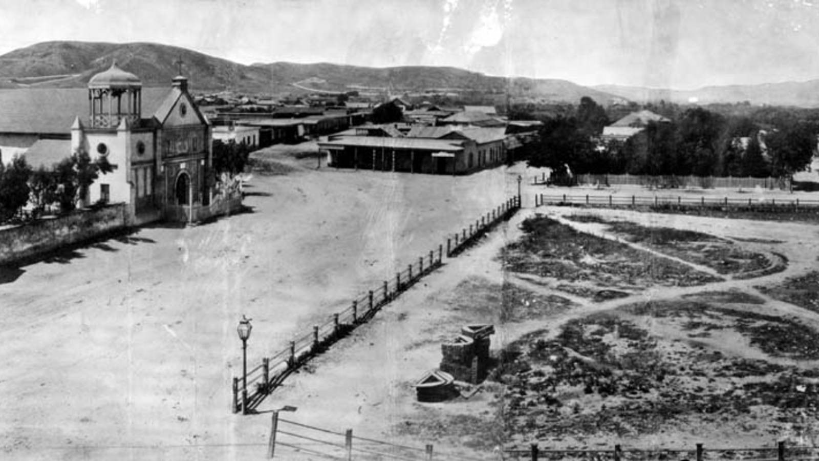
2) and 3) These have to do with old DTLA from the time of New Spain onward. In the middle, the text says that if we jump (or fly like superman) over the buildings we would find the Old Plaza Church. Several of our posts have photos of this building from various time periods. Yes, it was there when Butterfield came in with his stage line. In terms of the beauty of DTLA, the Train Station which is a remarkable example of SoCal architecture is across the street. 

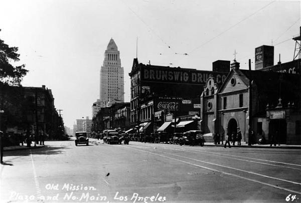
So, now we can consider another church. Not far from the Old Plaza Church and the City Hall is the structure that was St. Vibiana, a Catholic cathedral. That old building dates from the 1870s which is new from the west coast view point (reminder for those looking from the east). An earthquake caused some damage but not enough to destroy the building. It now is an event center of some note. 

The cathedral was moved to the left side of the photo where US 101 and the 10s intersect. We can figure out the lingo, but the area has been visited by tourists with many photos extant. This view shows the extent of the high-rise area. And, the larger buildings are clustered there at BHW. 

---

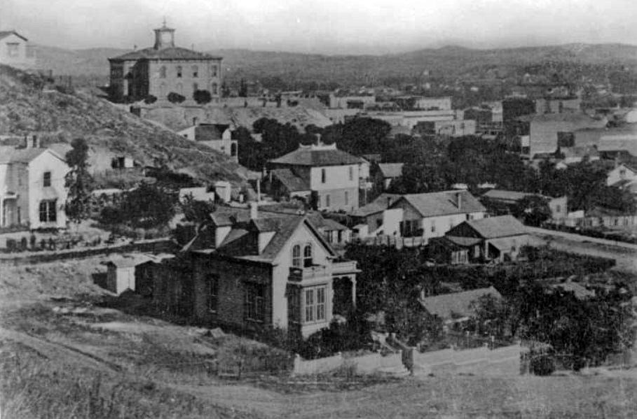
There are early photos (1870s) showing that people started to try to tunnel from the getgo. Several tunnels were completed with many still operational. As well, there were steps put up for people having to go up to the buildings on the BHW or over to the other side. And, the Angel Flight configuration of a rail car exploited the arrival of electrical power. Fortunately, through many periods of reconfiguration such as the scraping down the elevation, people saved the old mechanism which is now more of a tourist event rather than operational. 
 
---

What's next for looking at the namesakes of Bunker Hill? 

Remarks: Modified: 12/23/2025

12/23/2025 -- More on the Butterfield stage as representing the U.S. government's concern for handling Overland Mail. There has been lots of research about the trail from St. Louis MO to San Francisco CA. 

Sunday, May 18, 2025

Bunker Hill, I

TL;DR -- We're in the time of the Siege of Boston with the Bunker Hill incident on the horizon. But, the Siege went on until March of 1776. So, we have a few more items to look at prior to the hubbub of the Declaration of Independence whose inspiration was, in part, brought by kin from almost 100 years prior.  

---

Siege of Boston

The first thing to remember is that we are at the 250th of the Siege of Boston. Earlier, we looked at an event that led up to this: Lexington and Concord. This start of the turmoil on April 19th attracted support of able-bodied men in the area, except for Salem troops under the command of Col. Pickering (Where was Salem?).  

In our research, we ran into the battle of Bunker Hill (17 Jun 1775) early on through reference to Col. Thomas Gardner who was killed in that conflict. His 25th Continental Regiment was involved in several engagements. 

This brings up Dr. Gardner's look at the Regimental history through a series of articles that appeared in each of the issues of The Massachusetts Magazine. In the first article, he discusses the Siege of Boston and notes that the revolutionaries were not solely rebels. Many officers had served the Crown in early conflicts. 

The Siege was almost a year, going to March of 1776. We have time to look further with respect to our themes. 

---

Los Angeles (LA) of California (CA) has a neighborhood that is called Bunker Hill west. We have had several posts on the area which represents the history of LA from the time of Spanish rule to the current age of skyscrapers that have populated Bunker Hill West area. Early English involvement the area was in the 1830s. After that, many New Englanders showed up in the area. We have been researching this influx and have reported on some families. 

A stage line came into LA from Arizona (AZ) that was part of a freight/mail business with an eastern terminal at St Louis of Missouri (MO). Pre-Civil-War activity on the line followed a tight schedule and was supported by stops along the way through several current States, including Texas (TX). The area in LA where the line had their stop and supporting businesses, such as those that provided horses, stage maintenance, and more, was at the bottom of Bunker Hill West. 

The Butterfield Express, and many other Express companies, were New England in origin. Of interest is that many of these are still in existence. 

---

The Revolutionary War started in 1776 and went until 1783. So, we will have several years to look at this history in all aspects including families and their genealogies. So, let's remember Rev. John Wise of Ipswich, MA who was seen, almost 100 years later, as the inspiration for the document normally associated with the War, the Declaration of Independence. The Col. Gardner mentioned above was related to Rev. John through their Gardner lineage. Both are kin. 
 
Remarks: Modified: 12/13/2025

12/13/2025 - More on Bunker Hill, per usual. 

Saturday, December 20, 2025

Overland mail

TL;DR -- Bunker Hill West was on our sights early as we looked at the progress of New England's influence into the west coast. We noted that a coach company had facilities there and that the journey for some arriving had started in St. Louis and was going up to San Francisco. That route was covered in both directions. There is a group that has been documenting the company and its involvement. One of the investors was of a Gardner family. We went to look for information about him which we will report. This post is an introduction to Overland Mail as an initiative of the U.S. government starting early. 

--- 

As earlier posts mentioned, we used the isolation of the COVID times to pay more attention to the interior of the country. We got started with the naval activities, such as coastal attempts at colonies, fishing in the waters over here every year with the expectation of going back with some dried fish, and more. Too, the naval history of New England is rich prior to the Revolution which is facing its 250th lookback and after with the proliferation of companies related to shipping. 

In those earlier times, western movement didn't go much beyond New York. Though, early on, locations like Ipswich MA sponsored migration as best they could. Except, there were the wanderers even prior to the Revolution. Northern movement down to the area of Arkansas was going on about the same time that northern New England was getting its start. Even the west saw Europeans coming into the area even before Lewis & Clark's venture. 

Once the U.S. was born, it took a generation for activity in the west to reach a level of interest with St. Louis MO as a focus area. Much of the western traffic moved through that area, partly due its proximity to where the Ohio river joined up with the Mississippi. But, there was naval access to the west coast, as well before the Gold Rush of California. Some of this was due to Hawaii being a stopover point for sailing the Pacific. We intend to look further into that theme.

But, with land movement, we can map out areas and time frames. Jedediah Strong Smith was a focus due to his going out west through St. Louis (1820s when MO became a State) and then his extensive journeying in the west, including a stint in the LA area when it was still under Spanish rule. 

It was about then that we bcause aware of the St. Louis to San Francisco (LA_SF) coach route. Our focus was mostly about LA due to it being a stopover on the trail going to  San Francisco. The image shows DTLA in 1900 which a view toward what became known as Bunker Hill West which was named by a displaced New Englander. 

1900 scene, of Bunker Hill West
where Overland Trail coaches
came in, for relief of passengers
and sources (horses)

Recently, we noticed that there have been more publications on a website on the subject with information related to the LA_SF jaunt. More information has also been provided about the TX to SF part of the trip. Now, the eastern portion has better coverage is getting attention: Missouri, Arkansas, and Oklahoma (with respect to the Overland Mail). For instance, AR is mountainous. One thing passenger were requied to do was get out and walk with the coach as it was slowly moved through the hilly areas. 

States in the area. Kansas had a lot of east west traffic. One research provided lots of information and commentary on that state's support for Overland Mail  (as it is seen in KS). That is now the name of this activity which denotes the main purpose plus the involvement with the U.S. government. St. Louis had heavy activity as the country was divided and sold throughout the west. 

Other states involved were TX, NM and AZ in the south. We will be looking at other views on Overland Mail as the Pony Express came to be for that specific purpose and ran across the northern states.  

People? The group devoted to the history and preservation of the Overland Mail route (that is associated with Butterfield - who never put his name on the venture) (The Historic Butterfield Overland Trail in Arizona) has done remarkable research. We are fortunate in that area. One of their latest ventures is to identify the employees who saw to it that the coach made it from MO to northern CA. The infrastructure was astoundingly complicated. 

In terms of comparison, we have a post that shows how the 21 days (3 weeks) of one way of this journey compared to other situation. For instance, the same amount of time was taken for a portion of the trip by wagon train from Independence MO (across KS and NM) to Sante Fe NM. Fort Lanerd KS is on the trail and 3 weeks away from the start. 

We made contact with the Butterfield group. There was a query. One of the investors was named James V P Gardner. Who was he? On a quick look, we identified one resource from the late 1800s that suggested that he was from a New England family. James V P Gardner (son of Daniel (6) - James Van der Poel Gardner -- as descendant of George of Rhode Island) would be a cousin of the Gardiner for whom the city in Maine was named. Too, he would have been related to the Gardiner who owned the ship that wrecked off the coast of Oregon in 1850. 

We will post what we know about James V P Gardner as a preliminary report from which we will build something adequate to serve as a truthful basis for information about him. 

The information from TGS, Inc. efforts is being provided now with the caveat that we need to look further into sound/solid provenance of the sources that are used. Bringing in another factor? Technology of late has seen itself contributing more to disinformation than to information. The theme is on our watchlist and is (will be) an actual focus for the TGS, Inc. at all levels. 

John likes to use this example: From the top, we have folks of huge cachet for whom History has lots ot say; getting modern, we have the top-level offices of the G-Suite (military) and the C-Suite (the industrial/commercial part of the activity); then the huge middle management realm; down to the workers and users of whatever the economy is about in terms of keeping the modern life viable. At each level, there is no one truth that can be said to be accurate from top to bottom. Or from bottom to top. 

The computer has both helped and hindered attempts at briding the gaps. Of late, things have been more problematic than necessary for various reasons. John jokes about buckets'o'bits and their misleading clouds, though many are working to make things more stable and sustainable. We all can help. 

So, with respect to our research and reports, we will keep the "shining light on the hill" (Winthrop) in mind. Too, our site will be "bespoke" for many reasons with the goal of providing a "portal to truth" which notion comes from the mid-2010s as we incorporated in order to organize future efforts.  

About sources? We have them. For Gardner Beacon issues over the fifteen volumes, we started with a Bibliography and Source page. However, we started to provide links from the issues to posts from this blog. However, we are looking into a better organization of our several blogs for proper curation of sources. 

Note 1: The information about J V P Gardner and his life looks good, even though we need to check the provenance of the pedigree. There are many extant documents that will support this work. This Note will be updated when the post about J VP Gardner is published. 

Note 2: The following photo is more apropos being from the correct period. The Bella Union Hotel had roots back to the 1830s. The Wikipedia page has some of the history. 

This is east of Temple and Main Streets. Temple runs up into Bunker Hill West. 

Remarks: Modified: 12/23/2025

12/23/2025 --


Saturday, March 30, 2024

Judy Garland

TL;DR -- Bunker Hill West has a lot of history that we must not forget. Fortunately, a few Facebook groups are helping by providing period photos. One of these showed Judy Garland in 1939 working in her flower shop in LA. The photo was from the time that she was filming her famous movie. Her mother thought that she ought to have a Plan B.   

--

For the most part, we will be looking at LA, in particular Bunker Hill West. I saw a photo recently that showed Bunker Hill in the late 1800s and recently from nearly the same view and will use it in a future post. The theme is the long reach of New England using the west coast as a focus as we look at families that went west leaving traces across the country. 

As is obvious the culture in the west differs from that of New England, many ways. There are huge similarities, too, which we can discuss. The 400ths might have shown up, but coming up shortly will be the 250th of the U.S. Western settlements started as colonials moved away from the coast. The interior had major activity early on, where St. Louis became the organizing point for bringing points west into the fold. 

Photos became almost regular around the time of the Civil War. What one is seeing now on social media is old photos being uploaded. FB has innumerable groups whose main meme is that. We have mentioned California many times. Several sites showing photos are covering the west coast. And, as mentioned, many times, new photos of the same view, or taken near by, allow us to consider the history. 

We will look at San Francisco, as well, including the Presidio. That goes with our interest in New Spain. 

Now, to Judy Garland (Wikipedia, WikiTree) who was a household name, at one time. She was born in Minnesota which came out of the Northwest Territory. And, she has a southern New England pedigree. See the WikiTree information on her. 

As we go forward, given the 400th and technology's support for research, we can use Judy's pedigree to help study northern and southern New England's relationships. Some of our earlier posts have started to address that topic. Many are about families from the north and the south meeting as they transitioned west through generations after the Revolution. 

According to FamousKin, Judy is related to the Gilman/Ladd (and Dudley) family of Massachusetts and New Hampshire. But, the tie-in is prior to the migration. The site used Alan Ladd, the actor, as the focus. 

What caught our eye on FB was Judy working in a flower shop. The photo was on a FB page devoted to Relics of  LA which we have referenced before. There, also, is a florist's site that has a post titled Did you know that Judy Garland was a florist? She worked in her shop during the time that she was filming the Wizard of OZ.  


Her shop was on Wilshire Blvd; she started it when she was 15 years old. As she became more involved with entertainment, her florist activities went to naught. 

She is a good example for Women's History month. Her mother got her involved with flowers as a Plan B in case entertainment didn't work out. 

May 16, 1939:

Quote - Judy Garland News and Events: The photo and caption above appeared in the papers throughout most of 1939 and into early 1940, promoting Judy and her alleged business, “Judy Garland Flowers,” supposedly opened by Judy and her mom, Ethel.  The photos were all posed and shot by an MGM studio photographer, possibly on January 22, 1939.  Obviously, Judy was too busy at the studio to spend any real-time arranging flowers at the shop’s location on 5421 Wilshire Blvd. in Los Angeles.  The location was eventually turned into a bakery.  The building was torn down in the 1980s and a Staples store now occupies the space.

Remarks: Modified: 03/30/2024

03/30/2024 --  

Saturday, June 29, 2024

Eighty-eight

TL;DR -- LA, again, with a supposed view from 1888 which shows the development at the time given alongs side with a later view with a building built in 1893 which is still standing. Bunker Hill comes into vierw, of course. 

--

So, LA a town of tales? It might seem that way since it's the hub of creative efforts out of Hollywood. Wasn't there a movie with "LALA Land" in the title if memory is correct? 

We have written of Bunker Hill west a bit. The original motive was due to the progression of change that came with the Revolution, start of the U.S., the westward movement (by land and by sea) and then the fast pace of change seen everywhere. One of these changes was the eruption on the landscape of high-rise building. LA has a few which block sunsets for quite a few folks. The mountains always blocked sunrise on the east. 

Not long after the west opened, with St. Louis as an organizing center, traffic flowed from early trappers to fur traders and then land seekers with remnants of these changes all across the country. Tales abound that need to be told. Leaping to the coast is easily thrown in as both LA and its cousin up north, SF, were major ports. From there, people moved inland. See Napa Valley pioneer. Ann's lineage has developers in both California and Florida. 

But, there was another motive which deals with memory. John worked and lived in DTLA in the early '60s when the City Hall's height was a limit. Too, DTLA was bustling without being a canyon (out west, these are usually associated with some waterway) city. The mountains were majestic and visible. For a while, they seem to disappear with the appearance of smog. But, this year, we have seen lots of winter views from the DTLA area. John's main work are as the Times-Mirror building, but he was in lots of downtown buildings where he picked up or delivered "ad" copy for coming editions. John lived at the base of Bunker Hill, or on Bunker Hill, or to the west (northwest) of DTLA on the shore of the Westlake near MacArthur park. UCLA had an extension in DTLA with regular classes.

And, DTLA is getting attention due to the internet's abilities to allow photos to be shown and localities to be discussed. Like one area not far from DTLA and higher. One sees the old LA in the streets and dwellings with huge monoliths blocking the view. One of our posts showed the City Hall surrounded by land being developed and a corner not far away which we named as "High rise corner" in honor of the effort. That post also has a snap from Google maps showing the relative shadows of these prominences. That is, how long is the shadow? Fortunately, the density is such that a blue view is not obstructed for long. 

We'll show three photos that go along with this theme. These photos come from archives at the Library or at the Water and Power Associates

Now, another purpose for the interest is that we need to get these photos out and described before GenAI's artificial view of the world is replaced. Case in point? There's a photo of supposed 1901 LA that shows this sparse setup. But, we know from drawings of the time of Butterfield that there were buildings in the area that we show below. Too, efforts at the tunnels such as the on on 3rd street were going on for a long time. 

Okay, to the photos. Let's first look at the Bradbury building which was built in 1893. In the '60s, it was one of the many business buildings in DTLA. 

Bradbury building, DTLA

Let's take a look at the area in 1880s. The view is looking toward Bunker Hill northwest along 3rd Street. 

3rd Street, DTLA, 1880s
looking toward Broadway

From this view, it's apparent that DTLA had many buildings prior to 1901 (on that photo, we need to look at its provenance and try to pinpoint how it was created - that will be a common theme in the future). Jumping forward, here is that same view in the modern era. 

3rd and Broadway, DTLA

The old Bradbury building still looks good. 

Along this line, we saw two photos that were troublesome since we haven't paid close attention. The Mission at San Gabriel (1771) from which area on can see the high rises of DTLA was burned by arson. It's been repaired. But, what was lost? Same goes for the Library which is not far from the area shown in these photos. It was burned twice with 1,000s of books and articles lost. BTW, here's a view of that building from Wikipedia. 


Notice the neighbood. One of the first high-rises went up in the Libary's space due to some maneuverings. One might say, a little knowledge can go a long way (up). Whatever. 

Remarks: Modified: 06/30/2024

06/30/2024 -- The district was Westlake. In the title, changed "eigth" to "eighth" which will be there anyway, in the file name. Comes from multitasking in a non-linear fashion. Try not to get too "linear" without perturbing things. Not that I can't (tensors are a known phenomenon - know their limitations, as well). 


Monday, January 22, 2024

New England, in LA

TL;DR -- Continuing the theme of the west coast, we look at the LA area. A Cogswell reference was one motive. Then, reports about early downtown LA are always interesting. 

--

In FB, a post with the name of Cogswell (kin) got our attention. And, the setting was the western coast. So, what not to like? 

Los Angeles, CA has been mentioned in several posts on FB. One post dealt with Pasadena with respect to a Cogswell/Rhoades house. On looking further, the Cogswell was William F. (Wikipedia, Stanford U. bio) who was a painter born in New York with early Massachusetts ancestors. 

Source: California History (Facebook)
Sierra Madre Villa Hotel

This property was written up for being designated as a Historic Monument or Landmark in 2007. At that time, only one building (the laundry) was still on the property. The Water and Power website has early photos of the Pasadena area, inluding this hotel. This photo is from the Huntington Digital Library. 

View, 1877 to 1880

The area is now known as Sierra Madre, CA. This description of the property's history is from the California Historical Resources Inventory

The house is the only structure that remains from the Sierra Madre Villa Hotel. The Hotel was the first of its kind in Southern California. In 1874, William Rhoades and William Cogswell purchased 473 acres of the old Rancho Santa Anita, eventually planting the hillsides with flowers and orange groves. In 1877, they built a 70-room hotel, with a glass veranda, on the property.

Newspaper articles, interviews, and photographs document the use of the house as a laundry and employee housing for the hotel. Around 1900, other hotels had been built nearer the center of the city, and the Sierra Madre Villa Hotel became obsolete in its remote location. The property was divided and sold off in the 1920’s. The “Old House” has been the only remaining structure from the hotel since the late 1940’s.

Another post (California History) was about a Belmont Hotel in Los Angeles being in a photo of a cable car on 2nd Street. The view was west where one could see the area (see Bunker Hill, west) and the hotel plus the San Gabriel Mountains. This was in 1886. In 1887, the hotel burned to the ground. The hotel was later rebuilt (On Bunker Hill - Hotel Belmont 251 S Hill). 

The following photo was colorized. It shows that Los Angeles (its downtown area) was hilly. 
 
Source: California History (Facebook)

There are several themes that could relate to this post and further research which we will be getting into. We have 400 years to look at while we also get deeper into Origins.  

Remarks: Modified: 02/04/2024

02/04/2024 -- Found lots of more images and stories. The response to a query of "Los Angeles, CA" and the current map at Google shows Bunker Hill (Wikipedia) supporting a collection of tall buildings. By the way, the largest is 70 some stories or so. The Wells Fargo Building (54 floors) stands at the highest point of the hill. 

This view is from an area east of DTLA, say, down in the valley. 

see Bunker Hill, Los Angeles

The Water & Power Associates have a great collection of early DTLA (downtown, LA) including those from several eras of Bunker Hill which is the focus of study for many reasons.  


Wednesday, May 1, 2024

Old L.A. and the U.S.

TL;DR -- We continue to look at CA via two cities in order to learn more about the Spanish period that preceded the entry of New England's influence into the area. Period photos are the enabling technology. 

--

We have been looking at two CA cities, LA and SF. Early on, we had Jedediah Strong Smith representing the eastern culture in his wanderings across that country. He was there in the 1830s. Later, we looked at the Butterfield Express which brought people, goods and mail from St. Louis, MO and from points in between, such as TX and AZ, to LA and onward to SF. This was in the 1850s and was quite successful despite the arduous nature of the trip. However, the Civil War interrupted the business for a few years, but post that conflict things boomed again. 

There were several motivations for looking at this area of the country which include the early explorations when it was a territory of Spain, then the initial comings and goings by sea and land, the acceleration of the New England influence after the Civil War, and, in particular, an area of DTLA that was known as Bunker Hill. As we have mentioned, it now is full of sky scrapers (high-rise corner), but the area represents changes that were fast and furious over the years. However, a huge change was the introduction of the railroad across the country. We can read of this: Samuel Clemens took the trip by stage coach; later, R. W. Emerson took a similar trip by rail. Clemens disliked the journey so much that he returned to the east coast by sea which was no mean feat either.  

W e have mentioned, before, the Cathedral (St. Vibiana's) that moved from the base of Bunker Hill to being on top in the latter part of the 1900s as urban renewal took its toll. The older building still stands, near the LA City Hall and serves the function of an event center. Today, we saw an early photo which was from before the time that the Cathedral was built. It is a smaller Catholic church with an interesting history with respect to our continuing studies of the other colonial experiences in the founding of the U.S.  

Before going further, let's pause to recognize and honor the work of the Water and Power Associates (WPA) which has collected photos related to the history of Los Angeles. This is their mission statement: 

to inform and educate its memberrs, public officials, and the general public on critical water and energy issues affecting the citizens of Los Angeles, Southern California and the State of California.

The below photos and information are courtesy of their virtual museum and collection of period photos. 

---

We start by looking at an earlier church (La Iglesia de Nuestra Señora la Reina de los Ángeles - Wikipedia). It is on the left of this photo that looks north on the Calle Principal which is now Main Street (Wikipedia) and which has been mentioned many times. We can consider the area to be at the foot of hills to the west of DTLA such as Bunker Hill. 

Old Plaza Church 

Zanja Madre
The caption for the photo at the WPA site mentions the "Mother Trench" (Wikipedia) with this caption:

The "Old Plaza Church" facing the Plaza, 1869. The brick reservoir in the middle of the Plaza was the original terminus of the Zanja Madre.

As mentioned, LA is a very dry place. So, water was brought in early and has continued to be of concern as the population abounded, and still abounds, almost without bounds. 

But, in the beginning: 

The Pueblo de Los Angeles was an official settlement of Spain. They had three types of settlements in Alta California: presidio (military), mission (religious) and pueblo (civil). The pueblos would provide the commercial and agricultural needs of the military as an alternative to the missions. (source Wikipedia) 

When researching Jedediah's experiences, we looked briefly at the military aspect of the community. The Old Plaza Church and St. Vibiana's are examples of the religious. In some of the early photos that we show below there were other churches appearing as New England's influence grew. But, for now, let's look at travel and trade, again. Butterfield is mentioned in one of these photos. 

Old Plaza Church
and the LA City Hall

In our earlier look, we mentioned how his coaches came into the area where the Times-Mirror building is now. Let's use a photo of Main Street looking south to set the dimensions. The photo is from 1928 which was not long after City Hall was finished. We see that the civic building is just down the street from the church. 

And, the facilities used by Butterfield (and his cohorts) would have been just on the other side of the City Hall from the church. 

Quoting the WPA site: 

The Overland Mail Company operated by John Butterfield (the founder of American Express) rented space for a station until it built new quarters in 1860 at Second and Spring--the present location of Mirror Building. The Wells, Fargo and Company also had their office here and Phineas Banning (Wikipedia) operated coaches to Wilmington and San Bernardino from the hotel.

But, that brings up another view to consider. We will be looking more at the history of Bunker Hill, eventually. It is just south of Fort Moore Hill which is in the background of the church in this photo. From this perspective, one can see why there was an effort to tunnel through these hills to go west. 

Fort Moore Hill to 
the west of the 
Old Plaza Church

The PWA site on Fort Moore hill: 

Fort Hill (also known as Fort Moore Hill) was a prominent hill overlooking the pueblo of Los Angeles. Its commanding view of the city made it a strategic location.

Fort Moore was an historic U.S. Military Fort during the Mexican–American War. Its approximate location was at what is now the Hollywood Freeway near the intersection of North Hill Street and West Cesar Chavez Avenue, downtown. The hill on which it was built became known as Fort Moore Hill, most of which was removed in 1949 for construction of the freeway. The hill was located one block north of Temple Street and a short distance south of present day Cesar Chavez Avenue, between the Los Angeles Civic Center and Chinatown.

The fort is now memorialized by the Fort Moore Pioneer Memorial, 451 North Hill Street.

----

Now, getting back to Butterfield, the building where he started was built in 1835. That is very early as the area was still under Spanish control. This next photo is from 1865 and shows the state of the building after additional floors were constructed. 

1865 view after
addition to 1835 building of
Isaac Williams (Wikipedia)

Quoting the PWA site: 

The Bella Union Hotel was considered the first hotel in Los Angeles. It became the Clarenden in 1873 and the St. Charles in 1875.

Constructed in 1835 as the home of Isaac Williams, a New England merchant who moved to Los Angeles three years earlier, the one story adobe became the last capitol of Alta California during the Mexican era when Governor Pio Pico purchased it for his office.

After the conquest of Los Angeles by American forces in 1847, the building was used by Lt. Archibald Gillespie, who commanded the occupying forces. Later it housed American troops, and after they left, it became a saloon. By early 1850, the building was operating as the Bella Union Hotel. Later that year, it became the county's first courthouse and beginning in 1858, it was the region's transportation hub. The Overland Mail Company operated by John Butterfield (the founder of American Express) rented space for a station until it built new quarters in 1860 at Second and Spring--the present location of Mirror Building. The Wells, Fargo and Company also had their office here and Phineas Banning operated coaches to Wilmington and San Bernardino from the hotel. 

Wikipedia quote: 

On October 7, 1858, the first Butterfield Overland Mail stagecoach from the East, arrived 21 days after leaving St. Louis, Missouri. "Warren Hall was the driver, and Waterman Ormsby, a reporter, the only through passenger. In that era it was the region's transportation hub: Wells, Fargo & Co. and Phineas Banning's coaches to and from Wilmington and San Bernardino had offices there.

By way of comparison, the Sante Fe trail went from Independence, MO through Fort Larned, KS on its way to NM after passing through Gardner, KS. That trek, western MO to western KS took three weeks of hard work, daily. The coach trip took the same. Mostly, the horses did the work. However, think of the difficulties of the trip compared to our modern times and its highways. 

Isaac Williams is an example of the multifaceted gents who were into fur searching, trading and then ranching. Earlier, we looked at William S. Bent, New Englander, and his adventures in the middle of the country; he was a cohort of Kit Carson and others. Williams was close to the same time and followed Jedediah Strong Smith out through the Mojave Desert to the lower coast.  

Connection: One owner was Obed Macy (WikiTree) who was a Thomas Gardner descendant of a Nantucket Island family. 

---

Let's do one more photo as the three-story building that started as the Bella Union Hotel (Wikipedia) and became the St. Charles Hotel was there for a long while. And, it has a storied history that needs some attention. We will look more closely. The Daily Mirror sent an artist to visit the St. Charles and published a sketch March 16, 1936. It was demolished in 1940. 

As well, we will look at Bunker Hill houses and other buildings and identify those built by New England families. There are many photos to browse through which show the houses to be quite demonstrative of culture and money, considering the problems of LA and obtaining building materials. In one case, a mansion was converted to an apartment hotel and operated for years. 


Labeled photo, 1869

This photo is from one end of Bunker Hill which sweeps around to the right. It mentions the Times building and the "old" Overland Stage Corral. The Civil War interrupted the flow of traffic. This was several years after that conflict. Notice that the 3rd Street dig for the tunnel had already started. 

---

So, as grounding or control, here is a modern view of the Bunker Hill area and its surroundings from Kenneth Hahn State Park (Times article). 


May human curators reign for a long while. Thank you, Power and Water Associates. 

Remarks: Modified: 12/23/2025

12/23/2025 -- More on the Butterfield stage as representing the U.S. government's concern for handling Overland Mail. There has been lots of research about the trail from St. Louis MO to San Francisco CA. 

Friday, September 27, 2024

Past and present

TL;DR -- The 250th of the U.S. will allow lots of research to get some air, as the attention goes to the history of the country. We will follow that thread several ways, including a deep look at technology of computing with respect all aspects that we know, to date. We can compare different areas. One of these one-up looks will be NYC and LA, in order by age. LA is comparatively a youngster. The dynamisms of the two difer quit a bit, too. 

--

Some locations kept good records via photographs of their change through time. At the same time, we have temporal issues such as Los Angeles being younger than New York City. Then we have technology bringing in abilities that can be pinpointed in time. For instance, we know that Gardner, the photographer, was active during the Civil War. We posted several photos from his era, including one from Lawrence, KS. We called the post with the photo "Frontier century" (April 2021); its themes were several: the great expansion in the middle after the revolution (deed done primarily by the 5th generation); families being lost in time as they escaped the heavy hand of documentation; and modern efforts at recovering evidence of their existence). 

We will continue to focus on the middle of the country but have, of late, been looking at Los Angeles and its Bunker Hill (west, we call it) that mainly appeared in the late 1800s and went away a century later to be replaced by high-climbing things that cast a long shadow. We have had lots of photos of the LA area and can be more intimate as we find older photos to match up with something recent. 

LA and NY City
across time

In this photo, the left side shows part of the train yard in LA at two different times. Reminder, LA was Old Spain and Mexico until the latter part of the 1830s. LA claims a start in the early 1780s which is associated with New Spain. The area settled is known, now, as Down Town LA (we'll use DTLA). A church built in the area in 1784 later burned. At that site, the Old Plaza Church (still standing) was built built in 1814.  

On the right of the photo, we have snaps of NYC's Manhattan starting with a photo from 1876. This an old area and was part of the colonies prior to the U.S. Revolution. With the 250th of that event coming up, we will have time to cover stories about all areas of the U.S. 

One of our themes will deal with the long reach (Mirror building; Settlements, temporary and otherwise; NEHGS events) of New England. There will be others, such as technology

Before moving on, we know that NY City has tall builidngs. Lots of them. The tallest now is the One World Trade Center at almost 1,800 feet. Wikipedia has a list of buildings taller than 600 feet (110 buildings). 

In DTLA, the tallest building is only 1,100 feet). The LA City Hall is 454 feet (it's shown on the left in photo) and is the 42nd largest building. The smallest (53rd in the Wikipedia list) stands at 352 feet. 

We mentioned Bunker Hill west. It got its name, of course, from the site of a Revolutionary battle. We will be looking more at that area in DTLA as it represents changes over time, as influx of population changes the dynamics of a location. With a great collection of photos from different periods, we find people taking photos from that same area and focus of direction. 

Related to Bunker Hill west is this one that show 101 early on and then later. In the meantime, St. Vibiana's was closed as a church (became an event's center) and moved up the hill from Main Street to the summit. Parts of that area had been lowered early. Houses and dirt were taken away to have proper foundation for buildings. One story to look at is the Central Library which experienced two fires by arson. During the time of recovery, maneuverings got the building limit raised from that related to the height of the City Center. So, the first one went up to cast a shadow over the library. The library sold its "air rights" as one means to fund getting back to its work. They had to replace $Ms in burnt books, for instance. 

LA Central Libray with its
"twin" (to the right)
U.S. Bank Tower

On the list of tallest, the "library tower" now is #2. 

Reminder: with respect to photos (such as we see from Water and Power Associates of CA), provenance needs to have special attention, always. How all of this influence from Gen AI plays out will be a thing to watch. The ease with which fakes can be generated will make the problems more diffficult to resolve, albeit there are known ways to attempt to obtain stable and safe environments. Technology will provide the means many times for its managment; a key choice concerns human involvement. Yes, we humans can handle the complexity. Unfortunately, we could have known more; that is to be discussed.  

Remarks: Modified: 09/27/2024

09/27/2024 --  

Wednesday, October 18, 2023

Bunker Hill, west

TL;DR -- There are many reasons to be interested in New Spain and New England. Too, CalState has examples of research. We have seen such elsewhere. An example was Berkeleyites looking into the jaunts, early on, of Jedediah Strong Smith. More coming.  

--

There are plenty of sites with the name, no doubt. But, our focus is Los Angeles (LA), in the great State of California. We have mentioned Los Angeles, several times, and will continue to do so. There are many reasons for this interest, some of them personal. But, New England influence was there early on. And, the site is rich for providing information related to following the 250 years of the U.S. and its development. 
L.A., 1869 
from Rediscovering Downtown L.A.'s 
Lost Neighborhood of Bunker Hill
(see red circle in the
map of the next photo)

So, LA has hills. This photo was taken in the area of First and Broadway in 1869. Bunker Hill is mentioned in the caption. Some say that the hill was named because there was a Fort nearby. A 1849 document mentions the name. About the time of this photo, a developer brought the name as  a remembrance of the battle of the Revolution, in the Boston area. The 1849 document was in Spanish, the language of New Spain. The developer was from the east. 

Note: This event was covered in each issue of The Massachusetts MagazineRegimental History Series, background and motivation

As we mentioned, our early interest was New England cousins who established regular coach traffic in the 1850s between St. Louis, MO and San Francisco, CA via El Paso, TX and Tucson, AZ and LA. We looked at the site of Butterfield's operation which was the Mirror building which became the home of the L.A. Times for whom John worked back in the early '60s. 

Below, we show an area near the LA City Hall which has quite a history itself. The photo looks along Temple Street from Main. It was circa 1884. Then, we have two snaps of Google shots in the area. Why do this? Places have history. Technology will be very useful in helping us preseve history, especially through the use of older photos from which people can determine landmarks. 

Perish a thought? Technology now involves AIn't (search in this blog and see our comments which are very much on solid foundations - pun intended). So, in the future, we will have to decide whether some set of old photos is of the "fakery" that has been the main output of supposed sophisticiated technology over the past year. Thanks, young guys (mainly). 

Okay, I put this together. The Hill will be up slope shown here. Ignoring particulars, for now, close to this intersection is where the Cathedral of St.Vibiana was for a long while. The Cathedral is now up on the top of this hill with the name of the Cathedral of our Lady of the Angels. Vibiana is an event center. 

Heading up the hill along Temple from
Main to the
Cathedral of our Lady of the Angels 

The circle for City Hall needs to move
to the left two streets. It is between
Spring (where the entry is) and
Main. And, in the middle of the area
from 1st to Temple.  
.  
Okay, we started this thread yesterday with a post showing the early Cathedral in the scrubbed desert that is LA. It got deleted. So, here is something for credence. 

I found this page at the site of California State, Long Beach which has the title: A visit to Old Los Angeles. It has a collection of wonderful photos over the years. For me, I want to gather and document the middle period which would be from the start of New England's influence as New Spain's grasp was loosened up until after WWI. 

The developer mentioned above was Prudent Beaudry. We will look further into his work. 

Note: New France - Prudent Beaudry. Interesting. Lots of those coming into the area were from New England. We use the term to cover the northern and southern origins, loosely.  

Incidently, John has personal reasons to do this research. Ann had family involved with early development both in L.A. and the San Francisco areas, including a great-grandfather who went west to see San Francisco in the heyday of the mania of gold. 

Now, the mania? Seems to be technology gone wild like some kids like to do at spring break. 

Remarks: Modified: 04/08/2024

02/04/2024 -- Wikipedia page on Bunker Hill, Los Angeles

02/09/2024 -- Used this at a FB New England Historic and Genealogical group's photo. 

02/19/2024 -- Bunker Hill, the Cathedral, and such. 

04/08/2024 -- Put comment about City Hall's location. The circle points to the label for the Park. The building itself borders on Spring on its front and Main on its rear. And, it's nestled between Temple and 1st Streets.