TL;DR -- Earlier we took a look at transcontinental travel in the early 19th century and its ardors. There was nothing easy about the ordeals, but people took up the gauntlet. Here we look at one site where travelers made their presence known and link to a map that has local details of interest.
--
We have had several posts on trails. Recently, we looked at a well-known trail (to Santa Fe) as it was the terminus of another trail in New Spain which provided other trails such as that which provided a route used by the Butterfield Overland Mail Company in carrying mail, freight, and passengers from the east coast, through St. Louis and to San Francisco. This was pre-Civil War and was interrupted. Further north, the Pony Express went from St. Joseph, MO to California carrying mail. Butterfield established a new route up north using coaches. Mark Twain wrote of his journey on this route.
There was another Butterfield in that area who was not related and who had a Butterfield Overland Dispatch (using a post at the Legends of America site) through Kansas. Both of these Butterfield gents had investors back east. The amount of stations, equipment, horses and people required to have regular routes was tremendous. As we know, the rails of steel were going to play havoc with these routes. But, that was enough later for history to be made.
As a reminder, at the same time, there was regular traffic from New England which moved south by sail to the area of Panama which involved going across land from ship to ship and then sailing back north. Of course, one could go around South America. We looked at this briefly when writing of the Bostonian (barque) that wrecked along the Oregon coast in 1850. The barque left Boston in July and arrived at San Francisco the following January. It was later seen in New Zealand and, evidently, carried goods to San Francisco before venturing north to its fate. Gardiner, OR resulted from that incident. The overland trails had as many dangers; but, even without those happenstances, the travel was arduous.
Besides looking further at the specifics of these overland efforts where we find the two Butterfields, we want to bring in more detail as is required for doing history of the events better and for considering the people involved in a more respectful light. Also, the area in the center of the U.S. was very busy. For comparison, we looked at a railroad town and its specifics from the early 1900s (see KATY - western railroad).
Let's start with a map that comes from KDOT (see 19th Century Kansas Trails). Notice that the Santa Fe and Oregon Trails come into the area in the northeast corner. The Oregon Trail splits off and heads northwest. Another trail in that area is the Butterfield Overland Dispatch which terminated in Denver, CO. The other Butterfield route would have been north of this area.
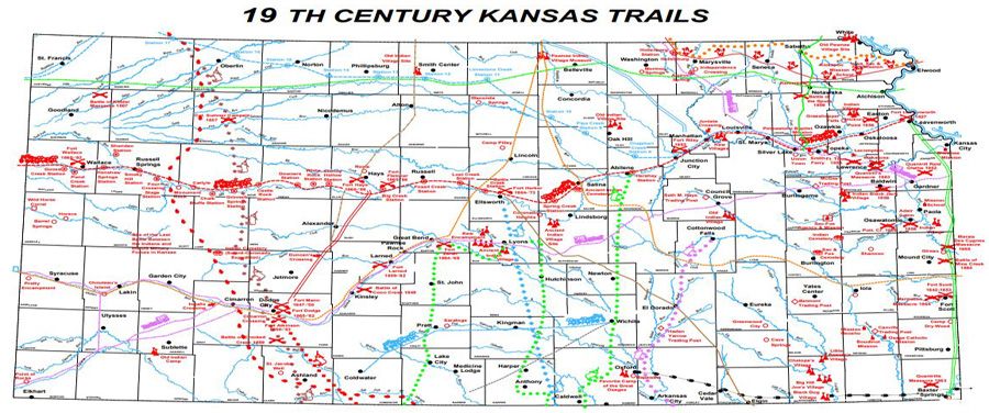 |
| Click for detailed map from KDOT |
The map includes other trails of interest including those used by indigents and that related to the cattle trade where heads were brought as herds to a rail terminus for loading. As one looks at images, the wild west was in this area (see Dodge City). "Hell on the plains" might apply to our few decades of the web.
Looking at some of the details, there was a military road (double green) that went from Ft. Leavenworth to Ft. Scott and further south. This was there early. We mentioned a Mission in the southeast corner (see Memorial Day 2022). Nathaniel Boone (son of Daniel) was in the area. Col. T.W. Higginson was in Lawrence and Topeka. Lawrence was founded as part of the abolitionists' interest in keeping Kansas free. Take a close look and note a trail (blue dashes) from Leavenworth which was originally for supplying Army posts as they expanded westward but ended up with a California connection.
In a recent post, we looked at how Ipswich MA got Ohio going. That was not long after the Revolution and was similar many ways with what happened later out west. In fact, we included a graphic (map) showing both areas. So, we could look at this type of detail across the whole of the region.
One of our interests is the long reach of New England. Both Butterfields were from New England (their relationship, if any, needs to be researched). For the most part, we will be taking time to link with both genealogical and historical information (see Lorenzo and Peggy). As well, we have a technology interest and want to include specifics of the reality of the earlier times. After all, everyone here had forebears who were alive then. The particulars of the American west are such that we can see the transitions clearly over the frontier century's span. We mentioned it before, but this map brings up the fact: going from the northeast (Kansas City) to Ft. Larned (south central, look for Great Bend) took three weeks of daily work on the Santa Fe Trail.
One more detail, Jedediah Strong Smith was last seen in the area of Point of Rocks (lower left - southwest). He was killed by an indigent part.
Remarks: Modified: 12/12/2022
12/11/2022 --
No comments:
Post a Comment