Showing posts sorted by date for query surveying. Sort by relevance Show all posts

Thursday, June 12, 2025

Lord Fairfax

TL;DR -- Little known facts are around and about upon the landscape of the U.S. Our normal attention is west (west is best; east is least - sort of thing ;>). However, there has been and will be attention to the eastern activities as the western part came about 150 years later where the Revolution became a central theme. This post touches upon the time that Braddock came over. Evidences abound due to preservation efforts. Otherwise, the landscape has been abused (data centers abound, for instance). 

--

We had to mention the 400th (Jamestown, et al) so as to set a stage that will be permanent. We would not have had the 250th without the earlier phases. So, Fairfax? His name is all over northern Virginia as are others of the upper class (kin/cuz, as well). But, the main thread will be dual. For this post, let's use "French, Indian affair" which we have touched upon before. 

While researching people who went out west from the older east side of the country, we had to bring in other cultures, such as New France and New Spain. From each, the U.S.obtained land that had to be incorporated into the Union. Too, there had to be maps that to allow reasonable control of land use (or misuse). We looked at some of this in a post titled Practice for carving about the work that went on for decades, starting in St. Louis. 

Now, in the interior, we usually think about things that happened after Lewis & Clark and the War of 1812. However, there was earlier activity out there by Europeans, for the most part related to involvement as trapper, trader, and rancher. In that regard, prior to what we are now celebrating (the 250th anniversary), there was the conflict that trained colonists for the coming Revolution. 

Namely, we consider the French, Indian affair which seems to have been mostly forgotten. Dr. Frank wrote about this conflict in his series on the Regiments that were at the Boston Siege. But, stepping back, we have had posts on this affair.  A grandpappy kept a diary that was later published: Nathaniel Knapp's diary about his time with the Louisbourgh Expedition. Some who were involved participated in the later Revolution, many times in a leadership role. 

--- 

With the French, Indian affair, we have taken a New England focus since Quebec was the principal establishment of New France. But, the conflict involved all of the colonies. An example is Virginia. 

Today while at a park, we read a historic sign. It mentioned Braddock. But, being in Virginia, there were two other names of note: George Washington; Daniel Boone. We last mentioned the former (Washington) here in this blog in a post on Col. John Glover who was featured in the series by Dr. Frank. But, Washington mapped and surveyed the Potomac River which we have to consider further. This post is a start as we have covered many of the rivers of the west

Now, the latter (Boone) has been mentioned many times in posts about the early settlement of the west. Boone, well-known explorer: opened a pass; served in the French, Indian affair and the Revolution; settled areas from the east to western Missouri; ventured out into the west.  

---

Washington was also involved with a conflict between the British and the French. The resentments that led to the Revolution are thought to have resulted with the arrival of Edward Braddock  and the reaction of the colonists to his methods. One of Braddock's early campaigns involved a planned attack on Fort Duquesne, French facility, near the start of the Ohio River. This expedition did not go well which left lasting impressions on both Washington and Boone. Braddock was mortally wounded which meant that he had no say in subsequent matters nor in the trashing of his reputation. 

---

Braddock arrival into Virginia was near Hampton Roads. After some meetings in Virginia, there was preparation for the attack on the Fort. Now, accomplishing this required going over a moutainous region that impeded traffic. Washington was familiar with the area due to his duties with the surveying crews that mapped the Potomac. 

But, let's look at the route that was set up for Braddock's forces by using a couple of images. 
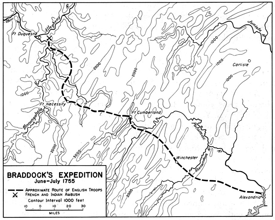
Braddock's route from 
Alexandria, VA to Braddock, PA

Braddock's route from
Cumberland, MD to Braddock, PA

The first images shows the "approximate" route from Alexandria (on the coast) which is on the Potomac to the final destination near Fort Duquesne. It passes through the interior of Northern Virginia and climbs up into the Blue Ridge mountains. This map gives us the elevations. At Cumberland, the elevation is much higher, and we see the route through western Maryland into Pennsylvania. 

---

Braddock's route went through the Keyes' Gap which is over 900-feet high. Formerly, that route from Alexandria to the mountains was called Vestal's Gap. Parts of the trail can be seen in eastern Loudoun County of Virginia. This area is near Dulles Airport outside of Washington, DC. 

The route follows an old Indian trail which is 65 miles in length from Alexandria to the  mountains. 

---

In terms of historic preservation, Loudoun County has provided historical markers with notes in the area. Too, they have a website which is of interest. This is an example of the web/cloud being useful to education at several levels. One example (2019, LoudounNow): 
  • In Our Backyard: Preserve the Vanishing Vestal’s Gap Road - property of Lord Fairfax, originally, almost 400 acres are preserved surrounded now by heavy residential and commercial development including Dulles International (and recently, the heavy foot of data centers trample the countryside). Pieces of the trail still exist (with an interest not unlike those remnants that we can see of the Santa Fe and Oregon trails in the middle of the country. 
We have written of New England (south) for several reasons, such as people from New England (north) going south. As well, the culture is the same. The south was more swashbuckling and plantation driven, not that the north was heaven on earth, let alone a beacon as desired by John Winthrop. 

Now, finally, for this post, the Native trail ran from the coast up into those things called the Blue Ridge mountains where we find things like the Shenandoah River and artifacts related to the Civil War that was mentioned on historical markers too. Right by the above-mentioned site runs a modern highway that was prototyped (real life) in the early 1800s since the traffic was heavy. It bears the name, in areas, realated to one of the early towns. 
  • Leesburg, Virginia - county seat of Loudoun County. Town of the Carters, Lees, and Masons. was in an area that was good for farms and plantations. In the War of 1812, federal documents were brought from DC for safety. 
As we proceed being involved with the eight years of the 250th and then the long trek to 1820 and Boone's western influence taking hold, there is no end to the topics to cover. One theme will always relate to the influence of New England and it families that contributing to the establishment of the U.S.  

Remarks: Modified: 06/26/2026

07/31/2025 - One of the Lord's American cousins was George Washington. We need to look more closely at the relationships between those here 400 years ago and those of the 250th being celebrated.

06/26/2026 - Updated URL for the Wikipedia image (one change - number of pixels). 

Monday, January 17, 2022

Samuel Webber

TL;DR -- Samuel Webber was a student at Harvard during the time of the Revolution. His term as President was in the period right after the split was accomplished and before the War of 1812. Those crucial times, 250 years ago, will be getting more scrutiny using new methods allowed by computing. That is, history can be made more relevant through personalization. 

--

Continuing the look at the History of Harvard (ours) through the Heads of Harvard (Wikipedia), we next consider Samuel Webber (Harvard, Wikipedia, WikiTree: Webber-762) who distinguished himself as a Mathematics Professor at Harvard prior to his short time as President. During his time, the secular spirit was rising and changing the character of Harvard. That topic has always had our interest which we will follow more closely now, given that we can identify family names to go with the discussions. One of Samuel's specialties was surveying which we have an interest in, for several reasons, such as Gardner surveying (early 1600s) and the carving of the west of the U.S. But, we want, as well, to get into changes with respect to mathematics during those times of turmoil, albeit more brainy than brawny. 

Born in Essex County, MA, Samuel moved with his family to New Hampshire. He attended Harvard as class of 1784. So his time matches up with the events of 250 years ago. There will be lots to look at. For instance, the Wikipedia bio does not agree with that of Harvard and WikiTree. Too, Webber is in our large extended family. Samuel was on of the Presidents of Harvard with little genealogical information available. 

His son married the daughter of a Loyalist. Great. So was Count Rumford whose money came in later. 

Remarks: Modified: 02/18/2022

01/17/2022 --

Sunday, December 19, 2021

Yellowstone, plus

TL;DR -- In our research, we emphasize real people, their families, and events related to their lives. And, sometimes, one finds biographies that are truthful. There have been videos with the same characteristic. However, fiction reigns. So, getting more information about one dealing with areas around Yellowstone, we went to look at what we've researched the past couple of years and have listed the posts. As usual, the main theme is the long reach of New England across the U.S. and the world. And, Harvard fits in there, too, as its history is parallel with that of the country. 

---

Frankly, as we mentioned in looking at Harvard, we want to see the influence across the great land of the U.S. and beyond. Harvard? For the pampered? Our note on John Gardner and the Merrimack surveying crew might provide a hint on our view. Perhaps not. 

We'll have to relook at that, since Harvard started up, again, in 1640 after a bit of closure post the Eaton deal. So, at least, we can say that John was learning something as he worked with the older guys. Brings up a lagging bit of work which is looking at the classes through the generations. We'll start to sample that. One key one is the big gpp, Rev. John Wise (big in several ways). 

So, expect the theme to continue that relates to the blue and red today. Those on the coast; those in the large interior; of course, with perturbations causing permutations everywhere. Now, we're about to the subject. It has to do with some fiction, on TV. So, we're not reading it; rather, it's the thing of having people extant now portray those of the past through events that might have happened. Or not. It's like the Games of Thrones; we find that very tedious and erroneous since those involved with what the theme is were real flesh and blood. Perhaps, respect of sorts might happen someday, maybe not. 

The other side of this is that people then get a warped view since they are not get a true representation. But, so what? It's fantasy. Well, in the case of this show, they use a house that is real. We'll look at the owner who is out of New England. You see, folks, New England is the core, many ways. Yes, and in the Civil War, Massachusetts was prominent, especially in Gettysburg. 

Finally, to the theme? Let's see. We're continuing this theme: Harvard, in the west. Nowadays, sure, there are students from all over. But, we're talking 200 years ago. And, Harvard was going through some changes that need some attention. As in, we can provide a mirror to lift up to the institution, perhaps. 

As we come through time, we will note the changes in Harvard. Early on, the focus was on ministers or teachers. The Adams family can be a good example, say the two Johns (politician and the mountain man). The latter had no education (Grizzly, of TV fame). The former's father (John married to Abigail) went to Harvard. His grandfather did not, however a great-uncle did. There can only be so many preachers in a family. Someone has to do real work. 

Grizzly's ancestors were of the sea which does not quite go with the terrestrial life on campus. There was no remote learning in those days. One might say that the potential influence of Harvard grew with them. The more students, the likely the remote touch. And, New England had a long reach, as we will be showing. 

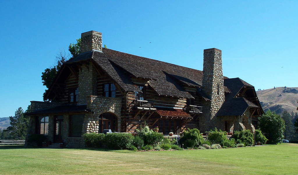
Built for
Howard Clark Hollister
and William S. Ford
However, to the theme, again. Oh yes, the show is 'Yellowstone' with an adjunct now starting with the title of '1883.' The house is the one built by Howard Clark Hollister (WikiTree: Hollister-3379). 

In the below, we provide pointers to material and to our posts (in order) on the subject so as to pull them into one place. Oh yes, from the east, it's a huge trek to Yellowstone. From the west, accomplished by sea to the coast, it's no big deal. There was regular traffic (American Indians and the French and Spaniards). 

Let's start with a map, that comes via Harvard. 

  • Map of the Yellowstone and Missouri Rivers and their tributaries -- this map, from the 1860, is great for a few reasons. It's can be panned and zoomed. Too, the 1860 timeframe is a demarcation line for us with respect to visitors and travelers. The early ones have had our focus, for a while. The later ones we are getting to as the expanse after the Civil War really accelerated. In both case, we have started to research families. 
  • Expedition of Harvard students -- this points to the journal of Henry F. Keyes who was out with others (1899) under the auspices of the Geological Department of Harvard. Have not read this yet. 
  • Jedediah Strong Smith -- have to add this since the Montana view ignores the guy who was there way early. Died in KS in 1831. The JSSS is out of the UCBerkeley area. No one back east cares?  
  • Gardner River -- we had not paid attention to The Revenant (movie) until we noticed the theme and saw that New Englanders (and southerners) were involved. We will be looking more closely at these individuals and their history. 
  • Cumberland Gap -- coming back a little in time, about the same time as Glass and his type were out there, people were coming west following Daniel Boone (real guy). Lots of those families are still around, scattered across the west. The Boones got to Missouri which is a focus for several reasons, including St. Louis' roles in the expansion of the west. Some claim that Daniel got out to Yellowstone as an old guy. 
  • Gathering of the trappers -- some came out of the east; some from the south, including the southeast; some from the coast. Again, St. Louis was a center for fur trade. 
  • Research: Rivers - having been out there several times, recently, we started to look at the mapping, especially with respect to sources. Say, the Missouri River, with tributaries that started west south of Yellowstone, coming around and heading to the Gulf of Mexico through a long trek. Nearby, the Snake collecting itself to head west. Then, the southern movement headed to the Gulf of California. The Grasshopper map is wonderful. 
  • Two different times -- looking at two times and the people involved. There were recent imports and older families early on. In fact, the Revolution's Patriots are, many times, only a generation or two from arrival, as opposed to being the Fifth Generation from New England (Massachusetts, of course). But, many were both old and new. That is one beauty of the country. 
  • Upcoming celebrations -- we do not have a 'west' focus or favor the wild places, such as Texas. We can really talk 100-year periods where, at any point, we can consider, looking back, events that were 100, 200, 250, 300, and 400 years ago. The 250? Yes, see SAR/DAR. 
This represents our ongoing research which has themes to study across a slew of time as well as across a wide expanse. No limit seen, as the U.S. keeps marching forward, its tail follows. 

Remarks: Modified: 04/07/2022

04/07/2022 --  Change Native Americans to American Indians. 

Thursday, December 2, 2021

U. S. Interior

TL; DR -- Before, we talked of the 100th, 200th, 250th, 300th, and 400th coming forward from Cape Ann. Where the 250th deals with the U. S. start. The 400th involved New England and more. Now, we can talk 400 years ago, 200 years ago, and now. 400? The forebears crossed the sea. 200? The waves of immigrants crossed the prairie and other areas of the U. S. interior. Now? We are all sailing the seas of the cyber and virtual and more due to the computationally-framed new world. 

--

In the latest issue of Gardner's Beacon, which was Vol. XI, No. 1, we mentioned one of our continuing subjects: U. S. Interior. In part, the subject of the U. S. interiors deals with history, however we add in the family aspect with the same intent as groups focused upon historical and genealogical topics (say, the NEHGS). We have called the period of over hundred years in which the interior expanded to be the Frontier Century

While browsing today, we ran across a map that looked interesting which is given below. However, let's take a moment for reflection. The map was in a collection of other images related to why the U. S. has been successful, in the world, which is a debatable subject. There was no attribution, so we used the facilities of Google's image search to find the source for the map. It showed several similar maps, however PInterest had the map and pointed to where it got the map. So, that was nice to see. 

The site is run for teachers. Here is the map which provides a timeline for acquisition as well as some indication of the geography. We have had several posts on this subject which are list below (such as, All that Louisiana brought, which is first on the list).  


The map also was used at a Quiz site. Doing this exercise made us aware of a Wikipedia page that looks at the "Territorial evolution of the United States" and provides an animated map. This reminds us of the Virginia map showing its extent over the first few decades.  

List of posts dealing with the western expansion (as we call it). Part of the discussion and work will be taken by concerns for our relationships with the American Indian
  • All that Louisiana brought (Nov 2020) -- The brown area picked up by Jefferson which included St. Louis. 
  • Sam Dunn (Nov 2021) -- A look at the interior by a Londoner in 1794. 
  • State of Missouri (Jun 2021) -- On the right edge of the brown area which was the HQ, so to speak, of those who were surveying, who were early arrivers (fur trading), or who were just passing through. 
  • Michigan, 200 years ago (Aug 2021) -- The light green area on the right includes the colonies and areas that are close. However, things, such as borders, were still being settled there in the early 1800s giving a chance to practice carving the land in a big-time way. 
  • Rendezvous (Apr 2021) -- The dark green area to the left includes the mountainous regions of the northwest (the real one, not the area around Ohio). 
  • New Spain (Feb 2021) -- Covered most of the region west of the Mississippi. This map includes the major rivers which helped carve the land. Coronado was in the middle of the brown region in the 1540s. 
  • Pre-Civil War, San Antonio TX to San Diego CA (Mar 2021) -- Cutting across the lower part of the U. S. in the early days. Again, for the hearty. 
  • Carving the land (Jul 2021) -- As mentioned, St. Louis was an early sight where the surveyors got started on the great middle. The post includes a color-coded map with discussion. 
  • Department of Interior in MO (Jun 2021) -- One of the earliest departments of the new government. Following the Boone family into MO might be of interest for several reasons. 
  • 3 Trails (Sep 2019) -- St. Louis might have been where the paperwork was shuffled, but those heading west converged on the area around Gardner Junction KS which is west of Independence MO for some time. This is in the middle brown section. 
  • Trails West (Mar 2016) -- The Gold Rush (left coast) was later. While it saw a substantial bit of travel by water (around the Cape or split with a ground jaunt across Panama), there were many who went by the trails. The Bostonian went around and sailed from Jul 1849 to Jan 1850. After a jaunt to New Zealand, it returned and shipwrecked along the OR coast. 
  • Paper Trails (Jun 2021) -- One can follow the Post Offices through time (see maps by year). Looking at the treads related to the points, one can get a sense of the eventual railroads  as well as the modern highway system. 
  • St. Louis MO to San Francisco CA (Jun 2021) -- About eight rough days for the hearty traveler. Post also shows the progress of the establishment of the railroad in three maps. 
  • Jedediah Strong Smith (Jul 2018) -- He mapped out the CA Interstate system on foot and horseback. 
  • Trapper, Trader, Rancher (May 2021) -- The Bent family out of New England eventually got to St. Louis. The father was a surveyor and agent for the government. The son was in MO, KS, CO, OK, and TX (using modern state labels throughout to save the fingers). 
  • Rivers and more (Feb 2021) -- The Mississippi and its feeders cover a lot of the brown and light green areas. In fact, water from eastern PA (and NY) go down to the middle of the country. In the dark green of the upper left, waters come down to the Missouri river. 
  • Oregon or bust (Sep 2021) -- Gardiner OR was founded where a ship of New England ownership wrecked. People went out by the wagon trains. Or, they came in from the Pacific after a long voyage. 
  • New France (Feb 2021) -- The area covered was in the upper U. S. as well as in Canada. 
  • Scholars, in general (Aug 2020) -- Papers and maps on the divides that run north to south along the western edge. 
In conclusion, New England influence by family or other parties is our interest. We can see a good reminder with respect to the founding of Lawrence, KS and the University of Kansas
    To set the stage, let's do a quote. This is from Chapter 1 in which Cordley quotes from Whittier's poem, "Song of the Kansas Emigrant:"
      We cross the prairie as of old
      The fathers crossed the sea,
      To make the West, as they the East,
      The homestead of the free.
So, as the early ones "crossed the sea" 400 years ago, we saw the later ones crossing the prairie, the river, the mountains, and the valleys 200 years ago. 

Nowadays? Flyover country or by car (1300 miles from San Antonio TX to San Diego CA, by Interstate, 22 hours). 

BTW, one other focus is technology, especially computationally framed reality. So, now we are going to be sailing the seas of the cyber and virtual? 

Remarks: Modified: 12/03/2021

12/02/2021 --


Saturday, September 18, 2021

COVID

TL:DR -- We have had an atypical year and one-half since the disease made its appearance. We were close to ground zero in the U.S. which brings up thoughts about 100 years ago and the Spanish Flu. Now, we have world-wide communication, at the blink of an eye. Yet, that power is not yet tamed. We don't know if it can be. Our work can contribute to stability, though. 

--

We just realized that we have not mentioned the plague that has been on everyone's mind for the past eighteen months. There were rumblings of a flu-like illness going around that started early in 2020. Later, we heard that the early warnings were in late 2019. In December of 2019, we were looking at our ten years of work and anticipating, as everyone else, the start of the Mayflower remembrances. The month before that, we had started a look at the children of Thomas and Margaret using some of the posts that we had done with them as the theme. Later, we did this again using a collection of descendants that had been first published on Wikipedia. There is a post per child with a list that can grow. Too, we were looking at the preparatory work being done by others (Salem's Start) and had figured out the issues related to Thomas' remains

We had looked further into Dr. Franks' books and into his and Lucie's (his sister's) relationship with Sidney Perley. We had gone through the eleven years of Dr. Frank's "The Massachusetts Magazine" and had published the Table of Contents for all of the issues. It had been in 2018 when we mused about the last issue of the TMM and mentioned the Spanish Flu's wide-spread influence on the U.S. We also were supporting research efforts at WikiTree. 

In short, we recognized all of the threads that were related to the necessary work and were doing an assessment of what had been done and to plan for future work. 

Then, there was the lockdown. COVID was here. Like with the Spanish Flu, Kansas had some of the early deaths from people in retirement communities being visited by some who had traveled with the few weeks before. Back in 1918, it had been in an Army post where troops were returning from overseas. This outbreak had been in the spring and long before the huge impact in Boston. So, thoughts of the prior century's ordeal was on everyone's mind. 

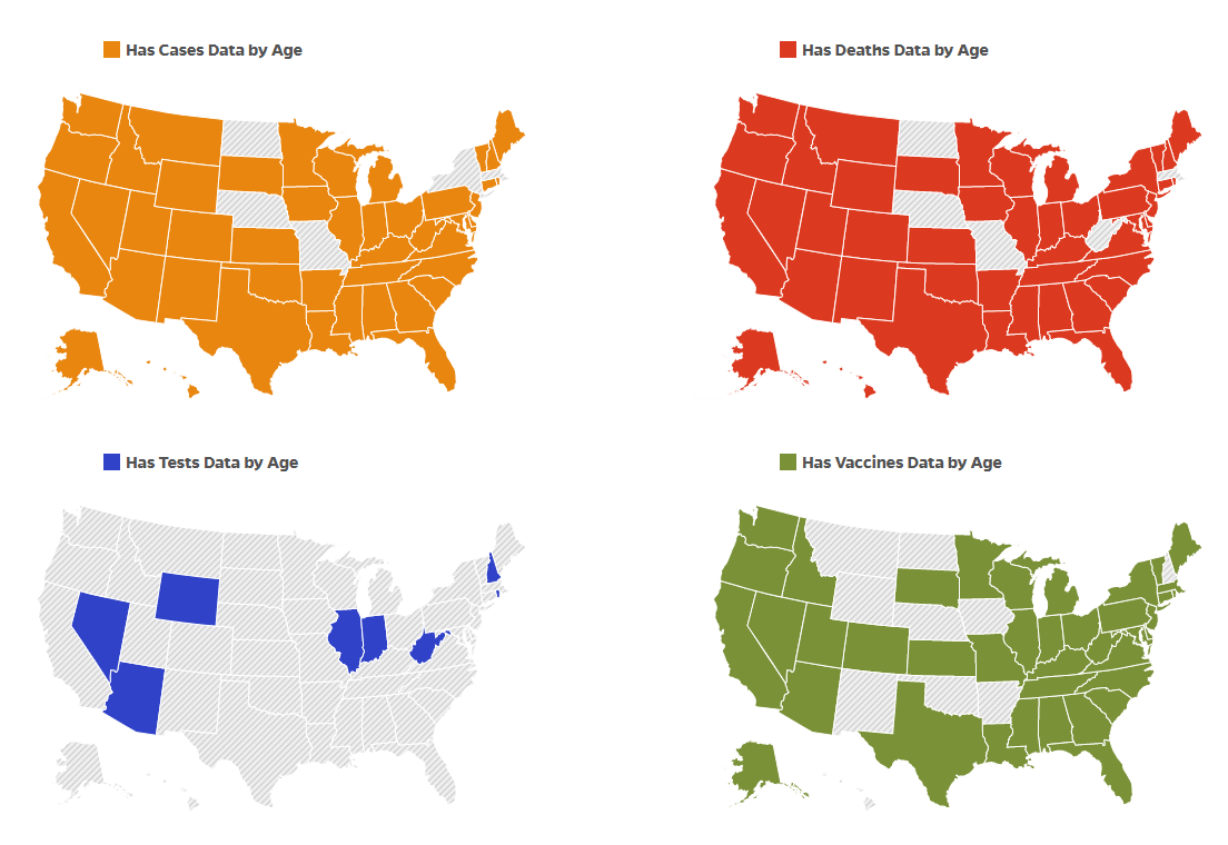
One problem was finding out good information. What was the reaction was that several news organizations allowed free access to their blogging about COVID. Also, in some venues, technical people were weighing in with facts and educated opinion. 

Tracking, Johns Hopkins

Too, a side-effect was that workers used internet access to work starting off a new paradigm that is still being managed for continuation. People could only go out for certain purposes, such as getting food. Food delivery became a norm. Lots of other patterns emerged. After that first lockdown, people were let out with restrictions. These were gradually relaxed but then tightened as new waves came about. We saw several of these. 

Finally, early this year, the vaccines became available. That release was done step-wise but was mostly available to all in the summer. We're only September. Most who wanted to be vaccinated in the U.S. have been. There were issues related to economic status and other factors that has delayed access to the vaccine in various parts of the world. 

Today, we were out in an open area. There were some masks which became the norm in the spring of 2020. And were dropped and picked back up. Right now, it's by choice of the person or the establishment where they might be. One sees large gatherings. Some are traveling. Some have traveled  due to necessity all of this time with some restrictions. That is, this is not normal travel. 

But, a corner seems to have been turned. Weymouth is up for its recognition in 2022. 2023 will see Gloucester doing its thing. Salem is not until 2026. But, there are many of these events that will take decades to go through. And, adding in New Hampshire will give us more to look at. 

Oh yes, the surrounding areas? Sure. That will be an update in the near future. Example: Two houses

In the last eighteen months, we followed up on the early western experience related to the trappers and mountain men (Jedediah Strong Smith). Also, we found out the significance of a recent movie (The Revenant) with respect to this theme, New England and family. Then, we broadened an earlier scope of migrating from the north by following southern routes through the Cumberland Gap. And, then, there was the attempts at settling at various sites (States) along the way to the west coast. 

For instance, Missouri became a State in 1821, two hundred years ago. St. Louis was a prime factor in the western expansion. The government's effort at surveying is an important topic as we watch the land being carved up. Even the area east of the Mississippi was not settled until after Louis and Clark's venture. As we look at the history, we will deal with families from New France and New Spain. Of that latter, the whole of the southwest from Texas to California will be on the scope. 

Technology? It played then as it does now. We looked at the various modes of travel. Before the railroad got its act together which involve lots of hard work as well as the maneuverings of people like Stanford (yes, of the University). But, people went west and back by various means. Samuel Clemens, himself before Mark Twain came aboard, went to California by stage across the northern route. Didn't like it. But, people made the trip on a regular basis, such as those who led folks to Santa Fe or Oregon through Gardner Junction, we might add. 

In our studies, we see that the Revolution (SAR/DAR) was the onus of the fifth generation. The fourth provided guidance through their experiences in the French and Indian conflicts. These, btw, had corresponding events back across the waters. So, we need to consider that whole area. It was the seventh and eighth generations who started to harvest the fruit of the U.S. Lots to discuss there. 

Remarks: Modified: 09/25/2021

09/25/2021 -- Added the TL;DR. Also, we can, and need to, research more on Oregon


Thursday, August 26, 2021

James Bryant Conant

TL;DR -- A New Yorker article was looking at diversity with respect to the smarties of the land. That is, who gets into Harvard. They bring up James Bryant Conant who also got into the Roxbury Latin School on testing. He was a chemist. On looking further, there wasn't any good information about his New England lineage (both sides). So, we started to make the links. Oh yes, that got us to Cape Ann, Count Rumford (whose money Harvard loved to get), JB being trained as a chemist at Harvard as part of their practical education, the SAT (and its influence by the AGCT), and more. Turns out that JB being under the radar is good for Gardner Research. We'll lift him to awareness as it allows us to have a focus on how Harvard behaved over the 400 years. 

---

Several times, we have mentioned someone who ought to be better known in a genealogical sense but who is not. One reason? No descendants to remember the guy or gal. So, if they are not famous, who will do the research? But, JB is noted (as we see below). 

We can use Joseph Gardner and Ann Downing in this regard. Ann was the owner of that which became the Bradstreet house. She married Bradstreet after Joseph was killed in a conflict with the American Indians. And so, the house got Simon's name associated with it. 

Today, we were reading about diversity versus meritocracy in college, and James Bryant Conant came up. So, Conant? That's Cape Ann. Too, he was head of Harvard for a long while. And, he introduced the SAT which type of testing was pioneered by the U.S. Army (John started this page after a bit of research post retirement) as it tried to cope with the massive inflow associated with the WWI draft. 

So, per usual, after browsing Wikipedia, we went to find out about JB's pedigree. Nothing. What? So, we have provided a link from him (Conant-639) to his grandfather (Conant-1769) on WikiTree and will fill in the missing generation. 

Here are the steps that were taken. James Scott Conant was mentioned in Wikipedia and in WikiTree. However, there was not much found on the web about JS. Well, there is a Conant Book via Google Books: A History and Genealogy of the Conant Family. Turns out that JS is mentioned. And, JB is penciled in. Only his oldest sister is mentioned. But, using the book, one can track back to  Roger. 

This image does that as well as provide the Mass VR Project record on JS as son of Thomas.  

James Bryant Conant
in the Conant Book

But, on WikiTree, an exercise would be to see how far the book agrees with what modern researchers know. But doing that, we ended up at the Profile of JB's grandfather. So, now, it's a matter of looking at the detail a little more. 

Now, there are several Gardner connections. Roger came in to replace Thomas. Too, Seeth, daughter of Thomas and Margaret, married Joshua Conant, son of Roger. The book has several other references to Gardner/Gardiner.

BTW, Harvard? We have lots of references here, so far, and will have more. For one, JB was two administrations after CW Eliot who had expected to win the Rumford Chair (see Heads of Harvard and History of Harvard). 

We have Seeth marrying a Conant. Ann has Conant in her pedigree as did Dr. Frank. So, there are lots of associations to look into, as well as further diving into things pertaining to the Dorchester Company


Remarks: Modified: 09/11/2023

08/27/2021 -- With regard to JB Conant, Frontline did a show on the subject: A Brief History of the SAT. They used a photo of JB and described his influence in getting the testing industry set up. ... With respect to not much being documented about JD's family's history in the U.S., it looks like a subject worth pursuing. He worked on mustard gas as a chemist. As mentioned, he was trained at Harvard which would have him as a beneficiary of Count Rumford's money which was given to Harvard to establish something other than counting angels on a pinhead. We'll go into that more. 

08/29/2021 -- JB can be a good example of how to handle Cape Ann descendants with respect to the 400 years that followed their arrival. We need to gather the names and start to start a close look at these families.  

08/30/2021 -- In the TL;DR, changed Boston Latin School to Roxbury Latin School where JB got entry through his test scores. 

12/11/2021 -- Added link to Heads of Harvard and History of Harvard.  

04/07/2022 -- Changed Native Americans to American Indians. 

04/12/2022 -- JB penciled in under James Scott Conant, Google book. 

05/05/2022 -- We started the series after reading of the cuz and learned a lot by looking at the perspective of 400 years. As a 17-year- old, the one posting this was in the U.S. Army in the time period right after the Korean incident where the U.S. was licking its wounds. On the other hand, Conant who was precocious hung around Harvard while young. He was well behaved, obviously. Back to Eaton (1st head - more educated than most of his peers of the time), for a moment. Let's compare then with this time of JBC's being in the vicinity. Not with judgment; rather, autodidact humanity studies coupled with computers and physical sciences might be the framework. First, look at the original complaints, with respect to the myriad ships that were afloat at the time. Then? Consider the treatment of the regular sailor (if you don't know this, we'll explain). Also, we'll get more detailed as needed. But, "much ado about not much" comes to mind. As the poster has noted earlier, John Gardner's time out with the surveying crew was cotemporaneous with early Harvard experience. That's another type of comparative study. Conant, though, served militarily. He was involved with some of the modern methods that need types of review, too. It's interesting that besides bringing in testing, Conant is associated with the movement of the institution from serving the pampered of the U.S. to looking for all of the "best and brightest" everywhere. That is, from the pseudo-Brahmin (all societies have this) to the real thing. For now, here are three links, mainly for markers. Conant is not alone in the 400 years. Lots to look at.
07/09/2022 -- Updated the prior remark, slightly. We are starting to use the generational theme more and will include Conant as an example family: 1900 forward. Ran into another Conant: The American Character

09/11/2023 -- This summer, a movie came out about Oppenheimer. The Manhattan Project had Harvard involvement with the technical team. ...  


Thursday, August 5, 2021

Michigan, 200 years ago

TL; DR -- Dr. Frank's TMM had a regular column on Massachusetts Pioneers to Michigan which we knew about but did not probe deeper. Now, we get a chance as it took longer to get areas east of the Mississippi settled than it did Missouri and Arkansas. So, we will look at both sides of the big river for a bit including a look down south with Louisiana and Texas. Per usual, we relate things to the event of 250 ago after which the developments under study occurred. And, to lessons not learned yet; the context for these change with the times; will we ever learn? 

--

In The Massachusetts Magazine (1908 to 1918), C.A. Flagg, of the Library of Congress and friend of Dr. Frank, wrote of the Massachusetts pioneers to Michigan. We did not really pay attention to this until now. The last post (Practice for carving) mentioned that there were two situations, as we might think, namely east and west of the Mississippi River. Our focus has been on the latter. Now, we have a chance to step back and look at the former. 

One motivator is the event called the Toledo War which was a verbal conflict between different parties for a strip of land that bordered Ohio and Michigan. Michigan State University provides several maps in their paper part of which are in this composite. 


Another motivator is running across a family one of whose ancestors bought land in the Michigan Strip, according to the records of  the Bureau of Land Management which records we used for studying Missouri. As the west was carved, there was paperwork to be done. Too, surveying was a big time business. One early practitioner was New Englander Silas Bent. His son was at several meetings with the American Indians with respect to peace. So, that is a topic to look into, as well.

All of this relates to the long reach of New England, across the interior and the seas. As an aside, in terms of families, the non-logical genealogists have dissed all sorts of families. We will get to that, as it is John's area. Not genealogy. Rather, modeling, problem solving, philosophy of mathematics and science and the related subjects including deep knowledge of computing (all aspects) and that wannabe called AI which has raised so much mania/angst and glee/euphoria through fairy dusting that comes from too much SciFi, fantasy, and sheer unrestrained imagination. 

That is one of the major TGS subjects for research. One might add mental health with a nod to the pair who fled the UK for the US last year. 

In any case, we will pull out the Flagg articles so that they can be used. One family was in the same spot but was, over the years, in Louisiana (lazy mode, we suppose) and then two counties in Iowa. Same goes for the Strip. And, we have not looked yet at the many other States that were populated after the colonies split from the Crown. 

For those being dissed, many died young, like the case for the Mayflower where a stepmother came along and muddied the waters. Then, the father died young, too, leaving his infant (whose mother had died early, too) with the woman who ran off, but her uncles saved the day. Then, a modern mind touting its genealogical expertise (a scientist, to boot) could not rectify the facts. This is too much of a general problem, folks. John has now 10 years experience of bouncing against this mind set. Too, those who look are talking the general problems of computing and knowledge, especially that at the higher relams where people really ought to know better. 

BTW, note that Anderson of NEHGS had everyone thinking of three wives for Thomas. Okay? Look at WikiTree. We now have it back to two (Margaret and Demaris) with some work being done to fill that picture in further. 

Oh yes, Missouri was settled in 1821, somewhat, though it took a while for the counties to shuffle to their modern definition. The Strip was still being contested (conflicted) until 1835. That would have been about the time that Texas was rumbling with respect to north and south, as in, European cultures over here with their pissing contests. We will be stepping down there, to boot. Got to love Texas, people. 

Michener, in his research, noted that the Mexican War was really a training ground for the Civil War. Dr. Frank noted that the Crown trained the U.S.ers in the conflicts with New France and its American Indian allies (so called French-Indian affairs) so that they could rebel. And, we are now approaching the 250th of that. Lucky us. We see that New England's experiences will be needed to keep things straight due to so many opinions based upon things of little to none provenance. We have to correct that over time in order to frame a better story for future generations. 

Remarks: Modified: 12/16/2022

12/16/2022 -- Finally got around to looking at the first steps west which were driven by Ipswich MA. Also, Rutland VT was involved. See Perspective, a necessity


Thursday, July 1, 2021

Carving the land

TL;DR -- So, we got the gift of the Louisiana Purchase from New Spain and New France after they grabbed the land from the American Indians. Then, St. Louis was the nexus of a carving that is so common. We started with this in New England 400 years ago. Well, all along, technology allowed the fruition. Today, old ideas are still there along with the improvements. What we want to do is thread over a spectrum some view via lives within families around and about at the different times. Spectrum? 400, 300, 250, 200, 100. And, various combinations can apply. Now, the 250th? Coming up. The Declaration of Independence which was celebrated recently if it was not forgotten due to the lure of hot dogs and brew. 

--

Lately, we have spent lots of time on land issues out west. But, the world of the sea is important, too. So, we will keep a balance; one way will be to look at things from both sides while considering the differences. So, as the seas and oceans were huge and needed to be studied, so too was the interior of the U.S. when we got the increase via Jefferson's deal. The Bureau of Land Management has the responsibility to manage the public lands which includes having records of what was there and its deposition. We can track that through time as well as pay attention to the history, the people, and their genealogies. 

Case in point is Missouri and Arkansas. This book looks at the history of the counties in northwest Arkansas which is the southern border of Missouri: History of Benton, Washington, Carroll, Madison, ... Counties of Arkansas (1889). Notice that it's published by Higginson. This is like the books that we have of the New England areas. Thousands of these accompanied the 300th lookback, albeit some were 1/2 century earlier. But, notice the topical articles, say, pioneer life or early settlers or what went into getting established and such. Given that Arkansas was of the Confederacy, there is a lot of local history. Remember, Missouri as declared as a State along with Maine, so we had a balance. And, we're talking years before Kansas. BTW, we have not gotten to Texas, yet.   

We mentioned that the Gardner guys were involved with surveying at Cape Ann and elsewhere (Merrimack). They were in good company. Both Washington and Jefferson were involved with surveying. So, too was Lincoln. This was, and still is, a regular function whose duties increased with Jefferson's deal. This image gives some indication of the size of the problem. 


The Public Land and Survey System is the current mode and represents how good systems persist. That above map is from 1988. Note, the colonies plus a few states are on another system. So too is Texas which requires special attention for several reasons. Canada uses its Dominion Land Survey

We look at this before when we were looking at rivers that headed out west and the creation of Ohio was part of the discussion. Of course, that was a New England deal, mostly. We are now a little further west and not much later in time. One difference is that we see a lost generation or two. 

Remarks: Modified: 09/03/2021

09/03/2021 --  The great northwest of the mid-east is where the practice of carving was honed out. 

Tuesday, June 29, 2021

Pace of change

TL;DR -- Before getting into some technical issues, a pause to look at the quick coverage of the interior of the U.S. is in order. In the graphic, the blue are Post Offices (1855 and 1921) as they spread across the country. The red show the railroads (1860s and 1890s). We have looked at the time before technology came about. But, even when it did, there was a natural evolution of ability. In any case, the conflicts of today are nothing new, basically old stuff with nuances related to the current time. So 400 years ago may have been different in a lot of ways, but how close are the people then to what we had 100 years ago? 

--

This post briefly summarizes work that we done over the past few months, much of it looking at the interior of the U.S. We need to get technical, for a while, which will get us back to the issues of content management and more. This has been a periodic occurrence that has left traces (see discussion at our portal - https://TGSoc.org and our technical blog) which follow how things have changed during the past decade and one-half. Lots like to ride the wave (to nowhere). Civilization needs its moments of review in order to stay within sustainable practices. The computer has messed things up. But, also, we have new ways to research and report (that was one motivation for the Web which was based upon DARPA's attempting to have robust communications). We have to keep history in mind, local and global. Too, New England and the Cape Ann crew will continue to be of use to much analysis now and into the future. 

Messy now? Yes, but, we were messy before, too. We have been covering the frontier century, for various reasons. One of these is that we have run across lots of families who were early on the frontier and seemed to have lost their lineage. Of course, there were many newcomers during that century. However, there are others who were here whose families moved into states long before they were organized and so left little in the way of tracks.

We call it the lost generation (or two) which is the ones right after the Revolution. 

So, one might argue the Boones. Daniel's prominence made sure that people paid attention. For every Daniel, there are 100s and 1000s who get little in the way of notice. Yet, these people farmed, built, surveyed, and more. On that latter, the Bent family whose member was at the Treat signing in Kansas got us on that. The father was the organizer; the son was out in the wilds. The treaty didn't hold like many others. So, we'll be looking at that (1865, Little Arkansas Treaty - that's a river out of CO that runs through several states to the Mississippi).  

Along that line, we have pulled some images that bear discussion, especially when we consider the short period of time related to the phenomenon. In this case, it is still the filling in of the interior. We are now thinking of the land being carved up. And, Missouri is a good example being the first one. It's start is in parallel with Maine's. Look at that juxtaposition. As well, the crew coming into Essex County, MA had to get things organized including surveying. Thomas and sons helped with that. John was with the Merrimack crew. In that time, late 1830s, he did learn more than those ones at Harvard. Lots to discuss there. 

Ponder this image which comes from two sources: Paper Trails (on the left); St. Louis, MO to San Francisco, CA (on the right). The left column shows the number of Post Offices at two times (1855 and 1921). The right shows the railroads, similarly (1860s and 1890s).

The times are meant to cover a 1/2 century what was from just before the Civil War of the U.S. to around the WWI timeframe. Got that? Internal conflict was the theme of that earlier turmoil. Actually, is. How are we any different? And the latter? The U.S. on the world stage in the context of trying to resolve conflict over there which was of long running, to boot. 

Getting back to the timing of those looks, on the left, notice the heavy coverage in the east coast with the sparse dots out west. On the right, notice that the railroad may have been somewhat out to the Mississippi in the 1860s but definitely not the west. A mere three decades later, the railroad did go across the county. For the Post Offices, by 1921, they were everywhere that people were. Those huge white areas are uninhabitable. Or, folks there know that they have to go pick up their mail. 

After all, in that top-left situation, mail went west by coach (several ways), the pony express, or by water (a couple of ways). That in itself is an interesting subject that we need to keep the youngsters aware of. 

On the other hand, with respect to the railroads, that 1890s coverage was quite impressive. And, it allowed faster population of the areas. 

About internal conflict, the Civil War was no cessation. Conflict with the American Indian continued for a long time leaving a situation where the reservation mode under the guidance of Washington DC was the reality for tribes. Lots to look at there. 

In short, in one-half of a century, again, the U.S. covered an area that is huge. Folks back east with their notions of wilderness have no idea about the frontier. Genealogists, are you listening? Let's step into modern modes (beyond genetics and microbiology) a little more. 

Remarks: Modified: 06/29/2021

06/29/2021 --  

Thursday, June 17, 2021

Paper Trails

TL;DR -- The Economist reviewed a book that reported on research using Post Offices as a proxy for studying population and movement. The demo and its code for the project is at GitHub with Harvard providing the data repository. This is an example of a growing trend related to reproducibility through time and across region. We look at maps that show the early start and the frontier century. We will revisit the theme as we dive further into research which will also look at nautical world as well as influences other than New England. 

--

We have followed New England's influence starting with the nautical experiences and then getting into the frontier times in the west. St. Louis will be a center point for the earlier part of the westward movement since it was involved in carving up (see Bent post on surveyor father and his trapper son) the huge pieces that were obtained via the Louisiana Purchase and later acquisitions. But, there was movement inward from the left coast, too, as well as from the south (giving us Texas, the great State) and its spheres. 

So, our research focus will include, then, four centers with Salem in the east (yes, we see Winthrop as a later arrival), St. Louis in the center, San Francisco out on the left coast, and somewhere in TX as a southern point. Perhaps, San Antonio. Too, rather than the esteemed heights of the historian (academic) as the focus, we are following families, especially in regard to the middle not being flyover country

The below is motivated by an article in The Economist (How the West was won). So, there is an aura (per usual, Brits, what else?) of judgment that seemed to waft from what the verbiage expressed. Okay, we like the mag, for depth of content and humor. Also, they are talking of a book, same title as the post. Here are some links related to the book and author. 

Now, with respect to GitHub, we have referenced this several times as it pertains to the work of Gardner Research and to the notions of the digital realm (for which we propose truth engineering as a necessity). Our portal (https://TGSOC.org) is a start on the long trek required. Expect the theme to continue. 

Before going further, we want to remind everyone of the Age of Colonialism. The U.S. did not run around the world competing with Europe. Rather, we had our own internal dynamics. The look at the carving of part of the hemisphere will cover that. The nautical? Ah, business on and enabled by the sea. Boston got its Brahmins. The left coast and Texas? We'll punt that to later posts. 

We did snap of Professor Blevin's graphic at dates that are pertinent to our work. We are diving, now, into the situation at the beginning of the wild west, and a little before as we recognize New France and New Spain. We want to go to about the 1850s where the middle was being used as a cultural battleground long before the Civil War. But, the graphic also includes the beginning (1792) and a couple of snaps from the 20th century. 

This page gives details about the analysis using Post Offices. The image below was created from snaps from that page. Note: the application is hosted at GitHub. 

This is only an introductory look. At the top is 1792 when the new country was getting its legs. There is a little dot out west marked by a red arrow (New Orleans? Too early; looks more like TX and too early; so stray dot?). The next row is our current interest which involves the early surveying times (1805) and the time of regular traffic via the trails (1855). The next row is our Frontier Century snap (1811-1921). Why 1811-1921? The snap was after a stop. The years are close enough for what we are doing now. After all, 1811 is one year before 1812's turmoil. 1921 is after both WWI and the Spanish Flu. Lots happened to families between that time. 

We will get more fine-grained later. Lots to discuss there. In the last row is 1990 which is interesting when compared to the 1921 snap. As one watches the graphic, dark regions become light as POs close for any number of reasons. The thing is that the highways become visible. 

Aside, Jedediah Strong Smith gets little respect for mapping out the CA Interstates ;>). He got us aware of the long reach of New England. But, too, he was around a whole lot of other folk that we have looked at and will continue to study. 

Remarks: Modified: 06/17/2021

06/17/2021 -- Added the TL;DR. 

Wednesday, June 9, 2021

State Of Missouri, 1821

TL;DR -- While researching we saw a pamphlet from the State of Missouri with respect to their history and to availability of records. The history included several maps at different times which show the carving up of Missouri Territory into counties. By the time that Missouri became a State in 1821 there were only a few counties. Others were defined over several decades. St. Louis hosted a World's Fair in 1904 which was the theme for a Judy Garland movie. 

--

This is a brief post with a few maps which are to show just how quickly things were changing out in the west where we can use St. Louis for a focus for a while. Before jumping ahead, here are a few pointers to related information that pertains to what the first map (below) shows.  

  • Northwest Territory -- this was being defined in the early stages of the U.S. as things were being settled. By 1805, Ohio, Kentucky and Tennessee had been established. 
  • New Madrid -- indicates that New Spain was there. Too, the Louisiana Purchase covered a lot of territory; however, notice that the surrounding pieces of New Spain and unclaimed are as large. 
  • Trapper, trader, rancher -- we have mentioned several of the trappers who were early out west. William Bent is an example of a family that had already moved. His father, Silas, was involved with the continual surveying necessary during the period shown below by maps by years. 

So, we start with an overview. There were three areas still to be handled in the northwest, name Michigan, Indiana, and Mississippi. These, btw, are east of the Mississippi that sets the eastern border of the Louisiana Territory.  


The next maps are local to the central/right region dealing with the area around St. Louis. We start with a 1804 look with names from New France and New Spain. The culture there of St. Louis is as aged as is Essex County of MA, for example. All of these maps come from a little book titled Missouri's Public Domain: United States Land Sales 1818-1922. We were thumbing through a copy of this today and are happy to find it online. In several other publications, we have seen a history of the area from several sides, such as Missouri or Arkansas or other. Some of these were quite detailed. This is quite direct and oriented toward sales. 

By 1812, what Louisiana brought was under siege by newcomers. By the next year, Arkansas was under consideration as it was being carved out of New Madrid. In 1799, Boone, himself, was in the St Charles area. He was involved in the local area. There is a tale that he went up the Missouri River, as far as Yellowstone which is remarkable for someone in their 70s.

                         1804                    1812                            1813                     
 
1816
In all of those maps (1804 thru 1813), one can see the Missouri River cutting across the top. In the middle two images, it is the top boundary of the St. Louis County which extends from the Mississippi River on the east to the left border. What is there? The next map from 1816 brings in the west and the north. A Howard County picks up the Missouri and extends the northern border above which will be Iowa. 

Then, in 1821, we see the initial look of the State of Missouri. Howard is cut down in size quite severely. Boone gets a county named for him in middle of the state along the Missouri River. 

Anticipating the movement further west, the activities of the Trails which flowed through the Kansas City area will be in Ray County. That is, as we will see, lots of traffic came down the Ohio to the Mississippi and then went north to St. Louis and west on the Missouri. It was at Kansas City where the focus changed from water to the toils of laboring across the landscape. 

All along these ways, we had families seeing something they liked and staying. Or their decision was the result of any number of issues that could have arrived. The net effect is our Frontier Century

1821

With a nod to culture, St. Louis hosted a World's Fair in 1904. It's theme was the Louisiana Purchase. We have a lot more to look at with respect to the century and what it entailed. 

In 1944, there was a movie titled Meet me in St. Louis. We can look further for New England references, but one of the stars has plenty. Namely, Judy Garland (Famous Kin). 

Remarks: Modified: 03/17/2025

06/17/2021 -- Add the TL;DR. 

03/17/2025 -- Independence and Kansas City. Stopovers for people going several ways. 

Wednesday, June 2, 2021

HMS Resolute

TL;DR -- Over 400 years, a lot happened. At first, there was the Crown as the dominant factor. At the 250th split, we had two interests, namely the U.S. and the U.K. Of interest was presence in the northern regions. A U.K. attempt failed. Rescue efforts failed leaving a U.K. ship abandoned which was found later by a U.S. whaling crew. The ship was returned to the U.K. Later, Queen Victoria had furniture made from its wood. A desk made from the wood of this ship is in the White House and still in use. Later, the U.S. Army tried to establish a northern site. That failed as did early rescue efforts. Later, another rescue was attempted jointly by the U.S. and the U.K. The lost team was found, after they had spent three years in the remote region. We have lots to look at in that regard. 

--

In our early years, we were trying to match up Thomas Gardner descendants. We still do that but have expanded to include Cape Ann families and Essex County finally getting to New England which has a long arm across the nation since the end of the Revolution. Prior to the events that led up to Lewis & Clark's jaunt, that west was New France's or New Spain's. New England had continual sibling conflicts with the former. Dr. Frank noted that this allowed the colonists to be trained under the auspices of the Crown in order to get their moxie to become independent. 

There might have been the Paris deal of 1783, however conflicts with those ones over there continued. We know of the War of 1812. There were other little frictions mostly involving Canada. When we read about characters in The Revenant arguing about who could be where, it was due to the borders being fluid. The Revenant? Why did this get attention? It's the time of Jedediah Strong Smith who was in the area. Too, those characters were either New England (north and south) or New France. The time was the 1820s. Of course, the mountain man was there until later, such as that Adams character (shown on TV) who was a cousin of John Quincy Adams. If you go west, note the names (mostly New England). 

Except, a pause. The American Indian's experience will feature in our work. 

So, we had the ruffians out west and the elite back east. Was that all? Well, St. Louis comes to fore. Jedediah Strong Smith was there for a bit. Lewis & Clark passed by. It was out of New France and old. A crew came down to there from the Lakes, namely east of Montreal. How? Around Green Bay, they started to travel up [stream along] the Fox River and later did a portage (a minor distance) to the Wisconsin River and then came to the Mississippi which took them south. Their tale says that when they got to where the Arkansas came into the big muddy, the American Indians had New Spain trinkets. So, turn about was the choice. Guess when that was? About the time that Thomas as an old man. 

St. Louis will feature in several themes due to its age and to the roles it plays with the west. At the same time that the mountain men were out west, we had the organizing elements coming into the area. One example is Silas Bent who did surveying for the Louisiana Purchase among other things. His son, William, was a trapper, trader, and rancher. He was at the 1865 Peace Treaty signing along the Little Arkansas River with American Indian leaders and many from New England. 

So, that introduction shows the interplay of time and region. It's a huge subject that can be filtered somewhat by concentrating on families rather than big themes/memes. Partly. An early example was Gen Adolphus Greeley (at the time, a Lt) and Captain (USN) George William Coffin. The former is a descendant of Sarah (Gardner) Balch; the latter is of Richard Gardner and Sarah Shattuck. The latter was of the crew that saved the former after he and his men were stranded in the Artic for three years with little to no equipment. The rescue attempt included U.S. and U.K. ships. 

Imagine that? Greeley's wife got the support for another attempt after there had been several with no success. Greeley's expedition had been to the areas of the Franklin Bay. At the time of that post (2011), we didn't take a further look, so this post is a continuation. 

Recently, we heard of a desk in the White House that came from a ship, the H.M.S. Resolute. It had been abandoned and found by a New Englander. Well, the H.M.S. Resolute was one of the ships used by the group that went to rescue Sir John Franklin. He and his crew had been lost. This has to do with trying to find a Northwest Passage. 

Later, Greeley was there to try to establish a base for the U.S. Army. We are talking the 1840/50s for the Franklin effort and the 1880s for Greeley. 

The ship [left by the Franklin rescue crew] was discovered by a whaling crew out of New London, CT. It had been abandoned. When found, its contents were in a pristine state, and the Captain (Budington) got it prepared to sail home [to CT]. At the time, there was some discussion about what to do [with the ship]. A decision was made to refit the ship and present it to England. The motivation was to show good will as the two countries were having family spats. 

Queen Victoria was pleased. Later, she had the ship decommissioned and broken down. There were three pieces of furniture made with this wood: the desk, a writing table, and a smaller desk.  The first went to the President at the time, Hayes. The Queen kept the writing table and gave the smaller desk to the widow of one of the crew that went to rescue Sir Franklin. 

That smaller desk was later acquired by the New Bedford MA Whaling Museum. 

The gift from Queen Victoria was received in 1880. Our relations improved, and the U.S. got great allies via the U.K. It was not long after this that the U.S. needed help to rescue the Greeley group. 

Remarks: Modified: 09/09/2021

06/03/2021 -- Pushed this to the FB Cover for TGS and used the Greeley|Coffin photo for the Profile. 

09/09/2021 -- Typo changed which was found during a quiet review. 


Sunday, March 29, 2020

Necessary but invisible

This post continues several threads related to the early times and now. Consider that one of our foci will be expansion out of New England. Today, we're looking at an area that also was in the sights of the southern New Englanders (VA and its surrounds). As well, we mentioned the forgotten before in another context. But, we will continue to bring to light activity that is essential yet very much under appreciated. Say, like hospital and their issues, until some catastrophe happens.

Let's look at early, first. As we noted, John Gardner (son of Thomas and Margaret) was with a crew that map the Merrimack. Winthrop had requested the work, so it was later than 1630. The Gardners were involved with very early surveying in Salem (pre-1630). One son, Abel, of John's brother, Samuel, married Sarah Porter. Their in-law was Putnam. This is one link; there are several Putnam-Gardner links that we can look at.

So, let's now see what got us to this point. While browsing music on youtube, a George Jones tune came up. It said that Curly Putnam had been the writer. On looking further (and, we have had a series looking at places and their names - where New England families are involved - to wit, the whole of the Lawrence KS area), we got pulled in. Anyway, Putnam also wrote 'The Green, Green Grass of Home' which was a hit in the '60s (Welsh singer, Tom Jones, for one). Also, Curly had been born on Putnam Mountain, in Alabama. Well, that's far south. But, we know that the enterprising New Englanders went everywhere. So, what Putnams are these?

Well, looking at this brought up several facts, however there was a slight redirection as a real gem came up. It is a history of a type of surveying by the Bureau of Land Management. This is in the Department of Interior. It may be that westerners are more familiar with this organization, however it was mentioned in Dr. Frank's Massachusetts Magazine in the context of the more northern area (Montana, et al). Can we relate that western with the southern?
First of all, it mentions Ohio. This where the work of the expansion was coordinated. Mind you, it is also on the western side of the Appalachian lines. These go to Alabama. Then, the history goes into the 'events leading to the passage of the first land ordinance' which is of the time of the Revolution. We have mentioned the 250th anniversary coming up. 

Then, the history goes through the periods which eventually get to western Georgia that was first covered by Mississippi. Alabama was split from that. Given this great effort, details had to be read and appreciated. We will get back to the changes in technology and how they influence the activity. This type of work continues albeit largely different than in those days of Jefferson. There is still the meridian issue. We see a joggle all of the time where a correction was made to a road (essentially, two 90 degree turns, in one case). 

Some topics need further attention. The first area was the Seven Ranges. After the land was mapped, the American government made choices. Early on, debt relief was a major motivation. BTW, Ohio became a state in March of 1803. It was the 17th. 

Who was one of the "organizers" of the Ohio Company? General Rufus Putnam. He is the "Father of the Northwest Territory." Remember, he is cousin of Israel, the General, as well as closely related to Ann Putnam of Witch Trial fame. 

Back to  Curly Putnam. He mentioned that his family had been in the timber business. So, we will look at that more closely. Too, though, the railroad went into that area. A few decades later, the U.S. Civil War came about. We are looking at the periods before that. 

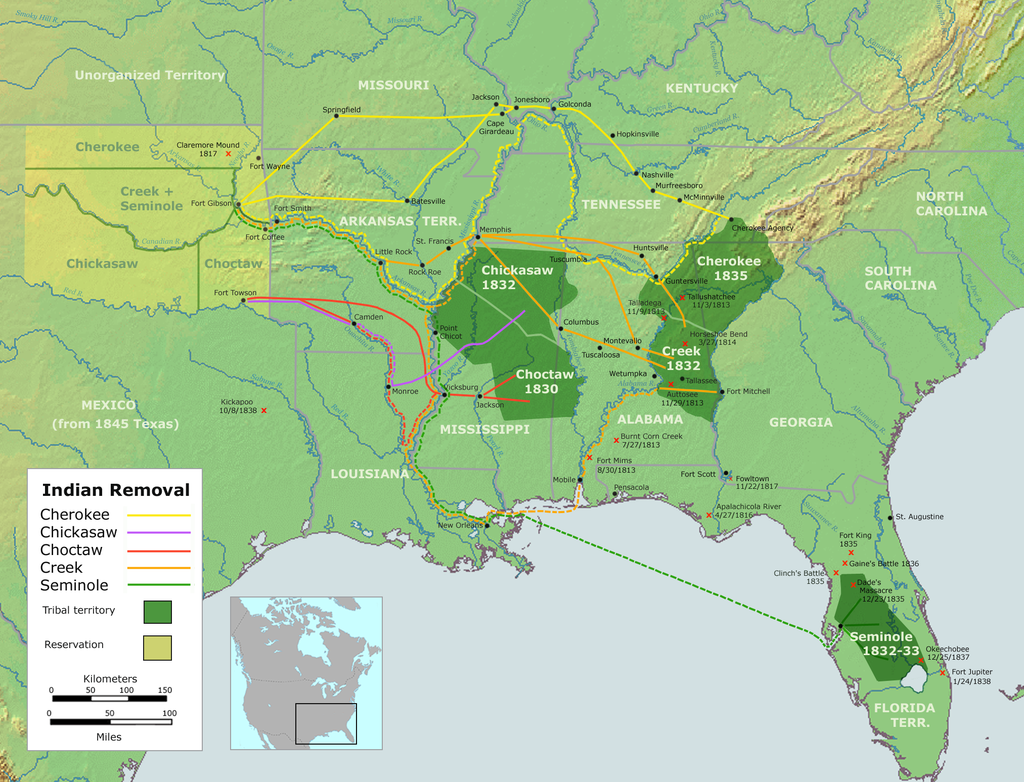
On another note, the Cherokee were in the area and forced west (Another Western Movement). We will look further in to that, as well. 

Remarks: Modified: 05/28/2022

07/01/2021 -- Now, looking at the gateway to the west

05/28/2022 -- Memorial Day, 2022 -- An Osage Mission