Showing posts sorted by relevance for query boone. Sort by date Show all posts

Saturday, January 27, 2024

Longhunter

TL;DR -- Boone was there, in the times of the French-Indian affair, the Revolution, and after. He was of a type that can be known as longhunter. They wandered and brought back information. And, turned around and led people west. This post is of the 250th theme. We are about two years away from that celebatory event. 

---

Four years ago, COVID became a reality. There had been little glimpses earlier. People were talking about an illness in China. We came home from a regional jaunt and heard, on the news, that people had been identified in the area where we had bee as being diagnosed with the disease. Okay, not long after, there was the respite put into  place. Rather, it was lockdown with rules put into place which went on for a few months. 

We had already been supporting history and genealogy work. Some of this had the flavor of finding paths taken by families as they went west. Or, from our perspective, as they came west. Earlier, we had seen entry into flyover country from several directions. The Ohio River ran from PA down to MO. But, it was Daniel Boone (see post Boone himself and search results - Boone) who figured in a large way. He was involved in the Revolution. Prior to that, though, he had explored westward our of the southern states. 

As we had noted, our focus was on the coast for a long while as we caught up with the 400 years that had passed by. Dr. Frank's work was a launching point bot from the family research and The Massachusetts Magazine which printed for eleven years and was discontinued when the Spanish Flu hit as well as WWI came about. But, we had done some work with families who went west. See Flyover Country, for one. As an aside, we are considering how to update Dr. Frank's work with respect to recent findings brought to us by technology. 

Fortunately, about the time of the pandemic, we were getting more inquires with regard to people coming west. Here are some examples (these posts are not in chronological order): Jedediah Strong Smith; Judge Thompson; Col. T. W. Higginson; and St. Louis as the site of the partitioning efforts. Too, though, we tracked several families that followed Boone west. He, BTW, ended up in MO with his son coming further into KS. 
Boone, wandering

Now, let's look at Boone and what he represented. He was a longhunter. These guys went out on their jaunts for months at a time. And, during that period, they were self-sufficient. When they returned, they brought back information and some artifacts, such a pelts. 

We are talking about the area, for the most part, that was east of the Mississippi River. There were explorers out further west, some from the Candian regions. Jedediah was out in California in the 1830, by foot both his and his steeds. He passed through St. Louis on his way. Later on, as we know, two massive killing periods happened out west: beaver; buffalo. 

The numbers of venturers was small. But, where Boone was, a Cherokee chief by 1769 was complaing about the influx of the long hunters. Mainly, they were noisy. And, other stories abound. 

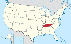
But, getting to our interests, we are finally concentrating on Tennessee. It is a huge state. All together, it touches nine states. Its northern neighbor, Kentucky, touches seven states. We follow families who went west through both of those areas. Too, their border was a dividing line during the U.S. Civil War. We have not discussed that topic in detail, yet, but intend to at some point. Since we're in KS, there is a pre-civil-war history involved with families in the area. 

Back to the longhunters, they are similar in spirit to those who sailed the seas as we saw with New England. We had an earlier post (Final migration) that quoted authors on the subject. There were many trails west, as the railroads later showed us. Jedediah, in CA, had travels that map out the current highway system. Culturally, we would point the travels of the Native Americans over their long time on the continent. 

Other types of early travelers have been touched upon during our research. About a century before the area depicted in the Flower Moon movie, a mission was established in SE KS to aid the Osage and, eventually, other tribes brought into the area. Several local sites were the local for negotiations and treaty agreements. 

Back east, the history goes back 400 years. In the interior, we are talking the long reach of New England over a 250-year period. A lot of families arrived later; but, many carry the history int heir genes over the entire period. Both require attention. So, there's no end to research. 

Lately, we have had a focus on CA, for several reasons. Some of the interest has to do with family being there early. But, we have seen lots of older photos being brought to the fore. Recently, we did a post about a photo taken in downtown LA in the 1880s. We have one from this week to add. But, the area of the photo was where Butterfield had his stage coming into the area prior to going up to San Francisco. His first arrival was in the 1850s. Change is on theme. Some things remain. Many, most do not. 

Society needs its adventurers. Of late, there are new types that we will be discussing. Despite that, we still need the old ways for many reasons. 

---

Example? Technology has developed a thrust and lust for the virtual. That theme needs constant attention for several reasons. One deals with the respect for the land and the people involved across all of the time frames that will be associated with the U.S. and its history. 

Now, AI and even AIn't? History can be retold in more interesting ways using technology. Yet, the truth of the matter remains an open issue that hopefully we'll be able to address more fully if we determine the necessity as we ought. 

Remarks: Modified: 01/27/2024

01/27/2024 -- 


Tuesday, August 25, 2020

Boone, himself

TL;DR - 1st and 2nd generation on his father's and mother's, respectively. Fortunately, the guy was peripatetic and covered territory. MO, his last frontier, is of importance to a lot of discussion that will be going on.

--

We have all heard of Daniel; TV did him in. Of late, we have had a chance to get further acquainted with him and his times. We mentioned that it was the 5th generation that bore the brunt of the revolution. The 8th started to reap the reward which has been a continuing dynamic to now; this suggests, of course, that the 400 years of American experience are going to be central to a whole lot of studies and worrying about how to decide to have sustainable lives going forward. Nothing new, really, just that we're at one 400th, with others coming up, and at 100ths and 200ths.

100th, for one, would be the Spanish Flu and things associated with that. We looked at how that influenced The Massachusetts Magazine. 200th? Well, we have mentioned Jedediah Strong Smith who went all the way coast to coast, from New England to LA and above and partly back. Was killed along the Cimarron River (lower part of the green section on the map) that flows out of the CO mountains and heads east toward the Mississippi. Never makes it as the Arkansas River intervenes.

Before that, Boone got people out of the eastern seaboard via the Cumberland Gap. Himself? He got all of the way to MO.

Note: using the USPS abbreviations to approximate areas - we know that boundaries were fluid and controversial for a while. Do we need to remind New Englanders that ME got its panache as free when MO came in as non-free?  In the below map, we are talking the yellow area.

U.S. and Missouri

A couple of years ago, we were looking at an area just west where Col. Thomas W. Higginson visited to support free-staters. But, earlier, it was the point of the trails splitting off. People came into the area from the east by river, if they could. Otherwise, it was on foot, horseback, or wagon. In any  case, we are talking 200 years ago. We are talking 1820 for the ME/MO deal (did it just go by without much notice). Well, in 1799, Boone was to the eastern side of the yellow region. He was first generation American on his father's side and second generation on his mother's. He knew how to be peripatetic.

Note: This was a mere 10 years after the "European arrival" in Australia.

During the 1820s, there were people moving west toward the green. The fact is that the east side of the yellow was the Mississippi. Boone used that as he went down to LA (not the city in CA). One could navigate, like Lewis & Clark to parts of the green. They actually made it to the light green section. Jedediah made it to the far reaches of the green and went up to the light green. A friend of Col T. W. Higginson did the trick a little later. The significance? Prior to the transcontinental railroad, it was real work.

Lots and lots to look at.

Remarks: Modified: 08/28/2020

08/27/2020 -- The significance of this area is that there was early activity by the Spanish and French. Like we mentioned in the 400ths, Coronado was around and about in the mid-1500s. But, most activity was on waterways. Boone's significance, on the other hand, deals with establishing settlements in landlocked areas. A cohort of Boone will be looked at, too, in the context of the west and how it was settled: Zebulon Pike (he after whom is named the Peak in CO). 

Thursday, June 12, 2025

Lord Fairfax

TL;DR -- Little known facts are around and about upon the landscape of the U.S. Our normal attention is west (west is best; east is least - sort of thing ;>). However, there has been and will be attention to the eastern activities as the western part came about 150 years later where the Revolution became a central theme. This post touches upon the time that Braddock came over. Evidences abound due to preservation efforts. Otherwise, the landscape has been abused (data centers abound, for instance). 

--

We had to mention the 400th (Jamestown, et al) so as to set a stage that will be permanent. We would not have had the 250th without the earlier phases. So, Fairfax? His name is all over northern Virginia as are others of the upper class (kin/cuz, as well). But, the main thread will be dual. For this post, let's use "French, Indian affair" which we have touched upon before. 

While researching people who went out west from the older east side of the country, we had to bring in other cultures, such as New France and New Spain. From each, the U.S.obtained land that had to be incorporated into the Union. Too, there had to be maps that to allow reasonable control of land use (or misuse). We looked at some of this in a post titled Practice for carving about the work that went on for decades, starting in St. Louis. 

Now, in the interior, we usually think about things that happened after Lewis & Clark and the War of 1812. However, there was earlier activity out there by Europeans, for the most part related to involvement as trapper, trader, and rancher. In that regard, prior to what we are now celebrating (the 250th anniversary), there was the conflict that trained colonists for the coming Revolution. 

Namely, we consider the French, Indian affair which seems to have been mostly forgotten. Dr. Frank wrote about this conflict in his series on the Regiments that were at the Boston Siege. But, stepping back, we have had posts on this affair.  A grandpappy kept a diary that was later published: Nathaniel Knapp's diary about his time with the Louisbourgh Expedition. Some who were involved participated in the later Revolution, many times in a leadership role. 

--- 

With the French, Indian affair, we have taken a New England focus since Quebec was the principal establishment of New France. But, the conflict involved all of the colonies. An example is Virginia. 

Today while at a park, we read a historic sign. It mentioned Braddock. But, being in Virginia, there were two other names of note: George Washington; Daniel Boone. We last mentioned the former (Washington) here in this blog in a post on Col. John Glover who was featured in the series by Dr. Frank. But, Washington mapped and surveyed the Potomac River which we have to consider further. This post is a start as we have covered many of the rivers of the west. 

Now, the latter (Boone) has been mentioned many times in posts about the early settlement of the west. Boone, well-known explorer: opened a pass; served in the French, Indian affair and the Revolution; settled areas from the east to western Missouri; ventured out into the west.  

---

Washington was also involved with a conflict between the British and the French. The resentments that led to the Revolution are thought to have resulted with the arrival of Edward Braddock  and the reaction of the colonists to his methods. One of Braddock's early campaigns involved a planned attack on Fort Duquesne, French facility, near the start of the Ohio River. This expedition did not go well which left lasting impressions on both Washington and Boone. Braddock was mortally wounded which meant that he had no say in subsequent matters nor in the trashing of his reputation. 

---

Braddock arrival into Virginia was near Hampton Roads. After some meetings in Virginia, there was preparation for the attack on the Fort. Now, accomplishing this required going over a moutainous region that impeded traffic. Washington was familiar with the area due to his duties with the surveying crews that mapped the Potomac. 

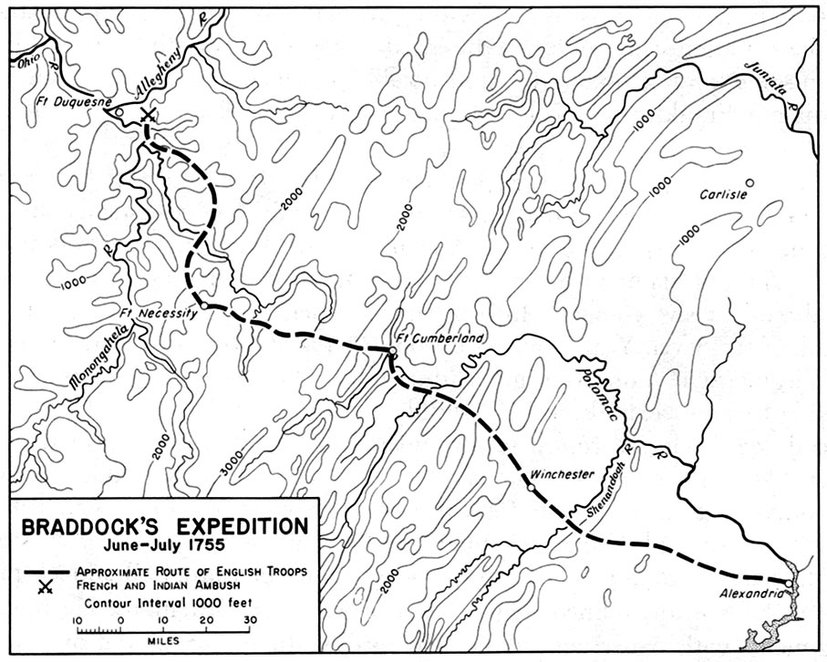
But, let's look at the route that was set up for Braddock's forces by using a couple of images. 

Braddock's route from 
Alexandria, VA to Braddock, PA

Braddock's route from
Cumberland, MD to Braddock, PA

The first images shows the "approximate" route from Alexandria (on the coast) which is on the Potomac to the final destination near Fort Duquesne. It passes through the interior of Northern Virginia and climbs up into the Blue Ridge mountains. This map gives us the elevations. At Cumberland, the elevation is much higher, and we see the route through western Maryland into Pennsylvania. 

---

Braddock's route went through the Keyes' Gap which is over 900-feet high. Formerly, that route from Alexandria to the mountains was called Vestal's Gap. Parts of the trail can be seen in eastern Loudoun County of Virginia. This area is near Dulles Airport outside of Washington, DC. 

The route follows an old Indian trail which is 65 miles in length from Alexandria to the  mountains. 

---

In terms of historic preservation, Loudoun County has provided historical markers with notes in the area. Too, they have a website which is of interest. This is an example of the web/cloud being useful to education at several levels. One example (2019, LoudounNow): 
  • In Our Backyard: Preserve the Vanishing Vestal’s Gap Road - property of Lord Fairfax, originally, almost 400 acres are preserved surrounded now by heavy residential and commercial development including Dulles International (and recently, the heavy foot of data centers trample the countryside). Pieces of the trail still exist (with an interest not unlike those remnants that we can see of the Santa Fe and Oregon trails in the middle of the country. 
We have written of New England (south) for several reasons, such as people from New England (north) going south. As well, the culture is the same. The south was more swashbuckling and plantation driven, not that the north was heaven on earth, let alone a beacon as desired by John Winthrop. 

Now, finally, for this post, the Native trail ran from the coast up into those things called the Blue Ridge mountains where we find things like the Shenandoah River and artifacts related to the Civil War that was mentioned on historical markers too. Right by the above-mentioned site runs a modern highway that was prototyped (real life) in the early 1800s since the traffic was heavy. It bears the name, in areas, realated to one of the early towns. 
  • Leesburg, Virginia - county seat of Loudoun County. Town of the Carters, Lees, and Masons. was in an area that was good for farms and plantations. In the War of 1812, federal documents were brought from DC for safety. 
As we proceed being involved with the eight years of the 250th and then the long trek to 1820 and Boone's western influence taking hold, there is no end to the topics to cover. One theme will always relate to the influence of New England and it families that contributing to the establishment of the U.S.  

Remarks: Modified: 06/26/2026

07/31/2025 - One of the Lord's American cousins was George Washington. We need to look more closely at the relationships between those here 400 years ago and those of the 250th being celebrated.

06/26/2026 - Updated URL for the Wikipedia image (one change - number of pixels). 

Monday, May 22, 2023

Three years ago

TL;DR -- Three years ago, we were coping with changes due to the pandemic that cropped up and circled the world. One lasting theme was that we got into specifics. Starting with movement to get over the barriers from the east to the west (say, Boone), we incrementally have followed families as they ratcheted west (move, settle for a while, move). The interior is full of such families. 

--

We are approaching the Memorial Day weekend which starts the summer season. It's the first of three holidays with July 4th and Labor Day being the other two. School is out for most students. Vacations are on the horizon, usually. 

But, as a reminder, three years ago, a pandemic arose worldwide, with awareness of the situation becoming to the fore in March. Pandemic? We had already written of two: Throat distemper, Spanish flu. The latter coincided with the last issue of The Massachusetts Magazine. But, this was something new: sheltering in place with little public exposure. We adapted to new ways, that were supposedly temporary. 

These posts in these three months depict some reactions of the time:
  • March 2020 - This was the first effort at adapting to the new way. Where we lived, we have wide-open spaces and were out every day. Being older, lots of events in the public sphere managed access and time (a carry-over are the carts being filled with orders to be delivered that one see while shopping). But, the themes this month were retrospective, anyway since we were in our tenth year of blogging. 
  • April 2020 - Like being house bound, we took the time to review our ten years of research. One thing that came of that was the focus, for a few months, on the interior of the U.S. as it was carved under the control of St. Louis. We sampled various times and places related to the movement out west.  
  • May 2020 - Tales from the westward movement started to crop up. Just getting out of the east was problematic. The below quote? Trying to conquer the western portion of an Atlantic State. 
    • "One lady was quoted that she would hide her infant by a bush and follow the wagon up hill (with one task of chocking the wheels of the wagon if the horses tired). Once the hill (very large one) had been conquered, she went back down and came up with her child." A huge name involved with the escape was Boone of the south, who got people over the mountains into the area that launched the western movement. Boone himself, as an old guy, was all the way to what is now known as Kansas City. But, that was not even half-way to the west coast. 
There was a change in focus that has continued. We did not have an explicit post on Covid until later (June 2020 - Modes and protocols; The future). We did several retrospectives over that time. Then, we wrote of a 100+ year old lady who application to the Mayflower Society (Deeper dive) never took, for several reasons (we have written of that here). She is now gone (and knows, Mayflower people). 

Actually, about that, one wonders how well the computer will be in doing some of this work (that is, genealogy). We already have many examples, so the topic will be on the table. 

Remarks: Modified: 05/22/2023

05/22/2023 -- 


Thursday, August 27, 2020

US Territory

TL;DR - Military man. Went up the Mississippi to its start. Then, went out to see the Rockies. Found the source for the  Arkansas River. Had a run in with the Spaniards. So, was taken to Mexico. Sent back. The War of 1812 came up, and Zebulon Pike died. Young man. He, of several, helped us map out the western U.S. where the states can be huge.

--

Having been looking at families as they moved west, we have learned a lot with respect to history, genealogy, and life, in general. For one thing, there are people who need to be recognized for their lineage, albeit some of the genealogical bent have this bias (it's the paper that counts, silly). On the other hand, people had lives and left others behind. One consequence of the forever shift is that things get lost, like who was where.

As an aside, we know of Zebulon Pike's life. He wrote of it. After looking at Daniel Boone, we figured that we need to move further west, as Daniel stopped not far west of the Mississippi. Hence this post, as those who went west did it with labor. We'll get there in a continuation of the western movement series that started a few years ago. So, let's stop to look at the US States and some of their attributes.

After a brief pause, though. One thing that stood out in looking at early Massachusetts and New Hampshire is that someone could move, even two counties over, and be forgotten in the sense of not being included in some write up. So, it was understandable when someone went further west. Say, the Mayflower descendant out in the lonely prairie grave - see Bayes post - more coming. In his case, a book on his family starting with the 17th century arrivals just noted that he was out west. In another case, some abolitionist was hanged in Texas (pre-Civil War) for being there. We found this out by digging. Lots and lots of stories to tell; fortunately, the internet will allow a more full fleshing of history through time. So, people will be a common focus; we will set up a proof process for descendants of Thomas and Margaret; however, friends will be allowed, to boot.

So, there was a comment about Boone being known for migration on land. After all, his party went by foot from NC to TN and west out to MO. The old guy (in his 80s) is said to have taken a party out to the Yellowstone area. Pike, on the other hand, was young. He mapped the source of the Mississippi. He did the same for the Arkansas River, poorly equipped in late fall (snow of the Rockies). Then, he was taken down by the Spanish to Mexico and brought back. His travels were after Lewis & Clark and before the Santa Fe trail.

Note: we got on this theme with Jedediah Strong Smith and Judge Thompson of Massachusetts, in part.

Looking at the U.S., all of the larger states are out west. For instance, KS is 81K sq mi. This is mentioned since Col. Higginson went there explicitly to show support for John Brown. Too, it was traversed, in part, by the trails, with almost 6/8ths of the trail in KS (Santa Fe Trail). But, Pike went through the area, too, earlier (The White Man's Foot in Kansas). Lots have been written about Pike.

The largest state is Alaska with over 1/2 million sq mi. Texas is next (it'll be featured due to several connections with the East Coast, including New England). This comparison is not for bragging rights; rather, the amount of effort to go across an area relates to the distance. However, terrain was a larger factor. Drive across WV, sometime, and note the absence of any flat area. Or, what they call flat is not really.
Size of States, U.S.
The tales of the Sante Fe Trail mention that parties, sometimes, took the harder route in order to avoid conflict with the American Indian population. From a commercial view, that makes sense. We will look at that. Usually, the path of lesser resistance was taken. Say, moving from Gardner KS to above St. Joe MO in order to save a few days (the gold in CA was calling); besides, going up the MO river was easier than sloughing out west by land. Even if for a few days. Choices.

Remarks: Modified: 02/27/2021

02/27/2021 -- Changed to using American Indian. 

Tuesday, April 20, 2021

Frontier century

TD;LR -- A photo of Alexander Gardner of Lawrence, KS gets us to back up from the end of the frontier century to its beginning. Kansas came out of the Louisiana Purchase which became known as the Missouri Territory. An early split out was Arkansas. So, we need to look at that are in terms of events at the same time that we pay attention to the far west. 

--

Just saw a photo of Lawrence KS from 1867 at a FB site related to the city's history. It came from the Kansas Historical Society. The time of the photo would have been over 10 years past the visit by Col. Higginson and shortly after the Civil War. This photo was taken by Alexander Gardner who came over here from Scotland. 

Massachusetts Avenue
Lawrence, KS

The area had been part of the Missouri Territory which was a renaming of the Louisiana Territory after that State was formed. We will be looking further at the Missouri Territory due to the western movement going through that area. At the time of the mountain men (such as Jedediah Strong Smith whom we will look at further; also see Rendezvous) which was early 1800s, there were people settling in all of this area. Boone was one. 

Here is an early map of this territory. 

Notice that Texas in not included. However, we are dealing with families from all over this area, some of whom were there about the time of Boone. 

Also, with due respect to the brains of genealogy, they have missed several boats. We will explicitly deal with several of these as we go along. 

Here is another view, a little later. Arkansas Territory ran along the TX border and included OK. We will look at families who came out of the east (Cumberland Gap) that covered that area: MO, AR, OK, and TX. Some of these folks had ancestors who went south from New England. Others met Yankees out in the western expanse, thereby closing the tie of the New Englands, north and south. 

Arkansas cut out

BTW, a motivation? One deals with frontier issues being different than that 'wilderness' view of the east coasters. We might use the label of America's Lost Generation. 

Remarks: Modified: 07/25/2021

04/21/2021 -- We will be looking into the 400th as an event of importance. At the same time, we will consider a thematic cover, going backward 100, 200, 250, 300 and 400 years. The 250th? Upcoming relook at the Revolution. In terms of the 100th, which is the end of the frontier century, we can use individuals, such as Amelia Earhart, William Coffin Coleman, and others.

07/25/2021 -- Missouri is where the carving of the great U.S. landscape started. Driven, we might add, by New England. We'll think of some piece to honor George Kimball III who died this month in 2011, cuz of Ann several ways.   


Tuesday, August 11, 2020

Reasons ... for New England

TL;DR - Why did people come here? That is, to this side of the pond. Lots of reasons. Boone is an example of a later arrival who made good.

--

Recently, we revisited the topic of Origins and Motivations. In that post, we listed earlier posts dealing with the subject. As we proceed, we will be pulling posts from the past, into some type of cohesive view as this allows us to reflect on what we have seen as well as think about the future. And, we need to consider post-virus realities, for various reasons such as our sanity.

Speaking of reasons, we had a query about the motivations for New England. Our response went along this line which follows what we have run into the past decade.
    Rose-Troup (she researched the Dorchester Company in England for years), Albion's Seed (nice look at the paths that led to the U.S. from England), and on Dorset (great countryside).
However, let's broaden the scope. As a first step, we can look at the view of the Revs. White, Winthrop, and Higginson. At The Winthrop Society's site, we find this document: "Reasons for the Plantation in New England". It has a list of Reasons and then some Objections. We will go back through these, but let's look at one Objection.


In the introduction, we are told that the author is not known but that later edits were done by John Winthrop. The changes are in the hand of his son.
    Redacted and introduced by Marcia Elaine Stewart.

    The following document was found among the papers of Governor John Winthrop. Other abridged versions are known, and variously ascribed to Rev. John White, John Winthrop or Rev. Francis Higginson. While the true originator may never be known, suffice it to say that this copy was written in the hand of Forth Winthrop, son and sometime secretary of the future Governor, and has marginal notes by the elder Winthrop, dated 1629. It was evidently a widely distributed and influential piece of propaganda in furtherance of the proposed settlement of Massachusetts Bay, judging from the number of copies in various forms which are still extant, along with numerous responses pro and con penned by various interested worthies of the day. The Rev. John White probably conceived the initial nine arguments, but we suspect, due to the legal style of its arguments, that Winthrop has here substantially amplified it to its present form with the addition of the objections and answers. In any event, it is surely an expression of Winthrop's own views on the subject, and is of great significance in revealing the motivation of the colonists.
Now, we picked this objection since we have looked at the topic, example: The First Year. We quote Anne Bradstreet's reaction to the new environment. Now, why mention this? As people went west, or to any of the newer areas, it was the same thing (like Yogi said, deja vu, all over again).

Too, though, this type of material allows to discern some of the thinking of the time, especially since there is more of a meditative tone than the modern mind might like. Yet, are we missing something?

Remarks: Modified: 08/28/2020

08/28/2020 -- Daniel Boone will be a focus, for a while. Quaker family that came into PA pre-Revolutionary times. 

Wednesday, June 9, 2021

State Of Missouri, 1821

TL;DR -- While researching we saw a pamphlet from the State of Missouri with respect to their history and to availability of records. The history included several maps at different times which show the carving up of Missouri Territory into counties. By the time that Missouri became a State in 1821 there were only a few counties. Others were defined over several decades. St. Louis hosted a World's Fair in 1904 which was the theme for a Judy Garland movie. 

--

This is a brief post with a few maps which are to show just how quickly things were changing out in the west where we can use St. Louis for a focus for a while. Before jumping ahead, here are a few pointers to related information that pertains to what the first map (below) shows.  

  • Northwest Territory -- this was being defined in the early stages of the U.S. as things were being settled. By 1805, Ohio, Kentucky and Tennessee had been established. 
  • New Madrid -- indicates that New Spain was there. Too, the Louisiana Purchase covered a lot of territory; however, notice that the surrounding pieces of New Spain and unclaimed are as large. 
  • Trapper, trader, rancher -- we have mentioned several of the trappers who were early out west. William Bent is an example of a family that had already moved. His father, Silas, was involved with the continual surveying necessary during the period shown below by maps by years. 

So, we start with an overview. There were three areas still to be handled in the northwest, name Michigan, Indiana, and Mississippi. These, btw, are east of the Mississippi that sets the eastern border of the Louisiana Territory.  


The next maps are local to the central/right region dealing with the area around St. Louis. We start with a 1804 look with names from New France and New Spain. The culture there of St. Louis is as aged as is Essex County of MA, for example. All of these maps come from a little book titled Missouri's Public Domain: United States Land Sales 1818-1922. We were thumbing through a copy of this today and are happy to find it online. In several other publications, we have seen a history of the area from several sides, such as Missouri or Arkansas or other. Some of these were quite detailed. This is quite direct and oriented toward sales. 

By 1812, what Louisiana brought was under siege by newcomers. By the next year, Arkansas was under consideration as it was being carved out of New Madrid. In 1799, Boone, himself, was in the St Charles area. He was involved in the local area. There is a tale that he went up the Missouri River, as far as Yellowstone which is remarkable for someone in their 70s.

                         1804                    1812                            1813                     
 
1816
In all of those maps (1804 thru 1813), one can see the Missouri River cutting across the top. In the middle two images, it is the top boundary of the St. Louis County which extends from the Mississippi River on the east to the left border. What is there? The next map from 1816 brings in the west and the north. A Howard County picks up the Missouri and extends the northern border above which will be Iowa. 

Then, in 1821, we see the initial look of the State of Missouri. Howard is cut down in size quite severely. Boone gets a county named for him in middle of the state along the Missouri River. 

Anticipating the movement further west, the activities of the Trails which flowed through the Kansas City area will be in Ray County. That is, as we will see, lots of traffic came down the Ohio to the Mississippi and then went north to St. Louis and west on the Missouri. It was at Kansas City where the focus changed from water to the toils of laboring across the landscape. 

All along these ways, we had families seeing something they liked and staying. Or their decision was the result of any number of issues that could have arrived. The net effect is our Frontier Century. 

1821

With a nod to culture, St. Louis hosted a World's Fair in 1904. It's theme was the Louisiana Purchase. We have a lot more to look at with respect to the century and what it entailed. 

In 1944, there was a movie titled Meet me in St. Louis. We can look further for New England references, but one of the stars has plenty. Namely, Judy Garland (Famous Kin). 

Remarks: Modified: 03/17/2025

06/17/2021 -- Add the TL;DR. 

03/17/2025 -- Independence and Kansas City. Stopovers for people going several ways. 

Monday, March 17, 2025

Independence and Kansas City

TL;DR -- Trails were and still are in the sense of leaving tracks on the landscape (several places along the Santa Fe and Oregon Trails. And, now the Interstate Highway system with all of the national, state, and local roads. And, going further, even now dirt roads as tracks. Sometimes converted railroad tracks. 

--

With all that is going on in the world, and in the U.S., it is time to look back at the past. In 2020, we got the opportunity to spend time looking at the interior of the country which is huge. In terms of time, we had a frontier century (post has copy of photo of Lawrence, KS by Gardner). We got to learn about the trails and the cities that cropped up (theme of this post). We determined that there was a lost generation or two (Boone was real; officer in the US Revolution; Longhunter; traipser of land (all the way past KC with time spent in western MO) in the movement that came to fore as we looked at the upcoming 250th of the US under the auspices of the Daughters of the American Revolution. Doing applications for some requires lots of additional work. 

Before 2020, we had looked at the trails and those earlier like Jedediah Strong Smith. Gardner, KS was seen as a hub of traffic and activity. Also, we had looked at both land and sea traffic to the left coast (Old LA and the US - as in Los Angeles, CA - in particular, Bunker Hill West, where the culture went back to New Spain and then through several cultural shifts to the current canyons of high rises).

---

Now, to the theme. We saw a video of a talk about the trails and how they came into Kansas City and left. It was of the first part of which there will be another. We mentioned Gardner, KS where 3 Trails split. The Oregon went over the Wakarusa River into the Lawrence area and then up to Nebraska. Even in that trek, the rigors of getting people and goods across the land was obvious, especially trying to get over waterways which were boons and banes (mostly the latter for many). 

The talk: How Independence & Kansas City Became Trailheads for the Oregon/California/Santa Fe Trails, Part 1. The following image came from the talk. On the map (a modern map showing some roads), Independence, MO (where Pres. Truman came from) is on the upper right. Gardner, KS is on the lower left. 

Indepencence, MO
Gardner, KS

In the top middle, notice Wesport which is on the Missouri River. After a little bit of time, impatient travelers (read, young men off to the coast with gold fever) realized that they could take the river up past St. Joseph, MO (famous for the Pony Express) and then a little further north, they could head west in Nebraska. While doing that, they would meet travelers coming up from Gardner, KS. But, they would have cut several days off the journey. 

OCTA, sponsors of the research and talk

---

Notice that this is about the early times. The railroad came into play after the Civil War. 

Generations? By this time, say before the Civil War, we were to the 8th generation from the start of New England. The Revolution was mostly of the 5th generation. 

Cultures? As we have noted, there were the News: Spain; France; England; Sweden; ... The left coast allows us to look at the first; Quebec, Canada is representative of the second; we had both a North and and a South for the third; and so forth. 

---

KC? MO and KS. Missouri and Kansas. We need to look at the area a little further. It's known for beef and barbeque. Well, cattle came up from TX to be shipped east to the hungry easterners. Too, the breadbasket founded itself on the rich lands of the area. Boone, as said, was there early. It's sister city in MO, St. Louis, was the administrative and bureaucratic and entertainment hub. See early Missouri, for instance. 

Remarks: Modified: 03/17/2025

03/17/2025 -- 


Monday, August 10, 2020

Scholars, in general

TL;DR - Earlier, we saw a Middle School reference some our work, indirectly. Looking at later material, it is nice to see U.S. history lessons. In particular, geography can help us understand what people went through, especially in all of the goings and comings on land (post Lewis & Clark and Boone). Water. Necessary. Can be a problem, at times.

--

Back in 2011, we read that a Middle School in Peabody had Thomas Gardner on a list of colonials for the students to study. Part of the material came from our publications. Later, the post disappeared.

Of late, we have been looking at the western expansion using Cumberland Gap as a reference point to discuss the realities then of moving from one place to another. Motivation for that came from looking a families in the south, many of whom had come down from New England. Post the U.S. Revolution, there was an upswing of interest in the west. Consequently, there is a lot of material to cover.

But, one factor was the waterway. We noted from the group that went from Massachusetts to Lawrence KS traveled part way on foot through terrain that might have been less severe than people would find out west but was still difficult. As mentioned, going from the Kansas City area to Fort Larned on the Sante Fe Trail (a mere few hours now by car) was almost three weeks of daily grind. We looked at some of the issues in a recent post: Cumberland Pass (which is near a mountain named for Harvard).

The travelers had to go over divides, albeit in a lesser mode than one would require if there was not a choice. Say, a pass that is 12k feet in height is quite different than what was required for traversing the Cumberland Gap which was still work. As we mentioned in an earlier post, this summer, a woman talked of leaving her infant behind a bush as she helped her husband get the wagon up a steep climb. They were using horses which had to stop to get a breath. Well, the wagon needed to be chucked to relieve the strain on the horses. After they got to the top, the woman would go back down, get her infant, and come back up.

And, then, it was down the hill until the next rise. That's why we mentioned the ford near Lawrence KS as training. Same routine, albeit, less slope and distance. Lots of stories like that will come to the fore with events like the 400th plus the existence of technology for presentation of information on-line.

One huge divide results in the Mississippi River and its tributaries. Those were major obstacles. This get us back to education. There is a graphic of the Continental Divide on material used for 4th-Grade science which was interesting (first bullet). As well, the site provide coding opportunities. Yes, adults need to get their heads in that mode, too. So, looking further at the posts that can be found on this divide, there is a report on traveling the Trail Ridge Road in the mountains near Estes Park. It has wonder photographs (second bullet). So, taking that further, and coming up on the scholar's view, there are other types of faults. An Earth Science post shows us the triple divide (third bullet). That leads to the more general view which would include the Laurentian Divide. The photo on the right is from this Wikipedia article (fourth bullet).
So, we have a new series to talk about: on-premise, cloud, mobile. That is, these refer to the types of platforms and presentation options related to the modern distributed mode. As in, the TGS, Inc. will be at the forefront of illustrative material being offered which can cover all of the intellectual levels.

In the prior posts, we showed the Mississippi watershed. However, look at the yellow line. That's the initial barrier that gave Daniel Boone fame. And, going north, we had divides up there, albeit we lost Canada in the U.S. Revolution (never had it, even Maine wanted to split off).

Remarks: Modified: 08/28/2020

08/10/2020 --

Wednesday, July 15, 2020

Cumberland Gap

TL;DR - Looking at the eastern part of the west, where getting to the other side of the Mississippi was an issue. But, Boone got us out of the trap that held up traffic. Too, the CP church grew along side the expansion of the frontier helping us now with their records.

--

While researching further with regard to movement west, after the Revolution, we have been using several families. We became acquainted with a split in the Presbyterian Church that resulted in the Cumberland Presbyterian Church. That is a topic bearing more attention. But, following a 'circuit rider' around got us to the Fort Worth area of Texas before the War with Mexico.

And, that? New England's long arm stretching across and influencing the country. This is a real dynamic, folks, and bears some study. Again, we might add. With technology, we can look at this stuff in unprecedented ways. So, we'll get back to that. For now, let me remind everyone that we are tracing movement both west, southwest, and south out of New England. Our GSMD work was an example of that which we're deep diving into, stepwise.

Let's pause to reflect. This image is a prelude and a precursor (oh yes, let's look at the whole of the trek back 200 years ago). This image is showing movement west out of North Carolina (it's a long way to Oregon). There are modern-day highways that we can talk about just like we proposed that Jedediah Strong Smith laid out the California Interstates.


Yes, BTW, Davie Crockett was a member of the Cumberland Presbyterian which is still separate however it is merging with a split that was done earlier, the Cumberland Presbyterian Church of America. One thing to note: CP is a collection of small churches in many places; as opposed to the other view of things that goes huge (cathedral like).

Anyway, we were poking around looking for some information on North Carolina as the principal players of the CP came out of NC. And, found this blog: Carolina Frontier Settlements. Per usual, we looked for Gardner, either in the context of All Things Gardner or looking for collateral families.

We found Fay Webb Gardner's little scrapbook. It starts with some hand-drawn charts. And uses some type of form reminding me of the book that Dr. Frank utilized to do both of his lines by hand. Also, in looking at these pages which include some prose, we noticed O. Max Gardner. Okay. He was Fay's husband and quite successful. Too, he and she were involved with the Gardner-Webb university that we looked at earlier.

But, stepping back to the west. We are dealing with the early stages of wagons west where people got to places before the government followed. And, they were remote. So, we can go on about differences in types (stay at homes - like in the lockdown or the go abouts - most balance this). But, in the old days, when you were on the frontier, you didn't have Bozos there delivery crap. No, we need really need to write about this. It's not unlike Thomas' and Margaret's experiences on Cape Ann and beyond. But, they were effective; to wit? The kids.

Remarks: Modified: 03/05/2021

07/15/2020 -- I read today that one of the CP Ministers who pioneered in Texas, establishing a church in the Fort Worth area, was hanged due to preaching abolitionist's views in 1859. He was a young man. This is one of those things where one sees all sorts of different views on the web. Hence, our portal to truth has become a focus.

07/21/2020 -- Book on the subject of Texas lynchings: Eternity at the end of a rope ...

08/06/2020 -- Changed the title to Cumberland Gap which is a pass through lower-central Appalachian Mountains. One could think of this pass as a training group for those who were going to proceed further west. One had to get teams (oxen, horses) up and down non-normal elevations with wagons of various sorts that were heavily loaded. Even in the crossing of the next piece of the U.S., there was struggle. The journey by wagon from Independence MO to Fort Larned KS on the Santa Fe Trail took about three weeks of daily grind. Once past the plains, then there were more mountains, such as the Rockies where we find Cumberland Pass (10K feet higher). Of course, one is still, then, only a little past 1/2 way if one was going to Oregon or California. One fact is that those moving west were always ahead of the record keepers so that one finds holes in the story of a family. Sometimes, these can be filled in; other times, we get what's known as a brick wall.

08/28/2020 -- Two names that will be coming up, Daniel Boone and Zebulon Pike.

03/05/2021 -- On rivers (waterways and barriers). 

Thursday, December 1, 2022

Perspective, a necessity

TL;DR -- Ipswich has been a topic from time to time. It had shipwrights. Of course, different size of vessels were handled. There were no biggies like Boston (MA) or Bath (ME) or Norfolk (VA). Other examples of industry and technology can be used. But, Ipswich led the way to the expansion across the interior that we saw for over a century. We will be looking at that, as after all, New England has a long reach. Ipswich has done well for itself. 

---

As technology runs toward the future, we always get to states where we get locked in. We cannot go back. Technology is great, except for when it doesn't work. If the problem is solvable, then we have a glitch and a correction. If the problem is systemic or not resolvable within a reasonable timeframe and costs, we have adjustments rise as imperatives. Learning drives technology; unlearning drives recovery from technology's failures. 

The U.S. is about the best example that we have for several reasons. We have already addressed technology as being our main focus. We have 400 years of data to ponder, in this regard. But, just those pieces of evidence from the past 250 years is worthy of study, too. And, commemorative moments, such as we are having now which will last decades are a time to reflect and learn from the past. We are surely in a different mode than the generation of the recognition of the 300ths. 

Today, we are featuring Ipswich which does not come to bear until later, but it does involve Essex County. Reminder, Cape Ann (Gloucester) has their moments in 2023.  It was from Ipswich that a group went west. Gen. Rufus Putnam (Wikipedia, WikiTree) was one of the leaders of the effort. Let's look at some particulars. 

Historic Ipswich is a website that has been quite a motherlode of information. Of course, we are interested due to the many families in the heritage who had Ipswich connections. For one, Rev John Wise has an interesting bunch of  events in his life that we can learn from. We have been looking at shipbuilding in little Ipswich as well as similar work in the County (see Newbury Essex County MA).

The website has looked at Putnam's effort: Ipswich to Marietta, December 1787. First, they show the result of contention between the States with regard to this unsettled land to the west. We mentioned that in the last post about Family Search and their great support for research. Then, the post has the photo of a plaque that notes the endeavor. What? That got our attention, as we have been looking at the western expansion and its frontier century, including lost generations that plague genealogists who have no imagination. Why say that? These people were. Some were newcomers, true. Many were representative of the long reach of New England. Along with technology (and its specifics), our interest deals with identifying the examples of that reach plus the evidence now of its continuing existence. 

Then, the post looks at an effort in 1937 to redo the trek while documenting the effort. For one thing, they provide the map that gives details of the geography. That was great to see as we have looked at the west and its rivers and its great expanse and the carving that was inevitable. Lots of this was with a focus on St. Louis, the gateway. Putnam kept a journal. There were other reports written. In short, it was a great find that was more special since it involves little Ipswich (influence a huge multiple of its size). 

Now, let's look at perspective. Technology makes people lazy; oh, managers will say that it increases productivity. In terms of the former, heard of AI? It's a huge scam which we will show as we go along. Yes, balancing mathematics with knowledge with respect to culture that the broad history of U.S. allows. After all, we are a nation of immigrants. Luckily, we have two broad scopes, related to the colonial times versus later. Too, we have cultural associations with the old countries, for the most part. The list goes on and on. So, expect this theme to be recurrent. BTW, that which is being touted as AI is merely fancy math being exploited by computational prowess that came via modeling founded on (guess what?) mathematical modeling and the detailed work over the centuries. Yes, we will to touch upon all of that. 

For the time being, we will present the following map with some commentary afterwards. 


This graphic shows a map from the prior post which has one view of the partitioning before the carving that was involved in establishing the States. 

1) deals with the Michigan Territory (again, the prior post) that we just offhandedly dismissed as practice for the carving. Our only excuse was that we were dealing with the broad expanses beyond the Mississippi River, but that was not correctly assumed. We have to step back given that the focus of DAR/SAR is the upcoming 250th of the U.S. Besides, we have to give generations credit. This deals with the fifth and the sixth where the latter is the first of those that were heavily in the lost side of things. 

After all, people moved and did so quickly, once the way was set. Say, thanks to the likes of Daniel Boone and Jedediah Strong Smith. The former was doing his exploration prior to the Revolution. The latter was directly connected with St. Louis and its influence. We will go into that deeply. 

A point to make is this: that trek from Ipswich was difficult. Hence, there were real reasons why it took months. In fact, it was practice for the challenges of going even further which was all the way across the continent. On the right is a modern image with routes and times. Even today, travel is difficult. Try driving diagonally across West Virginia. It's fun; but, don't expect to make record time (except, perhaps, max time which is open). Those mountains run further north. By the time that they would use the Ohio, they had already trekked some distance. 

We will take the time to go into this further, since it does set the stage for later developments out west. 

2)  This view trails the other by only a couple of decades. Missouri, the starting point, was a State in 1821. By then, most of the issues related to the green area had been resolved. But, it was 1804 when Lewis & Clark did their venture from D.C. through St. Louis to the west coast. At that time, mountain men (trappers, explorers) and American Indians were mostly in the area. Except, that had been activity from the west coast in (New Spain), some of which got away from the coast. Too, the northern explorers had been more adventurous than those of New England. Boone in the south went further west than did those up north. Lots to discuss. 

Taking the same approach, notice that we are now in the middle of the country covering only a fraction of the area. Here, the issue is that folks would have followed a similar path down the Ohio River to the Mississippi River and then St. Louis and finally the Missouri River west. But, that was on to a starting point. There were several trails. This example uses that which went to Santa Fe in New Spain. One thing to note is that Santa Fe was the terminus of another trail that came up from the south. Too, there were trails out of the east through Texas to consider. 

But, taking that one small portion which involved about four hours of driving now, it took three weeks for a wagon train to cover that area with a daily grind of a few miles. Notice, too, that we are talking the plains portion which is supposedly flat. It isn't. You can still hurt yourself by falling off of a cliff at various places.  

In all of this travelling, rivers were both a barrier and a boon. In these graphics, they are not shown with any clarity, but, even recently, we have seen examples of traffic snarl ups due to bridge damage. One time, we were across the river from where we wanted to go. Okay. There was no ferry. This is a form of technology to note. So, the solution, since we didn't have a helicopter that would pick up the car and deliver us to our destination, was to backtrack to where we could follow a road that went over the river and then get back to where we needed to go which was a stone's throw (well now, as it was broad). 

During the times before bridge technology really advanced, one waited out water. Incidentally, here in the west, there are uncountable number of places where high water will stop traffic. And, in many others, the water comes up to the edge of the road. One hopes that the road engineers did a good job with the base. And, that's not mentioning storms such as we will be seeing with winter setting in. It does not even have to be like the recent dump on Buffalo, NY. A few inches can be catastrophic. 

 Oh yes, real examples. There is a method to that madness. AI and other computer has gone off the rail since a proper basis was lost. Yes indeed. We have seen so many examples of modeling gone wild (like the kids at spring break) due to a lack of grounding which comes about for several reasons. One of these is a lack of respect for the need. Some of that might be generational; a lot of it has to due with the computer being too new for us to really have a grasp of how truth engineering is necessary. Too, what John von Neumann wrought will bitt us until we learn several lessons that have been pending for a long time. 

You know, we are looking at the U.S. and its growth. But, at the same time, the world of thought was changing. There and here. Say, for the latter, Charles Sanders Peirce. But, parallel to the U.S. and its experiences, the world was changing, too. There is not end to that type of analysis. 

Remarks: Modified: 06/08/2023

12/16/2022 -- Rutland VT is hosting the Smithsonian's roving display:  The Smithsonian comes to Rutland. They are reading and discussing McCoullough's book The Pioneers as Rutland is on the pathway west. 

06/08/2023 -- Updated the URL for the Historic Ipswich post. It was originally dated in 2019. The 2022 update removed the older post. One of the technical concerns is that source linked by an URL can disappear or have some other issue, like the information changing drastically. Or, as we might wish not happen, contain undesirable information. In this case, an easy fix. 


Friday, August 7, 2020

Cumberland Pass

TL;DR - East and west has to be our scope; that is, the totality of the American experience over the four centuries.  Oh yes, a mountain named Harvard. It's in an out-of-the-way place but close enough to Cumberland Pass, in the Rockies. There is another pass in the east through Cumberland Gap. Some went through the eastern pass on the way west; in those days, the travelers would have skirted those higher area as the travel was hard enough without needing extra thrills thrown in, as we see now with technology providing the facility for frivolity.

--

This is a little diversion, related to western movement: 3 trails, Final migration, and more. We have two passes out of many that those migrating west had to handle with a similar name: Cumberland Gap and Cumberland Pass. The former was a training pass out of North Carolina, associated with Daniel Boone leading people west. He ended up in Missouri, early. The latter represents much higher elevations (11k more feet). Fortunately, even out west, there were choices found that alleviated some of the agony of the work required in those days. One consequence of moving was that record keeping, many times, lagged seriously leaving gaps, many times filled with effort but also becoming brick walls.

We wrote of Cumberland Gap, earlier. The pass through this gap allowed movement toward Tennessee and Kentucky and then all points west. Even with a height of a mere several hundreds of feet, traversing the gap would have required arduous work. The use of 'training' suggests that anyone starting out with this pass on the way to Oregon still had lots work to accomplish of a type of daily grind.

Also, quoting Wikipedia:
  • The passage created by Cumberland Gap was well traveled by American Indians long before the arrival of European-American settlers. The passage through the gap was originally created by herds of woodland buffalo that traveled across it over thousands of years, drawn by the abundance of salt in the region. The earliest written account of Cumberland Gap dates to the 1670s, by Abraham Wood of Virginia.
Now, the other pass? It's in the Rockies, in Colorado's Gunnison County, to be specific. Now, this pass was not on any of the major trails that were heavily used. For the most part, there were easier passes (comparatively, to each other, but still requiring hard work, endurance, and carefulness) for those who were heavily laden. Taking a look at passes on the Oregon Trail will give some idea of this.

Cumberland Pass is in the Sawatch Range. Tincup CO is on one side of the pass; on the other side is Pitkin CO. Both of these are mining towns which is a type of pioneering effort. For the past few months, we have been looking at pioneer families which is why Cumberland Gap was mentioned. Then, we remembered the other Cumberland pass. Both are named for Prince William, Duke of Cumberland. Both too show the influence of England and New England.

For instance, Mt. Harvard is in this range which includes several mountains that are over 14k feet in height. One interest in this area is that it pinpoints the Continental Divide. As the map shows, with the Mississippi's drainage, we had people leaving the right side, heading to the left. Not only were there rivers to cross, each had many tributaries of various sizes.

So, this pass in Colorado is near where the flow changes. We will have a little more to say about rivers. We mentioned Gardner River which goes to the Pacific. This is further west and north of Cumberland Pass where the Snake (Columbia) and the Gardner River (Missouri) start, ending up in two different places.

The watershed of the
Mississippi River
cut the land through
which the pioneers
had to travel.
With regard to the 'training pass' mentioned above, we noted in a post (Final migration) the report of the group who left Massachusetts and traveled to Kansas. They founded Lawrence (and KU) among other things. But, they mention coming out of the Kansas City area on foot, camping by the Wakarusa, fording it and getting to what became Lawrence. As has been noted, this little river required techniques that became handy in the western mountains: tear down the wagon, lower, get it across, and back up, reassemble, gather everything that had been ported across. Time and again.

This map is to suggest how many times that sort of thing would have been necessary. And, storms, snow run-off, and such would have made crossing turbulent waters part of the concern. So, no interstates and air-conditioned cars. Too, follow the North & South Carolina line to Oregon (lower right to upper left - almost diagonal).   

Note: In the movement west, official recordings always trailed (lagged behind) the edge of the wave. How long this happened varied? There are lists that show when each location started to get regular in recording but that as elastic, too. Never did it just pop into place overnight. There would have been a transition period. So, genealogists with their lead feet? Oh yes, they like to talk as if their need for a document gives being to the ancestors of people who might have, now, holes in their paper trail. Guess what? That is categorically stupid (even Bayes would agree with that). So, what to do? Get more clever about filling in the pieces. Do this without due diligence? No, just stay out of the way and let the story be told as it is pieced together.

Remarks: Modified: 06/24/2022

08/07/2020 -- In this post, we are looking at two disparate spots that share a name, however there are many points in-between. Like Eudora, KS. Where "The Wakarusa meets the Kaw" is on their history site and is an example of local lore getting some attention. See "Along the Western Trails."

08/08/2020 -- Cumberland Pass in the west has the same name as that in the east known as the Gap. However, they represent the movement across the country which established the country. So many stories. Too, they created instances like poor Chloe being dissed by Plymouth people squatted in eastern Massachusetts. It's a large country out here, folks. So, I have now seen oodles of families with the same problem from the tip (Canadian border) all the way to the lower part of Texas. Has anyone really awakened to this? Not that I can see, otherwise I would not have the need for this type of post (Genealogy and Bayes).

08/08/2020 -- Following up on the theme of the difficulty of the cross-country trip, here is another view which is the Google-planned trip from North Carolina to Oregon. The little insert is a map of the Oregon trail which went through Gardner, KS. Later, the travelers went up the Missouri to where Omaha is and then ventured west meeting up with those who came out of Independence, MO.

Modern route,
courtesy of Google Maps
It is interesting how the modern highway system matches up with that the people settled on guided by those who had traveled trail. Reminds us of Jedediah's mapping of the California Interstate System.

08/28/2020 -- Having been researching some of the families of the frontier, it looks as if we ought to pick some as archetypal. For now, let's use Boone and Pike.

02/27/2021 -- Changed to using American Indian. 

06/24/2022 -- Updated links to Eudora's website as topic continues to be of interest: A Ride to Kansas.