| Big Boy, Leaves Denver, CO |
| The Wasatch Range viewed from Jordan Campus of Salt Lake Community College, March 2006 |
10/11/2026 -- Review and edit.
| Big Boy, Leaves Denver, CO |
| The Wasatch Range viewed from Jordan Campus of Salt Lake Community College, March 2006 |
10/11/2026 -- Review and edit.
![]() |
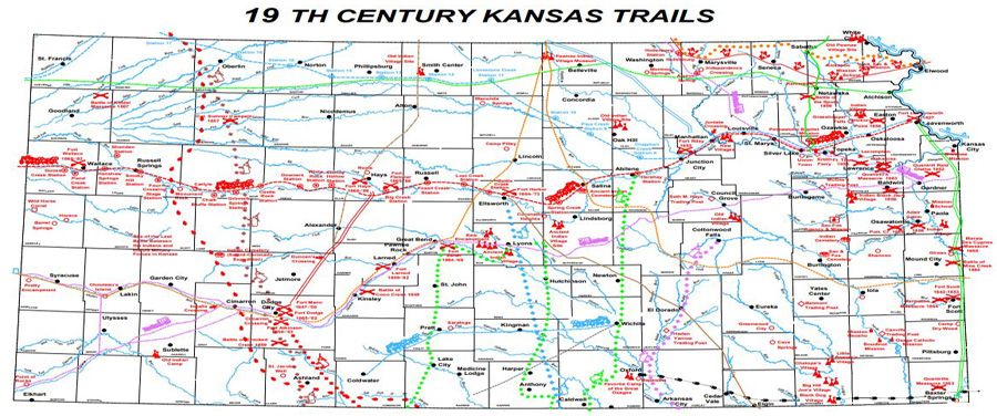
| Well known area that impeded the travel along the Sante Fe trail (courtesy of the Friends of Flint Hills) |
![]() |
| 1900 scene, of Bunker Hill West where Overland Trail coaches came in, for relief of passengers and sources (horses) |
Remarks: Modified: 12/23/2025
12/23/2025 --
TL;DR -- Today we saw an old photo of a sketch which shows part of Bunker Hill West in the 1870s. That's early enough to be before lots of the changes introduced over the long span of US history. The English culture took over in 1847 from that of New Spain. And so, the area has lots of offer with respect to our interest in the long reach of New England.
--
Here we go with a post on LA, again. Yesterday, as we looked at New France and New Spain, we mentioned Bunker Hill West. In the early days, the hill overlooked bustling LA. Then, people built upon the hill. They tunneled under it to start to build on the other side. It was partly lowered starting in the 1960s. Now long after, the skyscrapers started to appear with the first one right by the Library which is about as old as the LA City Hall.
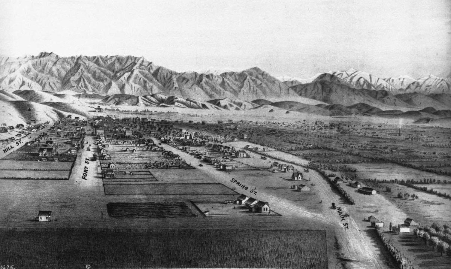
This pointer is to a search on Los Angeles within our blog. There may be Bunker Hill posts that did not come up on the list. In any case, the below photo which is courtesy of the Water and Power Organization of Los Angeles, CA is from a sketch near what is now 9th Street looking north. To orient the view, the well-known City Hall is between Spring and Main Streets (shown converging here) eight blocks north above 1st Street.
To the middle below the foothills is where one would find The Cathedral of the Angeles, not built yet. The train station is north of that.
Of interest today are the hills on the left. If one follows the Fort Street line (left of Spring Street) up toward the hills to north, there is a building standing above the city. That was Fort Moore. Going to the left, one can see parts of Bunker Hill West.
Prior posts had some information about the history of development of the hill. Today, we wanted to show a view indicating that there was a hill of size. According to Wikipedia, the elevation was up to 200 feet above Los Angeles. Naturally, there are higher hills including the massive 14k-foot mountain within a morning's drive seen on the upper right.
The Bunker Hill represents history, pre-US and post the events of 250 years ago. In this area, the culture changed several times in a manner that is representative of the changes in the US. The current stature of Bunker Hill is obvious in the photos of LA. The majority of the skyscrapers have their footing on the scraped down and leveled heights of the hill.
---
Caption of the photo: (ca. 1873)* – Panoramic sketch looking north toward downtown Los Angeles showing mostly undeveloped land. At lower-right can be seen the junction of Main and Spring streets at a point where 9th Street will one day intersect. Hill Street and Fort Street (later Broadway) are on the left. The Verdugo Hills and snow-capped San Gabriel Mountains can be seen in the distance. Photo of a lithograph, courtesy of the California Historical Society.
![]() |
| DTLA, 1873 |
Remarks: Modified: 12/23/2025
10/11/2025 - Water and Power has a whole page of photos from Bunker Hill West from the 1930s onward, including many areas compared with photos from then and now.
TL;DR -- We take modern travel for granted. To wit, the Delta recoil from the Microsoft fail just a week ago. Now, we can look at the details, and ought to. As well, let's ponder three weeks of travel back in the good old days.
--
Having just written on Los Angeles and then finding more information on the California Trail to which travelers on the Oregon Trail switched if they were headed to the Great State of California. Per usual, everywhere we look in the US, we seek out connections to New England.
A recent focus on Bunker Hill West brought to fore lots of information about people from the east coast and their activities on the left coast. For the record, this area in downtown LA is where we now find the skyscrapers. But, under many of those are destroyed records of, at least, two cultural developments. Fortunately, there is an association in LA that has photos and records about the different eras and areas.
That will be a regular theme along with technology which comes into play due to the potential for mischief. Already, we have seen photos that seem to have been generated by methods other than a human with photoshop or the like. We're not paying close attention, yet, as there are plenty of photos for study from the repositories that are available.
On the other hand, tales of people abound and mostly are not known. Technology, you see, can be a boon as it will help document the past better than we have ever seen.
Case in point, in the graphic on the left, I made the connection between a middle piece of the US with a Gardner name. It was on the Oregon/California and Santa Fe Trails. At the same time, I knew of Butterfield for a long while but only paid attention of late as the researching of New England's diaspora came to be aided by technology. Butterfield's stage line went from St Louis MO down through TX into NM and AZ and onto CA and arrived in LA after three weeks. From there, it was another week plus to SF. Nowadays, that is a little more than a five-hour drive.
In the graphic below, the bottom middle view has two lines in red on the left. Both represent three weeks. Nowadays, that's not so long. But, if you worked 21 days without a break, you would feel it.
The shorter line goes back to the top of the graphic which is the route from Independence Mo to Ft Larned KS. Nowadays, that's less than a five-hour drive. Earlier, we had a tale of the founders of Lawrence KS, including women, from Massassachuets who traversed that same route in 1854. The trip was to found the town and the University at Lawrence. Most returned to New England after the al fresco meeting leaving a hearty crew to carry on with the settlement.
And, it was in the summer. They only had to do one fording of a river which is not large (the Wakarusa). Now, following the route to Santa Fe through Ft Larned has lots of these.
Now, on the right, one sees a line from Boston to London. Three weeks. When on things of that time span, what could one do? Well, that voyage took a bit of time in the past. But, nowadays, a week is sufficient for a modern cruise liner to make the trip. So, three weeks would be three trips from Boston to London, a return trip, and then back to London. Let's say after that, one would spend 7 hours or so flying back to New England. We need to think of other examples.
As the modern analysis show, One can drive the same route from St. Louis MO to San Franciscso CA in about 39 hours. Most of that would be on the U.S. Interstate system. I have driven that a lot.
That brings up another three weeks. This Butterfield route tied in with one from San Antonio TX. From there to El Paso took about the same amount of time. See, Pre-Civil War, San Antonio to San Diego (2021). This was a combination of two routes.
Now, the top part of the image is of a wagon train pulled mostly by oxen. In the bottom part is of a coach pulled by horses. Consider the logistic for this, as horses needed to be replaced and cared for while they recovered for their next trip. People had to be fed, and other supplies would have been essential.
Supposedly, this is a photo of a Butterfield stage arriving in LA. On the first trip. a report rode the whole way. We need to find that article. See this post: Mirror Building (2023).
TL;DR -- Getting to Oregon, however done, was arduous. Today, we look at the land routes and note that the ordeals are subject of studies and have been for over a century.
--
Oregon is in the west, nestled above California. They respect their history ought there so preservation of material is a common theme. Recently, the Oregon-California Trails Association had their meeting.There were several ways to get to the west coast and Oregon from New England. We covered the water route in several posts and articles: The Gardiner that was (2018). Gardiner's barque left Boston in July of 1849 and got to San Francisco in January of 1850. It had passengers and sold its freight at the harbor. There was a subsequent voyage to New Zealand. In October of 1850, the barque (Bostonian) wrecked along the Oregon Coast.
Family members went out another route which was descent to Panama, getting across to the Pacific, and taking another ship north. The return trip was as arduous. We'll look at that further at some point.
We have written a lot about the land route. As, for a while, the trail went through Gardner, KS (3 Trails, 2019) where it split with the Santa Fe Trail. Over time, as people got familiar with the Kansas City area, they ventured north on the Missouri River to where they could cut out KS and go through NE. This saved a few days.
Young bucks in high fever were in a hurry to get to the gold field.
On the journey through Nebraska, the traffic went by Scotts Bluff (Facebook). For now, we put in a photo of the new and the old way which is apropos. People still ride the trail; one of the east-west Interstate Highways runs through the area. So, a brief nod to technology.
![]() |
| Eagle Rock and a solar car, 2022 |
TL;DR -- We continue to look at CA via two cities in order to learn more about the Spanish period that preceded the entry of New England's influence into the area. Period photos are the enabling technology.
--
We have been looking at two CA cities, LA and SF. Early on, we had Jedediah Strong Smith representing the eastern culture in his wanderings across that country. He was there in the 1830s. Later, we looked at the Butterfield Express which brought people, goods and mail from St. Louis, MO and from points in between, such as TX and AZ, to LA and onward to SF. This was in the 1850s and was quite successful despite the arduous nature of the trip. However, the Civil War interrupted the business for a few years, but post that conflict things boomed again.
There were several motivations for looking at this area of the country which include the early explorations when it was a territory of Spain, then the initial comings and goings by sea and land, the acceleration of the New England influence after the Civil War, and, in particular, an area of DTLA that was known as Bunker Hill. As we have mentioned, it now is full of sky scrapers (high-rise corner), but the area represents changes that were fast and furious over the years. However, a huge change was the introduction of the railroad across the country. We can read of this: Samuel Clemens took the trip by stage coach; later, R. W. Emerson took a similar trip by rail. Clemens disliked the journey so much that he returned to the east coast by sea which was no mean feat either.
W e have mentioned, before, the Cathedral (St. Vibiana's) that moved from the base of Bunker Hill to being on top in the latter part of the 1900s as urban renewal took its toll. The older building still stands, near the LA City Hall and serves the function of an event center. Today, we saw an early photo which was from before the time that the Cathedral was built. It is a smaller Catholic church with an interesting history with respect to our continuing studies of the other colonial experiences in the founding of the U.S.
Before going further, let's pause to recognize and honor the work of the Water and Power Associates (WPA) which has collected photos related to the history of Los Angeles. This is their mission statement:
to inform and educate its memberrs, public officials, and the general public on critical water and energy issues affecting the citizens of Los Angeles, Southern California and the State of California.
The below photos and information are courtesy of their virtual museum and collection of period photos.
---
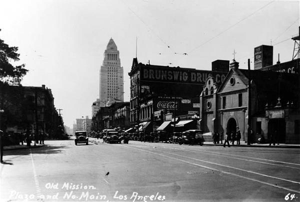
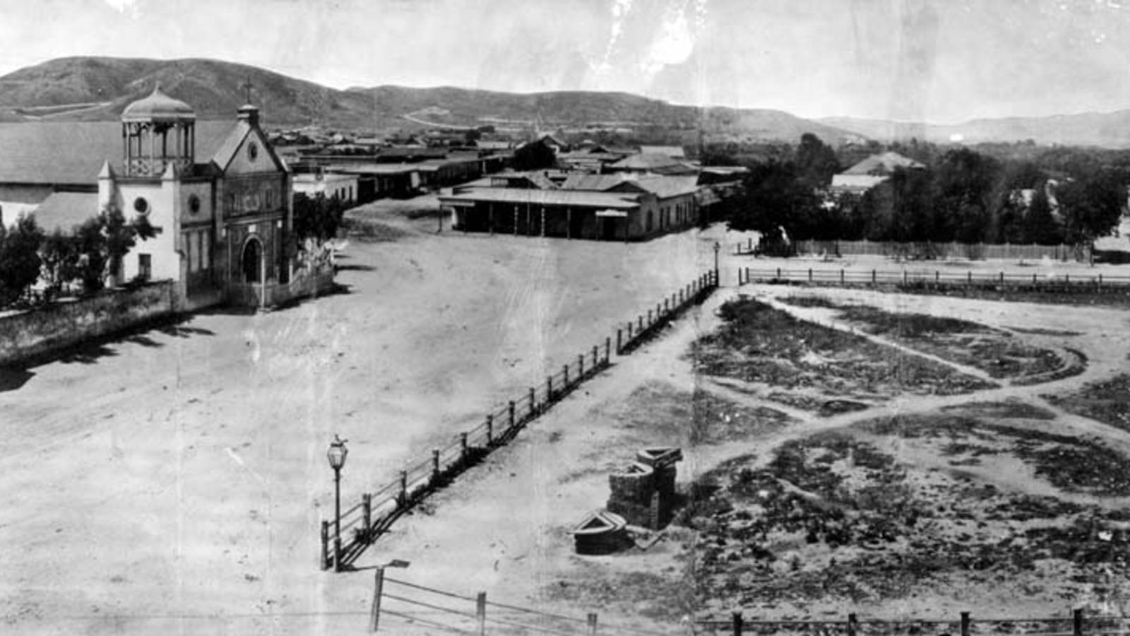
We start by looking at an earlier church (La Iglesia de Nuestra Señora la Reina de los Ángeles - Wikipedia). It is on the left of this photo that looks north on the Calle Principal which is now Main Street (Wikipedia) and which has been mentioned many times. We can consider the area to be at the foot of hills to the west of DTLA such as Bunker Hill.
![]() |
| Old Plaza Church |
![]() |
| Zanja Madre |
The "Old Plaza Church" facing the Plaza, 1869. The brick reservoir in the middle of the Plaza was the original terminus of the Zanja Madre.
As mentioned, LA is a very dry place. So, water was brought in early and has continued to be of concern as the population abounded, and still abounds, almost without bounds.
But, in the beginning:
When researching Jedediah's experiences, we looked briefly at the military aspect of the community. The Old Plaza Church and St. Vibiana's are examples of the religious. In some of the early photos that we show below there were other churches appearing as New England's influence grew. But, for now, let's look at travel and trade, again. Butterfield is mentioned in one of these photos.The Pueblo de Los Angeles was an official settlement of Spain. They had three types of settlements in Alta California: presidio (military), mission (religious) and pueblo (civil). The pueblos would provide the commercial and agricultural needs of the military as an alternative to the missions. (source Wikipedia)
The Overland Mail Company operated by John Butterfield (the founder of American Express) rented space for a station until it built new quarters in 1860 at Second and Spring--the present location of Mirror Building. The Wells, Fargo and Company also had their office here and Phineas Banning (Wikipedia) operated coaches to Wilmington and San Bernardino from the hotel.
![]() |
| Fort Moore Hill to the west of the Old Plaza Church |
Fort Hill (also known as Fort Moore Hill) was a prominent hill overlooking the pueblo of Los Angeles. Its commanding view of the city made it a strategic location.Fort Moore was an historic U.S. Military Fort during the Mexican–American War. Its approximate location was at what is now the Hollywood Freeway near the intersection of North Hill Street and West Cesar Chavez Avenue, downtown. The hill on which it was built became known as Fort Moore Hill, most of which was removed in 1949 for construction of the freeway. The hill was located one block north of Temple Street and a short distance south of present day Cesar Chavez Avenue, between the Los Angeles Civic Center and Chinatown.The fort is now memorialized by the Fort Moore Pioneer Memorial, 451 North Hill Street.
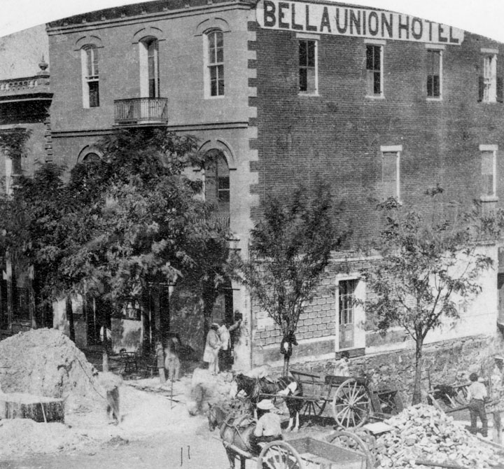
![]() |
| 1865 view after addition to 1835 building of Isaac Williams (Wikipedia) |
The Bella Union Hotel was considered the first hotel in Los Angeles. It became the Clarenden in 1873 and the St. Charles in 1875.Constructed in 1835 as the home of Isaac Williams, a New England merchant who moved to Los Angeles three years earlier, the one story adobe became the last capitol of Alta California during the Mexican era when Governor Pio Pico purchased it for his office.After the conquest of Los Angeles by American forces in 1847, the building was used by Lt. Archibald Gillespie, who commanded the occupying forces. Later it housed American troops, and after they left, it became a saloon. By early 1850, the building was operating as the Bella Union Hotel. Later that year, it became the county's first courthouse and beginning in 1858, it was the region's transportation hub. The Overland Mail Company operated by John Butterfield (the founder of American Express) rented space for a station until it built new quarters in 1860 at Second and Spring--the present location of Mirror Building. The Wells, Fargo and Company also had their office here and Phineas Banning operated coaches to Wilmington and San Bernardino from the hotel.
On October 7, 1858, the first Butterfield Overland Mail stagecoach from the East, arrived 21 days after leaving St. Louis, Missouri. "Warren Hall was the driver, and Waterman Ormsby, a reporter, the only through passenger. In that era it was the region's transportation hub: Wells, Fargo & Co. and Phineas Banning's coaches to and from Wilmington and San Bernardino had offices there.
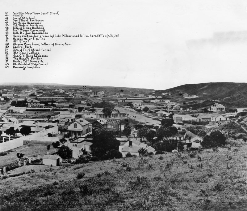
![]() |
| Labeled photo, 1869 |
TL;DR -- So, what happened in 2023? Lots. The world has changed, and it has not. People showed their seemingly limitless capacity to bow to the machine.
---
This post serves two purposes. For one, it looks at AI (usual sense) over the past year and collects material pertinent to ongoing discussion and work. The first list contains links with some commentary for each of item. This collection points to different periods over the last year. OpenAI made their announcement on 30 Nov 2022. At that time, we had these two posts which pertained to our continuing topics of research which includes technology.The image shows a copy of the "All time, popular" count by post. The topmost, related to the marriage of Thomas and Margaret, comes from the 2014 timeframe. The next one is 2021 as is the one titled "St Louis MO to San Francisco CA" which has spawned several of posts and discussions. The "San Francisco" post is from 2023.
So, we will continue this area of research as there is plenty questions that are open. Our FAQ will be updated in 2023 to account for new information. In the post titled "A(rtificial) I(Intelligence) researched properly", we go through our own work over the past decade and make some predictions about the future. Given that this work carries on prior research allows a longer time frame that seems to be normal now. So, we will continue to describe things from the historical viewpoint, both technolically and phenomenonally (which is how we view the U.S.).
Disclosure: We did not get involved with the xnn/LMM, generative material until after a couple of months had elapsed. As noted above, our timeframe is much longer than normal; and, we need to slow things down in order to establish a little bit of maturity. All of this will be discussed.
So, going forward, the second list deals with the major change in 2023. We will also use this to start a summarization of our positions on the subjects. The list follows a sequential timeline and uses posts from this blog and related material.
Remarks: Modified: 04/04/2025
12/28/2024 -- See updates in GB, XIV, 1 for 2024 updates.
04/04/2025 -- David T. Gardner has been exercisting Grok with prompts and reports finding documents that support his claim about Wyllym Gardynyr (see King Slayer Court blog). ... We have begun to incorporate changes into the structure and context of the blog. See Restart, somewhat.
TL;DR -- Oregon is right above California. We have looked at the lower State of late. Time to raise the focus to the north. Many people, for decades, got to the western State across the land. Some went by ship. Some even came down from Canada.
--
![]() |
| Oregon Trail (Wikipedia) |
For a good while, the upper boundary of the U.S. in the region was not settled. Early visitors from the U.S. were mountain men (trappers) after fur. Jedediah Strong Smith was in the region in the 1820s.
Some arrived by ship from the east coast, especially after the Gold Rush moved north from California. We researched that with respect to the Barque Bostonian that wrecked along the Oregon coast in 1850 after leaving Boston in July of 1849 and arriving in San Francisco early the next year.
Many posts were about the trails that early on went through Gardner KS. That lower traffic went by the location of the University of Kansas in Lawrence. The upper traffic sped up the trip a few days and was pioneered by the youngsters who were in a hurry. Rather than cross the river and head via land from Independence MO, the travelers went up river past St. Joseph MO to Nebraska and went west where they met those coming up from the lower trail.
There are several subjects to touch upon. Many pioneers to Oregon were from New England. However, many of these travelers were new to the country and following Horace Greeley's advice to "go west" which he did himself.
We recently saw this service advertised: Oregon Trail Genealogy.
06/14/2023 --
TL;DR -- Our first bit of tasks dealt with learning about New England, especially little Essex County of MA. Later, we considered movement away from that area either to the south or to the west. And, by water, too, as that traffic had been constant from the beginning. After the Revolution and Lewis & Clark's journey, the expansion started in earnest. However, the interior of the U.S. is huge and took a while to be carved up. Travel across the country took time by land. And work. Too, water travel was full of its travails. With the 400th from the beginning, the 250th coming up relates to the U.S. being populated. California will get a little more focus as it is first by many categories.
---
Our first mention of the Golden State was in 2015 which is the sixth year after the blog had its first post. It was a brief mention as we researched the Barque Bostonian owned by Henry Gardiner that wrecked in Oregon. The ship had been in San Francisco prior to that. But, we found out that it had also been in New Zealand and a number of other places.
Then, about that time, while being at a lavender farm near Lawrence, KS and realizing that the trails had passed through that area, the thought was: did the students up on Mount Oread see the trekkers as they labored past? The post: Gardner KS (11 Aug 2015). We had seen signs while traveling but were overwhelmed with learning New England particularities. Even little Essex County was unknown to us and took some time for study. A year later, we started to update the information dealing with the western movement (Gardner Junction).
Of course, given the drive to get to the gold rush as fast as possible, the CA traffic dwindled after the young guys figured that going up the Missouri River past St. Joseph saved them a few days. Rather than the circuitous route into upper KS and then heading northwest to NE, they just got off the boat and joined the trail goers after a shorter jaunt. But, traffic to the southwest (Santa Fe) still went through Gardner, KS as did some going to CO first and then joining the OR/CA trail in Wyoming.
That deals with movement by land. While researching the early venturers (mountain men, trappers), we looked at CA, too, principally. Though, Jedediah Strong Smith got there in 1826 and was the first European to go across the Mojave desert (even doing so in the summer). Then, he mapped out the Interstate system with his wanderings before coming back to meet his demise in the Great Plains region. Along with and after him, there were other travelers that we looked at.
But, there is an area that we have avoided, to dated. How did CA end up with its 1850 entry into the U.S.? For this historic portion, we will use documents published by the U.S. By 1847, the area of California was home to 150K indigenous people plus about 14K folks of European ancestry. Most of the Europeans lived south of Monterey, especially Los Angeles. San Francisco (then Yerba Buena) had a scattering, until after the 1848 discovery of gold at Sutter's who had arrived in 1838. In 1849, 100K additional people arrived from the U.S. and Australia, New Zealand and Hawaii.
We will back up and look further at New Spain in California. Mexico had won its Independence in 1821. As well, we will look into the lives of the indigenous folks prior to and after the arrival of the Europeans.
There will be more posts on this and other states. As well as New England States and Missouri, we have looked at Virginia, Kentucky, Ohio and Michigan which got started after the Revolution, mostly by restless veterans. So, we will cover the States, interior and along the coast lines.
Remarks: Modified: 04/28/2023
04/28/2023 --
TL;DR -- Supposedly, the phrase associated with "Go west" is attributed to Horace Greeley. While researching, we found that Horace had gone west, prior to the Civil War. He did it cross country and wrote of the journey in detail. This information pertains to our current time and issues; as such, it is worthy of our attention.
--
In an earlier post, we looked at two cousins, one of which was Adolphus Greeley and the other was USN Captain George William Coffin. They met in the Artic as the latter rescued the former who had been stranded with the crew of his Lady Franklin Bay Expedition.
A generation earlier, we have another name, Horace Greeley who shares ancestors with Adolphus. Too, Horace journeyed west prior to the Civil War. We ran into his correspondence while researching the historic weather of Donner Pass with respect to the California Trail as this topic is part of our interest in the western expansion and the related trails that crossed the vast interior of the country.
As an aside, this winter's total snowfall will set a new record.
Before getting into the gist, we provide profiles for Horace (WikiTree, Wikipedia) and Adolphus (WikiTree, Wikipedia) Greeley. Also, we provide more information on George William Coffin who was a graduate of the U.S. Naval Academy and served in the U.S. Navy.
---
Along with information about trails and passes, we ran into an on-line copy of Horace's book on his trip: An Overland Journey from New York to San Francisco (1860). His journey started in New York by rail and boat until he reached St. Joseph, MO. Until others who headed off west on the trails, Horace went down to Kansas for a Republican Convention at Osawatomie, KS. He mentions going through Lawrence which whose settlement was supported by The New England Emigrant Aid Company. The Convention was on the 18th of May in 1859 (Miami County). This chapter of the book was submitted from Atchison, KS on May 15th.
His book has thirty-four Chapters of which more than ten are on Kansas, the Plains, the Desert, and gold. These will be of interest as we pursue the history of the U.S. and its interior. He heads west out of Denver by jaunting up to Fort Laramie (Chapter 16) and then west to Utah. Several Chapters deal with Salt Lake City and the area. And, he provides several views of California (Chapters 27 to 33). His final Chapter looks at traffic into and out of San Francisco and discusses the need for a railroad.In our post, St. Louis MO to San Francisco CA, we describe the route from St. Louis down into Texas and across the southern border to Los Angeles, CA and then up the coast to San Francisco. The 1860 portion (top) of this graphic shows the transportation status when Horace went west.
Horace Greeley returned by boat. For this book, his last Chapter was posted on the 9th of September of 1859.
----
Of note, this was no virtual trip. We have to match this effort up with that of the comedic guy (Samuel Clemens), later. As said, we had several posts on this theme (starting with the mountain men).
----
This story has several points of interest related to our work. This applies even to our current interest in technology and its historical impact, especially as activities of our times may portend to the future.
Remarks: Modified: 06/14/2023
06/16/2023 -- Added "Horace" to the title. He went himself.
TL;DR -- Earlier we took a look at transcontinental travel in the early 19th century and its ardors. There was nothing easy about the ordeals, but people took up the gauntlet. Here we look at one site where travelers made their presence known and link to a map that has local details of interest.
![]() |
| Click for detailed map from KDOT |
Remarks: Modified: 12/12/2022
12/11/2022 --
TL;DR -- New England has a long arm as there were two centuries along the East side prior to any attempts at expanding west. For most situations, one can find newly arrived families as well as those of various older lineages. In particular, we will focus on individuals including their business activity. A case is Butterfield who was Yankee and quite active out west. In his life, we see the impact of the Civil War. Too, we see progress via technology, such as the telegraph and the train. Butterfield did other things, but he designed a system to transport people, mail, and goods overland from St. Louis to San Francisco sweeping down through the southern regions. This was a regular activity for more than two years and deserves attention, for many reasons.
--
The 250th of the American Revolution gives us a chance to relook at history. One thing to note is that the rebellion was the onus of the 5th Generation. Post the conflict, the 6th and the 7th were involved with the fulfillment of Manifest Destiny. Of course, we will look at that, too. But, in this context, we are looking at particular periods leading up to the 20th century whereby the U.S. slowly got its bearings. As we follow the populace, we will note the state of technology and more.
Earlier, we mentioned the Butterfield Overland Express which went from St. Louis, MO to San Francisco, CA by swinging down south into Texas, ran across the bottom of NM and AZ (Tucson), went along the southern border to Los Angeles, and then up to San Francisco. We can do that trip easily now, all by Interstate Highways. The image shows the modern look with about 40 hours estimated for the trip. That means that drivers switching off would make the trip in two days (see map, courtesy of Google maps).
As an aside, flying now from STL to SFO is a little over four hours. Also, there are faster modes by air.
Even though part of the Butterfield route ran from 1849 until 1882 when the railroad offered a better means, the Civil War interrupted the pattern in 1861. This was a regular run by a system that employed people and animals and required equipment. The organizational work must have been mind-boggling with little communication means beyond telegraph. The Schedule for Sept 16, 1858 (available on-line) laid out the route, the time, and discusses some of the particulars (see following image) about the company and its mission.![]() |
| Butterfield: Miles, Hours (from SF to StL) |
On looking further at John, we found that he was involved with the start of American Express, too, with two other New Englanders, Henry Wells (WikiTree profile of Henry) and William George Fargo (WikiTree profile of William). Yes, Wells and Fargo established Wells Fargo (their motif was a stagecoach with horses) in San Francisco during this period.
As the country expanded, the need for business communication increased all around. Too, the U.S. Postmaster General had the responsibilities for mails and used companies. AmEx started in Buffalo, NY in 1850 but established itself in Manhattan, NY before too long. It's focus became financial express.
As people spread west, there was a corresponding need for personal, as well as business, mail. And, delivery was a growing business. Another business model involved moving people with coaches. Hence, the need for the overland express. Of those available at the time, the Postmaster General decided that Butterfield's express was the most capable.
At the time, there was a more northern route (Central Overland California and Pikes Peak Express Company) which included the Pony Express. This was the means that Mark Twain used to go west and that he wrote of later. We will look further for comparative views on this subject from those who were there. The southern route, though longer, was preferred due to less hassle related to snow issues. However, in the summer, there was the opposite as part of the route was labeled El Camino del Diablo.
The Civil War interfered with the business success of these express companies. Some of the routing was moved up north while the southern route was abandoned. Fortunately, the rail system became a little transcontinental in 1869 thereby offering an improved method for this type of express from Kansas City to San Francisco and all points between That is, there was one line running across the country. Leland Stanford led these choices. It took another couple of decades to get more rail installed. These three maps indicate the rail lines in red. The west is without rail in the 1860s. Then, we see the one line of the 1870s. Finally, see 1890s which still has lots of open space in the west.
So, things were booming prior to the Civil War as the new nation got its legs. Then, the war was a huge disrupter across the board. It took another generation or two to recover. That, too, is part of the U.S. story.Remarks: Modified: 08/23/2026
06/19/2021 -- Very old St. Louis in the State of Missouri.
10/06/2022 -- Have used this post in many posts, newsletters and comment. Updated the error for the URL for the post on the Gidding's route: West Texas to Southern California
12/23/2025 -- More on the Butterfield stage as representing the U.S. government's concern for handling Overland Mail. There has been lots of research about the trail from St. Louis MO to San Francisco CA.
08/23/2026 -- Image of schedule disappeared from Wikipedia. Swapped in a snap of the divisions of the route which covered almost 3,000 miles and took almost 600 hours.