Showing posts sorted by relevance for query bent. Sort by date Show all posts

Thursday, May 27, 2021

Trapper, trader, rancher

TL;DR -- Movement to the west started early, hence the conflict with American Indians ensued which resulted in attempts at treaties. One of these attempts was at a meeting near the Little Arkansas River in 1865. The major tribes of the Plains were represented. The foremost negotiator for the U.S. was of New England. Also present was Kit Carson and William S. Bent who had an Indian wife and had spent several years in the west.  Like early treaties, this one did not take. Subsequent treaties resulted in a lessening of land available to the Tribes. 

--

Recently, we wrote of the frontier century that began after the trek of Lewis & Clark and continued until the early 1900s. The early part of the century gave us Jedediah Strong Smith and his peers. They interfaced out west with American Indians and people from New France. In this case, the movement west had been across the middle of the country. A couple decades later, there was more area covered, and we saw settlement taking hold. Some were already old, such as St. Louis MO. Others sprang up along the way and over time. For all of these periods we have identified families to research noting location and routes which included rivers. 

However, we also have looked at the time before the interest of New England changed the west. Turns out that Wikipedia is thinking along the same lines: American Frontier (article was started in 2016). 

This post looks at William S. Bent (1808-1869) who was a trapper, trader, and rancher. He built several posts along the Santa Fe trail. William was born in St. Louis, however his father, Silas Bent (1768-1827) was born in Rutland MA which is in Worcester County. Silas is of the generation too young to be a Patriot but his father was one. We will look at Silas later as he was educated in Wheeling WVA (at the time, VA) and became a surveyor of the Louisiana Territory. As can be seen, Silas shows an interesting part of the migration patterns out of New England where he had a deep pedigree. 

Missouri saw European influence early on but became a State in 1820. The image shows the Santa Fe Trial going across the middle region. William S. Bent built a fort along the northern route of the Trail in southeastern CO in 1833. The southern route of the Trail continued in KS in OK and then NM. It was along this route that Jedediah was killed. 


William was out in CO for several years and had a ranch. He bought land near Kansas City MO in 1858. He married the daughter of Cheyenne leader. There will be a lot more to look at as that whole area boomed over the next decade and one-half. 

In 1865 as the Civil War was dying down, the U.S. government developed a Peace Treaty with the American Indians and organized a signing ceremony. The tribes involved were the Apache, Arapaho, Cheyenne, Comanche, and Kiowa. This meeting took place near current day Wichita KS. 

William Bent was there for the signing of the Little Arkansas Treaty which is named for a tributary of the Arkansas River that originates in CO. William had been involved with the American Indians for several treaties: 1840, 1848, and 1861. There were many more in succeeding years. 

The treaty's text is available via Yale's Avalon Project: Treaty with the Apache, Cheyenne, and Arapaho; October 17, 1865. The Daughters of the American Revolution placed a marker in 1925 to honor the event (more details later). 

We wanted to mention a few of the others who were there representing the U.S. due to their connection with New England, both north and south. As we read of this, we saw a Sanborn name pop up, so that got our interest. 
  • John B. Sanborn - born in New Hampshire. John went to Dartmouth and ventured out to Minnesota in 1854. He served with a Minnesota military unit during the Civil War. After that, he got involved with the western frontier. 
  • Kit Carson - was born in Kentucky to a Patriot of the Revolution and 1812. His family moved out to MO and were friends with Daniel Boone. By 1826, Kit had gone west on the Trail and was all over the west. Even a summary would be too long for now. So, we'll look at him from time to time. 
  • William S. Harney - served in the U.S. Army from 1818 to 1863. President Johnson appointed him to the Indian Peace Commission. He was born in Tennessee in 1800, but his father was an officer in the U.S. Army.
  • Jesse Henry Leavenworth - born in Danville VT, he was the son of General Henry Leavenworth who was born in New Haven CT. 
 American Indian leaders who were there are: 

Remarks: Modified: 06/19/2021

06/03/2021 -- Added the TL;DR. 

06/19/2021 -- Very old St. Louis in the State of Missouri


Thursday, August 27, 2020

US Territory

TL;DR - Military man. Went up the Mississippi to its start. Then, went out to see the Rockies. Found the source for the  Arkansas River. Had a run in with the Spaniards. So, was taken to Mexico. Sent back. The War of 1812 came up, and Zebulon Pike died. Young man. He, of several, helped us map out the western U.S. where the states can be huge.

--

Having been looking at families as they moved west, we have learned a lot with respect to history, genealogy, and life, in general. For one thing, there are people who need to be recognized for their lineage, albeit some of the genealogical bent have this bias (it's the paper that counts, silly). On the other hand, people had lives and left others behind. One consequence of the forever shift is that things get lost, like who was where.

As an aside, we know of Zebulon Pike's life. He wrote of it. After looking at Daniel Boone, we figured that we need to move further west, as Daniel stopped not far west of the Mississippi. Hence this post, as those who went west did it with labor. We'll get there in a continuation of the western movement series that started a few years ago. So, let's stop to look at the US States and some of their attributes.

After a brief pause, though. One thing that stood out in looking at early Massachusetts and New Hampshire is that someone could move, even two counties over, and be forgotten in the sense of not being included in some write up. So, it was understandable when someone went further west. Say, the Mayflower descendant out in the lonely prairie grave - see Bayes post - more coming. In his case, a book on his family starting with the 17th century arrivals just noted that he was out west. In another case, some abolitionist was hanged in Texas (pre-Civil War) for being there. We found this out by digging. Lots and lots of stories to tell; fortunately, the internet will allow a more full fleshing of history through time. So, people will be a common focus; we will set up a proof process for descendants of Thomas and Margaret; however, friends will be allowed, to boot.

So, there was a comment about Boone being known for migration on land. After all, his party went by foot from NC to TN and west out to MO. The old guy (in his 80s) is said to have taken a party out to the Yellowstone area. Pike, on the other hand, was young. He mapped the source of the Mississippi. He did the same for the Arkansas River, poorly equipped in late fall (snow of the Rockies). Then, he was taken down by the Spanish to Mexico and brought back. His travels were after Lewis & Clark and before the Santa Fe trail.

Note: we got on this theme with Jedediah Strong Smith and Judge Thompson of Massachusetts, in part.

Looking at the U.S., all of the larger states are out west. For instance, KS is 81K sq mi. This is mentioned since Col. Higginson went there explicitly to show support for John Brown. Too, it was traversed, in part, by the trails, with almost 6/8ths of the trail in KS (Santa Fe Trail). But, Pike went through the area, too, earlier (The White Man's Foot in Kansas). Lots have been written about Pike.

The largest state is Alaska with over 1/2 million sq mi. Texas is next (it'll be featured due to several connections with the East Coast, including New England). This comparison is not for bragging rights; rather, the amount of effort to go across an area relates to the distance. However, terrain was a larger factor. Drive across WV, sometime, and note the absence of any flat area. Or, what they call flat is not really.
Size of States, U.S.
The tales of the Sante Fe Trail mention that parties, sometimes, took the harder route in order to avoid conflict with the American Indian population. From a commercial view, that makes sense. We will look at that. Usually, the path of lesser resistance was taken. Say, moving from Gardner KS to above St. Joe MO in order to save a few days (the gold in CA was calling); besides, going up the MO river was easier than sloughing out west by land. Even if for a few days. Choices.

Remarks: Modified: 02/27/2021

02/27/2021 -- Changed to using American Indian. 

Thursday, June 17, 2021

Paper Trails

TL;DR -- The Economist reviewed a book that reported on research using Post Offices as a proxy for studying population and movement. The demo and its code for the project is at GitHub with Harvard providing the data repository. This is an example of a growing trend related to reproducibility through time and across region. We look at maps that show the early start and the frontier century. We will revisit the theme as we dive further into research which will also look at nautical world as well as influences other than New England. 

--

We have followed New England's influence starting with the nautical experiences and then getting into the frontier times in the west. St. Louis will be a center point for the earlier part of the westward movement since it was involved in carving up (see Bent post on surveyor father and his trapper son) the huge pieces that were obtained via the Louisiana Purchase and later acquisitions. But, there was movement inward from the left coast, too, as well as from the south (giving us Texas, the great State) and its spheres. 

So, our research focus will include, then, four centers with Salem in the east (yes, we see Winthrop as a later arrival), St. Louis in the center, San Francisco out on the left coast, and somewhere in TX as a southern point. Perhaps, San Antonio. Too, rather than the esteemed heights of the historian (academic) as the focus, we are following families, especially in regard to the middle not being flyover country

The below is motivated by an article in The Economist (How the West was won). So, there is an aura (per usual, Brits, what else?) of judgment that seemed to waft from what the verbiage expressed. Okay, we like the mag, for depth of content and humor. Also, they are talking of a book, same title as the post. Here are some links related to the book and author. 

Now, with respect to GitHub, we have referenced this several times as it pertains to the work of Gardner Research and to the notions of the digital realm (for which we propose truth engineering as a necessity). Our portal (https://TGSOC.org) is a start on the long trek required. Expect the theme to continue. 

Before going further, we want to remind everyone of the Age of Colonialism. The U.S. did not run around the world competing with Europe. Rather, we had our own internal dynamics. The look at the carving of part of the hemisphere will cover that. The nautical? Ah, business on and enabled by the sea. Boston got its Brahmins. The left coast and Texas? We'll punt that to later posts. 

We did snap of Professor Blevin's graphic at dates that are pertinent to our work. We are diving, now, into the situation at the beginning of the wild west, and a little before as we recognize New France and New Spain. We want to go to about the 1850s where the middle was being used as a cultural battleground long before the Civil War. But, the graphic also includes the beginning (1792) and a couple of snaps from the 20th century. 

This page gives details about the analysis using Post Offices. The image below was created from snaps from that page. Note: the application is hosted at GitHub. 

This is only an introductory look. At the top is 1792 when the new country was getting its legs. There is a little dot out west marked by a red arrow (New Orleans? Too early; looks more like TX and too early; so stray dot?). The next row is our current interest which involves the early surveying times (1805) and the time of regular traffic via the trails (1855). The next row is our Frontier Century snap (1811-1921). Why 1811-1921? The snap was after a stop. The years are close enough for what we are doing now. After all, 1811 is one year before 1812's turmoil. 1921 is after both WWI and the Spanish Flu. Lots happened to families between that time. 

We will get more fine-grained later. Lots to discuss there. In the last row is 1990 which is interesting when compared to the 1921 snap. As one watches the graphic, dark regions become light as POs close for any number of reasons. The thing is that the highways become visible. 

Aside, Jedediah Strong Smith gets little respect for mapping out the CA Interstates ;>). He got us aware of the long reach of New England. But, too, he was around a whole lot of other folk that we have looked at and will continue to study. 

Remarks: Modified: 06/17/2021

06/17/2021 -- Added the TL;DR. 

Tuesday, June 29, 2021

Pace of change

TL;DR -- Before getting into some technical issues, a pause to look at the quick coverage of the interior of the U.S. is in order. In the graphic, the blue are Post Offices (1855 and 1921) as they spread across the country. The red show the railroads (1860s and 1890s). We have looked at the time before technology came about. But, even when it did, there was a natural evolution of ability. In any case, the conflicts of today are nothing new, basically old stuff with nuances related to the current time. So 400 years ago may have been different in a lot of ways, but how close are the people then to what we had 100 years ago? 

--

This post briefly summarizes work that we done over the past few months, much of it looking at the interior of the U.S. We need to get technical, for a while, which will get us back to the issues of content management and more. This has been a periodic occurrence that has left traces (see discussion at our portal - https://TGSoc.org and our technical blog) which follow how things have changed during the past decade and one-half. Lots like to ride the wave (to nowhere). Civilization needs its moments of review in order to stay within sustainable practices. The computer has messed things up. But, also, we have new ways to research and report (that was one motivation for the Web which was based upon DARPA's attempting to have robust communications). We have to keep history in mind, local and global. Too, New England and the Cape Ann crew will continue to be of use to much analysis now and into the future. 

Messy now? Yes, but, we were messy before, too. We have been covering the frontier century, for various reasons. One of these is that we have run across lots of families who were early on the frontier and seemed to have lost their lineage. Of course, there were many newcomers during that century. However, there are others who were here whose families moved into states long before they were organized and so left little in the way of tracks.

We call it the lost generation (or two) which is the ones right after the Revolution. 

So, one might argue the Boones. Daniel's prominence made sure that people paid attention. For every Daniel, there are 100s and 1000s who get little in the way of notice. Yet, these people farmed, built, surveyed, and more. On that latter, the Bent family whose member was at the Treat signing in Kansas got us on that. The father was the organizer; the son was out in the wilds. The treaty didn't hold like many others. So, we'll be looking at that (1865, Little Arkansas Treaty - that's a river out of CO that runs through several states to the Mississippi).  

Along that line, we have pulled some images that bear discussion, especially when we consider the short period of time related to the phenomenon. In this case, it is still the filling in of the interior. We are now thinking of the land being carved up. And, Missouri is a good example being the first one. It's start is in parallel with Maine's. Look at that juxtaposition. As well, the crew coming into Essex County, MA had to get things organized including surveying. Thomas and sons helped with that. John was with the Merrimack crew. In that time, late 1830s, he did learn more than those ones at Harvard. Lots to discuss there. 

Ponder this image which comes from two sources: Paper Trails (on the left); St. Louis, MO to San Francisco, CA (on the right). The left column shows the number of Post Offices at two times (1855 and 1921). The right shows the railroads, similarly (1860s and 1890s).

The times are meant to cover a 1/2 century what was from just before the Civil War of the U.S. to around the WWI timeframe. Got that? Internal conflict was the theme of that earlier turmoil. Actually, is. How are we any different? And the latter? The U.S. on the world stage in the context of trying to resolve conflict over there which was of long running, to boot. 

Getting back to the timing of those looks, on the left, notice the heavy coverage in the east coast with the sparse dots out west. On the right, notice that the railroad may have been somewhat out to the Mississippi in the 1860s but definitely not the west. A mere three decades later, the railroad did go across the county. For the Post Offices, by 1921, they were everywhere that people were. Those huge white areas are uninhabitable. Or, folks there know that they have to go pick up their mail. 

After all, in that top-left situation, mail went west by coach (several ways), the pony express, or by water (a couple of ways). That in itself is an interesting subject that we need to keep the youngsters aware of. 

On the other hand, with respect to the railroads, that 1890s coverage was quite impressive. And, it allowed faster population of the areas. 

About internal conflict, the Civil War was no cessation. Conflict with the American Indian continued for a long time leaving a situation where the reservation mode under the guidance of Washington DC was the reality for tribes. Lots to look at there. 

In short, in one-half of a century, again, the U.S. covered an area that is huge. Folks back east with their notions of wilderness have no idea about the frontier. Genealogists, are you listening? Let's step into modern modes (beyond genetics and microbiology) a little more. 

Remarks: Modified: 06/29/2021

06/29/2021 --  

Friday, January 14, 2022

Four-masted barque rounding Cape Horn

TL;DR -- Captain Johnson filmed his voyage, as a young seaman, rounding Cape Horn in a barque. That was 1928. He narrated the film in 1980. The film has so much to discuss. It's clearly an example of something that could be used to talk sides of several issues. Young people using their muscle and brains? Yes, 'meta' verse as some paragon? Hah. Seafaring has some appeal beyond normal. But, that work of keeping the ship going represents lots and lots of work done prior to now, being done now, and to be done (robots? silly, to the max). Oh yes, phenomenal notions and thoughts of existential aspects are very much to be brought forth. 

--

Of late, we were in a landlubber mode which can be the natural bent of the soldier. Albeit, the U.S. Army once exulted in having more watercraft than the U.S. Navy and more aircraft than the U.S. Air Force. But, we had a good reason for our focus: the Great Interior of the U.S which was carved for over a century. There have been many posts on this theme where we can use Sam Dunn's look as a basis. 

As said, we would get back to the seafaring mode (say whaling, Gardner Jonah) as that was one way of New England. Salem, MA, like other coastal towns, excelled in shipping (John Lowell Gardner, I) and shipbuilding (Shipwrighting, USS Merrimack). Shipping companies had lots of vessels as the article on John Lowell Gardners shows. Some of these were barques which were highly efficient, in speed and capacity. We looked into that a little while researching the owners of the barque Bostonian that wrecked off the coast of Oregon in 1850. It had left Boston the year before, got to San Francisco, ventured over to New Zealand and was going north from San Francisco to deliver supplies to miners. The owner, Henry D. Gardiner was a descendant of George Gardiner of Rhode Island, however his two wives were descendants of Thomas Gardner of Salem. In our research, we look for those associations, including Gardner, Essex County, Massachusetts or New England. Lots of research still to do. 

There have been many written reports on sailing and ventures thereby as well as problems, such as that of the Essex out of Nantucket. But, film/video is recent. As well, many renditions are fictional, made later. Or, they are something similar. 

Today, we found this which is phenomenally apropos for several reasons. The film was of a voyage of a Four Masted Barque rounding Cape Horn (via Mystic Seaport Museum, Inc.) that was filmed by a young sailor in 1928. He later narrated the film in 1980. The file starts in the North Sea. The narrator talks about specifics of the work of managing a large vessel such as this. He talks of the physical labor involved. Notice, not complains, describes. This was before hydraulic assists and other modern conveniences. 

As the old guy says, why sign up for such misery? Well, the thrills and the joys of sailing. We could add doing such over a large ocean with sun rises and sets. Plus, no voyage would ever be the same as another. To, the demanding work had to be satisfying; as the narrator said, you did what you had to do to keep the ship healthy.  

If can this wasn't heard: in bad weather, four on and four off. Too, notice no gloves or safety equipment. One learned to be careful. Also, there are several copies of this film in museums. He gave a talk in London to insurance people. One remark that he heard was that dozens of other vessels would not have made it through the voyage. 

The film is so rich of memes (not stupid computer-based thingees, no real life) that we could talk forever, almost, about how this could be used to bridge the real world and that of the pretend, even if it supposedly augments the world of today's pampered lives. 

Remarks: Modified: 01/15/2022

01/15/2022 -- Add links to the Mystic Seaport Museum and a post on Capt. Edmund Gardner, the Gardner Jonah. 

Wednesday, May 1, 2024

Old L.A. and the U.S.

TL;DR -- We continue to look at CA via two cities in order to learn more about the Spanish period that preceded the entry of New England's influence into the area. Period photos are the enabling technology. 

--

We have been looking at two CA cities, LA and SF. Early on, we had Jedediah Strong Smith representing the eastern culture in his wanderings across that country. He was there in the 1830s. Later, we looked at the Butterfield Express which brought people, goods and mail from St. Louis, MO and from points in between, such as TX and AZ, to LA and onward to SF. This was in the 1850s and was quite successful despite the arduous nature of the trip. However, the Civil War interrupted the business for a few years, but post that conflict things boomed again. 

There were several motivations for looking at this area of the country which include the early explorations when it was a territory of Spain, then the initial comings and goings by sea and land, the acceleration of the New England influence after the Civil War, and, in particular, an area of DTLA that was known as Bunker Hill. As we have mentioned, it now is full of sky scrapers (high-rise corner), but the area represents changes that were fast and furious over the years. However, a huge change was the introduction of the railroad across the country. We can read of this: Samuel Clemens took the trip by stage coach; later, R. W. Emerson took a similar trip by rail. Clemens disliked the journey so much that he returned to the east coast by sea which was no mean feat either.  

W e have mentioned, before, the Cathedral (St. Vibiana's) that moved from the base of Bunker Hill to being on top in the latter part of the 1900s as urban renewal took its toll. The older building still stands, near the LA City Hall and serves the function of an event center. Today, we saw an early photo which was from before the time that the Cathedral was built. It is a smaller Catholic church with an interesting history with respect to our continuing studies of the other colonial experiences in the founding of the U.S.  

Before going further, let's pause to recognize and honor the work of the Water and Power Associates (WPA) which has collected photos related to the history of Los Angeles. This is their mission statement: 

to inform and educate its memberrs, public officials, and the general public on critical water and energy issues affecting the citizens of Los Angeles, Southern California and the State of California.

The below photos and information are courtesy of their virtual museum and collection of period photos. 

---

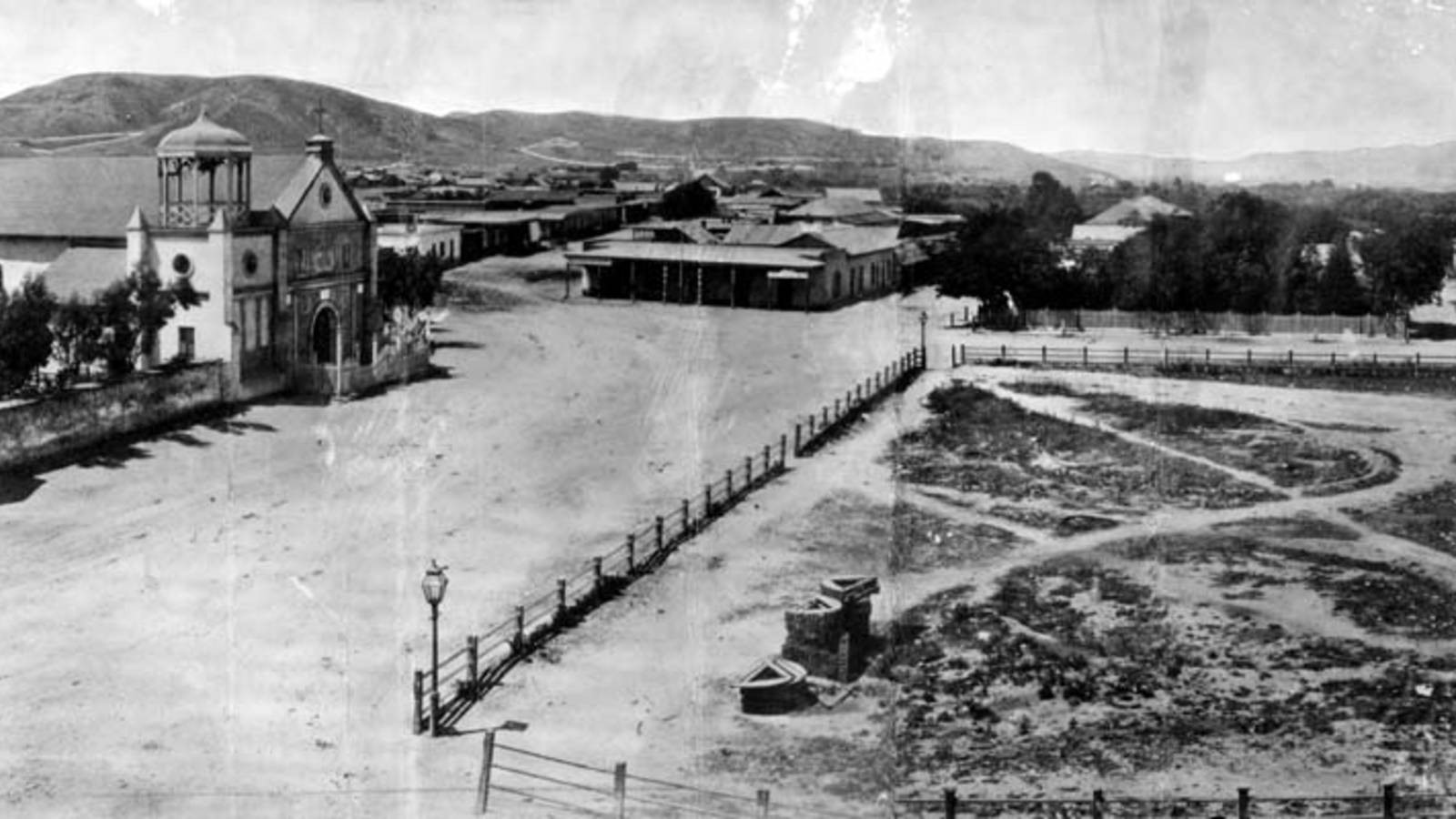
We start by looking at an earlier church (La Iglesia de Nuestra Señora la Reina de los Ángeles - Wikipedia). It is on the left of this photo that looks north on the Calle Principal which is now Main Street (Wikipedia) and which has been mentioned many times. We can consider the area to be at the foot of hills to the west of DTLA such as Bunker Hill. 

Old Plaza Church 

Zanja Madre
The caption for the photo at the WPA site mentions the "Mother Trench" (Wikipedia) with this caption:

The "Old Plaza Church" facing the Plaza, 1869. The brick reservoir in the middle of the Plaza was the original terminus of the Zanja Madre.

As mentioned, LA is a very dry place. So, water was brought in early and has continued to be of concern as the population abounded, and still abounds, almost without bounds. 

But, in the beginning: 

The Pueblo de Los Angeles was an official settlement of Spain. They had three types of settlements in Alta California: presidio (military), mission (religious) and pueblo (civil). The pueblos would provide the commercial and agricultural needs of the military as an alternative to the missions. (source Wikipedia) 

When researching Jedediah's experiences, we looked briefly at the military aspect of the community. The Old Plaza Church and St. Vibiana's are examples of the religious. In some of the early photos that we show below there were other churches appearing as New England's influence grew. But, for now, let's look at travel and trade, again. Butterfield is mentioned in one of these photos. 

Old Plaza Church
and the LA City Hall

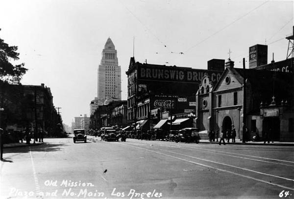
In our earlier look, we mentioned how his coaches came into the area where the Times-Mirror building is now. Let's use a photo of Main Street looking south to set the dimensions. The photo is from 1928 which was not long after City Hall was finished. We see that the civic building is just down the street from the church. 

And, the facilities used by Butterfield (and his cohorts) would have been just on the other side of the City Hall from the church. 

Quoting the WPA site: 

The Overland Mail Company operated by John Butterfield (the founder of American Express) rented space for a station until it built new quarters in 1860 at Second and Spring--the present location of Mirror Building. The Wells, Fargo and Company also had their office here and Phineas Banning (Wikipedia) operated coaches to Wilmington and San Bernardino from the hotel.

But, that brings up another view to consider. We will be looking more at the history of Bunker Hill, eventually. It is just south of Fort Moore Hill which is in the background of the church in this photo. From this perspective, one can see why there was an effort to tunnel through these hills to go west. 

Fort Moore Hill to 
the west of the 
Old Plaza Church

The PWA site on Fort Moore hill: 

Fort Hill (also known as Fort Moore Hill) was a prominent hill overlooking the pueblo of Los Angeles. Its commanding view of the city made it a strategic location.

Fort Moore was an historic U.S. Military Fort during the Mexican–American War. Its approximate location was at what is now the Hollywood Freeway near the intersection of North Hill Street and West Cesar Chavez Avenue, downtown. The hill on which it was built became known as Fort Moore Hill, most of which was removed in 1949 for construction of the freeway. The hill was located one block north of Temple Street and a short distance south of present day Cesar Chavez Avenue, between the Los Angeles Civic Center and Chinatown.

The fort is now memorialized by the Fort Moore Pioneer Memorial, 451 North Hill Street.

----

Now, getting back to Butterfield, the building where he started was built in 1835. That is very early as the area was still under Spanish control. This next photo is from 1865 and shows the state of the building after additional floors were constructed. 
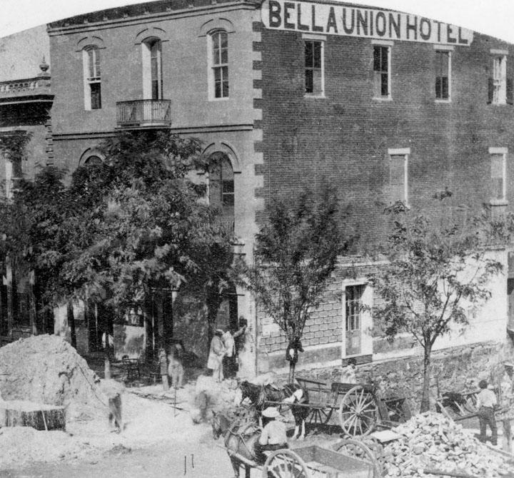
1865 view after
addition to 1835 building of
Isaac Williams (Wikipedia)

Quoting the PWA site: 

The Bella Union Hotel was considered the first hotel in Los Angeles. It became the Clarenden in 1873 and the St. Charles in 1875.

Constructed in 1835 as the home of Isaac Williams, a New England merchant who moved to Los Angeles three years earlier, the one story adobe became the last capitol of Alta California during the Mexican era when Governor Pio Pico purchased it for his office.

After the conquest of Los Angeles by American forces in 1847, the building was used by Lt. Archibald Gillespie, who commanded the occupying forces. Later it housed American troops, and after they left, it became a saloon. By early 1850, the building was operating as the Bella Union Hotel. Later that year, it became the county's first courthouse and beginning in 1858, it was the region's transportation hub. The Overland Mail Company operated by John Butterfield (the founder of American Express) rented space for a station until it built new quarters in 1860 at Second and Spring--the present location of Mirror Building. The Wells, Fargo and Company also had their office here and Phineas Banning operated coaches to Wilmington and San Bernardino from the hotel. 

Wikipedia quote: 

On October 7, 1858, the first Butterfield Overland Mail stagecoach from the East, arrived 21 days after leaving St. Louis, Missouri. "Warren Hall was the driver, and Waterman Ormsby, a reporter, the only through passenger. In that era it was the region's transportation hub: Wells, Fargo & Co. and Phineas Banning's coaches to and from Wilmington and San Bernardino had offices there.

By way of comparison, the Sante Fe trail went from Independence, MO through Fort Larned, KS on its way to NM after passing through Gardner, KS. That trek, western MO to western KS took three weeks of hard work, daily. The coach trip took the same. Mostly, the horses did the work. However, think of the difficulties of the trip compared to our modern times and its highways. 

Isaac Williams is an example of the multifaceted gents who were into fur searching, trading and then ranching. Earlier, we looked at William S. Bent, New Englander, and his adventures in the middle of the country; he was a cohort of Kit Carson and others. Williams was close to the same time and followed Jedediah Strong Smith out through the Mojave Desert to the lower coast.  

Connection: One owner was Obed Macy (WikiTree) who was a Thomas Gardner descendant of a Nantucket Island family. 

---

Let's do one more photo as the three-story building that started as the Bella Union Hotel (Wikipedia) and became the St. Charles Hotel was there for a long while. And, it has a storied history that needs some attention. We will look more closely. The Daily Mirror sent an artist to visit the St. Charles and published a sketch March 16, 1936. It was demolished in 1940. 

As well, we will look at Bunker Hill houses and other buildings and identify those built by New England families. There are many photos to browse through which show the houses to be quite demonstrative of culture and money, considering the problems of LA and obtaining building materials. In one case, a mansion was converted to an apartment hotel and operated for years. 
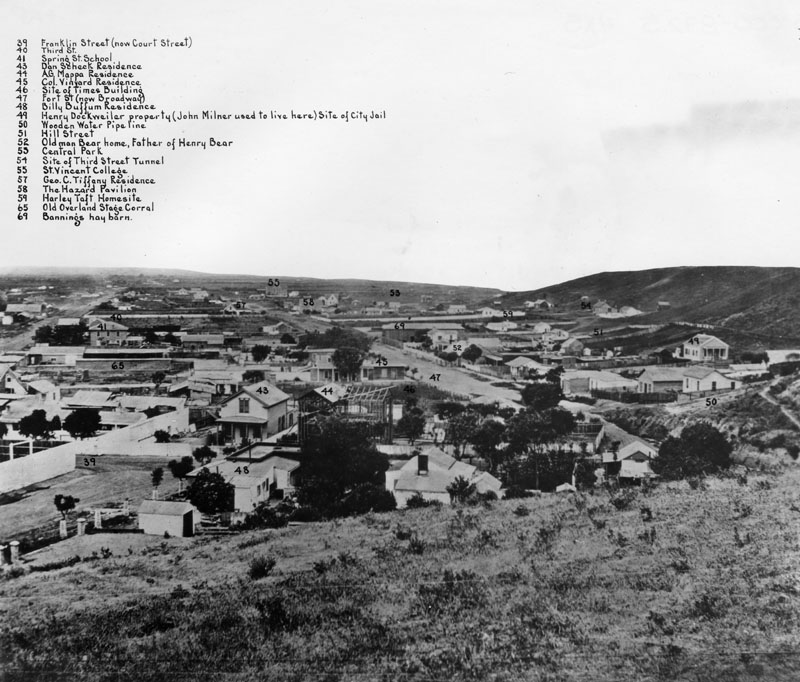

Labeled photo, 1869

This photo is from one end of Bunker Hill which sweeps around to the right. It mentions the Times building and the "old" Overland Stage Corral. The Civil War interrupted the flow of traffic. This was several years after that conflict. Notice that the 3rd Street dig for the tunnel had already started. 

---

So, as grounding or control, here is a modern view of the Bunker Hill area and its surroundings from Kenneth Hahn State Park (Times article). 


May human curators reign for a long while. Thank you, Power and Water Associates. 

Remarks: Modified: 12/23/2025

12/23/2025 -- More on the Butterfield stage as representing the U.S. government's concern for handling Overland Mail. There has been lots of research about the trail from St. Louis MO to San Francisco CA. 

Sunday, August 20, 2023

Reworks and recaps

TL;DR -- During our thirteen years of working, we have had a few readjustments. We are at that time, again, and will be organizing the posts and their information content. At the same time, we are now into American History fully having been given a shot in the arm by the COVID constraints. At the core and toward the periphery, and everywhere else, we will see technology's influence growing, regulary. Probably, too, that will be more steady; after the pop of this latest bubble related to AIn't. 

---

This post collects together stories that are American at the core.  We will add to this for a while. Then, each of these deserves some further study and comment. 
  • Royal connections --  This comes from the Nutfield Genealogy blog that is about as old as this Thomas Gardner Society, Inc. one. We have been working on applications for D.A.R. for a while which has lead to many stories of historical interest. From this work, we continued exploring our theme "the long reach of New England" in many directions which seems to be endless in scope. This post is about a Spanish Lady (with uncountable titles, almost) who applied for D.A.R. membership through a Scottish connection. 
  • Salton Sea -- This huge affair (see article at Wikipedia) in southern CA is well known by visitors and locals. Is it naturally there? This is an answer that was found on Quora with respect to the subject.  

Our first post was on the 25th of September of 2010. We had started to study the family lineage the prior summer (2009). As the winter was amongst us, we started the Wikipedia page, Thomas Gardner (Planter), on the 10th of January of 2010. BTW, one can use "View history" to see the edits through time in detail with regard to the change and the person doing the change. This page needs to be rewritten (see the post, In summary) as does many of the blog posts. Before the blog, we had started the Thomas Gardner Society, Inc. website (summer of 2010). Our first issue of Gardner's Beacon was in the spring of 2011. Our first redo was in 2012 (movement from Microsoft's cloud). We will have more recaps on all subjects as we go along. 

As we research Sherborne records and modify the story, we will also identify places where we cannot tell the story without some speculative modes. These will be clear. We will watch to see how others might conjecture. The thing with the internet and the process used by most publishers to verify information, we expect that those things published will be in good order. However, on the other hand, anyone with a creative bent is free to write to their heart's content. The future will be fun, even with technology muddying up the water. 

Remarks: Modified: 08/20/2023

08/20/2023 --

Tuesday, October 11, 2016

Privileged or not

The WSJ, recently, had a review of an exhibit at the Brooklyn Museum; the article was titled "Polemical History Lesson." Copley and Gardiner were mentioned.
    John Singleton Copley, born poor but risen high on the strength of prodigious talent, is caught in the net of “Pan-American Privilege” in the next section. His portrait, c. 1772, of New England monarchist Abigail Pickman Gardiner, dressed in “the height of London fashion,” is one of three depictions of “privileged Americans” leading off the display devoted to the Colonial era.
I have run across several who sat for Copley in my work. Abigail was the wife of Dr. Silvester. He was the namesake of Henry D. Gardiner. Henry dropped Silvester from his name due to Silvester's loyalist bent. We ought to show the several sides to any of these stories about all things Gardner.

Let's get the fuller picture.

Silvester and Henry are descendants of George of Rhode Island who was mentioned in both of Dr. Frank's books. This is what their book says about Abigail.

About Abigail
Their book: The Gardiners of Narragansett

This summer we started to re-look at possible relations between the various Gardner families in conjunction with efforts being under taken by David T. Gardner, a descendant of a Philadelphia-based Gardner family.  

Remarks: Modified: 10/11/2016

10/11/2016 -- Henry and Weld Gardner of Thomas of Salem were loyalists.

Tuesday, April 24, 2018

NEHGS as mentor

I have been reviewing the Spring 2018 issue of NEHGS' American Ancestor and was given a much needed shot in the arm. The topic deals with the upcoming celebrations of the 400th of Mayflower event which are centered around 2020. Frankly, the scope was quite good, and we can look forward to more of this over the next couple of years and beyond.

Can't wait for all of the settlements to have their party: Timeline of settlements (from Weymouth (1622) to Worcester (1673). And, after. Of course, the list is incomplete (Wikipedia requires continual editorial help).

So, why a shot in the arm? Well, I'm in my 10th year of this work which I have done independently, but I already knew research, mathematics, and computing (which gives the particular bent of my posts). Of course, I started with ancestry[.]com but was off of it soon due to a remark by a D.A.R. registrar. Never looked back. Rather than research other options, I started my own format (works for me) and have millions of items to organize. As I have worked applications (a good exercise and test) to lineage groups (including GSMD), I got the chance to hone the material. As well, I did Dr. Frank's line which I have in ahnentafel (sourced) form (his two paternal grandparents - BB Gardner and LF Wilson).

Along that line, I just looked at a genealogy chart handwritten by Dr. Frank in 1907 (thereabouts). His father's line agrees with what I documented. However, I have more. I noticed that some Mayflower people are now mentioning John Billington (see NEHGS, above). I get to bring up Nathaniel Eaton (friend of John Harvard and first head of his school). And, I have a lot of material including a paper written by a member of The Eaton Families Association. The next TGA (print of Vol III and Vol IV) will include an article on this.

Essentially, Dr. Frank did not expand this tree, publicly. I can see why given what I have read out of Harvard. But, the whole story bears significance of some turmoils now. Just as the 200th of the western expansion pre-dated the major conflict twixt the north and the south, the 400th had lots to tell us about the U.S. and what it might be about. But, just in himself, Nathaniel is interesting (holder of several degrees, including M.D. and Ph.D); his Catholic leanings may have played a large part in his treatment, especially that which might be termed propaganda.

I have done the genealogy of enough now to have covered New England and Virginia and its environs. That leads to things that we ought to be doing. We need an effort to publish the first five generations from Thomas and Margaret. I finally got a chance to look at the Silver Books. Too, we need to go back and re-look. David T. Gardner, from a Pennyslvania Gardner family, has looked at how he might relate to Thomas. See King's Slayer Court. This was the first part that was published in TGA Vol. III. This and the next part will be in the print version (before summer 2018). BTW, mentioning propaganda, David has found some interesting Tudor material (interpretation will always an issue - like the ad, what's in your wallet? - how do you see this is not something to leave totally to experts). Thomas is almost a tabla rasa from what I have seen.

Yet, there is a lot that ought to be collected and organized. That is one task; as well, weighing in with a proper view ought to be more easily done when is little negative influence (such as, Endicott hanging Mary - no last name is needed).

So, we can watch the NEGHS over the next couple of years and learn a whole lot.

Too, we can look at the particulars that Thomas and Margaret bring to bear. Has that sort of thing not waited long enough for some attention?

Remarks: Modified: 01/10/2022

12/30/2018 -- The 400ths will be one theme next year. 

01/10/2022 -- Changed the NEHGS image which disappeared. This year, it's Weymouth's turn. 

Wednesday, June 9, 2021

State Of Missouri, 1821

TL;DR -- While researching we saw a pamphlet from the State of Missouri with respect to their history and to availability of records. The history included several maps at different times which show the carving up of Missouri Territory into counties. By the time that Missouri became a State in 1821 there were only a few counties. Others were defined over several decades. St. Louis hosted a World's Fair in 1904 which was the theme for a Judy Garland movie. 

--

This is a brief post with a few maps which are to show just how quickly things were changing out in the west where we can use St. Louis for a focus for a while. Before jumping ahead, here are a few pointers to related information that pertains to what the first map (below) shows.  

  • Northwest Territory -- this was being defined in the early stages of the U.S. as things were being settled. By 1805, Ohio, Kentucky and Tennessee had been established. 
  • New Madrid -- indicates that New Spain was there. Too, the Louisiana Purchase covered a lot of territory; however, notice that the surrounding pieces of New Spain and unclaimed are as large. 
  • Trapper, trader, rancher -- we have mentioned several of the trappers who were early out west. William Bent is an example of a family that had already moved. His father, Silas, was involved with the continual surveying necessary during the period shown below by maps by years. 

So, we start with an overview. There were three areas still to be handled in the northwest, name Michigan, Indiana, and Mississippi. These, btw, are east of the Mississippi that sets the eastern border of the Louisiana Territory.  


The next maps are local to the central/right region dealing with the area around St. Louis. We start with a 1804 look with names from New France and New Spain. The culture there of St. Louis is as aged as is Essex County of MA, for example. All of these maps come from a little book titled Missouri's Public Domain: United States Land Sales 1818-1922. We were thumbing through a copy of this today and are happy to find it online. In several other publications, we have seen a history of the area from several sides, such as Missouri or Arkansas or other. Some of these were quite detailed. This is quite direct and oriented toward sales. 

By 1812, what Louisiana brought was under siege by newcomers. By the next year, Arkansas was under consideration as it was being carved out of New Madrid. In 1799, Boone, himself, was in the St Charles area. He was involved in the local area. There is a tale that he went up the Missouri River, as far as Yellowstone which is remarkable for someone in their 70s.

                         1804                    1812                            1813                     
 
1816
In all of those maps (1804 thru 1813), one can see the Missouri River cutting across the top. In the middle two images, it is the top boundary of the St. Louis County which extends from the Mississippi River on the east to the left border. What is there? The next map from 1816 brings in the west and the north. A Howard County picks up the Missouri and extends the northern border above which will be Iowa. 

Then, in 1821, we see the initial look of the State of Missouri. Howard is cut down in size quite severely. Boone gets a county named for him in middle of the state along the Missouri River. 

Anticipating the movement further west, the activities of the Trails which flowed through the Kansas City area will be in Ray County. That is, as we will see, lots of traffic came down the Ohio to the Mississippi and then went north to St. Louis and west on the Missouri. It was at Kansas City where the focus changed from water to the toils of laboring across the landscape. 

All along these ways, we had families seeing something they liked and staying. Or their decision was the result of any number of issues that could have arrived. The net effect is our Frontier Century

1821

With a nod to culture, St. Louis hosted a World's Fair in 1904. It's theme was the Louisiana Purchase. We have a lot more to look at with respect to the century and what it entailed. 

In 1944, there was a movie titled Meet me in St. Louis. We can look further for New England references, but one of the stars has plenty. Namely, Judy Garland (Famous Kin). 

Remarks: Modified: 03/17/2025

06/17/2021 -- Add the TL;DR. 

03/17/2025 -- Independence and Kansas City. Stopovers for people going several ways. 

Monday, September 12, 2022

Tours, of the real

TL;DR -- We are of the west and have been, for the most part. Though, the long arm of New England is always there. A couple of years ago, we looked inward after considering all of the naval modes that came about in the 400 years of interest. Or, if we were doing land studies, the wilderness was only a few hundred miles away. Lewis & Clark, thanks to Jefferson, opened a huge vista. There had always been those who traipsed the regions, early on with the Native Americans. Then, we had this rolling wave, technologically abetted, that ran over the landscape, carving it into pieces. Or trying to. Our upcoming anniversaries will allow us to relook (again) and to, perhaps, make ourselves and things better. 

--

This year, we ran across a photo of a cemetery. Looked to be New England. Or, any of the northern wooded  areas that abound. It turned out to be in the area of The Catholic Osage Mission which was established in 1830s to serve Native Americans who had been forced out west by President Jackson. This was the early group. Our post looked at the Mission and those involved. Of note was that this was on the KS side of the area, not the MO side (referring to a conflict that ensued three decades later). 

Today, their FB page pointed to a site (Woodbury Historical Tours - link only, no endorsement) which had an image that showed part of the Santa Fe Trail. On visiting the site, we saw an image which shows details of a very interesting trek that is planned for next month. The trek (technically assisted) goes from Kansas City, MO to Sante Fe, NM. In the image, one sees two major rivers. One is the Arkansas; the other is the Cimarron. We spent some time the past couple of years, looking at rivers as a boon and a bane

It is great to see this type of offering which we hope will become more prevalent in the future. The U.S. start is coming up (250th). The Frontier Century started a couple hundred years ago. Before then, we had the fur trade drawing people out west. One example is William S. Bent (Trapper, trader, rancher). Pertinent to this graphic (map) is Jedediah Strong Smith who met his demise somewhere in the area depicted by the lower part. 

JSS has a modern following that was organized in the Berkeley, CA area. David Woodbury (Historians discuss the Civil War) lives and works in the Stanford area. He is not leading this tour but has been active in publishing which caught our interest with respect to different attempts over the years. Say, TMM (Dr. Frank) which published some of the western visitors, like Col. T.W. Higginson or Judge F.M. Thompson. Or, even someone of the Sanborn family. 

One of our regular modes is to find New England connections in general followed by determining if there are further links to the specifics of Massachusetts, Essex County or Cape Ann. Woodbury was one of the initial investors and "comoverers" (quoting H.H. Crapo). Of course, a Woodbury is in Ann's lineage through Benjamin Brown Gardner, spouse of Lucy Foster Wilson Gardner which is part of the additional interest. Families moved far and wide over the years.   

Aside: We have done extensive research in the large middle of the country and have barely touched the whole of it. At the same time, given Essex County's shoreline, we have lots and lots of work to do with regard to the navalphiles. Then, there are the other cultures who were here, the various News (Spain, France, Sweden, and others). We like the middle given our landlubber modes. 

There were many trails. Later, before the railroads came in, we had attempts at systems for moving people and goods by coach. One of these was the Butterfield effort which leveraged off some work done by an Ipswicher of the Giddings family. But, we are getting ahead of ourselves. As we really need to fill in lots of holes with regard to those early families that came after Lewis & Clark left and around the time that Boone came in. 

Back to David Woodbury, he wrote a diary starting with the March 2020 inception of the lockdown. Some of his comments are funny, such as the references to the totally unrealistic views of some Zuckerberg - types (did I get that right?). And, these ones (immature lot) gave us the stupid web out of silly valley. For a while, Woodbury worked with Savas Beatie who seems to be out of Iowa. We ran into that state when researching what happened to the North American Review

We are regrouping and, so, expect more of these recaps that are motivated by what others are doing to help get the message out about American, its past and why it induces a dream state so readily. 

Remarks: Modified: 09/22/2022

09/22/2022 --  Added "no endorsement" with respect to the tours. We are researching the relationships. 

Tuesday, September 11, 2012

Gardner's Beacon, Vol. II, No. 4

One goal of the Thomas Gardner Society will be to collect, and hopefully organize, material that references, even if indirectly, the lives and time of Thomas and Margaret and to construct a coherent view for future generations. However sketchy this material might be in the beginning, future research can help flesh out the story. The works of Dr. Frank A. Gardner, and prior work, by others, establish the basis. Gardner's Beacon, and its corresponding blog, has tasks related to supporting this theme. Another approach would be support for scholarly papers.

---

We have our first guest article written by John Goff who is an architect and who has been very active in preservation efforts across New England, principally Salem. He is a Thomas descendant. John provides technical commentary on the Gardner-Pingree house (see earlier post) whose construction represents the amount of wealth that had been attained by the Gardners.

Image from Conant book
---

As we look back, there can be obvious differences of opinion about what information means, especially, if it's scanty. Scholarship would suggest to look at all sides of the issue. There are several examples.

The house built on Cape Ann, called the Governor's Faire House (GFH) by Rev.Higginson, is a good example. Earlier (Thomas' (note comparison to a house in the Pilgrim area) or Margaret's house), we used an image provided in the 1887 book by the Conant family (pg 104). The house had been moved by Endicott from Cape Ann to Salem. That means that many would have seen it and could describe what they saw to an artist.

Photo by John Goff
Salem Preservation, Inc. 
In 1930, Dow, et al, built the Salem Pioneer Village so that people could see how things were 300 years before. We have the 400th look back coming up. The image on the right (photo by John Goff, Salem Preservation, Inc.) shows how Dow conceived the building. It does not match up with what the Conant book said. Of course, any information about dimensions may have been hard to find. Yet, one could imagine that the ship(s) may have carried material for a house, as depicted by Conant. There would not have been enough time, even with tools, for even the house of Dow to be built, given the small size of the crew plus the fact that they had to get themselves settled, fed, and a whole lot of other important things.

What did Dow go on to make his re-creation? John Goff mentions that the GFH towers over the other houses which are mostly either diminutive English timber frame cottages or English wigwams built with bent-sapling frames.

---

See Vol. II, No. 4 of Gardner's Beacon which considers some of the houses that have been associated with the Gardner family over the years.This issue on houses was interesting; our coverage of the topic ought not be thought of as complete, by any means.
References: Conant -- History and genealogy ..., Dow - Every Day Life ..., Fischer - Albion's Seed ..., Stone & Fickett - Every Day Life ...

Remarks:

03/09/2019 -- Added in image to build an index at our portal to truth.

01/25/2013 -- By the way, we're going to document this more thoroughly on Wikipedia - Great House (Cape Ann). We have John Goff's expertise available to assist us. This house was the first of its kind in New England.
10/27/2012 -- See Great House (Cape Ann) on Wikipedia. As Higginson said, it was two-storied with a high-pitched roof. The image from Conant's book, and from the letter by C.M. Endicott, shows three-stories. The house underwent major alterations in 1792 which was before the sketches were done. Unfortunately, no sketch exists from earlier times.

10/24/2012 -- John Goff (Salem's Witch House ..., pg 24) writes: After his arrival downtown in 1628, Endicott ruled that the old Thomas Gardner "Governor's House" from Cape Ann (built about 1623) be dismantled, moved by sea from Cape Ann to Naumkeag and be re-erected in earliest Salem to serve as a new Governor's House here. It stood north of the old shawmut on what is now Washington Street.

09/12/2012 -- It was said that we're not done with houses. Fischer notes, in Albion's Seed, that the lean-to was found in Kent, England in the 17th century, though not many have survived. Despite its usefulness in New England, evidently the 'seed' for this type of house came over with those whose background was from the Kent area.

09/11/2012 -- The Stone & Fickett book has the younger student in mind and provides classroom exercise. Ought something similar be done for later students?

Modified: 03/09/2019

Thursday, August 5, 2021

Michigan, 200 years ago

TL; DR -- Dr. Frank's TMM had a regular column on Massachusetts Pioneers to Michigan which we knew about but did not probe deeper. Now, we get a chance as it took longer to get areas east of the Mississippi settled than it did Missouri and Arkansas. So, we will look at both sides of the big river for a bit including a look down south with Louisiana and Texas. Per usual, we relate things to the event of 250 ago after which the developments under study occurred. And, to lessons not learned yet; the context for these change with the times; will we ever learn? 

--

In The Massachusetts Magazine (1908 to 1918), C.A. Flagg, of the Library of Congress and friend of Dr. Frank, wrote of the Massachusetts pioneers to Michigan. We did not really pay attention to this until now. The last post (Practice for carving) mentioned that there were two situations, as we might think, namely east and west of the Mississippi River. Our focus has been on the latter. Now, we have a chance to step back and look at the former. 

One motivator is the event called the Toledo War which was a verbal conflict between different parties for a strip of land that bordered Ohio and Michigan. Michigan State University provides several maps in their paper part of which are in this composite. 


Another motivator is running across a family one of whose ancestors bought land in the Michigan Strip, according to the records of  the Bureau of Land Management which records we used for studying Missouri. As the west was carved, there was paperwork to be done. Too, surveying was a big time business. One early practitioner was New Englander Silas Bent. His son was at several meetings with the American Indians with respect to peace. So, that is a topic to look into, as well.

All of this relates to the long reach of New England, across the interior and the seas. As an aside, in terms of families, the non-logical genealogists have dissed all sorts of families. We will get to that, as it is John's area. Not genealogy. Rather, modeling, problem solving, philosophy of mathematics and science and the related subjects including deep knowledge of computing (all aspects) and that wannabe called AI which has raised so much mania/angst and glee/euphoria through fairy dusting that comes from too much SciFi, fantasy, and sheer unrestrained imagination. 

That is one of the major TGS subjects for research. One might add mental health with a nod to the pair who fled the UK for the US last year. 

In any case, we will pull out the Flagg articles so that they can be used. One family was in the same spot but was, over the years, in Louisiana (lazy mode, we suppose) and then two counties in Iowa. Same goes for the Strip. And, we have not looked yet at the many other States that were populated after the colonies split from the Crown. 

For those being dissed, many died young, like the case for the Mayflower where a stepmother came along and muddied the waters. Then, the father died young, too, leaving his infant (whose mother had died early, too) with the woman who ran off, but her uncles saved the day. Then, a modern mind touting its genealogical expertise (a scientist, to boot) could not rectify the facts. This is too much of a general problem, folks. John has now 10 years experience of bouncing against this mind set. Too, those who look are talking the general problems of computing and knowledge, especially that at the higher relams where people really ought to know better. 

BTW, note that Anderson of NEHGS had everyone thinking of three wives for Thomas. Okay? Look at WikiTree. We now have it back to two (Margaret and Demaris) with some work being done to fill that picture in further. 

Oh yes, Missouri was settled in 1821, somewhat, though it took a while for the counties to shuffle to their modern definition. The Strip was still being contested (conflicted) until 1835. That would have been about the time that Texas was rumbling with respect to north and south, as in, European cultures over here with their pissing contests. We will be stepping down there, to boot. Got to love Texas, people. 

Michener, in his research, noted that the Mexican War was really a training ground for the Civil War. Dr. Frank noted that the Crown trained the U.S.ers in the conflicts with New France and its American Indian allies (so called French-Indian affairs) so that they could rebel. And, we are now approaching the 250th of that. Lucky us. We see that New England's experiences will be needed to keep things straight due to so many opinions based upon things of little to none provenance. We have to correct that over time in order to frame a better story for future generations. 

Remarks: Modified: 12/16/2022

12/16/2022 -- Finally got around to looking at the first steps west which were driven by Ipswich MA. Also, Rutland VT was involved. See Perspective, a necessity


Thursday, December 2, 2021

U. S. Interior

TL; DR -- Before, we talked of the 100th, 200th, 250th, 300th, and 400th coming forward from Cape Ann. Where the 250th deals with the U. S. start. The 400th involved New England and more. Now, we can talk 400 years ago, 200 years ago, and now. 400? The forebears crossed the sea. 200? The waves of immigrants crossed the prairie and other areas of the U. S. interior. Now? We are all sailing the seas of the cyber and virtual and more due to the computationally-framed new world. 

--

In the latest issue of Gardner's Beacon, which was Vol. XI, No. 1, we mentioned one of our continuing subjects: U. S. Interior. In part, the subject of the U. S. interiors deals with history, however we add in the family aspect with the same intent as groups focused upon historical and genealogical topics (say, the NEHGS). We have called the period of over hundred years in which the interior expanded to be the Frontier Century

While browsing today, we ran across a map that looked interesting which is given below. However, let's take a moment for reflection. The map was in a collection of other images related to why the U. S. has been successful, in the world, which is a debatable subject. There was no attribution, so we used the facilities of Google's image search to find the source for the map. It showed several similar maps, however PInterest had the map and pointed to where it got the map. So, that was nice to see. 

The site is run for teachers. Here is the map which provides a timeline for acquisition as well as some indication of the geography. We have had several posts on this subject which are list below (such as, All that Louisiana brought, which is first on the list).  


The map also was used at a Quiz site. Doing this exercise made us aware of a Wikipedia page that looks at the "Territorial evolution of the United States" and provides an animated map. This reminds us of the Virginia map showing its extent over the first few decades.  

List of posts dealing with the western expansion (as we call it). Part of the discussion and work will be taken by concerns for our relationships with the American Indian
  • All that Louisiana brought (Nov 2020) -- The brown area picked up by Jefferson which included St. Louis. 
  • Sam Dunn (Nov 2021) -- A look at the interior by a Londoner in 1794. 
  • State of Missouri (Jun 2021) -- On the right edge of the brown area which was the HQ, so to speak, of those who were surveying, who were early arrivers (fur trading), or who were just passing through. 
  • Michigan, 200 years ago (Aug 2021) -- The light green area on the right includes the colonies and areas that are close. However, things, such as borders, were still being settled there in the early 1800s giving a chance to practice carving the land in a big-time way. 
  • Rendezvous (Apr 2021) -- The dark green area to the left includes the mountainous regions of the northwest (the real one, not the area around Ohio). 
  • New Spain (Feb 2021) -- Covered most of the region west of the Mississippi. This map includes the major rivers which helped carve the land. Coronado was in the middle of the brown region in the 1540s. 
  • Pre-Civil War, San Antonio TX to San Diego CA (Mar 2021) -- Cutting across the lower part of the U. S. in the early days. Again, for the hearty. 
  • Carving the land (Jul 2021) -- As mentioned, St. Louis was an early sight where the surveyors got started on the great middle. The post includes a color-coded map with discussion. 
  • Department of Interior in MO (Jun 2021) -- One of the earliest departments of the new government. Following the Boone family into MO might be of interest for several reasons. 
  • 3 Trails (Sep 2019) -- St. Louis might have been where the paperwork was shuffled, but those heading west converged on the area around Gardner Junction KS which is west of Independence MO for some time. This is in the middle brown section. 
  • Trails West (Mar 2016) -- The Gold Rush (left coast) was later. While it saw a substantial bit of travel by water (around the Cape or split with a ground jaunt across Panama), there were many who went by the trails. The Bostonian went around and sailed from Jul 1849 to Jan 1850. After a jaunt to New Zealand, it returned and shipwrecked along the OR coast. 
  • Paper Trails (Jun 2021) -- One can follow the Post Offices through time (see maps by year). Looking at the treads related to the points, one can get a sense of the eventual railroads  as well as the modern highway system. 
  • St. Louis MO to San Francisco CA (Jun 2021) -- About eight rough days for the hearty traveler. Post also shows the progress of the establishment of the railroad in three maps. 
  • Jedediah Strong Smith (Jul 2018) -- He mapped out the CA Interstate system on foot and horseback. 
  • Trapper, Trader, Rancher (May 2021) -- The Bent family out of New England eventually got to St. Louis. The father was a surveyor and agent for the government. The son was in MO, KS, CO, OK, and TX (using modern state labels throughout to save the fingers). 
  • Rivers and more (Feb 2021) -- The Mississippi and its feeders cover a lot of the brown and light green areas. In fact, water from eastern PA (and NY) go down to the middle of the country. In the dark green of the upper left, waters come down to the Missouri river. 
  • Oregon or bust (Sep 2021) -- Gardiner OR was founded where a ship of New England ownership wrecked. People went out by the wagon trains. Or, they came in from the Pacific after a long voyage. 
  • New France (Feb 2021) -- The area covered was in the upper U. S. as well as in Canada. 
  • Scholars, in general (Aug 2020) -- Papers and maps on the divides that run north to south along the western edge. 
In conclusion, New England influence by family or other parties is our interest. We can see a good reminder with respect to the founding of Lawrence, KS and the University of Kansas
    To set the stage, let's do a quote. This is from Chapter 1 in which Cordley quotes from Whittier's poem, "Song of the Kansas Emigrant:"
      We cross the prairie as of old
      The fathers crossed the sea,
      To make the West, as they the East,
      The homestead of the free.
So, as the early ones "crossed the sea" 400 years ago, we saw the later ones crossing the prairie, the river, the mountains, and the valleys 200 years ago. 

Nowadays? Flyover country or by car (1300 miles from San Antonio TX to San Diego CA, by Interstate, 22 hours). 

BTW, one other focus is technology, especially computationally framed reality. So, now we are going to be sailing the seas of the cyber and virtual? 

Remarks: Modified: 12/03/2021

12/02/2021 --