Showing posts sorted by date for query lewis clark. Sort by relevance Show all posts

Saturday, December 20, 2025

Overland mail

TL;DR -- Bunker Hill West was on our sights early as we looked at the progress of New England's influence into the west coast. We noted that a coach company had facilities there and that the journey for some arriving had started in St. Louis and was going up to San Francisco. That route was covered in both directions. There is a group that has been documenting the company and its involvement. One of the investors was of a Gardner family. We went to look for information about him which we will report. This post is an introduction to Overland Mail as an initiative of the U.S. government starting early. 

--- 

As earlier posts mentioned, we used the isolation of the COVID times to pay more attention to the interior of the country. We got started with the naval activities, such as coastal attempts at colonies, fishing in the waters over here every year with the expectation of going back with some dried fish, and more. Too, the naval history of New England is rich prior to the Revolution which is facing its 250th lookback and after with the proliferation of companies related to shipping. 

In those earlier times, western movement didn't go much beyond New York. Though, early on, locations like Ipswich MA sponsored migration as best they could. Except, there were the wanderers even prior to the Revolution. Northern movement down to the area of Arkansas was going on about the same time that northern New England was getting its start. Even the west saw Europeans coming into the area even before Lewis & Clark's venture. 

Once the U.S. was born, it took a generation for activity in the west to reach a level of interest with St. Louis MO as a focus area. Much of the western traffic moved through that area, partly due its proximity to where the Ohio river joined up with the Mississippi. But, there was naval access to the west coast, as well before the Gold Rush of California. Some of this was due to Hawaii being a stopover point for sailing the Pacific. We intend to look further into that theme.

But, with land movement, we can map out areas and time frames. Jedediah Strong Smith was a focus due to his going out west through St. Louis (1820s when MO became a State) and then his extensive journeying in the west, including a stint in the LA area when it was still under Spanish rule. 

It was about then that we bcause aware of the St. Louis to San Francisco (LA_SF) coach route. Our focus was mostly about LA due to it being a stopover on the trail going to  San Francisco. The image shows DTLA in 1900 which a view toward what became known as Bunker Hill West which was named by a displaced New Englander. 

1900 scene, of Bunker Hill West
where Overland Trail coaches
came in, for relief of passengers
and sources (horses)

Recently, we noticed that there have been more publications on a website on the subject with information related to the LA_SF jaunt. More information has also been provided about the TX to SF part of the trip. Now, the eastern portion has better coverage is getting attention: Missouri, Arkansas, and Oklahoma (with respect to the Overland Mail). For instance, AR is mountainous. One thing passenger were requied to do was get out and walk with the coach as it was slowly moved through the hilly areas. 

States in the area. Kansas had a lot of east west traffic. One research provided lots of information and commentary on that state's support for Overland Mail  (as it is seen in KS). That is now the name of this activity which denotes the main purpose plus the involvement with the U.S. government. St. Louis had heavy activity as the country was divided and sold throughout the west. 

Other states involved were TX, NM and AZ in the south. We will be looking at other views on Overland Mail as the Pony Express came to be for that specific purpose and ran across the northern states.  

People? The group devoted to the history and preservation of the Overland Mail route (that is associated with Butterfield - who never put his name on the venture) (The Historic Butterfield Overland Trail in Arizona) has done remarkable research. We are fortunate in that area. One of their latest ventures is to identify the employees who saw to it that the coach made it from MO to northern CA. The infrastructure was astoundingly complicated. 

In terms of comparison, we have a post that shows how the 21 days (3 weeks) of one way of this journey compared to other situation. For instance, the same amount of time was taken for a portion of the trip by wagon train from Independence MO (across KS and NM) to Sante Fe NM. Fort Lanerd KS is on the trail and 3 weeks away from the start. 

We made contact with the Butterfield group. There was a query. One of the investors was named James V P Gardner. Who was he? On a quick look, we identified one resource from the late 1800s that suggested that he was from a New England family. James V P Gardner (son of Daniel (6) - James Van der Poel Gardner -- as descendant of George of Rhode Island) would be a cousin of the Gardiner for whom the city in Maine was named. Too, he would have been related to the Gardiner who owned the ship that wrecked off the coast of Oregon in 1850. 

We will post what we know about James V P Gardner as a preliminary report from which we will build something adequate to serve as a truthful basis for information about him. 

The information from TGS, Inc. efforts is being provided now with the caveat that we need to look further into sound/solid provenance of the sources that are used. Bringing in another factor? Technology of late has seen itself contributing more to disinformation than to information. The theme is on our watchlist and is (will be) an actual focus for the TGS, Inc. at all levels. 

John likes to use this example: From the top, we have folks of huge cachet for whom History has lots ot say; getting modern, we have the top-level offices of the G-Suite (military) and the C-Suite (the industrial/commercial part of the activity); then the huge middle management realm; down to the workers and users of whatever the economy is about in terms of keeping the modern life viable. At each level, there is no one truth that can be said to be accurate from top to bottom. Or from bottom to top. 

The computer has both helped and hindered attempts at briding the gaps. Of late, things have been more problematic than necessary for various reasons. John jokes about buckets'o'bits and their misleading clouds, though many are working to make things more stable and sustainable. We all can help. 

So, with respect to our research and reports, we will keep the "shining light on the hill" (Winthrop) in mind. Too, our site will be "bespoke" for many reasons with the goal of providing a "portal to truth" which notion comes from the mid-2010s as we incorporated in order to organize future efforts.  

About sources? We have them. For Gardner Beacon issues over the fifteen volumes, we started with a Bibliography and Source page. However, we started to provide links from the issues to posts from this blog. However, we are looking into a better organization of our several blogs for proper curation of sources. 

Note 1: The information about J V P Gardner and his life looks good, even though we need to check the provenance of the pedigree. There are many extant documents that will support this work. This Note will be updated when the post about J VP Gardner is published. 

Note 2: The following photo is more apropos being from the correct period. The Bella Union Hotel had roots back to the 1830s. The Wikipedia page has some of the history. 
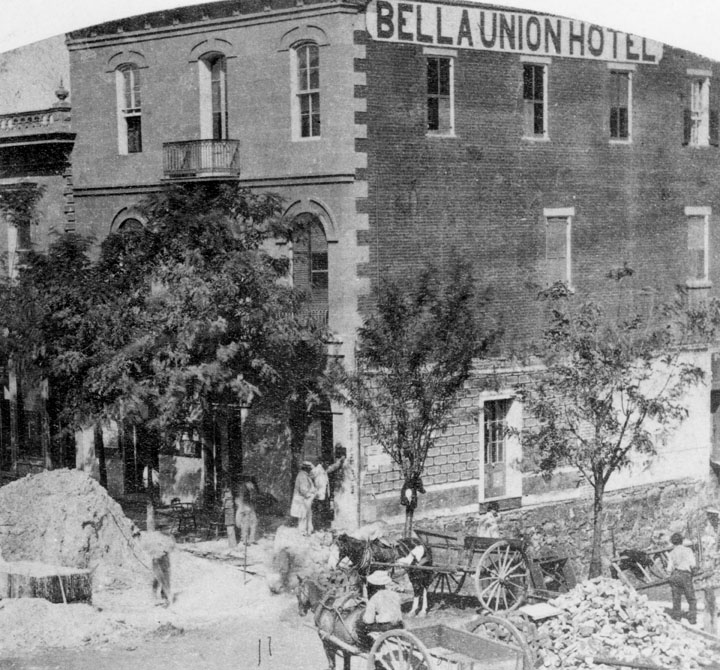
This is east of Temple and Main Streets. Temple runs up into Bunker Hill West. 

Remarks: Modified: 12/23/2025

12/23/2025 --


Thursday, October 2, 2025

States and watersheds

TL;DR -- We have lots of themes to research. Rivers will be a constant. Today, we look at watersheds, again. Too, we consider a map showing the findings of Powell as he explored the west. American would not be the same without its rivers. 

--

We saw a map today that got our interest. Perhaps, at some point, we'll link to all of our posts that present a map as we continue our look at the history of the U.S. and its first colony of New England (mainly north) being respectful of the Native American culture as well as the incursions of New Spaiin and New France both of which left placenames in their language. 

Rivers are the focus today. We have many posts in on rivers and some on watersheds. And, we mentioned the Arkansas River in an earlier post today. Before making a few more remarks, here is a map related to the discussion. 

The United Watershed States of America

On the page providing this map, one can click on the map and get an enlarged view. The Arkansas River goes from Colorado, through Kansas, Oklahoma, and Arkansas before it flows into the Mississippi. It was this location where explorers out of New France (north of New York) saw artifacts from New Spain. 

It's worth mentioning that New Spain explorers were in the northern Kansas area in the middle of the 1500s. This trek was to find the cities of gold. We have a town El Dorado not far from the route taken by the Spaniards. 

Back to the map, it shows the route taken by John Wesley Powell in 1869. This was post-Civil War when the traffic to the west increased. 

Another reminder, Jedediah Strong Smith was in some of these areas in the 1820s. Having gone from New England to St. Louis, he went west and ventured into the moutains near Gardner River. He went south into the desert of Nevada and crossed the Mohave in the summer (first European to do so) ending up in LA where he was the "guest" of the Spanish Governor. Once released, he went north and east. He met his demise in Kansas at a site along the Cimarron River. 

Later, Judge Francis M. Thompson toured the area. Tour, of course, meaning on foot and horseback. Like Jedediah, he got to the left coast. On the way back, he spent time in Montana and helped the State get is legal footing. 

In all of these journeys on the land, we talked of rivers as means for transportation (Lewis & Clark) or barriers to progress. An, example might be the Lawrence, Kansas-bound group that founded the University of Kansas - they had to cross the Wakarusa having come from Massachusetts. That meant, breaking down the wagon, lowering it, getting across, raising it back up to high ground, putting it back together and then continuing. The Wakarusa was fairy tame compared to the wild western rivers that those of the Santa Fe and Oregon Trails coped with. 

We can now consider another aspect of rivers. There are many more aspects, but the watershed aspect is important. An example are the irrigation canals of the west, such as those in Utah and Idaho which supported agriculture. Of course, we learned to tame rivers for milling and transportation of goods. Our post on the Gardner mill of Salem, MA is an example of a multi-purpose mill. The canal laid out by George Washington and his crew along the Potamac is another early example. General George Washington was at the Siege of Boston and became the first President. Even Betsy made it up to see him. 

Remarks: Modified: 10/02/2025

10/02/2025 - 

Saturday, August 16, 2025

American rivers, flow

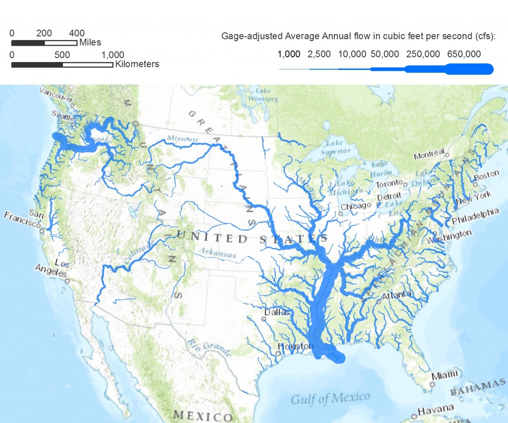
TL;DR -- We saw a graphic while browsing that was not attributed. So, we went looking and found something similar. It shows the comparative flow of the major rivers. The Ohio River stands out as does the Mississippi River which it feeds. Rivers in the southwest are drier by nature. But. they have lots of people drawing off of them. 

--

Rivers are a favorite subject. We enjoy them many ways. Some are famous. Others seem to have disappeared. An example is the Arkansas River that comes out of the Rockies of CO and crosses several US States before joining the Mississippi in AR. Along the way though, if one searches for the river it seems to have disappeared. But, the flow went underground and reemerges sufficiently to support barge traffic from Tulsa, OK to New Orleans, LA. 

On the other hand, the mighty Colorado River comes out of another part of the Rockies in CO and heads down to the Gulf of California. But, along the way, it is dammed (for Lakes) and tapped for people and crops. By the time it gets to Mexico, it is a small portion of itself. 

Those are two western examples. Looking east, the Mississippi gets a large flow from the Ohio River after it has joined with the Missouri River near St. Louis, MO. Lewis & Clark was on both. They took the Ohio down to the Mississippi, then ventured north to travel up the Missouri River, to its source. In doing so, they also looked at some of the rivers of the northwestern part of the US.

What motivated this post was seeing a graphic and looking to see its source. We show the graphic below. At the same time, we looked at some of our earlier posts as they presented graphics too. Let's list a few of these and then add in a new graphic. Each post has a graphic with respect to US rivers. 

  • Continental divides (Feb 2025) -- we think of the Divide that we cross as we travel east-west in the western part of the U.S. But, there are other divides. 
  • New Missouri (Aug 2022) -- when one compares the upper Mississippi to the Missouri, the question about naming comes up. This was really the Missouri River which contributes more water from a longer route. Whereas the flow from the north is shorter and looks larger. 
  • East meets West (Jun 2022) -- the Gardner River flooded and got our interest. It flows through what is known as Gardiner, MT. The map shows all of the watershed of the continental U.S. 
  • Research notes: Rivers (Feb 2021) -- looks at some western rivers (Yellowstone, Gardner, ...) in an area where water goes either east or west.  
  • Rivers and more (Feb 2021) -- looks at the Mississippi and one link from the west to the east via the Fox River.  
  • How great? (Feb 2023) -- looks at a couple of elevation maps of the U.S. This is to put the below material into perspective.  

We started really looking at rivers during the time of the pandemic. We were doing a lot of research which involved families who came west after the time of the U.S. start. This relates to the 250th anniversary of the birth of the Nation. Then, as we researched, more and more information became pertinent. This work precipitated our use of Frontier century and Lost generation. 

First, let's put up the graphic which shows the comparative flow of watersheds that reach a certain rate of flow. Some of these show up with a light color since the flow is reduced severely as the water makes its way out of the mountains to the shore. 

American rivers
Pacific Institute

In the middle, one sees the long reach of New England with the Ohio coming down to the Mississippi. So, stepping back, one can see the importance of the use of the Ohio in movement to the west. Wagons were brought west, moved north on the Mississippi, and then went up the Missouri. At that point, the wagons went west by land with rivers to cross. That shows rivers in two roles: means of motion; barrier to progress. We looked at the second one in our look at the New England party that left Boston and journeyed to Lawrence KS for two reasons: define a State; start a University. 

Remarks: Modified: 01/03/2026

01/03/2026 - Corrected a typo or two. 


Thursday, June 12, 2025

Lord Fairfax

TL;DR -- Little known facts are around and about upon the landscape of the U.S. Our normal attention is west (west is best; east is least - sort of thing ;>). However, there has been and will be attention to the eastern activities as the western part came about 150 years later where the Revolution became a central theme. This post touches upon the time that Braddock came over. Evidences abound due to preservation efforts. Otherwise, the landscape has been abused (data centers abound, for instance). 

--

We had to mention the 400th (Jamestown, et al) so as to set a stage that will be permanent. We would not have had the 250th without the earlier phases. So, Fairfax? His name is all over northern Virginia as are others of the upper class (kin/cuz, as well). But, the main thread will be dual. For this post, let's use "French, Indian affair" which we have touched upon before. 

While researching people who went out west from the older east side of the country, we had to bring in other cultures, such as New France and New Spain. From each, the U.S.obtained land that had to be incorporated into the Union. Too, there had to be maps that to allow reasonable control of land use (or misuse). We looked at some of this in a post titled Practice for carving about the work that went on for decades, starting in St. Louis. 

Now, in the interior, we usually think about things that happened after Lewis & Clark and the War of 1812. However, there was earlier activity out there by Europeans, for the most part related to involvement as trapper, trader, and rancher. In that regard, prior to what we are now celebrating (the 250th anniversary), there was the conflict that trained colonists for the coming Revolution. 

Namely, we consider the French, Indian affair which seems to have been mostly forgotten. Dr. Frank wrote about this conflict in his series on the Regiments that were at the Boston Siege. But, stepping back, we have had posts on this affair.  A grandpappy kept a diary that was later published: Nathaniel Knapp's diary about his time with the Louisbourgh Expedition. Some who were involved participated in the later Revolution, many times in a leadership role. 

--- 

With the French, Indian affair, we have taken a New England focus since Quebec was the principal establishment of New France. But, the conflict involved all of the colonies. An example is Virginia. 

Today while at a park, we read a historic sign. It mentioned Braddock. But, being in Virginia, there were two other names of note: George Washington; Daniel Boone. We last mentioned the former (Washington) here in this blog in a post on Col. John Glover who was featured in the series by Dr. Frank. But, Washington mapped and surveyed the Potomac River which we have to consider further. This post is a start as we have covered many of the rivers of the west. 

Now, the latter (Boone) has been mentioned many times in posts about the early settlement of the west. Boone, well-known explorer: opened a pass; served in the French, Indian affair and the Revolution; settled areas from the east to western Missouri; ventured out into the west.  

---

Washington was also involved with a conflict between the British and the French. The resentments that led to the Revolution are thought to have resulted with the arrival of Edward Braddock  and the reaction of the colonists to his methods. One of Braddock's early campaigns involved a planned attack on Fort Duquesne, French facility, near the start of the Ohio River. This expedition did not go well which left lasting impressions on both Washington and Boone. Braddock was mortally wounded which meant that he had no say in subsequent matters nor in the trashing of his reputation. 

---

Braddock arrival into Virginia was near Hampton Roads. After some meetings in Virginia, there was preparation for the attack on the Fort. Now, accomplishing this required going over a moutainous region that impeded traffic. Washington was familiar with the area due to his duties with the surveying crews that mapped the Potomac. 

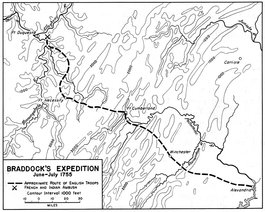
But, let's look at the route that was set up for Braddock's forces by using a couple of images. 

Braddock's route from 
Alexandria, VA to Braddock, PA

Braddock's route from
Cumberland, MD to Braddock, PA

The first images shows the "approximate" route from Alexandria (on the coast) which is on the Potomac to the final destination near Fort Duquesne. It passes through the interior of Northern Virginia and climbs up into the Blue Ridge mountains. This map gives us the elevations. At Cumberland, the elevation is much higher, and we see the route through western Maryland into Pennsylvania. 

---

Braddock's route went through the Keyes' Gap which is over 900-feet high. Formerly, that route from Alexandria to the mountains was called Vestal's Gap. Parts of the trail can be seen in eastern Loudoun County of Virginia. This area is near Dulles Airport outside of Washington, DC. 

The route follows an old Indian trail which is 65 miles in length from Alexandria to the  mountains. 

---

In terms of historic preservation, Loudoun County has provided historical markers with notes in the area. Too, they have a website which is of interest. This is an example of the web/cloud being useful to education at several levels. One example (2019, LoudounNow): 
  • In Our Backyard: Preserve the Vanishing Vestal’s Gap Road - property of Lord Fairfax, originally, almost 400 acres are preserved surrounded now by heavy residential and commercial development including Dulles International (and recently, the heavy foot of data centers trample the countryside). Pieces of the trail still exist (with an interest not unlike those remnants that we can see of the Santa Fe and Oregon trails in the middle of the country. 
We have written of New England (south) for several reasons, such as people from New England (north) going south. As well, the culture is the same. The south was more swashbuckling and plantation driven, not that the north was heaven on earth, let alone a beacon as desired by John Winthrop. 

Now, finally, for this post, the Native trail ran from the coast up into those things called the Blue Ridge mountains where we find things like the Shenandoah River and artifacts related to the Civil War that was mentioned on historical markers too. Right by the above-mentioned site runs a modern highway that was prototyped (real life) in the early 1800s since the traffic was heavy. It bears the name, in areas, realated to one of the early towns. 
  • Leesburg, Virginia - county seat of Loudoun County. Town of the Carters, Lees, and Masons. was in an area that was good for farms and plantations. In the War of 1812, federal documents were brought from DC for safety. 
As we proceed being involved with the eight years of the 250th and then the long trek to 1820 and Boone's western influence taking hold, there is no end to the topics to cover. One theme will always relate to the influence of New England and it families that contributing to the establishment of the U.S.  

Remarks: Modified: 06/26/2026

07/31/2025 - One of the Lord's American cousins was George Washington. We need to look more closely at the relationships between those here 400 years ago and those of the 250th being celebrated.

06/26/2026 - Updated URL for the Wikipedia image (one change - number of pixels). 

Friday, February 21, 2025

U.S., 1820

TL;DR -- New France has always been on the mind from school days. Later, we found that the officer corps of the generation (5th) that drove the Revolution had been trained by the English Crown during the French & Indian affair. The Revolution is coming up for commeration of its 250th. For the 400th, northern New England started these in 2020. Coming up will be Salem MA - 2026. Some of our themes will continue to be rivers, carving the interior, and more. 

--

During the Covid times, we had time to do a lot of research, some of it related to families who came into (or passed through) the middle part of the country after the Lewis & Clark trip and report plus there was study of simultaneous activities in other than the New England part of the country. Mountain men, like Jedediah Strong Smith, were exploring. He went west through St. Louis which became a hub of activity. Jediediah got through the Mojave Desert and arrived in the Los Angeles area where the Spaniards took notice. After that he went up to northern California and was headed back to New England when he met his demise in the area now known as Kansas. 

See these posts as examples: State Missouri, 1821; U.S. Interior; and New Spain. There are posts covering later times before and after the Civil War: St Louis MO to San Francisco CA; Trapper, trader, rancher; and Old L.A. and the U.S. Our focus is across the board and 400 years: Boone, himself; Two different times; and, even, Josiah Willard Gibbs. That last one deals with serious early reserach in thermodynamics that got the attention of Maxwell, Planck and countless others. 

----

We have followed a Space in Quora that deals with Spain, including people and events related to New Spain's ventures on the American continents. And, we have a particular interest in California with family involved with New England's long reach across the interior. Too, the writer of the post lived (and worked, studied) in CA, including dwelling on the Bunker Hill area of DTLA for a while.  

Today, we saw this map in a post on Quora (next section) which got our attention. The Adams-Onis Treaty was signed under the adminstration of John Quincy Adams (kin - see Mary Gardner Boylston) and represents the increase in activity that followed the Revolution which is coming up this year for recognition. 

Frankly, we like the map as it represents one of the views of the time. Also, we already have noted that New Spain (see New Spain span) has not gotten the attention that we saw with New France. So, we will be paying more attention, starting with the left coast side of things. 

--- post in Quora Space -- 

In the post, which is an answer to a Quora question (Who founded Los Angeles and in what year did California become a state?), there are interesting historic details including photos. The Quora Space has been a good resource. Our post is to recognize its importance. 

---

And, we have two views to balance: the 250th - Lexington/Concord imminent; the 400th - Salem is next year - 1626 - Massey's Cove. 

We would like to point to more information on New Spain in those same times. 

---

We will get back to this topic after more review of those early years of the U.S. For completion, we cannot ignore the great state of Texas (Juneteenth; Pre-Civil War, San Antonio TX to San Diego CA). This map is from a couple of decades later which is pre-Civil war. 

U.S. Territorial Acquisitions

Other topics will include the U.S. Interior and Carving the land. 

Remarks: Modified: 02/21/2025

02/21/2025 -- 

Saturday, February 15, 2025

Continental divides

TL;DR -- We look at rivers, again, as they are influenced by divides. East-west interstate highways in the U.S. cross a continential divide, many times with no clear demarcations. However, Montana and Wyoming have a couple of examples that illustrate the natural phenomena. A major Double Divides gets water going west to the Columbia through the Snake River. A Triple Divide gets water going to the Columbia through the Clark Fork River. Both divides feed toward the east and the Missouri/Mississippi watershed. The Double Divide does so via the Yellowstone. The Triple Divide? One flow is through the Marias River to the Missouri. However, there is a third divide that goes east above and below the Canadian Border all the way to Hudson Bay and further east. All of this relates to people moving west from New England after the Revolution. Or later arrivals through various means populating the west. 

--

During our research for the Daughters of the American Revolution. with respect to families who came west, we looked at rivers. We had knowledge of rivers being used for transport which is common, as Lewis & Clark passed close to where we are having come down the Ohio, to the Mississippi, then up to the Missouri and west. That was after the Revolution which is being recognized starting this year: 250th. 

On the other hand, rivers were barriers to travel (Rivers and more). Progress in technology provided means to manage the difficuly with bridges or tunnels. Too, there has been regular barge traffic for material using rivers. In the early, the travelers dealt with the situations as needed using time and energy. The group that left Massachusetts and went west to start Lawrence, KS and the University of Kansas went up to New York to take Great Lake travel to Chicago. After getting to Kansas City by water and coach, they walked to Lawrence which required that they get over the Wakarusa river. 
  • With regard to the 'training pass' mentioned above, we noted in a post (Final migration) the report of the group who left Massachusetts and traveled to Kansas. They founded Lawrence (and KU) among other things. But, they mention coming out of the Kansas City area on foot, camping by the Wakarusa, fording it and getting to what became Lawrence. As has been noted, this little river required techniques that became handy in the western mountains: tear down the wagon, lower, get it across, and back up, reassemble, gather everything that had been ported across. Time and again. (see post, Cumberland Pass). 
Here are some of the posts on rivers:
---

The other day, we saw something about a divide in North Dakota (ND). What? That was after running into a mention of a "Triple Divide" (Wikipedia). This mention was on a report by the National Park Service which was of interest as one of the rivers (Marias) from that divide flows into the Missouri River in Montana (MT). The Yellowstone River flows into the Missouri in ND. The Missouri River then flows down to the Mississippi River. We had looked at that area (Gardner River; Yellowstone, Plus). 

Now, having traveled the west by car, train, bus and plane for years, we have gone over a north-west Continental Divide many times on lots of highways and routes. Those divides were always west of ND. All along this western divide, water on one side goes to the Pacific Ocean and on the other side there is a longer flow to the Atlantic Ocean. The map shown here on the left is of a pass (Two Ocean Pass) in Montana (MT) where one creek divides into two; the page on Wikipedia includes a photo of the area where the bifurcation happens. 

So, going back to the mention to ND, the divide (green in the map on the right) starts in MT (at the Triple divide), goes into Canada, comes back down and then goes back up to Canada after traversing ND and Minnesota and heads for the Hudson Bay which flows into the Laborador Sea which can be considered a source for the Atlantic Ocean. This is the Laurentine Divide (starts in the US, goes north, comes back, and the goes up again). We will have to look further at that. Water from Fargo, ND flows north due to this Divide. 

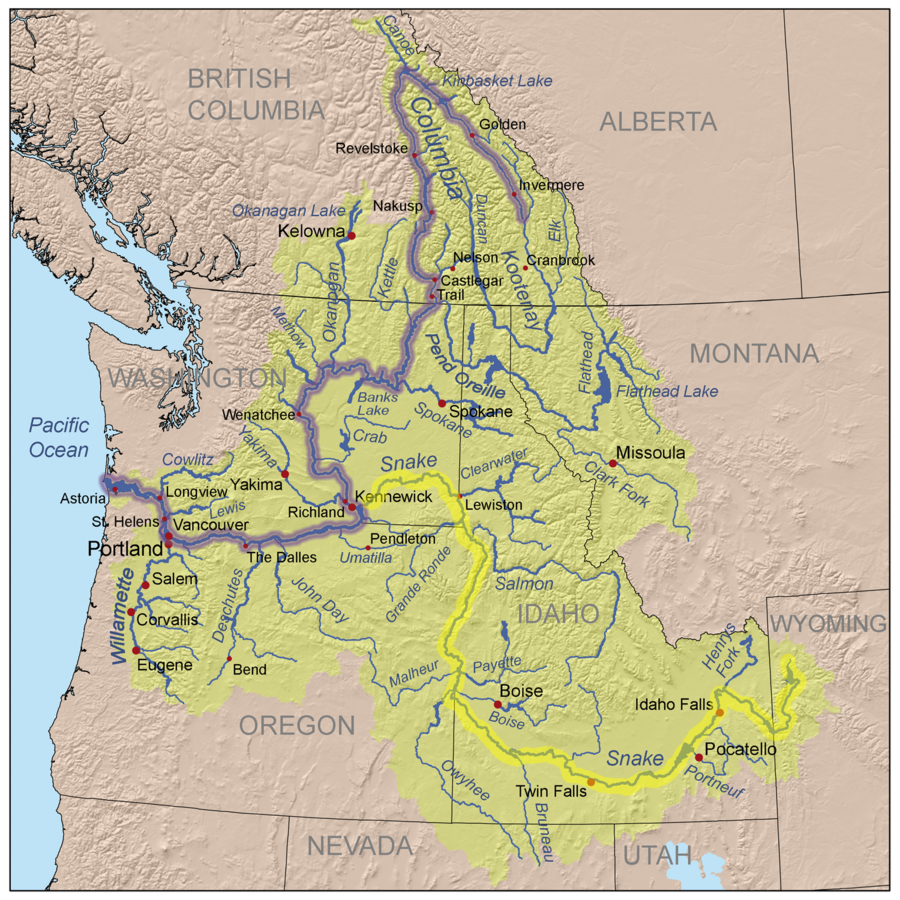
We mentioned the Pacific? In the Yellowstone area, some water runs to the Atlantic, as we saw. On the other hand, though, some water goes to the Snake River and then to the Columbia while picking up tributaries from Idaho, Nevada, Oregon and Washington. A major tributary of the Snake is the Salmon River. 

And from the Triple Divide that we looked at above, water comes into the Columbia through the Clark Fork and the Pend Oreille Rivers. 

Columbia and Snake Rivers

Remarks: Modified: 02/15/2025

02/15/2025 -- 

Tuesday, December 19, 2023

New Frontier, 21st Century type

TL;DR -- Technology is one of our themes. History and genealogy are a couple of others. General interests in the 400ths and the 250ths are others. Like, Gloucester MA did its 400th this year. There will be others over the next few decades. And, the Boston mayhem on a ship is now 250th.  

--

We were toying with various avenues of research which are endless in the modern age of the "cloud" despite its shortcomings which are many. For instance, in the western movement, we have looked in the vast interior and along the coasts. CA was a theme last year: LA and SF. We have looked at the middle of the country several times, in terms of the frontier and its settlement. In every case, we try to tie back to New England. As well, we are building a timeline by people and events that emphasizes individuals who are not in historical accounts and their families. That type of work will continue. 

So, today, let's take Minnesota (MN) and Kansas (KS). Both are west of the Mississippi River. MN is north of St. Louis which is, for us, the focal point of the dividing of the land. KS is about the same level. The northern realm has a different dynamic which we have started to study, through the Michigan Territory. KS was on the way west. For instance, the trails run through the State. Lewis & Clark (1804) came up the Missouri River on their way west. 

Cottage,
Round house,
Frontier in the making 
But, we are looking much later, after the Civil War. The image shows three things: a cottage in MN; a round house in KS; news of a new frontier. 

In MN, the town of White Bear Lake is named after its lake. We have run into MN several times in our research and skirted around details. But, for today, let's look at a famous cottage (ca 1868). It was built for Charles Phelps Noyes. His wife was Emily Hoffman Gilman. They're kin of lots of New England families that we are studying. That is the right time frame for some reflection on the Revolution (which was the 5th generation's deal) and on current themes. One thing to note is that Mark Twain liked the area so it got some press. 

Aside: recent post on Little Exeter NH (where two esteems of technology - and AI - went to school. The Society of Cincinnati has a house of repute in the area. 

In KS (and elsewhere), as technology, which is our focus, improved, the railroad replaced earlier modes of transportation. Several lines ran through KS from both directions. But, the photo is in the extreme southeast corner, in the little town of Cherokee. There were strip mines for coal in the area. What did these old iron horses run on? The photo is of a round house (ca 1888) which served several purposed. For one thing, one had to change from north to south, etc. Go to San Francisco and see these in action as the rail cars get switched to return. So, we'll have lots more about that area of the country that became the flyover country, later. We have shown, and will continue to do so, that the history of the country runs through the middle. 

Now history and genealogy? We are talking about an organization whose membership included John Quincy Adams. We had an earlier post about his cousin, Grizzly Adams, and a few others. They are offering a webinar on Using AI in  Family History Research. 

What they meant to say is that they are going to show technology that can be put to use. We are going to use AIn't to keep the discussion going that this state of affairs does not offer sentience nor intelligence in the important sense. It is very easy for the imagination to run wild with respect to these things; that is a human trait that we can value. 

But, as the NEHGS (their real initial) adds, in this: 

She will also address aspects of AI that genealogists should be cautious of, such as accuracy and copyright concerns. Join us as we explore this exciting new technological frontier!  

Okay, we'll take that. But, let's go further. The tricks are being done in a manner that we can understand as it's applied mathematics. People have been lazy and have let things get too loose. We will not use "fuzzy" as that is a legitimate logic and algebra. We will touch on that more. 

In the meantime, our thrust over the past decade is to fill in the 400 years of all sides (New Spain, New France, New Sweden, ..., Native Americans, ..., New England). Plus, the 250th of the U.S. is coming up. What happened recently? The 250 of the Boston Tea Party. Nope, it wasn't with china and crumpets. 

No, we're talking illegalities. Dumping someone else's product in the water. BTW, Samuel Adams, cousin of John whose son is mentioned above, was a participant. You know, later, we had John Brown. Guess where he was? KS. Also, who were his supporters? New England. So, we have a post on that as the Secret Six had to hide out when the Uncle Sam found out that the rebel was being kept by a few brave souls, one might say. 

So, yes, we will do history. But, too, we will continue our support for discussing and using STEM plus. What is the plus? Kant, for one. If you don't know him, you'll hear from us. Stay tuned. 

Aside, again, some think that the revolution was done by rabble rousers. Well, not. If we look, the King trained the men who took him on via their support of his French Indian affair. That was the 4th generation who supplied the leadership for the most part. But, the 5th bore the brunt. 

Remarks: Modified: 12/20/2023

12/20/2023 -- Ramsey County History - Fall 1997 - The Women's Institute and How It revived Downtown St. Paul - 'A Beautiful, High-Minded Woman' Emily Gilman Noyes and Woman Suffrage. She was a daughter of Charles P. and Emily H. Noyes. 

Monday, October 23, 2023

Lewis & Clark, again

TL;DR -- Today, a great map of the interior of the U.S. came up via a FB group who follows the venture of Lewis & Clark. In those areas visited by the L&C team, people living there now pay attention to the trek and the surrounds visited. This is an example of technology being used for a good cause. 

--

It is always nice to see great maps pop up. This one comes to us via a post today on the FB page of The Lewis and Clark Historical Trail. It is of the great interior of the U.S. which was traversed along its northern side in 1804/5 by the two gentlemen. At the time, TGS, Inc. and our websites did not exist. It is nice to see that the historic interest continues through local participation. 

Lewis and Clark Historical Trail 

Fortunately, the 250th of the U.S. is being celebrated through planned remembrances and active research. D.A.R./S.A.R. are examples of groups who are maintaining the interest and keeping up with research pertaining to families. 

Especially, we need to follow families, during the frontier century, who went west from the east coast, whether they had only recently arrived or were descendants of earlier settlers such as those of interest to our research. Or, whether they came from the northern or southern areas, we have an interest; our areas of interest are large when one considers all of the extended family relationships. 

This is an example of technology in use. We will be touching on that subject on a regular basis. 

Remarks: Modified: 10/23/2023

10/23/2023 -- 

Friday, June 23, 2023

Winter won

TL;DR -- As we track New England folks across the country and back, we note that information becomes available continually. The Woodbury folks pointed to the Wyoming History Society and their article on the Pony Express in which we have an interest for many reasons. This new source has interesting graphics of which we provide two. One is of the Butterfield (southwestern) route. The other has details about the route through Wyoming as research for the 1960 look back. 

--

As we follow New England's influence away from the east coast, we have to consider that left coast which was also accessible by sea and the huge middle. A recent post looked at the excursion of Hernando de Soto through the southeast all the way to Boone's Missouri. Then, we had periods of time from Lewis & Clark's jaunt onward with trappers and fur traders leading the way. 

A major theme for our posts which were done after some research has always been rivers. Then, we had looks at people, including other cultures such as New Spain. When New England was the origin, we tracked down their information, if available, on WikiTree and Wikipedia. And, destinations were important whether Oregon or Texas or any other of the current States. 

We also looked at the work of other researchers. Recently, we became aware of Woodbury Historical Tours. These are cousins via the Cape Ann venture. But, there have been lots of other researchers that we paid attention to, such as those with the Jedediah Strong Smith's society. 

On Facebook today, the Woodbury's pointed to the work of the Wyoming Historic Society. Anyone going west in the northern U.S. went through that region. One reason was that the mountains of Colorado were too difficult. So those headed to Oregon or California went up out through Wyoming and then split. We have had many posts on the various trails. 

Butterfield route 
through the Southwest
What was interesting about the article on The Pony Express in Wyoming is its focus on accuracy. They mention, of course, Buffalo Bill Cody but just cursorily. What caught our attention was the acknowledgement that "winter won" with respect to the effort to establish the Pony Express (which we wrote of last year) as a northern mail route. 

At the time, the Butterfield southern route was in operation (see  map). In our post, we tracked down the principals, one of whom was of the Giddings family of Ipswich, MA (Ann's kin). Too, we noted some of the other players who ended up founding banks and other businesses. 
 
As we saw earlier, the Butterfield route stopped when the Civil War brought too much uncertainty. So, the effort was taken back to the northern route which Samuel Clemens (Mark Twain) took out west in the days of the stagecoach. Ralph Waldo Emerson went out via train a little later. 

We will get more into detail, but the Pony Express did run in the winter. It took longer. The southern route was longer and arduous as it carried freight, to boot. We need to know of these enterprising people, many of whom were of New England stock. 

Let's just leave it with this map of the 1960 rerun. Plus, we will mention one of the founders: William Russell (Wikipedia, WikiTree) born in VT in 1812, moved as a kid to MO.  

Pony Express
Route through Wyoming

Remarks: Modified: 06/23/2023

06/23/2023 -- Reminder: research continues. Example open research topic.


Thursday, June 15, 2023

Hernando de Soto

TL;DR -- The west was won, as Hollywood says? Well not. It was carved up, though. Looking at research about De Soto's early journey (1540s) along the Arkansas River can give us some insight into the nature of the events that followed three centuries later. As one would expect, multiple views are there for us to look at while learning about American history and the long reach of New England. 

---

We like to follow the activity, virtually, of the Woodbury Historical Tours and have had several posts. We have posted and commented at the Facebook site. These are cousins of Cape Ann and Gloucester which is comemerating their 400th this year. 

Disputed paths, 
research views
They showed the following map from the Georgia Historical Society's article on De Soto's travels in the southeastern U.S. Several things caught our interest. For one, we are talkin the middle of the 1500s. Too, this deals with New Spain's reach. Then, this is part of the deal that the U.S. got with the Louisiana Purchase. 

Finally, looking at the left of the photo, we see Texas, Oklahoma, Kansas, Missouri and Arkansas. Not forgetting Louisiana, Mississippi, Alabama, Tennessee, and Kentucky, the Carolinas, plus Florida. Our view has been activity to the west of the Mississippi River. However, we will change that as up north of here, we will find Ohio and Michigan and other areas related to the great northwest. 

The legend in this view lists studies done about  De Soto. The U.S. founded a Commission in 1936. There were several reports. Let's look at one plus consider some of the human elements which are important to our studies. 
  • Final report of the United States De Soto Expedition Commission. This site is hosted at the University of Pennsylvania. The date is 1970. At some point, we can look more closely at the research. 
  • Soto, Hernando de, approximately 1500-1542. This page lists many sources for studying this person and his times. The following caught our attention. 
  • Scenes and Adventures in the Semi-Alpine Region of the Ozark Mountains of Missouri and Arkansas, Which Were First Traversed by De Soto, in 1541 (Philadelphia: Lippincott, Grambo and Co., 1853). Looking closely, we see that this deals with the travels of a geographer out of New England (its long reach is our focus). The following summarizes some of the personal details. 
    • Henry Rowe Schoolcraft (Wikipedia, WikiTree). Pick "Web presentation" which goes to a page at gutenberg[.]org's site where a book from 1853 is presented in a great format. 
    • The theme: Ozark Mountains of Missouri and Arkansas which were first traversed by De Soto, in 1541. 
    • Schoolcraft went to the area in 1816 and kept a journal. He provides fifteen chapters on his travels and turmoil. He spent three years doing his studies. 
    •  He provides more technical details (Mineralogy, Geology, and Mines; Geography; Antiquities and Indian History) in Appendices. 
Now, this is prior to the Missouri deal that also brought Maine into the Union. He got to St. Louis which was being set up as the headquarters for carving of the western land. 

As he travels, Schoolcraft references De Soto's work. Example: 

From the apparent vestiges in this quarter, I am of opinion that De Soto's "Tanico" must be located in this vicinity, and that he crossed the White river near this place. A march west of this point, over a hilly country, would bring him into the fertile valley of the Little Red river, or Buffalo creek—his probable Tula, where his people first tasted the flesh of this animal, and where he recruited his army for a new effort.

There are several things to note. For one, the White River that is mentioned can be thought of as related to Branson, MO. Most adults have heard of that entertainment area on the upper-west side of the Ozarks. Some mention Joplin in the same context. As the map say, "disputed paths" depicts the proper view, however we must not forget that this is real country of the U.S. settled, for the most part, after the Lewis & Clark expedition. 
One view, 
of many

Then, there are names given: Tanico; Tula. The image to the right provides some of these. The map is from the Georgia Historical Society's article. 

There is a lot to study and discuss. On a final note of the personal nature, the family of Schoolcraft's wife inspired Longfellow's poem about Hiawatha.  

 Remarks: Modified: 06/15/2023

06/15/2023 -- 


Saturday, April 29, 2023

To and from New England

TL;DR -- In 1794, Sam Dunn published a map of the territory of what was to be the U.S. The whole of the middle is empty. Taos NM and New Orleans LA are exceptions. These were of other cultures, namely New Spain. This map can be used to look at the period up to about 50 years ago (perhaps more); since then technology has been the focus as we can see with the current involvement with releases of what are called AIs (artificial intelligences). Too, early on people went west and south. The former got attention. We have a book, now, to start study of those going south. 

---

Earlier, we looked at a map of North America from 1794. It is fairly sparse in terms of information as the mapmaker was in London going on second-hand information. See post on Sam Dunn. But, too, travel was hard. The space was wide-open in a sense. 

So, this 1794 map will feature as we research the carving of the land and the participation of such by New Englanders. At the same time, the map will get involved with our discussions of technology. The U.S. grew from a small footprint to cover a wide expanse in 200 years or so. In the last 50 years, the focus has been technology of types. At the same time, the infrastructure decayed. 

Now, we knew of movement south from northern New England. This was an early18th Century phenomenon that halted with the advent of the Revolutionary War. In particular, known families left and went south and west. 

Movement picked up apace after the Lewis & Clark expedition. An example is the excursion sponsored by Ipswich of Essex County of MA. Veterans were restless; a good use of their energy was starting Ohio and other points west. 

Getting back to families, Melissa Davenport Berry, a writer on the history of New England, discovered a book that gives details about the movement of families from Nantucket to the south. It has the title of "Our Quaker Friends of Ye Olden Time" and is available on-line in the PDF format. The author was Edward Henry Hall, of the 1851 class of Harvard. The book's first part is "a transcript of the minute books of Cedar Creek Meeting, Hanover County, and the South River Meeting, Campbell County, VA" and includes births and deaths, marriages, and more. 

Then, an Appendix (pages 171-277) provides a "Historical Sketch" that is quite detailed plus some information on the Quaker views. Then, there are brief looks at prominent families and the publication of a diary.  

Remarks: Modified: 04/29/2023

04/29/2023 -- 

Friday, April 28, 2023

California, Golden State

TL;DR -- Our first bit of tasks dealt with learning about New England, especially little Essex County of MA. Later, we considered movement away from that area either to the south or to the west. And, by water, too, as that traffic had been constant from the beginning. After the Revolution and Lewis & Clark's journey, the expansion started in earnest. However, the interior of the U.S. is huge and took a while to be carved up. Travel across the country took time by land. And work. Too, water travel was full of its travails. With the 400th from the beginning, the 250th coming up relates to the U.S. being populated. California will get a little more focus as it is first by many categories. 

---

Our first mention of the Golden State was in 2015 which is the sixth year after the blog had its first post. It was a brief mention as we researched the Barque Bostonian owned by Henry Gardiner that wrecked in Oregon. The ship had been in San Francisco prior to that. But, we found out that it had also been in New Zealand and a number of other places. 

Then, about that time, while being at a lavender farm near Lawrence, KS and realizing that the trails had passed through that area, the thought was: did the students up on Mount Oread see the trekkers as they labored past? The post: Gardner KS (11 Aug 2015). We had seen signs while traveling but were overwhelmed with learning New England particularities. Even little Essex County was unknown to us and took some time for study. A year later, we started to update the information dealing with the western movement (Gardner Junction).   

Of course, given the drive to get to the gold rush as fast as possible, the CA traffic dwindled after the young guys figured that going up the Missouri River past St. Joseph saved them a few days. Rather than the circuitous route into upper KS and then heading northwest to NE, they just got off the boat and joined the trail goers after a shorter jaunt. But, traffic to the southwest (Santa Fe) still went through Gardner, KS as did some going to CO first and then joining the OR/CA trail in Wyoming. 

That deals with movement by land. While researching the early venturers (mountain men, trappers), we looked at CA, too, principally. Though, Jedediah Strong Smith got there in 1826 and was the first European to go across the Mojave desert (even doing so in the summer). Then, he mapped out the Interstate system with his wanderings before coming back to meet his demise in the Great Plains region. Along with and after him, there were other travelers that we looked at. 

But, there is an area that we have avoided, to dated. How did CA end up with its 1850 entry into the U.S.? For this historic portion, we will use documents published by the U.S. By 1847, the area of California was home to 150K indigenous people plus about 14K folks of European ancestry. Most of the Europeans lived south of Monterey, especially Los Angeles. San Francisco (then Yerba Buena) had a scattering, until after the 1848 discovery of gold at Sutter's who had arrived in 1838. In 1849, 100K additional people arrived from the U.S. and Australia, New Zealand and Hawaii. 

We will back up and look further at New Spain in California. Mexico had won its Independence in 1821. As well, we will look into the lives of the indigenous folks prior to and after the arrival of the Europeans. 

There will be more posts on this and other states. As well as New England States and Missouri, we have looked at Virginia, Kentucky, Ohio and Michigan which got started after the Revolution, mostly by restless veterans. So, we will cover the States, interior and along the coast lines. 

Remarks: Modified: 04/28/2023

04/28/2023 -- 

Thursday, December 1, 2022

Perspective, a necessity

TL;DR -- Ipswich has been a topic from time to time. It had shipwrights. Of course, different size of vessels were handled. There were no biggies like Boston (MA) or Bath (ME) or Norfolk (VA). Other examples of industry and technology can be used. But, Ipswich led the way to the expansion across the interior that we saw for over a century. We will be looking at that, as after all, New England has a long reach. Ipswich has done well for itself. 

---

As technology runs toward the future, we always get to states where we get locked in. We cannot go back. Technology is great, except for when it doesn't work. If the problem is solvable, then we have a glitch and a correction. If the problem is systemic or not resolvable within a reasonable timeframe and costs, we have adjustments rise as imperatives. Learning drives technology; unlearning drives recovery from technology's failures. 

The U.S. is about the best example that we have for several reasons. We have already addressed technology as being our main focus. We have 400 years of data to ponder, in this regard. But, just those pieces of evidence from the past 250 years is worthy of study, too. And, commemorative moments, such as we are having now which will last decades are a time to reflect and learn from the past. We are surely in a different mode than the generation of the recognition of the 300ths. 

Today, we are featuring Ipswich which does not come to bear until later, but it does involve Essex County. Reminder, Cape Ann (Gloucester) has their moments in 2023.  It was from Ipswich that a group went west. Gen. Rufus Putnam (Wikipedia, WikiTree) was one of the leaders of the effort. Let's look at some particulars. 

Historic Ipswich is a website that has been quite a motherlode of information. Of course, we are interested due to the many families in the heritage who had Ipswich connections. For one, Rev John Wise has an interesting bunch of  events in his life that we can learn from. We have been looking at shipbuilding in little Ipswich as well as similar work in the County (see Newbury Essex County MA).

The website has looked at Putnam's effort: Ipswich to Marietta, December 1787. First, they show the result of contention between the States with regard to this unsettled land to the west. We mentioned that in the last post about Family Search and their great support for research. Then, the post has the photo of a plaque that notes the endeavor. What? That got our attention, as we have been looking at the western expansion and its frontier century, including lost generations that plague genealogists who have no imagination. Why say that? These people were. Some were newcomers, true. Many were representative of the long reach of New England. Along with technology (and its specifics), our interest deals with identifying the examples of that reach plus the evidence now of its continuing existence. 

Then, the post looks at an effort in 1937 to redo the trek while documenting the effort. For one thing, they provide the map that gives details of the geography. That was great to see as we have looked at the west and its rivers and its great expanse and the carving that was inevitable. Lots of this was with a focus on St. Louis, the gateway. Putnam kept a journal. There were other reports written. In short, it was a great find that was more special since it involves little Ipswich (influence a huge multiple of its size). 

Now, let's look at perspective. Technology makes people lazy; oh, managers will say that it increases productivity. In terms of the former, heard of AI? It's a huge scam which we will show as we go along. Yes, balancing mathematics with knowledge with respect to culture that the broad history of U.S. allows. After all, we are a nation of immigrants. Luckily, we have two broad scopes, related to the colonial times versus later. Too, we have cultural associations with the old countries, for the most part. The list goes on and on. So, expect this theme to be recurrent. BTW, that which is being touted as AI is merely fancy math being exploited by computational prowess that came via modeling founded on (guess what?) mathematical modeling and the detailed work over the centuries. Yes, we will to touch upon all of that. 

For the time being, we will present the following map with some commentary afterwards. 


This graphic shows a map from the prior post which has one view of the partitioning before the carving that was involved in establishing the States. 

1) deals with the Michigan Territory (again, the prior post) that we just offhandedly dismissed as practice for the carving. Our only excuse was that we were dealing with the broad expanses beyond the Mississippi River, but that was not correctly assumed. We have to step back given that the focus of DAR/SAR is the upcoming 250th of the U.S. Besides, we have to give generations credit. This deals with the fifth and the sixth where the latter is the first of those that were heavily in the lost side of things. 

After all, people moved and did so quickly, once the way was set. Say, thanks to the likes of Daniel Boone and Jedediah Strong Smith. The former was doing his exploration prior to the Revolution. The latter was directly connected with St. Louis and its influence. We will go into that deeply. 

A point to make is this: that trek from Ipswich was difficult. Hence, there were real reasons why it took months. In fact, it was practice for the challenges of going even further which was all the way across the continent. On the right is a modern image with routes and times. Even today, travel is difficult. Try driving diagonally across West Virginia. It's fun; but, don't expect to make record time (except, perhaps, max time which is open). Those mountains run further north. By the time that they would use the Ohio, they had already trekked some distance. 

We will take the time to go into this further, since it does set the stage for later developments out west. 

2)  This view trails the other by only a couple of decades. Missouri, the starting point, was a State in 1821. By then, most of the issues related to the green area had been resolved. But, it was 1804 when Lewis & Clark did their venture from D.C. through St. Louis to the west coast. At that time, mountain men (trappers, explorers) and American Indians were mostly in the area. Except, that had been activity from the west coast in (New Spain), some of which got away from the coast. Too, the northern explorers had been more adventurous than those of New England. Boone in the south went further west than did those up north. Lots to discuss. 

Taking the same approach, notice that we are now in the middle of the country covering only a fraction of the area. Here, the issue is that folks would have followed a similar path down the Ohio River to the Mississippi River and then St. Louis and finally the Missouri River west. But, that was on to a starting point. There were several trails. This example uses that which went to Santa Fe in New Spain. One thing to note is that Santa Fe was the terminus of another trail that came up from the south. Too, there were trails out of the east through Texas to consider. 

But, taking that one small portion which involved about four hours of driving now, it took three weeks for a wagon train to cover that area with a daily grind of a few miles. Notice, too, that we are talking the plains portion which is supposedly flat. It isn't. You can still hurt yourself by falling off of a cliff at various places.  

In all of this travelling, rivers were both a barrier and a boon. In these graphics, they are not shown with any clarity, but, even recently, we have seen examples of traffic snarl ups due to bridge damage. One time, we were across the river from where we wanted to go. Okay. There was no ferry. This is a form of technology to note. So, the solution, since we didn't have a helicopter that would pick up the car and deliver us to our destination, was to backtrack to where we could follow a road that went over the river and then get back to where we needed to go which was a stone's throw (well now, as it was broad). 

During the times before bridge technology really advanced, one waited out water. Incidentally, here in the west, there are uncountable number of places where high water will stop traffic. And, in many others, the water comes up to the edge of the road. One hopes that the road engineers did a good job with the base. And, that's not mentioning storms such as we will be seeing with winter setting in. It does not even have to be like the recent dump on Buffalo, NY. A few inches can be catastrophic. 

 Oh yes, real examples. There is a method to that madness. AI and other computer has gone off the rail since a proper basis was lost. Yes indeed. We have seen so many examples of modeling gone wild (like the kids at spring break) due to a lack of grounding which comes about for several reasons. One of these is a lack of respect for the need. Some of that might be generational; a lot of it has to due with the computer being too new for us to really have a grasp of how truth engineering is necessary. Too, what John von Neumann wrought will bitt us until we learn several lessons that have been pending for a long time. 

You know, we are looking at the U.S. and its growth. But, at the same time, the world of thought was changing. There and here. Say, for the latter, Charles Sanders Peirce. But, parallel to the U.S. and its experiences, the world was changing, too. There is not end to that type of analysis. 

Remarks: Modified: 06/08/2023

12/16/2022 -- Rutland VT is hosting the Smithsonian's roving display:  The Smithsonian comes to Rutland. They are reading and discussing McCoullough's book The Pioneers as Rutland is on the pathway west. 

06/08/2023 -- Updated the URL for the Historic Ipswich post. It was originally dated in 2019. The 2022 update removed the older post. One of the technical concerns is that source linked by an URL can disappear or have some other issue, like the information changing drastically. Or, as we might wish not happen, contain undesirable information. In this case, an easy fix. 


Tuesday, November 22, 2022

Lydia Maria Child

TL;DR -- Over the 400 years of our interest, we will be looking at people and events, here, there and everywhere. That goes with the long reach of New England. This post looks at someone from the seventh generation who was involved with several matters of long-standing concern. L. M. Child is of long New England pedigree as is her husband.

---

Book reviews can be a great resource. We don't always pay attention, as life is full of multiple areas of concern that need attention. But, the WSJ (weekend edition of the Wall Street Journal) has been a constant supplier of reviews of good books, that is, ones pertinent to our interests. For this post, we can point to three of these. One is that the childless can become lost as who pays attention down the pike? Lydia and her husband had no offspring. We have mentioned this interest several times, say with respect to Joseph and Ann - see Aunts, Uncles, Cousins which is from 2012 and needs some updating. Note, though, others have been added, such as Charles Alcott Flagg, friend of Dr. Frank and contributor to The Massachusetts Magazine. 

There are a couple more interests of many which we will itemize and discuss next year being motivated by the next 100 after the 400th commemorations cease, down the pike. The other two interests deal with identifying Essex County (Cape Ann) influences over the U.S. and the world, even today. So, that entails recognizing names of New England families in various contexts and looking for the specifics. The other is to find family associations within the large collection related to Thomas and Margaret (Fryer) Gardner. In this case, we have already found some but will keep those particularities out of focus for later. 

WBUR (news station, Boston) provides the following quote. 

BTW, we are finding that becoming stale is the norm for the web links and their offspring. This usually is only an inconvenience until one considers that what gets into place after the target of the scale link disappears. That can be problematic and will be covered under the topic of technology going forward. 

Here's the quote: 

  • Lydia Moland: "Lydia Maria Child: A Radical American Life" tells the story of what brought Child to this moment and the extraordinary life she lived in response. Through Child’s example, philosopher Lydia Moland asks questions as pressing and personal in our time as they were in Child’s: What does it mean to change your life when the moral future of your country is at stake? When confronted by sanctioned evil and systematic injustice, how should a citizen live? Child’s lifetime of bravery, conviction, humility, and determination provides a wealth of spirited guidance for political engagement today. 

The Frugal Housewife
by Lydia M Child
Information about Lydia Child is available many places (Wikipedia, WikiTree). She is the author of a popular poem; too, she wrote The Frugal Housewife, an early example of self-help. Her parents were Convers Francis and Susanna Rand. With respect to point #1, WikiTree does not have her heritage filled in as it could be since she does had New England families in her tree. So, we'll look at that. 
 
It ought to be an interesting bit of research. We can start here, with the VR of Medford which is in Middlesex County under the "Francis" surname for which there are several entries. 
  •  Lydia, d. Convers and Susanna, Feb. 11, 1802. ["took, when baptized, the name Lydia Maria" [w. David L. Child, Esq.] "the author of several valuable works," PR13]
The 'Francis' surname appears in Barnstable, Berkshire, Bristol, Dukes, Essex, Hampden, Middlesex, Nantucket, Norfolk, and Worcester Counties of Massachusetts. Okay?

---

We have looked a little at Lydia and her family. Let's stop to consider the times that she was born into. Recently, we did a look at veterans throughout the time of the U.S. (see Veterans Day) and showed a graphic of the conflicts. According to that source, the Revolution ran from 1775 to 1783. Lydia was born 21 years after the end of the revolution. The next conflict started in 1812, so she would have been aware of that war. Also, we had next the Mexican War and the Civil War. Now, Lydia was an early abolitionist as was her husband. We will get back to that as the extended family had a lot to do with the opposition to slavery. 

As an aside, Great Britain started the anti-slavery effort which we will look into. The U.S. had some involvement in the industry of slavery but pulled out of it. Needless to say, slavery still exists in our world. We really need to give credit to the folks of New England (they are legion) who worked and gave their lives for the effort, as we continue the efforts toward a more just life for everyone.   

So expect that we will continue our efforts at identifying abolitionists and other positions to be applied to new material about new people plus we will be going back for another look at what has been done so far in this regard. 

---

On the other side of things, 1804 was the year that Lewis & Clark got their sojourn going. They went down the Ohio River to St. Louis before running up the Missouri River. People were already going west, mostly for fur trading and exploring in the beginning. Boone himself was doing interesting things. We will be touching upon these themes as we continue our research. 

One category to keep in mind as we go forward deals with generations. The fifth were the core of the Revolution. The sixth were born but too young. The early seventh is where we would place Lydia. As we fill in more information about her, we will post updates. 

We will look at the family of Lydia's husband as well as that of the Francis family using the time of Lydia as a reflective point. 

Remarks: Modified: 12/29/2022

12/29/2022 -- Ipswich, MA led the way in settling Ohio post the Revolution.