Showing posts sorted by date for query trails. Sort by relevance Show all posts

Saturday, October 10, 2026

Trains and planes

TL;DR -- Trains first, and then planes. These move from place to place, carry people and goods, or just amaze us like the fighters. Children play with toys representing these. The train is from our and helped build the country. The plane is later and serves similar roles but speeds up the process. 

-- 

Taking the engines of trains, first, as they're on the ground doing real work. The 250th has been an occasion to bring out some big iron. This type of locomotive was designed to up to a mile of loaded railcars over the mountains, in the west part of the U.S. 

Big Boy is Union Pacific 4014 which was built in 1941. This photo is from 2026 when a rebuilt engine started to travel the country while we all celebrate the 250th of ink on paper (declaring independence). It was several before the conflict was over with the Mother Country. 

In the photo, the 4014 was leaving Denver, CO. Its size is apparent from the photo. 

"rebuilt" was from the state of last use where the engine sat in a Museum. Once it was decided to revive the engine, it was taken to New York and dismantled. There are several things to look at with respect to that, including tooling, handling things of matter of this size, 

Big Boy, Leaves Denver, CO

Now planes are the topic. We have mentioned some aviation themes in out posts and will do more. This is where technology excels. But, the Big Boy is heavier than the Boeing 747 which is to be expected. One slogs along the ground for miles and miles. The other jumps into the sky and moves across the Earth to another site that is configured for its arrival and eventual departure. 


Big Boy moves about on rail. That was a topic as it was not until after the Civil War that the rail industry boomed. And, at a later time, there was one track of rail from the east to the west coast. We have had many posts on the technology and history of railroad 

To end this introductory post, as kids play with toys of rails and trains. Both are featured in children stories which includes multi-media. 

But, let's look at mountains. We have covered rivers for a while. These carry water out of the higher elevations. Some of those elevations were troublesome to early travelers. 

The Wasatch Range
viewed from Jordan Campus of
Salt Lake Community College, March 2006

That brings up another topic, namely Trails. We will look at another (Mormon trail) as we add to the list of note, Oregon, California, Sante Fe. 

Nowdays, one can still take a train from Denver to the west coast. But, the plane schedules are literally 1000s a day domestically. 

Remarks: Modified: 10/10/2026

10/10/2026 --


Friday, June 26, 2026

Early Road

TL;DR -- Right outside of Washington, D.C., is a lot of history. We like to pay attention to trails (becoming roads) and to rivers. An important road is on the VA side. Last year we mentioned that Gen. Braddock used it to get out west during the conflict that trained the US forces under the auspices of the Crown. 

---

This is a quick post to be filled in later. Last year, we looked at Gen Braddock and how he came through Northern Virginia up to northern New York during the Indian-French affair. Also, we looked at details of the earlier period. We like to consider the influence of roads and rivers (both a boon and a barrier) on the expansion of what became the U.S. of 250 years.  

The post emphasized the pre-1776 timeframe:

  • Lord Fairfax -- the focus was the Lord as owner. We mentioned Braddock since the beginning of his jaunt has been Alexandria VA which was about half-way to Mount Vernon of the Washingtons. Remember, this was of the earlier conflict where the colonials learned their military tactics under the auspices of the King's Crown.  
See Siege of Boston, about the colonials in 1775/6 not being a unruly crowd. 

Back to roads. The Vestal's Gap road was an animal trail and then used by the Native Americans and later by the colonials. Now, it consists of highways and even Interstate sections going from the Potomac port at Alexandria up over the mountains. 

Early in the 20th Century, Claude Moore bought land in Northern VA and worked to honor the colonial heritage through preservation.  

  • Vestal's Gap Road - By the late 1720s, the trail had been travelled enough to become a road. It eventually led to a gap in the Blue Ridge mountains, where an enterprising businessman named John Vestal operated a ferry crossing the Shenandoah River. A young George Washington used the road to travel to Winchester and points west, where he surveyed the Fairfax propriety for Lord Fairfax.
Lanesville Historic District

We have said that the 250th this year was of a conflict started earlier (even before 1775). So, on July 4th of 2026, remember please that the conflicts went on until 1783. 

Remarks: Modified: 06/26/2026

06/26/2026 --


Monday, May 25, 2026

Genealogy Trails

TL;DR -- Memorial Day will be a main theme for a while, especially as the 8+ years associated with the 250th unfold in the foreseable future.  We ran into Genealogy Trails today (again) and were intrigued for many reasons that we discuss. Of course, we love the "retro" look which isn't; rather, this site has been consitent over the years which we hope continues. 

---

We may have run into this website before, in our 15 years of research. But, we honored there request for not using their data beyond personal research. Of course that brings up the question of including the site in the reference list. 

As described below, looking at an Honors list for a State with casualties expeience during the Vietnam conflict found this site and got our interest. So, here is a link to the site prior to further exposition here: Genealogy Trails. Also, we note that we found this link via searches and backtracked at the site back to the starting page. Too, we noted the 2026 update of the Copyright. 

Incidently, we love that they have continued the older format. Why? The cute methods brought by the use of 'tAIn't methods is irritating. Underneath, there are table-like structures that get filled in. Then, there is some rearranging (within limits) for some semblance customization. But all of the sites using the ML approach look and feel the same. Actually, the convergence to a norm seems to be an apropos description. 

On the other hand, our portal notes our intent to foster and support "bespoke" methods in software. So, we're slow about it. Well, that's the human way. Those that run after the quick modes allowed by computation are perpetuating something that will not be pleasant in the future once the underlying errors start to creep up and bear out their potentials for negative influence. 

Okay, this year the discussion on Memorial Day was about service during the time of the Vietnam conflict. In particular, known casualties were identified. And, "known" means classmate or other, as this is that time of year for classes from the past to meet (this year, it's the 50th of the class of 1966.

Where were you then? As we were searching using names, we were gathering reports, such as the "Honors" listings for Counties and their States. Given our normal approach, we then looked at New England heritage with a focus on Essex County of Massachusetts our ground zero. 

Will not point to anything specific yet, but as we looked at the names New England families popped up. Lots of them. Well, let's use one example: Katy - western railroad. That was motivated by a postcard from early in the 1900s which was prior to the horseless approach. And, some of the buildings in the view had legible names. One name (Holbrook) popped out as it's part of an extended familythat we know. So, we followed up and reported the name of the owner/builder. 

We will do the same for some of the Honorees that ought to get attention on Memorial Day. We might merely have a table of the name, location and the information from New England about ancestors. There is no specific plan as of now. This post is to raise the link to the site plus attempt to use it for research when we help people with the family history that matches up with names on the Honores lists. 

Site: Genealogy Trails - this is sponsored by the

Genealogy Trails History Group

Their search engine: Our Freefind Search Engine

Page we landed on when doing our search: 

U. S. MILITARY FATAL CASUALTIES OF THE VIETNAM WAR 

FOR HOME-STATE-OF-RECORD: KANSAS

---

This weeks
finds ...
Finding this site is encouraging for many reasons. My favorite site was one from UCalRiverside and dealt with "weekly finds in mathematical physics" which looked 1995ish for a long while. It's still there for reference even though a new site has taken up prominence with updated material handled wisely with updated methods. 

The new site (Azimuth) points to lots of modern discussions (What are atoms made of?) and new data points. 

---  

We will be using this genealogy trails site on a regular basis to check out material in the early stages of research where we would use Wikipedia and WikiTree early on just to see what work has been done on the topic. What we know of the modern computational system is that, done right, it will be a great boon. Unfortunately, there has been more bane than boon in my view for the past two decades. However, there are signs that some effort at maturity might be at hand. 

Remarks: Modified: 05/25/2026

05/25/2026 --


Thursday, January 29, 2026

Kansas Day, 2026

TL;DR -- 29 Jan 1861. That was the day that Kansas came into the Union. We look at some information about the history. But, other States will get some attention, too. 

--

In this blog, we have mentioned many states, mostly those of the colonial period. But, the state of Kansas has been mentioned a lot, for various reasons. Its neighbor, Missouri, has featured as well. Then, Calfornia has had more than its share of mentions. Of the other states, Texas has come up several time. And, there are many others that we ought to consider. 

Well known area that impeded 
the travel along the Sante Fe trail
(courtesy of the Friends of Flint Hills)

A category related to States would not be a bad idea. We'll add it. Meanwhile, here are some of the posts with a Kansas theme. 
  • Kansas and Lawrence (2017) -- This post reminds us that the State was a project of New England. Some of those involved are mentioned, such as Col. TW Higginson. Another post describes the trip from New England of the folks who came here and got Lawrence and the University of Kansas going. 
  • Kansas Day (2024)  -- Theme of the 29 Jan 1861 entry of the State into the Union. 
  • 3 Trails (2019) -- This post was about Gardner, KS where the trails split after having started in Independence, MO. They went in different directions to Sante Fe, Colorado, and Oregon (California). Hundreds of thousands of persons passed through the site. 
  • KATY- western railroad (2021) -- Looks at the spread of the railroad through the southeast corner which has its own history. Several New England families who passed through or settled are mentioned. Holbrook is one example. 
  • Coronado of the early times (2023) -- The Spanish explorers were into northern Kansas back in the 1540s. So, the 400th of this place happened almost 100 years ago. A related story involved Arkansas and its river. As well, Pike of the peak passed through. 

What is this about? We will look to celebrate State anniversaries. Perhaps, we might look at the Northwest Territory first. That's the area around Michigan, by the way. In The Massachusetts Magazine published by Dr. Frank and friends, there was a regular report of families that moved to the area. 

Remarks: Modified: 02/28/2026  

02/28/2026 -- Chased down the image which disappeared. 

Thursday, October 2, 2025

States and watersheds

TL;DR -- We have lots of themes to research. Rivers will be a constant. Today, we look at watersheds, again. Too, we consider a map showing the findings of Powell as he explored the west. American would not be the same without its rivers. 

--

We saw a map today that got our interest. Perhaps, at some point, we'll link to all of our posts that present a map as we continue our look at the history of the U.S. and its first colony of New England (mainly north) being respectful of the Native American culture as well as the incursions of New Spaiin and New France both of which left placenames in their language. 

Rivers are the focus today. We have many posts in on rivers and some on watersheds. And, we mentioned the Arkansas River in an earlier post today. Before making a few more remarks, here is a map related to the discussion. 

The United Watershed States of America

On the page providing this map, one can click on the map and get an enlarged view. The Arkansas River goes from Colorado, through Kansas, Oklahoma, and Arkansas before it flows into the Mississippi. It was this location where explorers out of New France (north of New York) saw artifacts from New Spain. 

It's worth mentioning that New Spain explorers were in the northern Kansas area in the middle of the 1500s. This trek was to find the cities of gold. We have a town El Dorado not far from the route taken by the Spaniards. 

Back to the map, it shows the route taken by John Wesley Powell in 1869. This was post-Civil War when the traffic to the west increased. 

Another reminder, Jedediah Strong Smith was in some of these areas in the 1820s. Having gone from New England to St. Louis, he went west and ventured into the moutains near Gardner River. He went south into the desert of Nevada and crossed the Mohave in the summer (first European to do so) ending up in LA where he was the "guest" of the Spanish Governor. Once released, he went north and east. He met his demise in Kansas at a site along the Cimarron River. 

Later, Judge Francis M. Thompson toured the area. Tour, of course, meaning on foot and horseback. Like Jedediah, he got to the left coast. On the way back, he spent time in Montana and helped the State get is legal footing. 

In all of these journeys on the land, we talked of rivers as means for transportation (Lewis & Clark) or barriers to progress. An, example might be the Lawrence, Kansas-bound group that founded the University of Kansas - they had to cross the Wakarusa having come from Massachusetts. That meant, breaking down the wagon, lowering it, getting across, raising it back up to high ground, putting it back together and then continuing. The Wakarusa was fairy tame compared to the wild western rivers that those of the Santa Fe and Oregon Trails coped with. 

We can now consider another aspect of rivers. There are many more aspects, but the watershed aspect is important. An example are the irrigation canals of the west, such as those in Utah and Idaho which supported agriculture. Of course, we learned to tame rivers for milling and transportation of goods. Our post on the Gardner mill of Salem, MA is an example of a multi-purpose mill. The canal laid out by George Washington and his crew along the Potamac is another early example. General George Washington was at the Siege of Boston and became the first President. Even Betsy made it up to see him. 

Remarks: Modified: 10/02/2025

10/02/2025 - 

Sunday, August 31, 2025

Map and territory

TL;DR -- Concrete isn't something thought about with computers, except we know of one software package that used the name. But, we need to use concrete language and examples to hone intelligent approaches toward something that represents maturity. How to do that? We expect that New England and the US over time have plenty of examples. Real people doing real thngs. That will continue to be the case even as we see technology continue to expand and play havoc with stability, if we  let it. 

--

Last year, we had a post (Three weeks) that looked at early travel across pieces of the U.S. This was in the vein of our recent report on Knox's movement of tons of cannons from Fort Ticonderoga to Boston. His crew had to go two directions across New York and Massachusetts during winter months. And, this feat was accomplished during the time of the Siege of Boston which was part of the American Revolution that occurred 250 years ago. 

So, we are dealing with historic events which are of time and space. As a reminder, 100 years ago or so, Albert Einstein proposed a model of space and time that was confirmed and has been at the core of our model of the physical world. For the most part, that focus deals with cosmology though the science of physics has its quantum theory that has to deal with Einstein's equations of relativity. We can ignore all of the technical details and focus on some local events (explained below). 

The considerations technically handled by Einstein apply across the board which is part of the complexity of life. Another bit of adjustment, though, came with computing. We have written a lot about that and will continue. Of late (the past three years), lots and lots of attention (perhaps, too much) has been put upon GenAI/LLM. "AI" has been around since the '50s. The "Gen" part is 21st Century as is "LLM" which is the latest approach to handling language for input, control of the computer, and specifying output. 

For instance, there are ChatGPT (OpenAI) and Gemini (Google) and many others. We have sampled a few of these but kept it brief. Why? The approach is heavily dependent upon using resources by design. This did not have to be. There have been more efficient methods demonstrated. From our experience, there was not much new offered by this approach as we will see, eventually. 

Right now, consider this post and its graphics: Deadly consequences. In this post, there is an appealing image with respect to our work. The first reaction concerns what can be learned. Did someone do new research and find a gem? Nope, in looking at the image with a critical eye, things pop out. The raft is wrong. Some of the horses are badly modeled. How many errors are there? 

The point is that with this type of bad output, people can be fooled. On FB, one of the groups dealing with early LA (where our interest is DTLA and its Bunker Hill neighborhood) has had many images that were obviously fake but not identified as such. One rule needed? Anything done by algorithm needs to be identified with respect to what we need for verifying provenance. 

Note: Bunker Hill west in DTLA was named for the Bostonian mound of much fame. But, our interest is in the long reach of New England where LA provides us lots of examples. We like Bunker Hill since from the time of New Spain/Mexico to now, New England had a heavy influence. Several generations of buildings are represented in this area that pertain to a proper study of the history of the U.S. 

So, now to the point of the post. This image I put together for the "Three weeks" post. The gist of the matter is that a group traveling along the Sante Fe trail across Kansas would have taken three weeks to go from Indpendence MO to Fort Larnerd KS with the grind of daily travel.


Now, we will discuss each of the pieces of this image in terms of map and territory. Nowadays, advanced computing likes to demonstrate its prowess in modeling nature. Then, if that model is good, the computer can control something in the world. Take autopilot. This software can take off and land a plane. Now remember, involved is a lot more involved with this. We use "map" for the digital model in the computer and "territory" applies to the outside world. So, a control item on the wing of a plane would have means to feed back to the computer about its status and then take instructions from the computer to make some movement, say for a turn. 
 
The recent visible demonstration of this is the auto-car that can drive itself. Some do not even have a steering wheel. In the case that human input is needed, it can be handled by interfaces common with computer games, such as joy sticks. 

There is something called the map-territory problem (Wikipedia; John's Truth Engineering site). In the auto-car, too much reliance on interpolation between points on the computer could result in it not knowing the proper position of the car. There are many ways to discuss this, but, in general, when people are dealing with "smart" systems, it is very easy to forget where some data originates. Handling critical conditions in the world would put more emphasis on the local condition. But, what if a person is not there or incapitated? 

That is why the discussion is always in scope. Fortunately, most software development processes run through these types of things and determine how to handle, before the fact. People in the world do this but also have to think on their feet. The computer cannot do that, in general, despite the claims that we hear. Some reports might come from someone who does not know that they're engaging in a fallacy. It's not so much a matter of "truth" as it is of verification and all that such entails. 

John also has a site that discusses complex systems and the computational problems faced with these. It's called "7 'oops 7" and considers map-territory from a different angle which relates to abstraction and generalization. Frankly, this site pertains to GenAI/LLM's problems more than truth engineering given the present situation.  

---

Now, let's look at the top, middle and botttom of the image. All images are from Google maps with annotations. 
  • Top - The blue line represents a current bit of highways from the Kansas City area to Fort Larnerd. The post on KC provides another map and details This follows the Sante Fe Trail which went from the KC area to Sante Fe NM and was followed by thousands of wagon trains going in both directions. Too, the travelers could have come from the east coast or from overseas. Many came though St. Louis MO. This blue line represent three weeks of hard, daily travel. Even at this point, one still had hundreds of miles to go to get to Santa Fe. The modern trip planner says that one might expect to spend about 5 hours doing this journey. 
    • The topic? In this time, there was no map beyond hand-written sketches. There were models. The guides and wagon masters knew the route. Choices had to be made during the travel. As we know, weather changes and can do so drastically. Many water ways had to be forded. Along part of some trails, there were ferries that were basically flat barges that could carry weight across the water. 
    • With respect to territory, as well, energy was expended by people and their animals to do the traveling. After hours of travel, one had to set up camp for the night, feed ones self, handle maintenance task related to the living or the inanimate. Most wagon trains had guides and hunters who could acquire game for food if such was available. But, in those hundreds of miles along the blue line, the territory changed drastically. In terms of gear, wheels broke. One thing about crossing a water way, many times there was a need to tear the wagon down, cross the waters (bringing the gear in the wagon - several trips) and then put things back together in order to continue. One modern term related to this is logistics. We see semis running down the road touting their expertise and efficiency.  
  • Bottom - The blue line this time shows the trip from St. Louis MO to San Francisco CA. Quite a jaunt? The modern estimate is 39 hours as it is mostly on higher speed Interstates. But, this was also several weeks of travel covering a larger territory as the vehicles were stage coaches. We will be looking further at this line as there were several others. But, this one was three weeks from St Louis to DTLA. We mentioned Bunker Hill west above. The stage line came into LA in that area, where people could tidy themselves and such. Then, the trip continued up the coast to SF. At that point, there was then a return trip covering the same territory. 
  • Middle - The two images set up the condition of three weeks of constant travel across the US. The slower on never left one State. The faster one went from the middle of the country to the coast. That's pointed out with the red lines on the left. The trail to Fort Larnerd was three weeks of grind and danger. The STL to LA to SF trip was no joke either. We will go into that later. Passengers bounced on hard springs, the carriage was open to the weather (unlike the modern car), and people had to keep hold of their belongings which could go flying out the window. The horses and drivers were doing the work. 
    • Again, the territory reigns here. The drivers need to know their way which is a map issue. In many cases, the coaches even traveled at night as the trails were marked. Yet, there was nothing like modern pavement. Too, even KS has hills, creeks, and rivers. This is more pronounced with the western route across the country which had to pass through mountain passes which are more benign than one would have found in CO (which even today has many areas closed over the winter season). 
    • We added in the black line which crosses the waters back to the source of New England's population at the time of its start. We can speak of two ways to go. A cruise line of a modern type can travel that route in a week. Mind you, back in the 1600s, this could be months even if only a few generally. But, nowadays, in three weeks, one could take three of these trips. Granted, modern travel brings in more interesting issues of map-territory. Mainly, the cabin crew would know where the ship was and its heading. Passengers would have to know the "lay of the land" of the ship in order to get around and enjoy the cruise.  
This was to emphasize the reality of the ordeals of our ancestors which we can easily forget about with the ease of life brought by technology. But again, someone keeps those technical efficiencies going. That's a map-territory issue, as well. The purpose for this post is to explain why we are using the TGS, Inc. framework to discuss technology and its issues. Well, the map-territory mismatches are prime examples and can be used to explain how problems arise. 

Take vibe coding or prompt engineering. The human has the maps (knowledge) and, for the most part, the territory. Robotics with change this dynamic but has its own issues which we'll get to. The interchange by language or other input is part of the system. But, the computer has no notion of the territory in other than the "map" sense, using the word loosely. In fact, with respect to coding, there are issues of how pulling together fragments from the past being coupled with tests as the evaluation scheme can do more than a gross approximation. 

Frankly, I see this with increasing frequency as GenAI/LLM's influence grows. Take website. They look good. The semantics is way off, to say the least. The hard partt? There is no one to talk to about this and the interchange with people has been cut off with bots being asked to take over. I see it operationally, as well, as logic is not quite up to snuff as it was released using other than mature and quality-fluent methods. 

One final bit would be to add in aerospace to the middle image. Where the cruise takes days, a modern jet of capacity can traverse the spanse in part of a day. One can expect that a good airplane could go one way in the morning and return in the afternoon (notice we're talking NY to London which can range around 7 to 8 hours plus or minus two or three hours - fuzzy math - Zadeh's, so being serious). Then consider the map-territory issues of flying which again range widely with respect to the crew and the passengers. 

This example uses something real in the context of Kant's emphasis on experience for knowing. Human life is full of real territory examples and the map examples prior to GenAI//LLM. The computer has been complicating things with that accelerating in the past three years. Concrete examples are going to be important. Meaning, in part, that some of our work now will be to explain errors that crop up and to use examples to explain. 

That is, appealing to "black box" issues cannot be taken at face value. That is a copout. I see lots of discussion now about the mathematics of GenAI/LLM with some of it ex post facto. That means that people have taken the initiative to build an analyzer to do comparative analysis after the fact. Some of this is very encouraging as this could have been done before.

You will hear me argue that the past three years would not have happened had the "knowledge" processing work been allowed to continue. And, my example will be KBE and its contributions to engineering. At the same time, there were many other examples. These, incorporated into the model framework, will settle down that which is fueling the hype so that we can get real work done. 

Remarks: Modified: 08/31/2025

08/31/2025 -


Thursday, June 12, 2025

Lord Fairfax

TL;DR -- Little known facts are around and about upon the landscape of the U.S. Our normal attention is west (west is best; east is least - sort of thing ;>). However, there has been and will be attention to the eastern activities as the western part came about 150 years later where the Revolution became a central theme. This post touches upon the time that Braddock came over. Evidences abound due to preservation efforts. Otherwise, the landscape has been abused (data centers abound, for instance). 

--

We had to mention the 400th (Jamestown, et al) so as to set a stage that will be permanent. We would not have had the 250th without the earlier phases. So, Fairfax? His name is all over northern Virginia as are others of the upper class (kin/cuz, as well). But, the main thread will be dual. For this post, let's use "French, Indian affair" which we have touched upon before. 

While researching people who went out west from the older east side of the country, we had to bring in other cultures, such as New France and New Spain. From each, the U.S.obtained land that had to be incorporated into the Union. Too, there had to be maps that to allow reasonable control of land use (or misuse). We looked at some of this in a post titled Practice for carving about the work that went on for decades, starting in St. Louis. 

Now, in the interior, we usually think about things that happened after Lewis & Clark and the War of 1812. However, there was earlier activity out there by Europeans, for the most part related to involvement as trapper, trader, and rancher. In that regard, prior to what we are now celebrating (the 250th anniversary), there was the conflict that trained colonists for the coming Revolution. 

Namely, we consider the French, Indian affair which seems to have been mostly forgotten. Dr. Frank wrote about this conflict in his series on the Regiments that were at the Boston Siege. But, stepping back, we have had posts on this affair.  A grandpappy kept a diary that was later published: Nathaniel Knapp's diary about his time with the Louisbourgh Expedition. Some who were involved participated in the later Revolution, many times in a leadership role. 

--- 

With the French, Indian affair, we have taken a New England focus since Quebec was the principal establishment of New France. But, the conflict involved all of the colonies. An example is Virginia. 

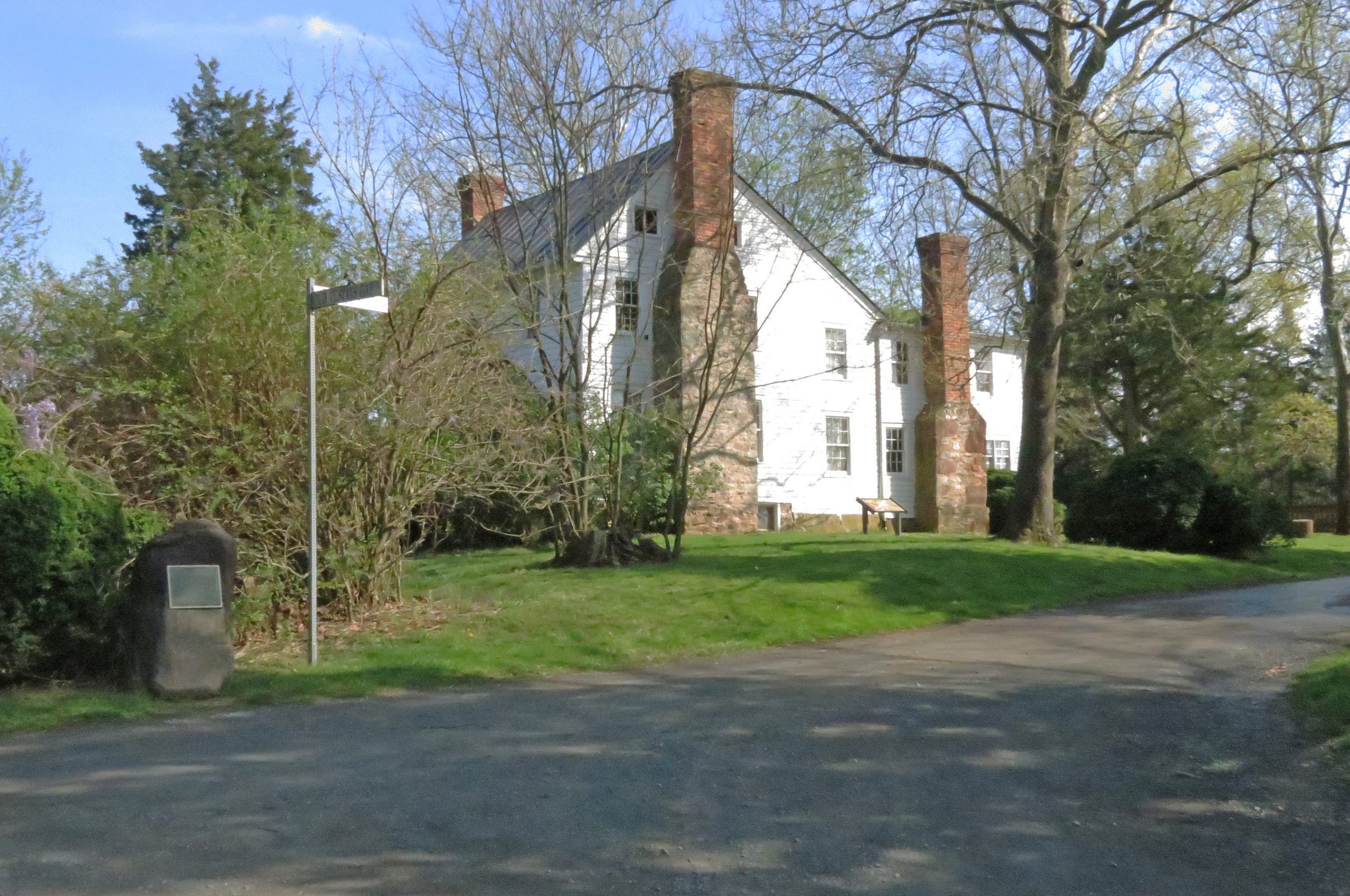
Today while at a park, we read a historic sign. It mentioned Braddock. But, being in Virginia, there were two other names of note: George Washington; Daniel Boone. We last mentioned the former (Washington) here in this blog in a post on Col. John Glover who was featured in the series by Dr. Frank. But, Washington mapped and surveyed the Potomac River which we have to consider further. This post is a start as we have covered many of the rivers of the west. 

Now, the latter (Boone) has been mentioned many times in posts about the early settlement of the west. Boone, well-known explorer: opened a pass; served in the French, Indian affair and the Revolution; settled areas from the east to western Missouri; ventured out into the west.  

---

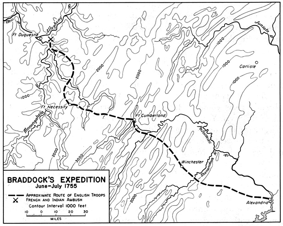
Washington was also involved with a conflict between the British and the French. The resentments that led to the Revolution are thought to have resulted with the arrival of Edward Braddock  and the reaction of the colonists to his methods. One of Braddock's early campaigns involved a planned attack on Fort Duquesne, French facility, near the start of the Ohio River. This expedition did not go well which left lasting impressions on both Washington and Boone. Braddock was mortally wounded which meant that he had no say in subsequent matters nor in the trashing of his reputation. 

---

Braddock arrival into Virginia was near Hampton Roads. After some meetings in Virginia, there was preparation for the attack on the Fort. Now, accomplishing this required going over a moutainous region that impeded traffic. Washington was familiar with the area due to his duties with the surveying crews that mapped the Potomac. 

But, let's look at the route that was set up for Braddock's forces by using a couple of images. 

Braddock's route from 
Alexandria, VA to Braddock, PA

Braddock's route from
Cumberland, MD to Braddock, PA

The first images shows the "approximate" route from Alexandria (on the coast) which is on the Potomac to the final destination near Fort Duquesne. It passes through the interior of Northern Virginia and climbs up into the Blue Ridge mountains. This map gives us the elevations. At Cumberland, the elevation is much higher, and we see the route through western Maryland into Pennsylvania. 

---

Braddock's route went through the Keyes' Gap which is over 900-feet high. Formerly, that route from Alexandria to the mountains was called Vestal's Gap. Parts of the trail can be seen in eastern Loudoun County of Virginia. This area is near Dulles Airport outside of Washington, DC. 

The route follows an old Indian trail which is 65 miles in length from Alexandria to the  mountains. 

---

In terms of historic preservation, Loudoun County has provided historical markers with notes in the area. Too, they have a website which is of interest. This is an example of the web/cloud being useful to education at several levels. One example (2019, LoudounNow): 
  • In Our Backyard: Preserve the Vanishing Vestal’s Gap Road - property of Lord Fairfax, originally, almost 400 acres are preserved surrounded now by heavy residential and commercial development including Dulles International (and recently, the heavy foot of data centers trample the countryside). Pieces of the trail still exist (with an interest not unlike those remnants that we can see of the Santa Fe and Oregon trails in the middle of the country. 
We have written of New England (south) for several reasons, such as people from New England (north) going south. As well, the culture is the same. The south was more swashbuckling and plantation driven, not that the north was heaven on earth, let alone a beacon as desired by John Winthrop. 

Now, finally, for this post, the Native trail ran from the coast up into those things called the Blue Ridge mountains where we find things like the Shenandoah River and artifacts related to the Civil War that was mentioned on historical markers too. Right by the above-mentioned site runs a modern highway that was prototyped (real life) in the early 1800s since the traffic was heavy. It bears the name, in areas, realated to one of the early towns. 
  • Leesburg, Virginia - county seat of Loudoun County. Town of the Carters, Lees, and Masons. was in an area that was good for farms and plantations. In the War of 1812, federal documents were brought from DC for safety. 
As we proceed being involved with the eight years of the 250th and then the long trek to 1820 and Boone's western influence taking hold, there is no end to the topics to cover. One theme will always relate to the influence of New England and it families that contributing to the establishment of the U.S.  

Remarks: Modified: 06/26/2026

07/31/2025 - One of the Lord's American cousins was George Washington. We need to look more closely at the relationships between those here 400 years ago and those of the 250th being celebrated.

06/26/2026 - Updated URL for the Wikipedia image (one change - number of pixels). 

Sunday, June 1, 2025

2021, time of the pandemic, II

TL;DR -- Continuation of the pandemic theme from before. We look at posts from the remainder of 2021 and at the themes covered which are of a wide variety. 

--
Part 2 of 2 (Part 1). 

In 2020, restrictions changed our activity. Like most, we did computer work over the time of the pandemic but had been doing such work anyway. What was different was the focus. 

We looked more at local issues. But, we had anyway (to wit, our post of Flyover country). By 2021, we were rolling along and did more posts. Part 1 looks at those from Jan through Jun. Now, we'll pick up with posts from Jul through Dec.

The 250th came more into focus. We also spent a little time looking at S.A.R. which is the sons version of what the daughters did with D.A.R. But, AI started to come into focus after almost a decade of making headway (according to some views - the jury is still out) and claiming attention: Jeopardy win; Go win; modeling complicated lab work (Google had several of these); ... 

But, we had a post (Carving the land) which was motivated by our study of the activities out of St. Louis which was a hub for land management of the U.S and its west.  At the same time, Gloucester was approaching its 400th. We had an interest in that as the Dorchester crew came into that area in 1623. But, the great northwest? Michigan was approaching its 200th. 

Another twist was diving into the history of Harvard starting with an introduction to James Bryan Conant. He was a chemist and professor. He had wanted the Rumford chair. But, ended up in Europe and came back to become a Head of Harvard. At the same time, we decided that the long reach of New England was a theme of interest, as we had settled on All Things Gardner (22 Aug 1485) with respect to the many families with the name. 

Oh yes, AI was proposed for genealogy work. Again, that is an ongoing bit of study. But, we started to look at the genealogy of Harvard Heads. Many were of old New England families. D.A.R. found an interest in the 400th as well by starting work on identifying Patriot to Passenger (in this case, Mayflower) families. We took on Cape Ann to Patriot. 

Houses? While looking at the Dudley family, we got into houses of note. There were two in New Hampshire of interest. Both were built by relatives of descendants of Thomas and Margaret. One is now associated with the Society of Cincinatti. That brings up the other side of a coin. We honor the Loyalists of the family. Count Rumford mentioned above was a Loyalist who found success in Europe and left money to Harvard. 

The technology focus became more prominent. IEEE had an article: How dumb is AI? A few years later, we saw a general amount of interest. One observaton? Humans degradate themselves to make technology look good. Yes. Expect to see that theme periodically. 

A photo of the grandmother Dr. Frank (and 2nd great of Ann and her siblings) was found. We got that published. Generations? An eternal topic. Looking at this, we can say that the Revolution (250th now in progress) was done by the 5th generation. More on these. 

We picked up Dr. Frank's series on the Siege of Boston that were published in The Massachusetts Magazine, with issues four times a year for a decade. He started the series with Col. John Glover of Marble head. One of his vessels was the first vessel of the U.S. Navy. 

We continued our interest in rivers, as we mentioned in Part 1. The trails and railroads are always of interest, as well. But, jumping to technology now, we looked at John's favorite site dealing with the mathematics of physics. It was of the old style until a few years ago. The old stuff is still there and serves as the basis for the new. 

Aside, we are seeing lots of websites being done using new methods. Our prediction is that this method is not as stable as claimed and so have failures that are hugely visible and that will have negative repercussions. But, other than be aware, we have to wait and see. 

Why? If one looks at the whole campus of techies, there is no solution yet. Experiments have become a mainstay of life. But, take a plane, experiment types of these are not used to carry passengers. 

Remarks: Modified: 06/01/2025

06/01/2025 - 

Saturday, May 31, 2025

2021, time of the pandemic, I

TL;DR -- The pandemic started. Life was restricted. We did local things. And, worked on the web/cloud in various modes. 2021 culminated in the most posts that we had since our start with topics that cover a very wide range. Knowing the U.S. and its history is one motivation. 

---

Part 1 of 2 (Part 2). 

In 2020, we found out about the coming restrictions after being in one of the cities where the disease was reported and said to be related to someone returning from overseas. Then, we endured the restrictive period with access to the outdoors as well keeping busy with "web/cloud" activity along several lines of research. 

Our focus on technology was one line of study for the Thomas Gardner Society, Inc. The next year, 2021, had the most, 105, posts published since the start of our work. Below, we provide a list by month of the titles of the posts. As can be noted, the topics varied greatly which we will comment on below. 

First, here is a list of the topics for the first six months. 

A subject of lots of focus was the travel of folks from the east to the west through the middle. Of course, looking further at the west coast got our attention to New Spain. The rivers of the interior were of particular interest as the Missouri River starts out in the far western mountains, closer to the Pacific than to the Mississippi River which it joins at St. Louis. Not far from there, the Ohio River comes in from the distant east having started in Pennsylvania. But, there is more. The Arkansas is a little south of that area and had eastern visitors from (what became) Canada early on. That exploratory group from New France headed back up north when they started to see evidence of New Spain. 

Naturally, looking at the Missouri, we had to consider other rivers near its origin, such as the Gardner River (Yellowstone, plus) which flooded recently. We looked at several tales related to the area, including that which motivated the movie, The Revenant. Our earlier focus was there, namely Jedediah Strong Smith. 

Going back up north from the Arkansas on the Mississippi, we get to the Wisconsin River that joined above St. Louis. The French group had traveled over the Great Lakes to the mouth of the Fox River. About one-half way to the Mississippi River, there was a portage which was brief, comparatively, being only two miles or so between the Fox and the Wisconsin (on the western part of the trip).  

In work related to family history and genealogies, we decided that there was a frontier century which is observant now with respect to missing documents. St. Louis was a hub of movement. The U.S.Government was early there with land management. Think of the time of Daniel Boone who was out, with his family, to western  Missouri (Kansas City area) as a settler. But, he also ventured further out past the Rockies. Other federal activity was military: Fort Larned, KS. 

Speaking of which, there was a stage line that ran from St. Louis to San Francisco. Not across the middle of the country. No, this one went south and joined regular movement from Texas to Los Angeles through Tucson in Arizona. In Los Angeles, the activity was in the Bunker Hill West area which has a long history that we have written about (Mirror building). Of course, then we had to look at mail and freight. Too, newspapers were delivered. 

We didn't forget the sea as the California cities were largely populated by ship in the beginning. Once the internal trails were established there was a huge flow across the middle. The Pony Express carried mail and small material. Several stage lines carried people and freight. We looked closely at the Butterfield Express. 

Why? All of this activity was seriously associated with, or driven by, New England influences. In fact, Kansas was a Massachusetts project with its University being founded by a group that included women who came to set up a free State. We have a lot more to write of that. 

Everywhere in the unmapped territory, we had trappers. Some were even venturing down from New France and Canada. Then, the next phase was trader as folks moved across the country, many of them stopping at locations that exist today having been started by the pioneers. 

Along came the railroads which have a special interest due to family involvement. That facilitated one of the major memes of the west, driving cattle to the markets. So, rancher/farmer would be the next phase continuing today, in the flyover country (had to menton that - it's from an earlier post). 

Next up, we'll look at the second half of 2021 in terms of posts. These posts cover the U.S. and its history. Interspersed are posts on technology, which increased with the release of OpenAI's GenAI/LLM. 

Remarks: Modified: 06/03/2025

06/03/2025 - Clarify that the journey on the Fox to the Mississippi starts at the Great Lakes and runs upstream in IL to a point where the Fox is close enough to the Wisconsin for a reasonable portage. The Wisconsin then runs down, and connects, to the Mississippi. In the reverse, the journey goes up the Wisconsin to the portage and down the Fox to the Great Lakes. Modern technology has improved that route with locks allowing the height changes to be managed. 


Thursday, April 10, 2025

A trillion cuts by GenAI

TL;DR -- We saw a Chrome report which featured Gemini with respect to Gardner KS and its role in the trails west, one of which was the Oregon Trail. And, the report was not right. "Who cares?" has been my response to having Gemini spout off. I ignored it like I am very good at doing with ads. But, today, I read and saw errors. Okay. What to do? There is no method now. People are training these things. I say, you will not train out the crap. Okay. I wrote this post as an intro and was going to snap the Gemini report and mark it like a teacher would do an exercise. Oh, Gemini, my sweets, you left without telling me. What?  

---

Our purposes are several. An important one we have named as All Things Gardner. There are lots of families with the name Gardner. "What's in a name?", we asked once: Amelia Earhart. 

We have been at this genealogy and history work since 2010, learning as we go. On the other hand, we have decades of advanced computing experience under our belt (mainly, situations requiring precision). So, our work here has been largely abetted by computing which has changed in so many ways in the past 20 years (2 decades of decline in some areas). 

We have striven to be correct as to former work. But, we know that is not sufficient. Technology has aided in the digitizing of old records which have been analyzed via human effort and mechanical means such as OCR. A case in point is that we do not know the origins of Thomas Gardner about whose progeny we know a lot due to records over the past 400 years. So, that is an issue to resolve. 

As we work the solution, we have adopted a category: OpEd (category). That will be used to label any of the former posts that touch upon the subject. The information will not be entirely wrong. So, when we figure out the corrections we will make them. Until then, someone can still follow our approach and analysis as we looked at new material. 

Aside: the genealogy crowd split Thomas Gardner into two guys, one who was at Cape Ann with the Dorchester Company and one who is the ancestor of a whole lot of folks. Myself? I think that they are the same guy or were father and son. Both of those alternatives have some basis. The intent will be to find the truth: A Thomas here and a Thomas there. 

And, we would like technology to be of assistance. And, it can. See Bosworth and Gardner, with new revelations coming about of late through use of the facilities of Grok. How well this will stand up though remains to be determined. The battle settled the 100-year war (some use, War of the Roses - I say, cousin war - needless bickering). 

Anyway, this post will look at Gemini which we have liked. But, it is now on the top of a search report. And, I was trying to look at Gardner, KS being right this minute not far from that place. We have had many posts on the little town which we have buzzed by on I35 for countless times. 

---

Now, that was an intro. Here is the gist of the post. This image was snapped from a Chrome query today. ... Wait, did not snap the earlier search. Now, Gemini has disappeared from its featured position. 

Inserted as placeholder 4/11/25 0457 AM CDT
--- 

Note (04/11/25 0458 AM CDT): the absence stopped the flow. "How to handle?" was the question. The following text is from the post from last night. The image was to show what Chrome was presenting. 

---  

Actually, earlier, when I read the Gemini summary, I scrolled and found this first on the list which is from the National Park Service. Gardner was a stop on the earlier Santa Fe trail which was largely commercial going from St. Louis as the gateway to New Spain. 

That trail passed through Independence MO. So, Oregon traffic followed that same route to Gardner and then turned to the north and west going by Lawrence KS which is the site of the University of Kansas which was founded by a group of New Englanders who came out, including women, by that same trail through Gardner KS.

Later, young bucks in a hurry figured that they could take the Missouri River north from Independence past St. Joseph MO into Nebraska and head west from there. Guess what? They eventually met up with the travelers who had come up through Gardner. What did the folks in a hurry gain? Maybe, two days, perhaps a little more. 

But, gold gets the blood boiling. Like? Things easily hyped. 

Note (04/10/2025 2100 CDT) - On going to the Google development mode, I see that there is a new button ("Vibe") which I have been reading about. Sometimes, I might add as it sounded like the usual affair of misdirected enthusiasm. Whatever is going on in the background with this problem will settle down. Then, I'll use this topic for a deeper look. In any case, running into a "tantrum" however invoked does not make for stable knowledge processing. 

Remarks: Modified: 04/11/2025

04/11/2025 (about 0500 CDT) -- Put in proxy of the expected image and a note to explain. Something related to "Who moved my cheese?" (when did that become normal?). 

04/11/2025 (0738 CDT) -- It's back, AI Overview. But, buried under a label. The only quibble is the use of intersection for a split. I dealt with precision in highly technical engineering support work (computational modeling). 

Kudos, somewhat. Let's talk.


Monday, March 17, 2025

Independence and Kansas City

TL;DR -- Trails were and still are in the sense of leaving tracks on the landscape (several places along the Santa Fe and Oregon Trails. And, now the Interstate Highway system with all of the national, state, and local roads. And, going further, even now dirt roads as tracks. Sometimes converted railroad tracks. 

--

With all that is going on in the world, and in the U.S., it is time to look back at the past. In 2020, we got the opportunity to spend time looking at the interior of the country which is huge. In terms of time, we had a frontier century (post has copy of photo of Lawrence, KS by Gardner). We got to learn about the trails and the cities that cropped up (theme of this post). We determined that there was a lost generation or two (Boone was real; officer in the US Revolution; Longhunter; traipser of land (all the way past KC with time spent in western MO) in the movement that came to fore as we looked at the upcoming 250th of the US under the auspices of the Daughters of the American Revolution. Doing applications for some requires lots of additional work. 

Before 2020, we had looked at the trails and those earlier like Jedediah Strong Smith. Gardner, KS was seen as a hub of traffic and activity. Also, we had looked at both land and sea traffic to the left coast (Old LA and the US - as in Los Angeles, CA - in particular, Bunker Hill West, where the culture went back to New Spain and then through several cultural shifts to the current canyons of high rises).

---

Now, to the theme. We saw a video of a talk about the trails and how they came into Kansas City and left. It was of the first part of which there will be another. We mentioned Gardner, KS where 3 Trails split. The Oregon went over the Wakarusa River into the Lawrence area and then up to Nebraska. Even in that trek, the rigors of getting people and goods across the land was obvious, especially trying to get over waterways which were boons and banes (mostly the latter for many). 

The talk: How Independence & Kansas City Became Trailheads for the Oregon/California/Santa Fe Trails, Part 1. The following image came from the talk. On the map (a modern map showing some roads), Independence, MO (where Pres. Truman came from) is on the upper right. Gardner, KS is on the lower left. 

Indepencence, MO
Gardner, KS

In the top middle, notice Wesport which is on the Missouri River. After a little bit of time, impatient travelers (read, young men off to the coast with gold fever) realized that they could take the river up past St. Joseph, MO (famous for the Pony Express) and then a little further north, they could head west in Nebraska. While doing that, they would meet travelers coming up from Gardner, KS. But, they would have cut several days off the journey. 

OCTA, sponsors of the research and talk

---

Notice that this is about the early times. The railroad came into play after the Civil War. 

Generations? By this time, say before the Civil War, we were to the 8th generation from the start of New England. The Revolution was mostly of the 5th generation. 

Cultures? As we have noted, there were the News: Spain; France; England; Sweden; ... The left coast allows us to look at the first; Quebec, Canada is representative of the second; we had both a North and and a South for the third; and so forth. 

---

KC? MO and KS. Missouri and Kansas. We need to look at the area a little further. It's known for beef and barbeque. Well, cattle came up from TX to be shipped east to the hungry easterners. Too, the breadbasket founded itself on the rich lands of the area. Boone, as said, was there early. It's sister city in MO, St. Louis, was the administrative and bureaucratic and entertainment hub. See early Missouri, for instance. 

Remarks: Modified: 03/17/2025

03/17/2025 -- 


Saturday, July 27, 2024

Three weeks

TL;DR -- We take modern travel for granted. To wit, the Delta recoil from the Microsoft fail just a week ago. Now, we can look at the details, and ought to. As well, let's ponder three weeks of travel back in the good old days.  

--

Having just written on Los Angeles and then finding more information on the California Trail to which travelers on the Oregon Trail switched if they were headed to the Great State of California. Per usual, everywhere we look in the US, we seek out connections to New England. 

A recent focus on Bunker Hill West brought to fore lots of information about people from the east coast and their activities on the left coast. For the record, this area in downtown LA is where we now find the skyscrapers. But, under many of those are destroyed records of, at least, two cultural developments. Fortunately, there is an association in LA that has photos and records about the different eras and areas. 

That will be a regular theme along with technology which comes into play due to the potential for mischief. Already, we have seen photos that seem to have been generated by methods other than a human with photoshop or the like. We're not paying close attention, yet, as there are plenty of photos for study from the repositories that are available. 

On the other hand, tales of people abound and mostly are not known. Technology, you see, can be a boon as it will help document the past better than we have ever seen. 

Case in point, in the graphic on the left, I made the connection between a middle piece of the US with a Gardner name. It was on the Oregon/California and Santa Fe Trails. At the same time, I knew of Butterfield for a long while but only paid attention of late as the researching of New England's diaspora came to be aided by technology. Butterfield's stage line went from St Louis MO down through TX into NM and AZ and onto CA and arrived in LA after three weeks. From there, it was another week plus to SF. Nowadays, that is a little more than a five-hour drive.  

In the graphic below, the bottom middle view has two lines in red on the left. Both represent three weeks. Nowadays, that's not so long. But, if you worked 21 days without a break, you would feel it. 

The shorter line goes back to the top of the graphic which is the route from Independence Mo to Ft Larned KS. Nowadays, that's less than a five-hour drive. Earlier, we had a tale of the founders of Lawrence KS, including women, from Massassachuets who traversed that same route in 1854. The trip was to found the town and the University at Lawrence. Most returned to New England after the al fresco meeting leaving a hearty crew to carry on with the settlement. 

And, it was in the summer. They only had to do one fording of a river which is not large (the Wakarusa). Now, following the route to Santa Fe through Ft Larned has lots of these.

Now, on the right, one sees a line from Boston to London. Three weeks. When on things of that time span, what could one do? Well, that voyage took a bit of time in the past. But, nowadays, a week is sufficient for a modern cruise liner to make the trip. So, three weeks would be three trips from Boston to London, a return trip, and then back to London. Let's say after that, one would spend 7 hours or so flying back to New England. We need to think of other examples. 


As the modern analysis show, One can drive the same route from St. Louis MO to San Franciscso CA in about 39 hours. Most of that would be on the U.S. Interstate system. I have driven that a lot. 

That brings up another three weeks. This Butterfield route tied in with one from San Antonio TX. From there to El Paso took about the same amount of time. See, Pre-Civil War, San Antonio to San Diego (2021). This was a combination of two routes. 

Now, the top part of the image is of a wagon train pulled mostly by oxen. In the bottom part is of a coach pulled by horses. Consider the logistic for this, as horses needed to be replaced and cared for while they recovered for their next trip. People had to be fed, and other supplies would have been essential. 

Supposedly, this is a photo of a Butterfield stage arriving in LA. On the first trip. a report rode the whole way. We need to find that article. See this post: Mirror Building (2023). 

Remarks: Modified: 07/27/2024

07/27/2024 --    

Thursday, July 25, 2024

Oregon, by land

 TL;DR -- Getting to Oregon, however done, was arduous. Today, we look at the land routes and note that the ordeals are subject of studies and have been for over a century. 

--

Oregon is in the west, nestled above California. They respect their history ought there so preservation of material is a common theme. Recently, the Oregon-California Trails Association had their meeting. 

There were several ways to get to the west coast and Oregon from New England. We covered the water route in several posts and articles: The Gardiner that was (2018). Gardiner's barque left Boston in July of 1849 and got to San Francisco in January of 1850. It had passengers and sold its freight at the harbor. There was a subsequent voyage to New Zealand. In October of 1850, the barque (Bostonian) wrecked along the Oregon Coast. 

Family members went out another route which was descent to Panama, getting across to the Pacific, and taking another ship north. The return trip was as arduous. We'll look at that further at some point. 

We have written a lot about the land route. As, for a while, the trail went through Gardner, KS (3 Trails, 2019) where it split with the Santa Fe Trail. Over time, as people got familiar with the Kansas City area, they ventured north on the Missouri River to where they could cut out KS and go through NE. This saved a few days. 

Young bucks in high fever were in a hurry to get to the gold field. 

On the journey through Nebraska, the traffic went by Scotts Bluff (Facebook). For now, we put in a photo of the new and the old way which is apropos. People still ride the trail; one of the east-west Interstate Highways runs through the area. So, a brief nod to technology. 

Eagle Rock and a solar car, 2022

Now, let's go further west and look at another split. In Wyoming, the US Government sponsored work to shorten the trip to California. Lander Road was the cutoff that was made. This bypass saved 60 miles for those going to California via the southern route through Idaho. 

Lots of trails crossed the countrry. We appreciate that folks keep up attention on these routes and work to preserve the historical aspects. We expect that the coming 250th of the country will see a surge of interest. At the same time, we need to keep technology on the beneficial side of things, especially with regard to its potential for aiding historical work. 

Remarks: Modified: 07/25/2024

07/25/2024 --    

Tuesday, June 4, 2024

NEHGS Events

TL;DR -- We like the NEHGS which has been there since the 1830s and had many illustrious members, such John Quincy Adams. So, NE is in its name. But, it has been extending its reach. Okay, we like that. Let's compare notes. 

-- 

This post looks at several events so as to tie together what might be disparate research but really is cohesive, or will be in the longer run. We have noticed ads about the types of events events offered by the NEHGS from time to time. Some have raised thought of joining. Have not yet. But, we have attended several meetings of various groups of the  Hereditary Society Community which meet in the spring in D.C. 

Now, the recent three events scheduled by the NEHGS shown here are very much appealing. For one thing, we have had lots of posts mentioning both Northern and Southern California. Both of us have lived in the State and have family in the area. The history of both of these areas shows lots of New England influence. There is more on that later in the post. 

The NEHGS meetings in CA will be in Oakland (June 8th) and Los Angeles (June 9th) this weekend. The LA event will be held in San Marino. That specific reference is necessary due to the sprawl of LA. 

NEHGS in CA 

NEHGS has been slowly expanding its reach out of New England over the past decade or so. This is reflected in their databases. For instance, it was nice to see information brought forth on Virginia and the Northwest (which is really the mid-west). Now, with CA on the radar, we can expect to see more focus on the large interior that was covered in the frontier century. 

The reality is more than the flyover country that became popular, recently, brought by the technology of aircraft. In the areas between the coasts, we deal with real people. But, just as that theme comes up, we see that the NEHGS has found one of the libraries in the interior. 

Independence, MO

In August of this year, they'll be in MO where the trails came through the trails came through. The library has been a great assest to the region where, btw, Harry S. Truman's Presidential Library can be found as well as other historical notions that ought to be remembered. 

Like, across the Missouri River in KS is where we find that John Brown caused some turmoil. Kansas was a Massachusetts which can be seen in Lawrence. John had supporters in New England. Thomas W. Higginson wrote of his visit to the area before the Civil War. 

-----

Let's get back to LA and defer more discussion to a later time about CA and SF. A recent post continued our look at Bunker Hill West (US History, details) we brought up the theme of details of someone's existence that is not related to the paper chase of genealogy. We will continue on that theme as it relates to our interest in technology and how it's being abused of late. 

But, technology is great, as well. Let's just use good old curated publishing as an example. Lots of the research to date has been looking at things known personally. Like, John lived in the Bunker Hill area for a while as a young worker. Given the work of the TGS, Inc. which has a focus on Essex County, for one thing, we have followed families as they went west. Too, the influence of New England is of interest and seems to have no end. 

Along that line, we can use Wikipedia's work to stop, look and listen (that's an old adage with regard to train tracks in the west - out where signs may be minimal). 

    • Downtown Los Angeles (DTLA) - this page has been seriously updated with new information since 2020 which is partly due to COVID. People were home and wanted to do something. In this case, the History section has increased significantly. We will go through this more thoroughly, but it does provide names of thsoe who were there at the time. We see missing names. Say, Butterfield who ran a stage-line from St. Louis, MO through upper TX and along the southern border (through Tucson, AZ) to LA. His stages stopped near the building that housed the LA Times for whom John worked while going to UCLA. (see post Mirror Building). Part of Butterfield's work met up in El Paso with a southern line started by someone from the Giddings family of Ipswich, MA. Like we noted, the stories are endless. 
    • El Pueblo de Los Angeles - several buildings exist from the New Spain era. La Iglesia de Nuestra Señora la Reina de los Ángeles is an example. We had a post about the area with LA City Hall in view in one of the photos (see post Old LA and the U.S.. One can also see the City Hall (which was remarkable for its time and was the limit for buildings - the high-rise phenomenon came about when that was repealed) is also visible from Olvera Street
    • Bunker Hill (we added the "west") as it's named for the Boston landmark and cultural icon of the U.S.) - fortunately, photos exist that were taken at various times throughout the history. Now, the southern part of the Hill is high-rise laden. The Hill itself was scarfed several times but seriously so in the 1970s to make way for the skyline makers. Yet, there were elegant and quite remarkable buildings in the area. At least, the Angels Flight rail was saved through a dismantle, store during reconstruction, and then put back into place. 
    • St. Vibiana - this was an early Cathedral whose building from the 1870s still stands. There had been some earthquake damage, but mostly it's there as an events center. There is a newer building up on the Hill (appropriately along Temple Avenue): Cathedral of Our Lady of the Angels that has remarkable architectural features and serves the role of the former building. 

This post looked at NEHGS's work and then pulled the focus to LA specifics. We'll do the same for San Francisco, later. When we do that, the original look will be at the Presidio which is of New Spain. 

Remarks: Modified: 06/04/2024

06/04/2024 --