Showing posts sorted by date for query bunker hill west. Sort by relevance Show all posts

Saturday, January 17, 2026

Small world, technology

TL;DR -- Again, the holiday issue in 2025 of The Economist has an article that is apropos to our research. This one has a focus on "El Segundo" which is a town known to us for several reasons. Anyone going into or out of LAX flies over the town. It was a technology town for WWII and before and somewhat after. For a time, it was derelict until efforts at the real side of technology came to town with a new motto: Bits to atoms. Or is it atoms to bits? In any case, we'll feature the location regularly for a while as we take the focus from that Valley up north which is so famous. 

--

This is the fourth series.  So far, we have looked at scienceliterature, and economics. Two of these were motivated by the holiday issue of The Economist this year. This post picks up the thread of technology which has been our focus for a while which became more visible with the release of GenAI/LLM (or AI/ML) three years ago. So, we will pause the usual focus and move the looking glass at culture and technology which is imperative. 

Motivated, again, by this article: America’s fight back against China starts in Los Angeles—in flip-flops to be found in The Economist. 

El Segundo? Of California? Los Angeles area? Near LAX? Gosh, it's about time that we mention the place. As we have had lots of posts on DTLA (Downtown Los Angeles) where we find a neighborhood with the name of Bunker Hill West where the U.S. and its 250th have a long history. And, it is technology focus that got our interest shifted. 

Though, it could have been the SoCal beach culture that was the focus. We are talking about a place that is north of the more known beaches (say, those mentioned in song by the Beach Boys, Redondo Beach). Too, it's north of Long Beach. But south of the LaLa land up north starting with Venice up to Malibu. Lots of history to cover.  

The new kids on the block have an adage that is important to our discussion of technology: Bits to atoms. This is interesting as a good meaning deals with grounding the work of making digital twins with something real, in the world. Turning the concept around, atoms-to-bits is interesting too in the sense of how to come of with the digital twin (MRI, CT_Scan, ...) and knowing the essential differences that ensue in order to not get lost (which seems, many times, to be of concern with the present situations with AI/ML). 

Example: MRI

In other words, physics and mathematics come to fore and get attention. 

--- 

Both of us have family history in the area, going back to before WWI. The technology focus will include firms in the El Segundo/Hawthorne area. Some say that the area is blue collar. The major industry were oil (Chevron) and aerospace (Douglas), and computers (Silicon Beach). As said, LAX is right there. But, Defense work was a prime contributor, too, over the years. 

In terms of culture, Hawthorne is named for cousin, Nathaniel, who is also important to New England's reach. That will be a topic of a future post. Prior to WWI, the area was agricultural. By the time of WWII, the technology focus grew abound. And, looking at such ought to give us pause with respect to recent manias, but that's an old topic still under discussion with respect to the future focus that we ought to take. 

Finally, stepping back to the time of New Spain and Mexico, this land was part of Rancho Sausal Redondo. Formed earlier by the new Mexican government, it was granted to the Avila family in 1837. 

Remarks: Modified: 01/17/2026

01/17/2026 -- Brought in the comment from WikiTree. Also, here is a record from the Pacific Coast Architecture Database on Rancho Sausal Redondo, Los Angeles County, CA (1837)

Saturday, December 20, 2025

Overland mail

TL;DR -- Bunker Hill West was on our sights early as we looked at the progress of New England's influence into the west coast. We noted that a coach company had facilities there and that the journey for some arriving had started in St. Louis and was going up to San Francisco. That route was covered in both directions. There is a group that has been documenting the company and its involvement. One of the investors was of a Gardner family. We went to look for information about him which we will report. This post is an introduction to Overland Mail as an initiative of the U.S. government starting early. 

--- 

As earlier posts mentioned, we used the isolation of the COVID times to pay more attention to the interior of the country. We got started with the naval activities, such as coastal attempts at colonies, fishing in the waters over here every year with the expectation of going back with some dried fish, and more. Too, the naval history of New England is rich prior to the Revolution which is facing its 250th lookback and after with the proliferation of companies related to shipping. 

In those earlier times, western movement didn't go much beyond New York. Though, early on, locations like Ipswich MA sponsored migration as best they could. Except, there were the wanderers even prior to the Revolution. Northern movement down to the area of Arkansas was going on about the same time that northern New England was getting its start. Even the west saw Europeans coming into the area even before Lewis & Clark's venture. 

Once the U.S. was born, it took a generation for activity in the west to reach a level of interest with St. Louis MO as a focus area. Much of the western traffic moved through that area, partly due its proximity to where the Ohio river joined up with the Mississippi. But, there was naval access to the west coast, as well before the Gold Rush of California. Some of this was due to Hawaii being a stopover point for sailing the Pacific. We intend to look further into that theme.

But, with land movement, we can map out areas and time frames. Jedediah Strong Smith was a focus due to his going out west through St. Louis (1820s when MO became a State) and then his extensive journeying in the west, including a stint in the LA area when it was still under Spanish rule. 

It was about then that we bcause aware of the St. Louis to San Francisco (LA_SF) coach route. Our focus was mostly about LA due to it being a stopover on the trail going to  San Francisco. The image shows DTLA in 1900 which a view toward what became known as Bunker Hill West which was named by a displaced New Englander. 

1900 scene, of Bunker Hill West
where Overland Trail coaches
came in, for relief of passengers
and sources (horses)

Recently, we noticed that there have been more publications on a website on the subject with information related to the LA_SF jaunt. More information has also been provided about the TX to SF part of the trip. Now, the eastern portion has better coverage is getting attention: Missouri, Arkansas, and Oklahoma (with respect to the Overland Mail). For instance, AR is mountainous. One thing passenger were requied to do was get out and walk with the coach as it was slowly moved through the hilly areas. 

States in the area. Kansas had a lot of east west traffic. One research provided lots of information and commentary on that state's support for Overland Mail  (as it is seen in KS). That is now the name of this activity which denotes the main purpose plus the involvement with the U.S. government. St. Louis had heavy activity as the country was divided and sold throughout the west. 

Other states involved were TX, NM and AZ in the south. We will be looking at other views on Overland Mail as the Pony Express came to be for that specific purpose and ran across the northern states.  

People? The group devoted to the history and preservation of the Overland Mail route (that is associated with Butterfield - who never put his name on the venture) (The Historic Butterfield Overland Trail in Arizona) has done remarkable research. We are fortunate in that area. One of their latest ventures is to identify the employees who saw to it that the coach made it from MO to northern CA. The infrastructure was astoundingly complicated. 

In terms of comparison, we have a post that shows how the 21 days (3 weeks) of one way of this journey compared to other situation. For instance, the same amount of time was taken for a portion of the trip by wagon train from Independence MO (across KS and NM) to Sante Fe NM. Fort Lanerd KS is on the trail and 3 weeks away from the start. 

We made contact with the Butterfield group. There was a query. One of the investors was named James V P Gardner. Who was he? On a quick look, we identified one resource from the late 1800s that suggested that he was from a New England family. James V P Gardner (son of Daniel (6) - James Van der Poel Gardner -- as descendant of George of Rhode Island) would be a cousin of the Gardiner for whom the city in Maine was named. Too, he would have been related to the Gardiner who owned the ship that wrecked off the coast of Oregon in 1850. 

We will post what we know about James V P Gardner as a preliminary report from which we will build something adequate to serve as a truthful basis for information about him. 

The information from TGS, Inc. efforts is being provided now with the caveat that we need to look further into sound/solid provenance of the sources that are used. Bringing in another factor? Technology of late has seen itself contributing more to disinformation than to information. The theme is on our watchlist and is (will be) an actual focus for the TGS, Inc. at all levels. 

John likes to use this example: From the top, we have folks of huge cachet for whom History has lots ot say; getting modern, we have the top-level offices of the G-Suite (military) and the C-Suite (the industrial/commercial part of the activity); then the huge middle management realm; down to the workers and users of whatever the economy is about in terms of keeping the modern life viable. At each level, there is no one truth that can be said to be accurate from top to bottom. Or from bottom to top. 

The computer has both helped and hindered attempts at briding the gaps. Of late, things have been more problematic than necessary for various reasons. John jokes about buckets'o'bits and their misleading clouds, though many are working to make things more stable and sustainable. We all can help. 

So, with respect to our research and reports, we will keep the "shining light on the hill" (Winthrop) in mind. Too, our site will be "bespoke" for many reasons with the goal of providing a "portal to truth" which notion comes from the mid-2010s as we incorporated in order to organize future efforts.  

About sources? We have them. For Gardner Beacon issues over the fifteen volumes, we started with a Bibliography and Source page. However, we started to provide links from the issues to posts from this blog. However, we are looking into a better organization of our several blogs for proper curation of sources. 

Note 1: The information about J V P Gardner and his life looks good, even though we need to check the provenance of the pedigree. There are many extant documents that will support this work. This Note will be updated when the post about J VP Gardner is published. 

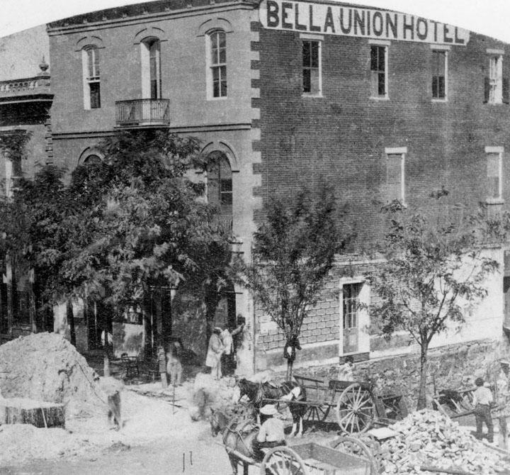
Note 2: The following photo is more apropos being from the correct period. The Bella Union Hotel had roots back to the 1830s. The Wikipedia page has some of the history. 

This is east of Temple and Main Streets. Temple runs up into Bunker Hill West. 

Remarks: Modified: 12/23/2025

12/23/2025 --


Thursday, November 13, 2025

Charlotte (Coffin) Gardner

TL;DR -- On FB, I saw an article that reminded us that the author had created a related blog which contains very good articles. On browsing, we ran into Charlotte (Coffin) Gardner. She kept a journal on her 3-year voyage with her husband and son. Along the line, she mentions New Englanad folks and natives as well keeps record of their progress along the continents to the Cape and back up. Names overlap our earlier research. So, we will recoup the interest level. 

---

An article today on Facebook got me to looking at the articles of Melissa Berry on her blog. Here is an example article in American-Archives. The topic is a wive who went on a three-year voyage with her husband from New England around Cape Horn and up to San Francisco and Washington State. 

These links point to pertinent material about Charlotte and to a Journal that she kept during the voyage. She is a descendant of John son of Thomas and Margaret. Her husband is a descendant of Richard, brother of John. 

One thing that is of interest would be to use Google's map to follow her on the voyage. The next link goes to a view of the western hemisphere with a location marked.  

There were many stops mentioned in the book. Here are three Wikipedia articles. We will have more. In addition, Charlotte marks her location on a regular basis as the above Google map shows. 

In the articles and in the blog, there are many names mentioned lots of which are familiar from our studies of New England with some being kin of various sorts. Too, we have a theme of the long reach of New England which our posts on Bunker Hill West which is in Downtown Los Angeles show. 

A few years ago, we did posts on the barque, Bostonian, that was owned by Hentry Gardner and his brother. In that material, we learned a little bit about the nautical ways after spending lots of time looking a movements across the middle of the vast area of the U.S. The Bostonian wrecked in 1850 along the Oregon coast. The pilot was noted as Capt. Boyling. 

Charlotte, in her blog, mentions Capt. Boyling which got our attention. So, as well as studying her Journal, we will pick up our study of the barque, Bostonian. Again, here are a few related postts. 

Several themes were mentioned here. What this represents is that the 250th has lots of open research pending. But, in general, here is no end to the study of  New England.    

Remarks: Modified: 11/13/2025

11/13/2025 --

Thursday, October 23, 2025

Siege of Boston, I


TL;DR -- We will do a series on the Siege in the next few months. It dragged on for almost a year. 

---

For those who have not heard of the 250th of the U.S., we are in the first year of the Revolution as it started in the Boston area in Spring of 1775. Usually, people talk of 1776, but that is for the signing of the Declaration of Independence in July which is when the 250th year will end and when we start the 251st year. 

Of the remembrance of a long war. It started before 1775. Then, Cornwallis surrendered in the fall of 1781. However, hostilities continued and the treaty was not signed until 1783. We have lots of material to cover, related to families personally. 

For this post, we will do a few looks at the Siege of Boston. Today, let's look at a few past posts on the subject. These are in order that they appeared in the blog with the year of posting noted. 
At this time, in late October, we have five months before the Siege ended. April was a long while ago. People were coping and organizing. 

Remarks: Modified: 10/23/2025

10/23/2025 - 


Friday, October 3, 2025

Bunker Hill West - 1873

TL;DR -- Today we saw an old photo of a sketch which shows part of Bunker Hill West in the 1870s. That's early enough to be before lots of the changes introduced over the long span of US history. The English culture took over in 1847 from that of New Spain. And so, the area has lots of offer with respect to our interest in the long reach of New England. 

-- 

Here we go with a post on LA, again. Yesterday, as we looked at New France and New Spain, we mentioned Bunker Hill West. In the early days, the hill overlooked bustling LA. Then, people built upon the hill. They tunneled under it to start to build on the other side. It was partly lowered starting in the 1960s. Now long after, the skyscrapers started to appear with the first one right by the Library which is about as old as the LA City Hall. 

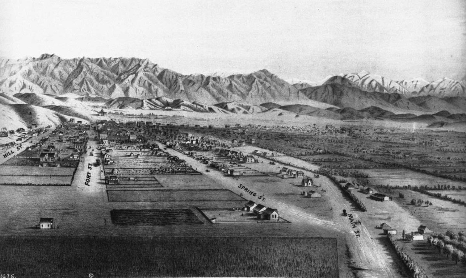
This pointer is to a search on Los Angeles within our blog. There may be Bunker Hill posts that did not come up on the list. In any case, the below photo which is courtesy of the Water and Power Organization of Los Angeles, CA is from a sketch near what is now 9th Street looking north. To orient the view, the well-known City Hall is between Spring and Main Streets (shown converging here) eight blocks north above 1st Street. 

To the middle below the foothills is where one would find The Cathedral of the Angeles, not built yet. The train station is north of that. 

Of interest today are the hills on the left. If one follows the Fort Street line (left of Spring Street) up toward the hills to north, there is a building standing above the city. That was Fort Moore. Going to the left, one can see parts of Bunker Hill West. 

Prior posts had some information about the history of development of the hill. Today, we wanted to show a view indicating that there was a hill of size. According to Wikipedia, the elevation was up to 200 feet above Los Angeles. Naturally, there are higher hills including the massive 14k-foot  mountain within a morning's drive seen on the upper right. 

The Bunker Hill represents history, pre-US and post the events of 250 years ago. In this area, the culture changed several times in a manner that is representative of the changes in the US. The current stature of Bunker Hill is obvious in the photos of LA. The majority of the skyscrapers have their footing on the scraped down and leveled heights of the hill. 

---

Caption of the photo: (ca. 1873)* – Panoramic sketch looking north toward downtown Los Angeles showing mostly undeveloped land.  At lower-right can be seen the junction of Main and Spring streets at a point where 9th Street will one day intersect.  Hill Street and Fort Street (later Broadway) are on the left.  The Verdugo Hills and snow-capped San Gabriel Mountains can be seen in the distance. Photo of a lithograph, courtesy of the California Historical Society. 


DTLA, 1873 

We are fortunate to have original photos, sketches, and paintings of the area. One hopes that these photos with provenance continue to be available in the age of mimic and copy in a manner that does not preserve the truth of the matter. 

But, that's a technology matter to be discussed further with an actionable focus. 

Remarks: Modified: 12/23/2025

10/11/2025 - Water and Power has a whole page of photos from Bunker Hill West from the 1930s onward, including many areas compared with photos from then and now. 

12/23/2025 -- More on the Butterfield stage as representing the U.S. government's concern for handling Overland Mail. There has been lots of research about the trail from St. Louis MO to San Francisco CA. 

Thursday, October 2, 2025

New France

TL;DR -- Nutfield Genealogy motivated this post with their post. Amazing maps has been in our sight for a long while. The one we saw today is about New France which has not had the attention that is needed. So, we correct that. 

---

When we started, our focus was New England. Then, we got into New Spain due to the California influence. We mentioned New France and probably ought to have looked further since we ran into it many times. One theme/meme that will continue is the long reach of New England. Also, all things Gardner is on the plate. Technology? What happened in 2025? AI is everywhere with mature voices with mathematical knowledge finally weighing. We'll take part in that discussion and the followup work. Another theme? The 250th U.S. as represented by D.A.R./S.A.R. and those of the other sides (loyalists, for example). 

Lots and lots of things to do, but here is a list of subjects which suggest future work.  

  • Using Cape Ann, we learned about the commercial influence of the Dorchester Company. There seemed to be agreement about the events such as the 1623 overwintering, the 1624 arrival of the settlers, John Endicott's arrival, and then John Winthrop who disliked Salem and sailed off to Boston. In 2014, we found records in Dorset, UK. In 2023, a researcher went through all of the known records to find Gardner references. Pending is going through that and posing means to get the story in line with what we know and can know. See, Why is 2024 quiet
  • President Jefferson dealt with Spain with regard to the Louisiana Territory. We can use Missouri as the focus for several reasons. Our research was focused in the middle of the country, with St. Louis being somewhat of a gateway, though there was movement both along the north and the south. Speaking of the south, regular coach traffic occurred between St. Louis and San Francisco
  • We have to mention that the coach that ran across lower Arizona into California stopped in Los Angeles in the area now known as DTLA. We found out that a hill had been named after the battle site in Boston, Bunker Hill, which battle was part of the period of over a year noted as the Siege of Boston. Named Bunker Hill West, the area now hosts the skyscrapers associated with the LA skyline. Those bringing in the traffic from St. Louis and points east were of New England. That route met up with traffic from the lower part of Texas. And, in LA, there was serious New England influence. But, New Spain, too, was there earlier, leaving many place names of Spanish origin. 
  • We looked at rivers, extensively which brings up a notion (below). Gardner River got attention a few years ago. But, the Ohio, Missouri and Mississippi Rivers will be featured with respect to travel to and in the central and west parts of the U.S. 

Today, we saw a share by another blog (Nutfield Genealogy) that got our attention. It showed the extent of New France which is far beyond what we consider when discussing the French-Indian affair or the Revolutionary War. This map comes from Amazing Maps which can be accessed through various social media. Using FB (Meta), one can access this map. 

We had written several years ago about the French being down in the Arkansas area at the same time that Thomas Gardner and others were founding New England which was a little bit of land shown in grey on the right. The blue shows the wanderings of the French. One tales recalls that a crew had crossed the Great Lakes to the area of nowadays Wisconsin, portaged down to a river than ran into the Mississippi. When they got to where the Arkansas River (out of the Rockies) met the Mississippi, the Frenchmen started to see the Native Americans with artifacts from Spain. They were not far from nowadays New Orleans at that time. 

Too, up in the northwest, later, there was disagreement amongst the travelers then, trappers and mountain men, about where the U.S. and Canada split. This was not settled until the 1840s. Those representing Canada's rights were of New France. 

Remarks: Modified: 10/02/2025

10/02/2025 - 

Sunday, August 31, 2025

Map and territory

TL;DR -- Concrete isn't something thought about with computers, except we know of one software package that used the name. But, we need to use concrete language and examples to hone intelligent approaches toward something that represents maturity. How to do that? We expect that New England and the US over time have plenty of examples. Real people doing real thngs. That will continue to be the case even as we see technology continue to expand and play havoc with stability, if we  let it. 

--

Last year, we had a post (Three weeks) that looked at early travel across pieces of the U.S. This was in the vein of our recent report on Knox's movement of tons of cannons from Fort Ticonderoga to Boston. His crew had to go two directions across New York and Massachusetts during winter months. And, this feat was accomplished during the time of the Siege of Boston which was part of the American Revolution that occurred 250 years ago. 

So, we are dealing with historic events which are of time and space. As a reminder, 100 years ago or so, Albert Einstein proposed a model of space and time that was confirmed and has been at the core of our model of the physical world. For the most part, that focus deals with cosmology though the science of physics has its quantum theory that has to deal with Einstein's equations of relativity. We can ignore all of the technical details and focus on some local events (explained below). 

The considerations technically handled by Einstein apply across the board which is part of the complexity of life. Another bit of adjustment, though, came with computing. We have written a lot about that and will continue. Of late (the past three years), lots and lots of attention (perhaps, too much) has been put upon GenAI/LLM. "AI" has been around since the '50s. The "Gen" part is 21st Century as is "LLM" which is the latest approach to handling language for input, control of the computer, and specifying output. 

For instance, there are ChatGPT (OpenAI) and Gemini (Google) and many others. We have sampled a few of these but kept it brief. Why? The approach is heavily dependent upon using resources by design. This did not have to be. There have been more efficient methods demonstrated. From our experience, there was not much new offered by this approach as we will see, eventually. 

Right now, consider this post and its graphics: Deadly consequences. In this post, there is an appealing image with respect to our work. The first reaction concerns what can be learned. Did someone do new research and find a gem? Nope, in looking at the image with a critical eye, things pop out. The raft is wrong. Some of the horses are badly modeled. How many errors are there? 

The point is that with this type of bad output, people can be fooled. On FB, one of the groups dealing with early LA (where our interest is DTLA and its Bunker Hill neighborhood) has had many images that were obviously fake but not identified as such. One rule needed? Anything done by algorithm needs to be identified with respect to what we need for verifying provenance. 

Note: Bunker Hill west in DTLA was named for the Bostonian mound of much fame. But, our interest is in the long reach of New England where LA provides us lots of examples. We like Bunker Hill since from the time of New Spain/Mexico to now, New England had a heavy influence. Several generations of buildings are represented in this area that pertain to a proper study of the history of the U.S. 

So, now to the point of the post. This image I put together for the "Three weeks" post. The gist of the matter is that a group traveling along the Sante Fe trail across Kansas would have taken three weeks to go from Indpendence MO to Fort Larnerd KS with the grind of daily travel.


Now, we will discuss each of the pieces of this image in terms of map and territory. Nowadays, advanced computing likes to demonstrate its prowess in modeling nature. Then, if that model is good, the computer can control something in the world. Take autopilot. This software can take off and land a plane. Now remember, involved is a lot more involved with this. We use "map" for the digital model in the computer and "territory" applies to the outside world. So, a control item on the wing of a plane would have means to feed back to the computer about its status and then take instructions from the computer to make some movement, say for a turn. 
 
The recent visible demonstration of this is the auto-car that can drive itself. Some do not even have a steering wheel. In the case that human input is needed, it can be handled by interfaces common with computer games, such as joy sticks. 

There is something called the map-territory problem (Wikipedia; John's Truth Engineering site). In the auto-car, too much reliance on interpolation between points on the computer could result in it not knowing the proper position of the car. There are many ways to discuss this, but, in general, when people are dealing with "smart" systems, it is very easy to forget where some data originates. Handling critical conditions in the world would put more emphasis on the local condition. But, what if a person is not there or incapitated? 

That is why the discussion is always in scope. Fortunately, most software development processes run through these types of things and determine how to handle, before the fact. People in the world do this but also have to think on their feet. The computer cannot do that, in general, despite the claims that we hear. Some reports might come from someone who does not know that they're engaging in a fallacy. It's not so much a matter of "truth" as it is of verification and all that such entails. 

John also has a site that discusses complex systems and the computational problems faced with these. It's called "7 'oops 7" and considers map-territory from a different angle which relates to abstraction and generalization. Frankly, this site pertains to GenAI/LLM's problems more than truth engineering given the present situation.  

---

Now, let's look at the top, middle and botttom of the image. All images are from Google maps with annotations. 
  • Top - The blue line represents a current bit of highways from the Kansas City area to Fort Larnerd. The post on KC provides another map and details This follows the Sante Fe Trail which went from the KC area to Sante Fe NM and was followed by thousands of wagon trains going in both directions. Too, the travelers could have come from the east coast or from overseas. Many came though St. Louis MO. This blue line represent three weeks of hard, daily travel. Even at this point, one still had hundreds of miles to go to get to Santa Fe. The modern trip planner says that one might expect to spend about 5 hours doing this journey. 
    • The topic? In this time, there was no map beyond hand-written sketches. There were models. The guides and wagon masters knew the route. Choices had to be made during the travel. As we know, weather changes and can do so drastically. Many water ways had to be forded. Along part of some trails, there were ferries that were basically flat barges that could carry weight across the water. 
    • With respect to territory, as well, energy was expended by people and their animals to do the traveling. After hours of travel, one had to set up camp for the night, feed ones self, handle maintenance task related to the living or the inanimate. Most wagon trains had guides and hunters who could acquire game for food if such was available. But, in those hundreds of miles along the blue line, the territory changed drastically. In terms of gear, wheels broke. One thing about crossing a water way, many times there was a need to tear the wagon down, cross the waters (bringing the gear in the wagon - several trips) and then put things back together in order to continue. One modern term related to this is logistics. We see semis running down the road touting their expertise and efficiency.  
  • Bottom - The blue line this time shows the trip from St. Louis MO to San Francisco CA. Quite a jaunt? The modern estimate is 39 hours as it is mostly on higher speed Interstates. But, this was also several weeks of travel covering a larger territory as the vehicles were stage coaches. We will be looking further at this line as there were several others. But, this one was three weeks from St Louis to DTLA. We mentioned Bunker Hill west above. The stage line came into LA in that area, where people could tidy themselves and such. Then, the trip continued up the coast to SF. At that point, there was then a return trip covering the same territory. 
  • Middle - The two images set up the condition of three weeks of constant travel across the US. The slower on never left one State. The faster one went from the middle of the country to the coast. That's pointed out with the red lines on the left. The trail to Fort Larnerd was three weeks of grind and danger. The STL to LA to SF trip was no joke either. We will go into that later. Passengers bounced on hard springs, the carriage was open to the weather (unlike the modern car), and people had to keep hold of their belongings which could go flying out the window. The horses and drivers were doing the work. 
    • Again, the territory reigns here. The drivers need to know their way which is a map issue. In many cases, the coaches even traveled at night as the trails were marked. Yet, there was nothing like modern pavement. Too, even KS has hills, creeks, and rivers. This is more pronounced with the western route across the country which had to pass through mountain passes which are more benign than one would have found in CO (which even today has many areas closed over the winter season). 
    • We added in the black line which crosses the waters back to the source of New England's population at the time of its start. We can speak of two ways to go. A cruise line of a modern type can travel that route in a week. Mind you, back in the 1600s, this could be months even if only a few generally. But, nowadays, in three weeks, one could take three of these trips. Granted, modern travel brings in more interesting issues of map-territory. Mainly, the cabin crew would know where the ship was and its heading. Passengers would have to know the "lay of the land" of the ship in order to get around and enjoy the cruise.  
This was to emphasize the reality of the ordeals of our ancestors which we can easily forget about with the ease of life brought by technology. But again, someone keeps those technical efficiencies going. That's a map-territory issue, as well. The purpose for this post is to explain why we are using the TGS, Inc. framework to discuss technology and its issues. Well, the map-territory mismatches are prime examples and can be used to explain how problems arise. 

Take vibe coding or prompt engineering. The human has the maps (knowledge) and, for the most part, the territory. Robotics with change this dynamic but has its own issues which we'll get to. The interchange by language or other input is part of the system. But, the computer has no notion of the territory in other than the "map" sense, using the word loosely. In fact, with respect to coding, there are issues of how pulling together fragments from the past being coupled with tests as the evaluation scheme can do more than a gross approximation. 

Frankly, I see this with increasing frequency as GenAI/LLM's influence grows. Take website. They look good. The semantics is way off, to say the least. The hard partt? There is no one to talk to about this and the interchange with people has been cut off with bots being asked to take over. I see it operationally, as well, as logic is not quite up to snuff as it was released using other than mature and quality-fluent methods. 

One final bit would be to add in aerospace to the middle image. Where the cruise takes days, a modern jet of capacity can traverse the spanse in part of a day. One can expect that a good airplane could go one way in the morning and return in the afternoon (notice we're talking NY to London which can range around 7 to 8 hours plus or minus two or three hours - fuzzy math - Zadeh's, so being serious). Then consider the map-territory issues of flying which again range widely with respect to the crew and the passengers. 

This example uses something real in the context of Kant's emphasis on experience for knowing. Human life is full of real territory examples and the map examples prior to GenAI//LLM. The computer has been complicating things with that accelerating in the past three years. Concrete examples are going to be important. Meaning, in part, that some of our work now will be to explain errors that crop up and to use examples to explain. 

That is, appealing to "black box" issues cannot be taken at face value. That is a copout. I see lots of discussion now about the mathematics of GenAI/LLM with some of it ex post facto. That means that people have taken the initiative to build an analyzer to do comparative analysis after the fact. Some of this is very encouraging as this could have been done before.

You will hear me argue that the past three years would not have happened had the "knowledge" processing work been allowed to continue. And, my example will be KBE and its contributions to engineering. At the same time, there were many other examples. These, incorporated into the model framework, will settle down that which is fueling the hype so that we can get real work done. 

Remarks: Modified: 08/31/2025

08/31/2025 -


Sunday, June 22, 2025

Bunker Hill, II

TL;DR -- The Siege of Boston continues until March of next year. This past week, there was an effort by the British to dislodge the patriots (or provincials as known in London) which didn't work. We will have to look at what the next nine months entailed for both sides, in MA and elsewhere. Speaking of which, "Bunker Hill" has been used a lot in naming over the 250 years. We compare the MA one with that area in DTLA with the name, again. But, will look at some others, ,worldwide. 

--

Right now, we are in the period that was associated with the Battle of Bunker Hill with a main skirmish happening on 17 Jun 1775 with the first piece of the action happening at the locale of Lexington & Concord in Apr of 1775. Bunker Hill Day is a regular holiday in Boston on Jun 17th. 

At this time, in 1775, the British were still surrounded. The Siege of Boston continued. The next day of commeration will be the Evacuation of Boston that happened on 17 Mar 1776. 

As we mentioned, the Massachusetts Magazine had an article on the troops that participated in this Siege with some information about the officers. There was an article in every issue, 1911 to 1918. 

And so, we will look at events and people over the coming years as the 250th lookback unfolds. 

----

May we change gears? Bunker Hill is a little over 100 feet high and is in the Charlestown neighborhood. There is a monument for the event on Breed's Hill which has a lower elevation and where most of the activity took place.

At the time of the Battle, the British owned the waters as Boston was across the Charles River from where the Battle took place. The whole affair is quite strongly resident in the American mind. In fact, Bunker Hill has been used as a name in many places. We will look again at Bunker Hill West which is in Los Angeles and about which we have had several posts. Today, we look at the lay of the land. 

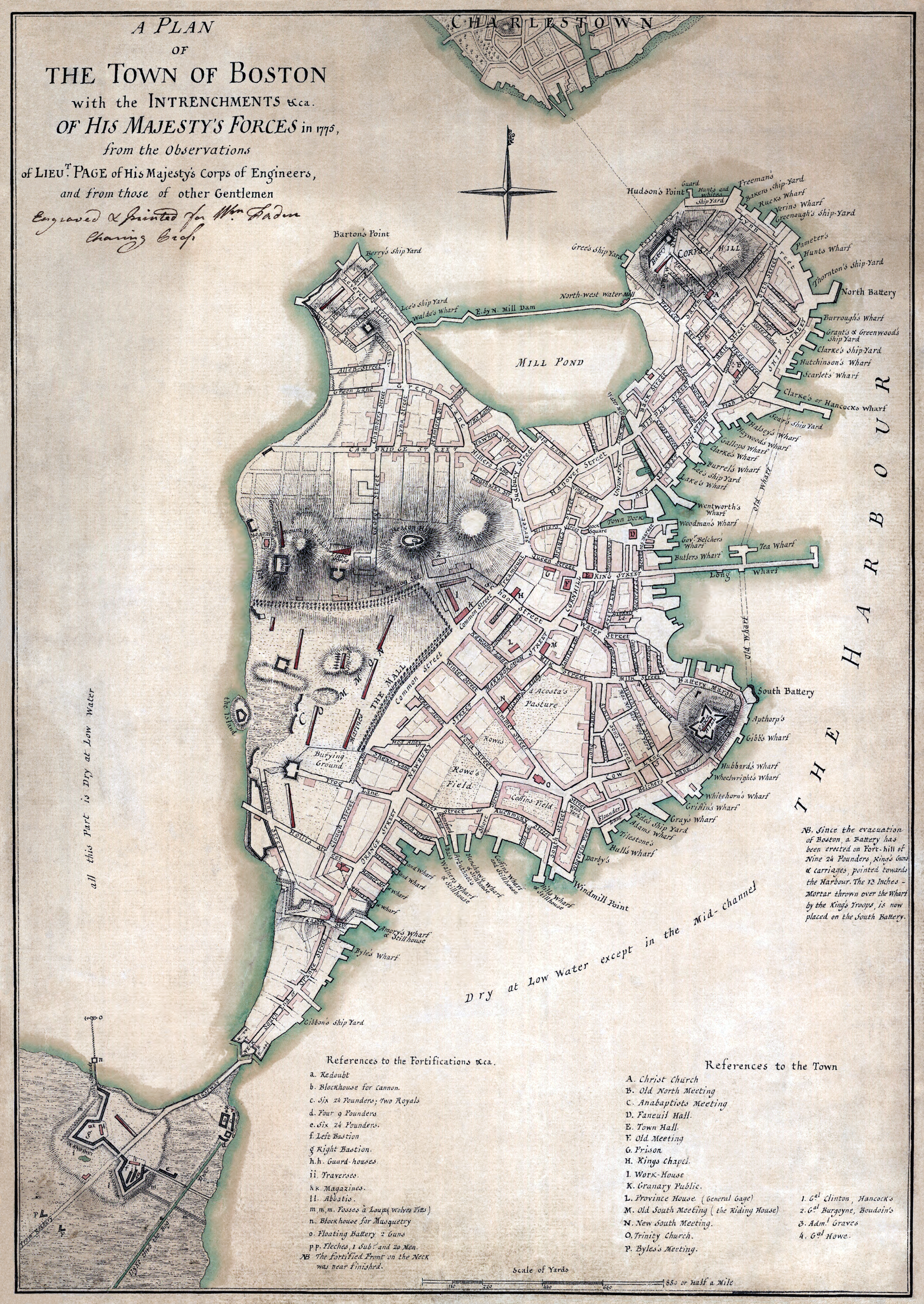
But first, here is a London map of the situation in 1775. 

Printed Aug 1775, London

Before transitioning to the west coast, we have to mention the last surviving veteran of the incident: Ralph Farnham (1756-1860). He is of the upper part of Massachusetts now known as Maine and is cuz as are many. We will look at him, again, as the whole of the Maine experience needs more attention partly due to the case of the southern entity, Boston, was more prevalent in historical accountings. 

---
 
Now, Bunker Hill West? The name has been used in many places: the Wikipedia list. Notice that Los Angeles is on the top of the list. Our interest was first brought to the area as this is where the stage coach route from St. Louis arrived after an arduous trip down into Texas, across the souther border (wandering into Mexico), and then ending in Los Angeles. That was not the terminus, as with some refreshment of resources, the stage line then carried passengers and freight up to San Francisco. Where, the process started again on the way back to St. Louis. 

Mind you, folks, there are several things to consider: logistics (compared to the Pony Express, this was much more of an intricate maneuver; we are talking pre-Civil War however some of the western States had been defined (such as Missouri in 1820 - added along with Maine to balance the north-south  issues; in terms of Bunker Hill in DTLA (Downtown Los Angeles), though, the terrain was entirely different as we will be pointing out. 

The lowest point in DTLA was about 59 feet. The hightest was the hills to the west with Bunker Hill (BHW) topping 350 feet. DTLA is many miles from the ocean. In terms of survival, being in a sheltered, inland cove with fresh water from the mountains would be more appealing than the environment now associated with being encrusted by salty waters. 

In the latter part of last century (post the 1950s), there was an effort to knock BHW down which seems to have been successful. They flattened the basis for the high rises that rose and that are now photogenic against the background of Nature's display of mountains. 

Here is an example. I marked three things. 1) On the right, the line points to where City Hall pokes its head up proudly. This 1937 building was the limit for heights until later in the 1900s. We can be more specific. There are early photos from Bunker Hill showing the top of the spire of the City Hall. 

Now is the time to mention one other thing. In the center, the tannish (round) building behind the white (square) one was the first building to penetrate the old limit. The developers used the opportunity of the LA Library having experienced arson and selling its airspace to get funds to recover as a means to start the trend that gave us the high-rise look. 


So, speaking of the Central Library, they recovered physically and bought replacement books. But, there was another instance of arson later. To me, on any of these photos, I look for the bank building and figure out where the library is nestled (having spent many hours there; across the street; the base of the bank building is on higher ground along the elevation of BHW). 

2) and 3) These have to do with old DTLA from the time of New Spain onward. In the middle, the text says that if we jump (or fly like superman) over the buildings we would find the Old Plaza Church. Several of our posts have photos of this building from various time periods. Yes, it was there when Butterfield came in with his stage line. In terms of the beauty of DTLA, the Train Station which is a remarkable example of SoCal architecture is across the street. 

So, now we can consider another church. Not far from the Old Plaza Church and the City Hall is the structure that was St. Vibiana, a Catholic cathedral. That old building dates from the 1870s which is new from the west coast view point (reminder for those looking from the east). An earthquake caused some damage but not enough to destroy the building. It now is an event center of some note. 

The cathedral was moved to the left side of the photo where US 101 and the 10s intersect. We can figure out the lingo, but the area has been visited by tourists with many photos extant. This view shows the extent of the high-rise area. And, the larger buildings are clustered there at BHW. 

---

There are early photos (1870s) showing that people started to try to tunnel from the getgo. Several tunnels were completed with many still operational. As well, there were steps put up for people having to go up to the buildings on the BHW or over to the other side. And, the Angel Flight configuration of a rail car exploited the arrival of electrical power. Fortunately, through many periods of reconfiguration such as the scraping down the elevation, people saved the old mechanism which is now more of a tourist event rather than operational. 
 
---

What's next for looking at the namesakes of Bunker Hill? 

Remarks: Modified: 12/23/2025

12/23/2025 -- More on the Butterfield stage as representing the U.S. government's concern for handling Overland Mail. There has been lots of research about the trail from St. Louis MO to San Francisco CA. 

Saturday, May 31, 2025

2021, time of the pandemic, I

TL;DR -- The pandemic started. Life was restricted. We did local things. And, worked on the web/cloud in various modes. 2021 culminated in the most posts that we had since our start with topics that cover a very wide range. Knowing the U.S. and its history is one motivation. 

---

Part 1 of 2 (Part 2). 

In 2020, we found out about the coming restrictions after being in one of the cities where the disease was reported and said to be related to someone returning from overseas. Then, we endured the restrictive period with access to the outdoors as well keeping busy with "web/cloud" activity along several lines of research. 

Our focus on technology was one line of study for the Thomas Gardner Society, Inc. The next year, 2021, had the most, 105, posts published since the start of our work. Below, we provide a list by month of the titles of the posts. As can be noted, the topics varied greatly which we will comment on below. 

First, here is a list of the topics for the first six months. 

A subject of lots of focus was the travel of folks from the east to the west through the middle. Of course, looking further at the west coast got our attention to New Spain. The rivers of the interior were of particular interest as the Missouri River starts out in the far western mountains, closer to the Pacific than to the Mississippi River which it joins at St. Louis. Not far from there, the Ohio River comes in from the distant east having started in Pennsylvania. But, there is more. The Arkansas is a little south of that area and had eastern visitors from (what became) Canada early on. That exploratory group from New France headed back up north when they started to see evidence of New Spain. 

Naturally, looking at the Missouri, we had to consider other rivers near its origin, such as the Gardner River (Yellowstone, plus) which flooded recently. We looked at several tales related to the area, including that which motivated the movie, The Revenant. Our earlier focus was there, namely Jedediah Strong Smith. 

Going back up north from the Arkansas on the Mississippi, we get to the Wisconsin River that joined above St. Louis. The French group had traveled over the Great Lakes to the mouth of the Fox River. About one-half way to the Mississippi River, there was a portage which was brief, comparatively, being only two miles or so between the Fox and the Wisconsin (on the western part of the trip).  

In work related to family history and genealogies, we decided that there was a frontier century which is observant now with respect to missing documents. St. Louis was a hub of movement. The U.S.Government was early there with land management. Think of the time of Daniel Boone who was out, with his family, to western  Missouri (Kansas City area) as a settler. But, he also ventured further out past the Rockies. Other federal activity was military: Fort Larned, KS

Speaking of which, there was a stage line that ran from St. Louis to San Francisco. Not across the middle of the country. No, this one went south and joined regular movement from Texas to Los Angeles through Tucson in Arizona. In Los Angeles, the activity was in the Bunker Hill West area which has a long history that we have written about (Mirror building). Of course, then we had to look at mail and freight. Too, newspapers were delivered. 

We didn't forget the sea as the California cities were largely populated by ship in the beginning. Once the internal trails were established there was a huge flow across the middle. The Pony Express carried mail and small material. Several stage lines carried people and freight. We looked closely at the Butterfield Express. 

Why? All of this activity was seriously associated with, or driven by, New England influences. In fact, Kansas was a Massachusetts project with its University being founded by a group that included women who came to set up a free State. We have a lot more to write of that. 

Everywhere in the unmapped territory, we had trappers. Some were even venturing down from New France and Canada. Then, the next phase was trader as folks moved across the country, many of them stopping at locations that exist today having been started by the pioneers. 

Along came the railroads which have a special interest due to family involvement. That facilitated one of the major memes of the west, driving cattle to the markets. So, rancher/farmer would be the next phase continuing today, in the flyover country (had to menton that - it's from an earlier post). 

Next up, we'll look at the second half of 2021 in terms of posts. These posts cover the U.S. and its history. Interspersed are posts on technology, which increased with the release of OpenAI's GenAI/LLM

Remarks: Modified: 06/03/2025

06/03/2025 - Clarify that the journey on the Fox to the Mississippi starts at the Great Lakes and runs upstream in IL to a point where the Fox is close enough to the Wisconsin for a reasonable portage. The Wisconsin then runs down, and connects, to the Mississippi. In the reverse, the journey goes up the Wisconsin to the portage and down the Fox to the Great Lakes. Modern technology has improved that route with locks allowing the height changes to be managed. 


Sunday, May 18, 2025

Bunker Hill, I

TL;DR -- We're in the time of the Siege of Boston with the Bunker Hill incident on the horizon. But, the Siege went on until March of 1776. So, we have a few more items to look at prior to the hubbub of the Declaration of Independence whose inspiration was, in part, brought by kin from almost 100 years prior.  

---

Siege of Boston

The first thing to remember is that we are at the 250th of the Siege of Boston. Earlier, we looked at an event that led up to this: Lexington and Concord. This start of the turmoil on April 19th attracted support of able-bodied men in the area, except for Salem troops under the command of Col. Pickering (Where was Salem?).  

In our research, we ran into the battle of Bunker Hill (17 Jun 1775) early on through reference to Col. Thomas Gardner who was killed in that conflict. His 25th Continental Regiment was involved in several engagements. 

This brings up Dr. Gardner's look at the Regimental history through a series of articles that appeared in each of the issues of The Massachusetts Magazine. In the first article, he discusses the Siege of Boston and notes that the revolutionaries were not solely rebels. Many officers had served the Crown in early conflicts. 

The Siege was almost a year, going to March of 1776. We have time to look further with respect to our themes. 

---

Los Angeles (LA) of California (CA) has a neighborhood that is called Bunker Hill west. We have had several posts on the area which represents the history of LA from the time of Spanish rule to the current age of skyscrapers that have populated Bunker Hill West area. Early English involvement the area was in the 1830s. After that, many New Englanders showed up in the area. We have been researching this influx and have reported on some families. 

A stage line came into LA from Arizona (AZ) that was part of a freight/mail business with an eastern terminal at St Louis of Missouri (MO). Pre-Civil-War activity on the line followed a tight schedule and was supported by stops along the way through several current States, including Texas (TX). The area in LA where the line had their stop and supporting businesses, such as those that provided horses, stage maintenance, and more, was at the bottom of Bunker Hill West. 

The Butterfield Express, and many other Express companies, were New England in origin. Of interest is that many of these are still in existence. 

---

The Revolutionary War started in 1776 and went until 1783. So, we will have several years to look at this history in all aspects including families and their genealogies. So, let's remember Rev. John Wise of Ipswich, MA who was seen, almost 100 years later, as the inspiration for the document normally associated with the War, the Declaration of Independence. The Col. Gardner mentioned above was related to Rev. John through their Gardner lineage. Both are kin. 
 
Remarks: Modified: 12/13/2025

12/13/2025 - More on Bunker Hill, per usual. 

Saturday, April 26, 2025

Bunker Hill of early LA

TL;DR -- DTLA is known for its forest of scrapers clustered on or near Bunker Hill West which is an example of the influence of New England. The rise of fakery, such as we see with GenAI/LLM, has put more importance on existing photo caches that carry historic value. So, we show some early scenes from LA which underwent several transformations in a little over 100 years. But, using the Bunker Hill area, we can pinpoint a few instances that are of value to history. 

---

In our research of the expansion of the U.S. during the times of COVID, we referenced the commercial aspects of overland travel several times. That was mainly to carry mail, commerce and people. Of the activity that we looked at, we always found New England connections. 
  • St Louis MO to San Francisco CA - this was pre-Civil War. Our post showed the schedule and the route. From that research, we looked at several things including the people involved, early LA, the route itself, and more. 
One of those connections was that in hilly Los Angeles, the downtown itself early on nestled under hills. One of these was given the name of Bunker Hill West and have had many posts. Old L.A. and the U.S. is an example. In that posts, one of the images was a very early photo which was of the area where the Overland Stage came in. Times Mirror (old employer of John) came to be in that area, too. There are other connections related to New England families who came out and developed the area. 

These photos are all from the 1860s and shows that phase of the development of LA. Bunker Hill West? It is where all of those skyscrapers now sit, upon a hilly area that was leveled. In the period that we will look at, the hills were first tunneled under so that there could be regular traffic (days of horse power, but commerce was increasing as was the population). 

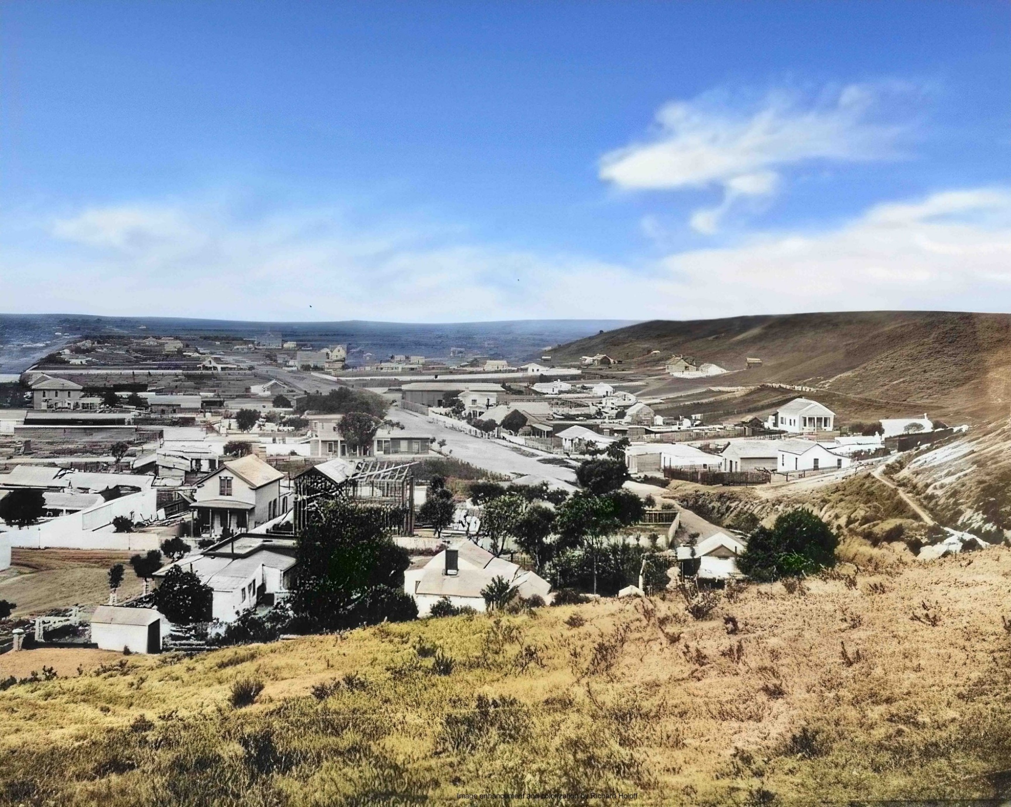
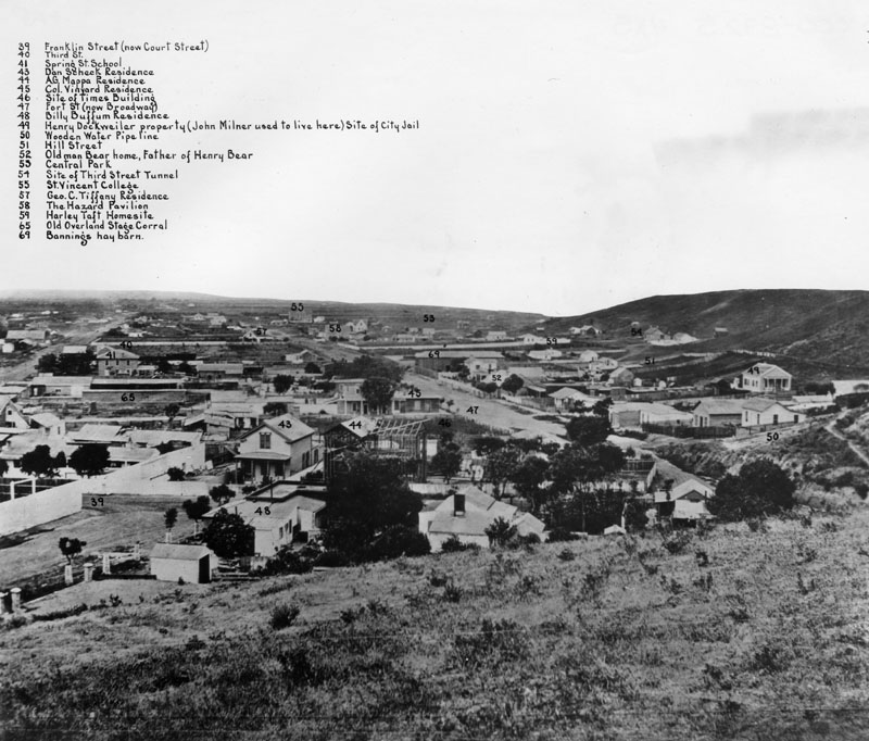
Today, we saw a colorized copy of a photo provided in the "Old L.A. and the U.S." post. The photo is next. All of the subsequent photos are from the same source (Water and Power Associates) which we will do another post on, especially now that we have GenAI/LLM trashing the internet. 

Taken from Poundcake Hill
On the right, we see part of Bunker hill
1868 - colorized

Now, this photo has the legend of these building which are numbered. "65" labels where the Overland activity took place. This area was a stopover both ways, the St. Louis route went to San Francisco and back. 


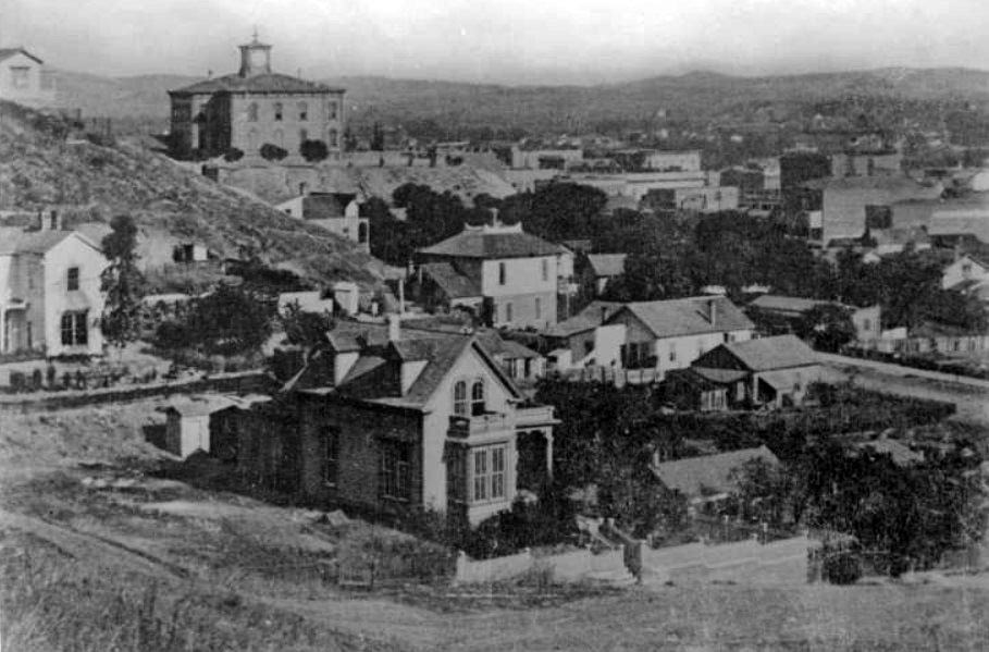
The following photo is of the same area, but it is from a position on Bunker Hill West. From Poundcake, one would have gone to the right to Bunker Hill and then taken a few steps along the hill. Again, there is a legend. 


Now, the next photo shows the same area, but off the hill, in the 1870s. The first high school had been built which sat upon Poundcake hill.  

High school (with the tower)
on Poundcake Hill
1878

In our next posts, we will look at the end of the Mexican era which corresponds with the arrival of Jedediah Strong Smith. New Spain was in the region long before this time. The earliest involvment of New England can be associated with the Bella Union Hotel. An adobe structure was built in 1832 and was the residence of the New Englander. The building was also an office for the Mexican government. By the time of the Overland Stage, it had built up to be used for office work. 

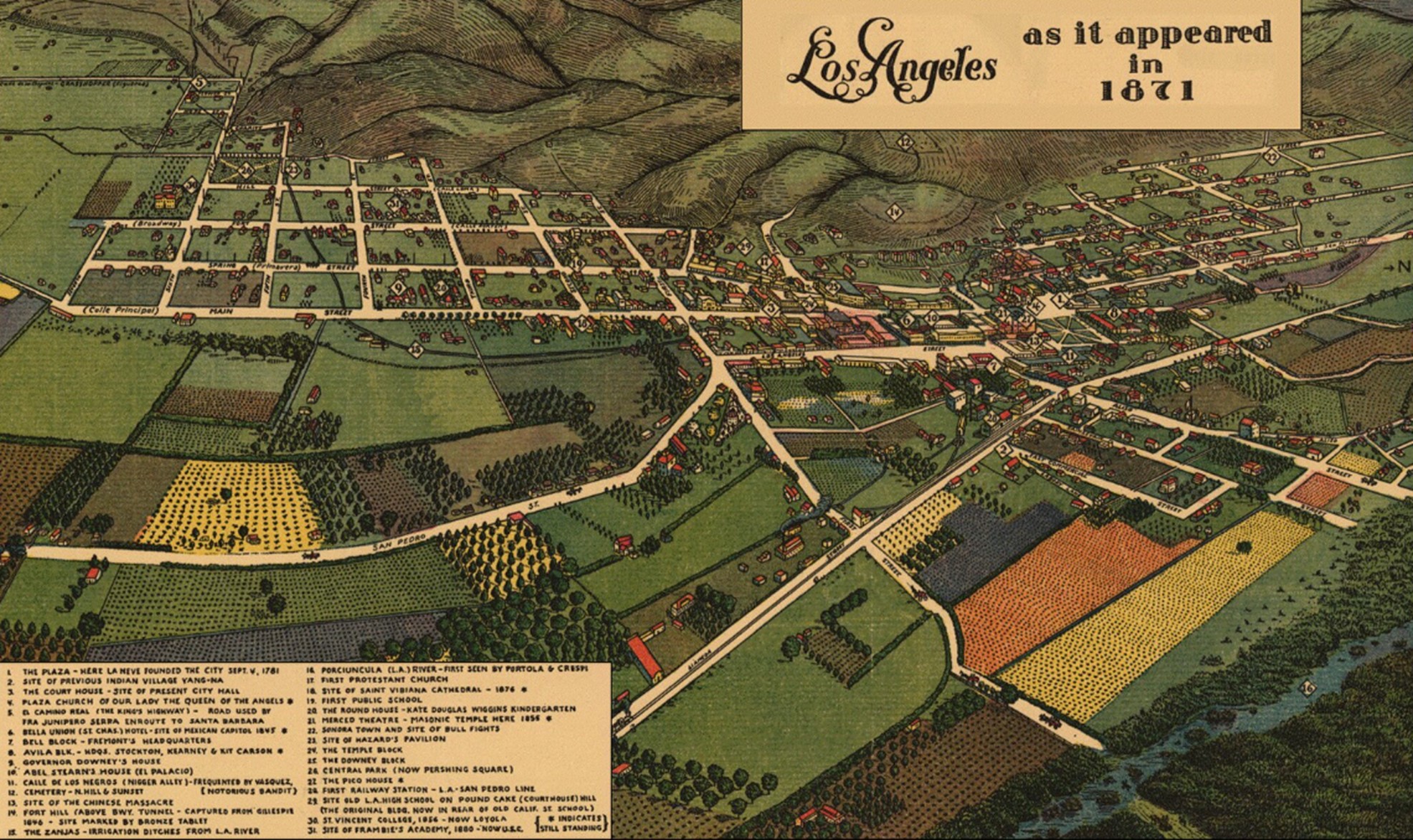
We have mentioned the hotel and offer this map from 1871. Being an illustration, it doesn't show the contours and limits of Bunker Hill West, but one can see how LA was in a valley and had a agriculture focus. Streets were established early; this scene shows Main and Spring as they come in from the countryside and meet where the LA City Hall now stands (built in the 1930s). 


Both St. Vibriana's and the Old Plaza Church are prominent by this time. Where the roads end at the green hills (idealized presentation), now we see the DTLA scrapers nestled along several blocks as they sit on reduced hills.That accomplishment, itself, is worth some attention as well as the attempts at bringing water into the area. 

But, the main focus will be the transitions through time by culture and the artifacts (buildings). LA is unique in having such speed of alteration. 

Remarks: Modified: 12/23/2025

12/23/2025 -- More on the Butterfield stage as representing the U.S. government's concern for handling Overland Mail. There has been lots of research about the trail from St. Louis MO to San Francisco CA. 


Monday, March 17, 2025

Independence and Kansas City

TL;DR -- Trails were and still are in the sense of leaving tracks on the landscape (several places along the Santa Fe and Oregon Trails. And, now the Interstate Highway system with all of the national, state, and local roads. And, going further, even now dirt roads as tracks. Sometimes converted railroad tracks. 

--

With all that is going on in the world, and in the U.S., it is time to look back at the past. In 2020, we got the opportunity to spend time looking at the interior of the country which is huge. In terms of time, we had a frontier century (post has copy of photo of Lawrence, KS by Gardner). We got to learn about the trails and the cities that cropped up (theme of this post). We determined that there was a lost generation or two (Boone was real; officer in the US Revolution; Longhunter; traipser of land (all the way past KC with time spent in western MO) in the movement that came to fore as we looked at the upcoming 250th of the US under the auspices of the Daughters of the American Revolution. Doing applications for some requires lots of additional work. 

Before 2020, we had looked at the trails and those earlier like Jedediah Strong Smith. Gardner, KS was seen as a hub of traffic and activity. Also, we had looked at both land and sea traffic to the left coast (Old LA and the US - as in Los Angeles, CA - in particular, Bunker Hill West, where the culture went back to New Spain and then through several cultural shifts to the current canyons of high rises).

---

Now, to the theme. We saw a video of a talk about the trails and how they came into Kansas City and left. It was of the first part of which there will be another. We mentioned Gardner, KS where 3 Trails split. The Oregon went over the Wakarusa River into the Lawrence area and then up to Nebraska. Even in that trek, the rigors of getting people and goods across the land was obvious, especially trying to get over waterways which were boons and banes (mostly the latter for many). 

The talk: How Independence & Kansas City Became Trailheads for the Oregon/California/Santa Fe Trails, Part 1. The following image came from the talk. On the map (a modern map showing some roads), Independence, MO (where Pres. Truman came from) is on the upper right. Gardner, KS is on the lower left. 

Indepencence, MO
Gardner, KS

In the top middle, notice Wesport which is on the Missouri River. After a little bit of time, impatient travelers (read, young men off to the coast with gold fever) realized that they could take the river up past St. Joseph, MO (famous for the Pony Express) and then a little further north, they could head west in Nebraska. While doing that, they would meet travelers coming up from Gardner, KS. But, they would have cut several days off the journey. 

OCTA, sponsors of the research and talk

---

Notice that this is about the early times. The railroad came into play after the Civil War. 

Generations? By this time, say before the Civil War, we were to the 8th generation from the start of New England. The Revolution was mostly of the 5th generation

Cultures? As we have noted, there were the News: Spain; France; England; Sweden; ... The left coast allows us to look at the first; Quebec, Canada is representative of the second; we had both a North and and a South for the third; and so forth. 

---

KC? MO and KS. Missouri and Kansas. We need to look at the area a little further. It's known for beef and barbeque. Well, cattle came up from TX to be shipped east to the hungry easterners. Too, the breadbasket founded itself on the rich lands of the area. Boone, as said, was there early. It's sister city in MO, St. Louis, was the administrative and bureaucratic and entertainment hub. See early Missouri, for instance. 

Remarks: Modified: 03/17/2025

03/17/2025 -- 


Sunday, March 9, 2025

What's in a photo

TL;DR -- A comparison of an old and a new photo in the context of Boston which is coming up on its 400th year allows us to establish a necessary discussion with respect to technology of the sorts that seem to foster hype thereby interfering with proper engineering and science. 

--- 

We saw two photos on Facebook in a post by the Lost New England (see the two photos) group which has been looking at former times in New England through old photos. 

Aside 1: We have been doing this with regard to what was called Bunker Hill (west) in Los Angeles. It's the upper northwest part of the DTLA area bounded by the modern freeways which are a gift of the 20th century. The  writer of this post lived in two areas on that hill back in 1963 which was before the modernization efforts started. 

The image to the right is a snippet from the combination of the two photos. The hazy top part is from the 1840s as an example of early photo-graphy. It required a long exposure time, but the content shows that it had been done right after a snow which would have decreased traffic. 

The lower part is recent. In both cases, this is the King's Chapel Burying Ground of Boston which took burials from the time of John Winthrop (who was interned there) up to the early part of the 20th century. 

The text of the FB post mentions that the photographer was Dr. Samuel Bemis and that the photo now is in a collection at J. Paul Getty Museum which is in Los Angeles, CA. 

Aside 2: Photos of early Los Angeles can come from several places. The collection at the Water and Power organization has been organized with an index. This post (Old L.A. and the U.S.) covers some of the themes of interest. For instance, regular coach traffic (wheeled vehicle pulled by horses across the country) regularly went from St. Louis (MO) to LA (CA) and SF (CA) via the southern border. That effort was driven by New England families, hence our effort. Too, it represents technology through time. That route ceased with the onset of the U.S. Civil War. Traffic went up north. In 20 years post the Civil War, the railroad had made progress in tying together the left and right coasts. 

Now, getting back to the photo and its comparison at two points in time, There is a lot to say and study. A comment on FB has been copied here (see below). However, as we pause before going on, there was work to list those whose body was interned, with John Winthrop on the list. We have other familiar names and will use this list for future posts. 

  • Boston 400 blog -- King’s Chapel is Boston oldest burying place. The site was part of Isaac Johnson’s estate. Johnson was an esteemed early settler, who was the first to be interred on the site in September 1630. Early graves and tombs were scattered randomly throughout the grounds, with no formal pathways.  In the early in the 19th century, the City of Boston arranged headstones in rows and made paths to make the site more accessible to the public. Like the majority of Boston’s burying grounds, it has always been under municipal control and not affiliated with any church.

------ Share, comment on FB ----- 

This shows an event from a period of time, where all involved are phenomenal. ... Unlike a photo wannabe from an event on heated mineral formed into circuitry which we can call buckets of mineral bits which create virtual bits (multiply so - and across the framework of Ma Nature's world - doing lots of different types of pollution that through time are choking us and reality, too) that form more virtual bits which waff, essentially, so as to influence us in ways not all known, at this time. 

Even millions and zillions of these wannabe photos brought into a video cannot capture even a mere piece of the reality shown here. 

Further, bringing these buckets, now minituarized into some encapsulation of minerals and plastic (Kant's a priori and synthetic - a bit) which Asimov and others dreamt of cannot replicate what was lost, namely "essence", cognitively for us (but, it's there, folks) - which is of time and space, and, guess what? time-space or space-time. Which we all know.

----

That is a reference to the technology arguments that we will be making with respect to the basis of machine learning and its wonders. They deal largely with applied mathematics being used as it ought have been for decades. The computer brings new advantages that we can discuss. It does not come to life and get the "smarts" associated with living beings. 

Remarks: Modified: 03/09/2025

03/09/2025 --