Showing posts sorted by relevance for query vibiana. Sort by date Show all posts

Monday, October 16, 2023

Los Angeles, again

TL;DR -- Los Angeles has had a few mentions in this blog. Following up on details related to development in the downtown area, we looked further at some historic moments. For one, a service club started in 1942 went on for over 10 years. That building was next to a Cathedral. We look at some details related to that associated area of downtown LA. 

-- 

We have had a few posts on this city (recently, Mirror Building) and its northern neighbor (San Francisco). Yesterday, we saw that Facebook has a group dealing with LARelics which has many older photos of the LA area. The one that got our attention was from the Victory Service Club (VSC) from 1942. Since we are following the long arm of New England to LA, we had to dig deeper. 

We won't detail every site that we visited, today, but we followed several threads. One dealt with Main Street in LA, in particular the area around where the City Hall was built. It's remarkable, for several reasons. But, there were many blocks along the street with differing histories. For this case, we wanted to know what building housed VSC. In that area, several bank buildings were built in the late 1890s. That brings up how things worked before banking. Expect a post on that topic. 

Where the VSC was, the 1st National built. But, many changes had taken place between the 1890s and 1942. First, what was that VSC building, and when was it built? Turns out that the VSC was run by the Union Rescue Mission (URM, see notes on Wikipedi page for Main Street (Los Angeles). Those are my notes which reference a 1955 book plus pionts to various other photos from different times. The URM was on of the early missions and was large. 

---

Turns out that the book noted that the URM picked up part of the Swanfeldt building at 226 So. Main. Next door was the IOOF building that they acquired in the late 1930s. That's not the gist of this post, it's coming. The Swanfeldt family had a canvas company and did tents and awnings in the LA area. They were from Sweden and show the influence of a new family. We have many New Englan families to detail, though, some of which deal with the LA Times and the buildings in the area. 

---

Next door to the VSC and URM was an old Catholic cathedral (Saint Vibiana). That's our theme today. The parish had to move. Part of the reason might have been earthquake damage, however enough of the structure was saved to be extant today. Most likely, the move was through gentrification which had earlier brought the URM into the area as it had to move back in the 1930s to make room for LA's new City Hall. There are sites with photos taken during the construction which ought to be of interest. 

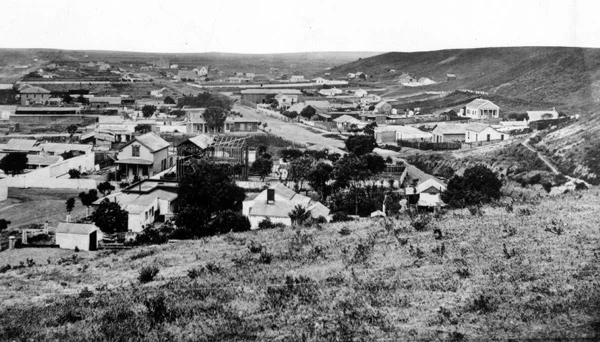
This photo is of the church not long after it is built. This area is right downtown LA off of US 101. 

Vibiana Lofts

Does it look to be in a scrubby desert? Well, LA is a dry place. Guess what? That building still stands. When the diocese was forced to move, there was an effort to save the building which worked. Then, the government got involved and made it a National Historic building. Now the site is an events center of some note. This is very analogous to what happened to the Presidio in San Francisco. 

While searching I found this site which has period photos. It is just wonderful what the web is allowing in terms of independent historical work. We want to encourage that. 

So, the site shows both the IOOF and the Swanfeldt buildings. Now, we want to look for when they were built and by whom. 

Remarks: Modified: 10/25/2023

10/17/2023 -- Following our usual mode, we went to the FB page for TGS, Inc. and posted a few words with a link to this post. It was liked by one of the regular readers. But, within about 10 minutes, there was a message of the FB post being deleted with an ominous message. Still not sure what precipitated this reaction by Meta's watcher (which one and of what variety - I would like to know specifics). Have heard of this type of thing. Have been watching over the past decade, various debacles, as technology was put into the place of people. Also, noticed that companies that cared about the clients kept people in the loop that one could talk to. This image is the message about the FB (Meta) post. 

10/18/2023 -- More on the theme: Los Angeles, again; Bunker Hill, west. 

10/25/2023 -- Earlier (or Earliest) LA. -- Why was downtown LA built so far inland? Erik Painter, on Quora.  

02/19/2024 -- Bunker Hill, the Cathedral, and such. 

Wednesday, October 18, 2023

Bunker Hill, west

TL;DR -- There are many reasons to be interested in New Spain and New England. Too, CalState has examples of research. We have seen such elsewhere. An example was Berkeleyites looking into the jaunts, early on, of Jedediah Strong Smith. More coming.  

--

There are plenty of sites with the name, no doubt. But, our focus is Los Angeles (LA), in the great State of California. We have mentioned Los Angeles, several times, and will continue to do so. There are many reasons for this interest, some of them personal. But, New England influence was there early on. And, the site is rich for providing information related to following the 250 years of the U.S. and its development. 
L.A., 1869 
from Rediscovering Downtown L.A.'s 
Lost Neighborhood of Bunker Hill
(see red circle in the
map of the next photo)

So, LA has hills. This photo was taken in the area of First and Broadway in 1869. Bunker Hill is mentioned in the caption. Some say that the hill was named because there was a Fort nearby. A 1849 document mentions the name. About the time of this photo, a developer brought the name as  a remembrance of the battle of the Revolution, in the Boston area. The 1849 document was in Spanish, the language of New Spain. The developer was from the east. 

Note: This event was covered in each issue of The Massachusetts Magazine - Regimental History Series, background and motivation. 

As we mentioned, our early interest was New England cousins who established regular coach traffic in the 1850s between St. Louis, MO and San Francisco, CA via El Paso, TX and Tucson, AZ and LA. We looked at the site of Butterfield's operation which was the Mirror building which became the home of the L.A. Times for whom John worked back in the early '60s. 

Below, we show an area near the LA City Hall which has quite a history itself. The photo looks along Temple Street from Main. It was circa 1884. Then, we have two snaps of Google shots in the area. Why do this? Places have history. Technology will be very useful in helping us preseve history, especially through the use of older photos from which people can determine landmarks. 

Perish a thought? Technology now involves AIn't (search in this blog and see our comments which are very much on solid foundations - pun intended). So, in the future, we will have to decide whether some set of old photos is of the "fakery" that has been the main output of supposed sophisticiated technology over the past year. Thanks, young guys (mainly). 

Okay, I put this together. The Hill will be up slope shown here. Ignoring particulars, for now, close to this intersection is where the Cathedral of St.Vibiana was for a long while. The Cathedral is now up on the top of this hill with the name of the Cathedral of our Lady of the Angels. Vibiana is an event center. 

Heading up the hill along Temple from
Main to the
Cathedral of our Lady of the Angels 

The circle for City Hall needs to move
to the left two streets. It is between
Spring (where the entry is) and
Main. And, in the middle of the area
from 1st to Temple.  
.  
Okay, we started this thread yesterday with a post showing the early Cathedral in the scrubbed desert that is LA. It got deleted. So, here is something for credence. 

I found this page at the site of California State, Long Beach which has the title: A visit to Old Los Angeles. It has a collection of wonderful photos over the years. For me, I want to gather and document the middle period which would be from the start of New England's influence as New Spain's grasp was loosened up until after WWI. 

The developer mentioned above was Prudent Beaudry. We will look further into his work. 

Note: New France - Prudent Beaudry. Interesting. Lots of those coming into the area were from New England. We use the term to cover the northern and southern origins, loosely.  

Incidently, John has personal reasons to do this research. Ann had family involved with early development both in L.A. and the San Francisco areas, including a great-grandfather who went west to see San Francisco in the heyday of the mania of gold. 

Now, the mania? Seems to be technology gone wild like some kids like to do at spring break. 

Remarks: Modified: 04/08/2024

02/04/2024 -- Wikipedia page on Bunker Hill, Los Angeles. 

02/09/2024 -- Used this at a FB New England Historic and Genealogical group's photo. 

02/19/2024 -- Bunker Hill, the Cathedral, and such. 
04/08/2024 -- Put comment about City Hall's location. The circle points to the label for the Park. The building itself borders on Spring on its front and Main on its rear. And, it's nestled between Temple and 1st Streets. 

Wednesday, May 1, 2024

Old L.A. and the U.S.

TL;DR -- We continue to look at CA via two cities in order to learn more about the Spanish period that preceded the entry of New England's influence into the area. Period photos are the enabling technology. 

--

We have been looking at two CA cities, LA and SF. Early on, we had Jedediah Strong Smith representing the eastern culture in his wanderings across that country. He was there in the 1830s. Later, we looked at the Butterfield Express which brought people, goods and mail from St. Louis, MO and from points in between, such as TX and AZ, to LA and onward to SF. This was in the 1850s and was quite successful despite the arduous nature of the trip. However, the Civil War interrupted the business for a few years, but post that conflict things boomed again. 

There were several motivations for looking at this area of the country which include the early explorations when it was a territory of Spain, then the initial comings and goings by sea and land, the acceleration of the New England influence after the Civil War, and, in particular, an area of DTLA that was known as Bunker Hill. As we have mentioned, it now is full of sky scrapers (high-rise corner), but the area represents changes that were fast and furious over the years. However, a huge change was the introduction of the railroad across the country. We can read of this: Samuel Clemens took the trip by stage coach; later, R. W. Emerson took a similar trip by rail. Clemens disliked the journey so much that he returned to the east coast by sea which was no mean feat either.  

W e have mentioned, before, the Cathedral (St. Vibiana's) that moved from the base of Bunker Hill to being on top in the latter part of the 1900s as urban renewal took its toll. The older building still stands, near the LA City Hall and serves the function of an event center. Today, we saw an early photo which was from before the time that the Cathedral was built. It is a smaller Catholic church with an interesting history with respect to our continuing studies of the other colonial experiences in the founding of the U.S.  

Before going further, let's pause to recognize and honor the work of the Water and Power Associates (WPA) which has collected photos related to the history of Los Angeles. This is their mission statement: 

to inform and educate its memberrs, public officials, and the general public on critical water and energy issues affecting the citizens of Los Angeles, Southern California and the State of California.

The below photos and information are courtesy of their virtual museum and collection of period photos. 

---

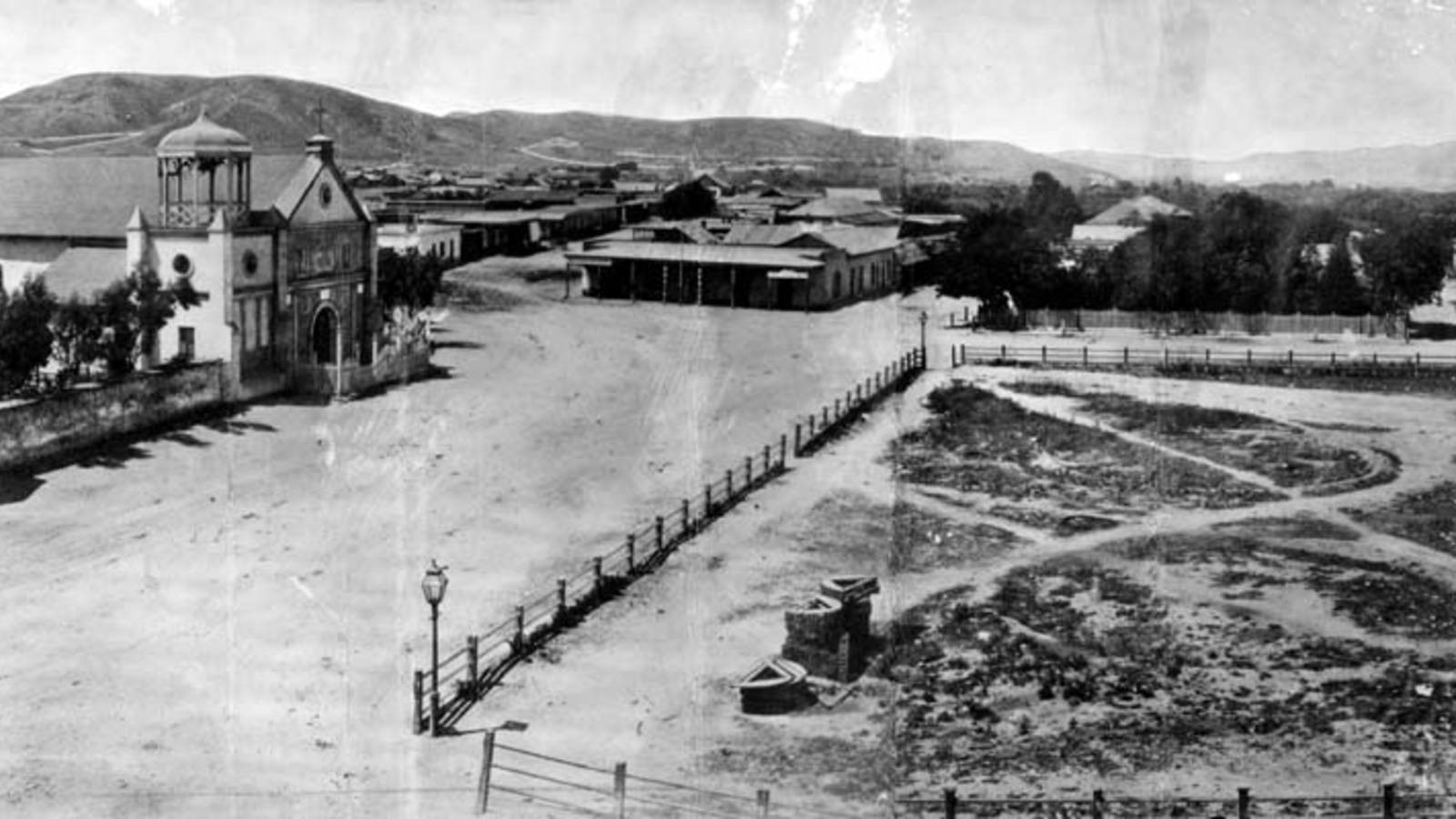
We start by looking at an earlier church (La Iglesia de Nuestra Señora la Reina de los Ángeles - Wikipedia). It is on the left of this photo that looks north on the Calle Principal which is now Main Street (Wikipedia) and which has been mentioned many times. We can consider the area to be at the foot of hills to the west of DTLA such as Bunker Hill. 

Old Plaza Church 

Zanja Madre
The caption for the photo at the WPA site mentions the "Mother Trench" (Wikipedia) with this caption:

The "Old Plaza Church" facing the Plaza, 1869. The brick reservoir in the middle of the Plaza was the original terminus of the Zanja Madre.

As mentioned, LA is a very dry place. So, water was brought in early and has continued to be of concern as the population abounded, and still abounds, almost without bounds. 

But, in the beginning: 

The Pueblo de Los Angeles was an official settlement of Spain. They had three types of settlements in Alta California: presidio (military), mission (religious) and pueblo (civil). The pueblos would provide the commercial and agricultural needs of the military as an alternative to the missions. (source Wikipedia) 

When researching Jedediah's experiences, we looked briefly at the military aspect of the community. The Old Plaza Church and St. Vibiana's are examples of the religious. In some of the early photos that we show below there were other churches appearing as New England's influence grew. But, for now, let's look at travel and trade, again. Butterfield is mentioned in one of these photos. 

Old Plaza Church
and the LA City Hall

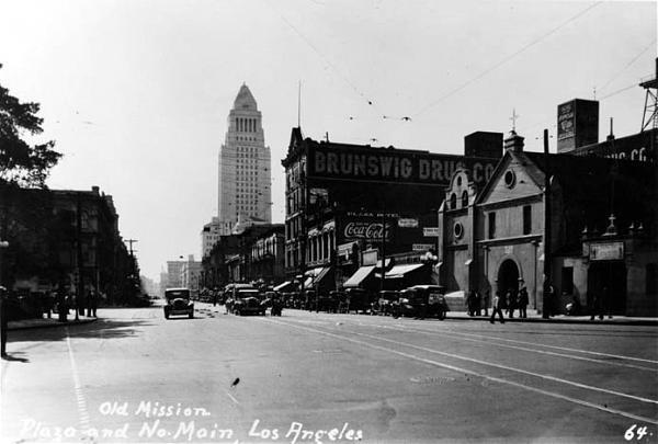
In our earlier look, we mentioned how his coaches came into the area where the Times-Mirror building is now. Let's use a photo of Main Street looking south to set the dimensions. The photo is from 1928 which was not long after City Hall was finished. We see that the civic building is just down the street from the church. 

And, the facilities used by Butterfield (and his cohorts) would have been just on the other side of the City Hall from the church. 

Quoting the WPA site: 

The Overland Mail Company operated by John Butterfield (the founder of American Express) rented space for a station until it built new quarters in 1860 at Second and Spring--the present location of Mirror Building. The Wells, Fargo and Company also had their office here and Phineas Banning (Wikipedia) operated coaches to Wilmington and San Bernardino from the hotel.

But, that brings up another view to consider. We will be looking more at the history of Bunker Hill, eventually. It is just south of Fort Moore Hill which is in the background of the church in this photo. From this perspective, one can see why there was an effort to tunnel through these hills to go west. 

Fort Moore Hill to 
the west of the 
Old Plaza Church

The PWA site on Fort Moore hill: 

Fort Hill (also known as Fort Moore Hill) was a prominent hill overlooking the pueblo of Los Angeles. Its commanding view of the city made it a strategic location.

Fort Moore was an historic U.S. Military Fort during the Mexican–American War. Its approximate location was at what is now the Hollywood Freeway near the intersection of North Hill Street and West Cesar Chavez Avenue, downtown. The hill on which it was built became known as Fort Moore Hill, most of which was removed in 1949 for construction of the freeway. The hill was located one block north of Temple Street and a short distance south of present day Cesar Chavez Avenue, between the Los Angeles Civic Center and Chinatown.

The fort is now memorialized by the Fort Moore Pioneer Memorial, 451 North Hill Street.

----

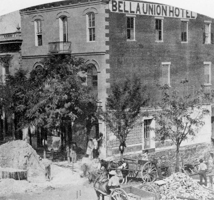
Now, getting back to Butterfield, the building where he started was built in 1835. That is very early as the area was still under Spanish control. This next photo is from 1865 and shows the state of the building after additional floors were constructed. 

1865 view after
addition to 1835 building of
Isaac Williams (Wikipedia)

Quoting the PWA site: 

The Bella Union Hotel was considered the first hotel in Los Angeles. It became the Clarenden in 1873 and the St. Charles in 1875.

Constructed in 1835 as the home of Isaac Williams, a New England merchant who moved to Los Angeles three years earlier, the one story adobe became the last capitol of Alta California during the Mexican era when Governor Pio Pico purchased it for his office.

After the conquest of Los Angeles by American forces in 1847, the building was used by Lt. Archibald Gillespie, who commanded the occupying forces. Later it housed American troops, and after they left, it became a saloon. By early 1850, the building was operating as the Bella Union Hotel. Later that year, it became the county's first courthouse and beginning in 1858, it was the region's transportation hub. The Overland Mail Company operated by John Butterfield (the founder of American Express) rented space for a station until it built new quarters in 1860 at Second and Spring--the present location of Mirror Building. The Wells, Fargo and Company also had their office here and Phineas Banning operated coaches to Wilmington and San Bernardino from the hotel. 

Wikipedia quote: 

On October 7, 1858, the first Butterfield Overland Mail stagecoach from the East, arrived 21 days after leaving St. Louis, Missouri. "Warren Hall was the driver, and Waterman Ormsby, a reporter, the only through passenger. In that era it was the region's transportation hub: Wells, Fargo & Co. and Phineas Banning's coaches to and from Wilmington and San Bernardino had offices there.

By way of comparison, the Sante Fe trail went from Independence, MO through Fort Larned, KS on its way to NM after passing through Gardner, KS. That trek, western MO to western KS took three weeks of hard work, daily. The coach trip took the same. Mostly, the horses did the work. However, think of the difficulties of the trip compared to our modern times and its highways. 

Isaac Williams is an example of the multifaceted gents who were into fur searching, trading and then ranching. Earlier, we looked at William S. Bent, New Englander, and his adventures in the middle of the country; he was a cohort of Kit Carson and others. Williams was close to the same time and followed Jedediah Strong Smith out through the Mojave Desert to the lower coast.  

Connection: One owner was Obed Macy (WikiTree) who was a Thomas Gardner descendant of a Nantucket Island family. 

---

Let's do one more photo as the three-story building that started as the Bella Union Hotel (Wikipedia) and became the St. Charles Hotel was there for a long while. And, it has a storied history that needs some attention. We will look more closely. The Daily Mirror sent an artist to visit the St. Charles and published a sketch March 16, 1936. It was demolished in 1940. 

As well, we will look at Bunker Hill houses and other buildings and identify those built by New England families. There are many photos to browse through which show the houses to be quite demonstrative of culture and money, considering the problems of LA and obtaining building materials. In one case, a mansion was converted to an apartment hotel and operated for years. 


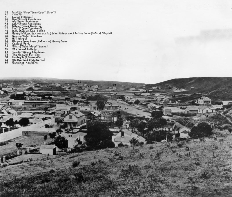
Labeled photo, 1869

This photo is from one end of Bunker Hill which sweeps around to the right. It mentions the Times building and the "old" Overland Stage Corral. The Civil War interrupted the flow of traffic. This was several years after that conflict. Notice that the 3rd Street dig for the tunnel had already started. 

---

So, as grounding or control, here is a modern view of the Bunker Hill area and its surroundings from Kenneth Hahn State Park (Times article). 


May human curators reign for a long while. Thank you, Power and Water Associates. 

Remarks: Modified: 12/23/2025

12/23/2025 -- More on the Butterfield stage as representing the U.S. government's concern for handling Overland Mail. There has been lots of research about the trail from St. Louis MO to San Francisco CA. 

Monday, February 19, 2024

US, examples, LA

TL;DR -- Los Angeles is interesting in so many ways. This post pulls some thoughts about what is known as Bunker Hill West which is in the heart of the downtown area that many do not remember. 

--

This is another of the posts about Bunker Hill west which included a few, such as New England, in LA. As mentioned earlier, the first of these was motivated by looking at Butterfield and his relationship with the Mirror Company. The Los Angeles Times was a product of a later version of this company. Their building was emptied when the LA Times ran up north to be valley people. Now, its fate is being discussed. 

Luckily, the LA City Hall and some of the associated buildings are still there. We show a photo comparing to eras below. First though, near where the City Hall is now there was a Cathedral (St Vibiana) which was moved. As a reference, there was a post (Lost Angeles, again) that contained this real early photo of the area.  

St. Vibiana, 1885 

The area of the old cathedral and the city hall might be considered as at the eastern foot of Bunker Hill (west). US 101 runs right by there. Too, the whole area was rearranged a few decades ago. One result was the Dodger Stadium was built. Skid row was move several blocks over to the east toward the railroad. Fortunately, the old LA Train Station was spared. 

The story is well documented. What we have coming to fore are photos from people that can help us preserve the history. Case in point, the following image shows two photo from about the same location. One is from the 1950s and shows the LA City Hall in all of its glory. 

Two views of 
Bunker Hill West from 
the northwest

The later, bottom view is more recent. Some of the buildings are the same. But, the City Hall is now obstructed in the view, except for its tip. The low, flat building in the foreground? That is where the St. Viviana Cathedral was moved to. We will get back to the architecture and positioning. But, it is right at the corner of US101 and I110. Pan around to the right, and one will see the Cathedral of the Lady of the Angels. Too, the high rises of Bunker Hill will come into view. 

A prior post had this photo, which includes the LA City Hall, taken from the southeast. 


Those building are an island of high-rise in a sea of extended development that turned into the sprawl of LA. We have this photo for that, too, that bears some discussion. LA's downtown and Bunker Hill West is visible on the upper right.  


This view shows I110 pacing through the sprawl from its interchange with I105. 

Remarks: Modified: 02/19/2024

02/19/2024 --  

Monday, April 8, 2024

Settlements, temporary and otherwise

TL;DR -- We continue a theme but will branch out to fill in the middle of the marvelous country started 250 years ago or so but which actually goes back 400 or so. Let's prepare to dampen the bad influences of technology. 

--

In our look at the expansion west, we have targeted a few cities in order to have a closer look. At the 250th comes closer, we will add in a few more from the vast middle. 

Continuing with the west coast theme, this view from about 1945 shows an aerial view of the LA City Hall from the west where the camera is positioned over part of Bunker Hill West. And, the view shows the buildings over a wide area that disappeared in order for the high-rise offices to dot the skyline. We can identify the families who are associated with the houses as we go along in our research. 

LA City Hall, ca 1945
Photo, courtesy of
the Los Angeles Public Library

There are many reasons for our interest in the development of this area one of which is the long history of the U.S. Development of the west started after the Revolution (250th coming up) and accelerated within a few decades. Thankfully, photography came along to capture history in the making. 


High rise corner

In this photo, one cannot see the Mirror Building nor St. Vibiana's. But, that area to the right was where the supporting work for the Butterfield Stage Line occurred. Stage coaches stopped by on their way to San Francisco from Texas and back the other way. 

Warning: Technology now stands to be more untruthful than not. Unfortunately, this is not hyperbole. 

Comparative shadows

Hence, we need to establish some provenance in terms of more than photos or other artifacts. What does that mean? Well, to be discussed. Wikipedia has a page on Main Street, LA which is an example of what can be done. 


Remarks: Modified: 04/07/2024

04/07/2024 --  


Friday, September 27, 2024

Past and present

TL;DR -- The 250th of the U.S. will allow lots of research to get some air, as the attention goes to the history of the country. We will follow that thread several ways, including a deep look at technology of computing with respect all aspects that we know, to date. We can compare different areas. One of these one-up looks will be NYC and LA, in order by age. LA is comparatively a youngster. The dynamisms of the two difer quit a bit, too. 

--

Some locations kept good records via photographs of their change through time. At the same time, we have temporal issues such as Los Angeles being younger than New York City. Then we have technology bringing in abilities that can be pinpointed in time. For instance, we know that Gardner, the photographer, was active during the Civil War. We posted several photos from his era, including one from Lawrence, KS. We called the post with the photo "Frontier century" (April 2021); its themes were several: the great expansion in the middle after the revolution (deed done primarily by the 5th generation); families being lost in time as they escaped the heavy hand of documentation; and modern efforts at recovering evidence of their existence). 

We will continue to focus on the middle of the country but have, of late, been looking at Los Angeles and its Bunker Hill (west, we call it) that mainly appeared in the late 1800s and went away a century later to be replaced by high-climbing things that cast a long shadow. We have had lots of photos of the LA area and can be more intimate as we find older photos to match up with something recent. 

LA and NY City
across time

In this photo, the left side shows part of the train yard in LA at two different times. Reminder, LA was Old Spain and Mexico until the latter part of the 1830s. LA claims a start in the early 1780s which is associated with New Spain. The area settled is known, now, as Down Town LA (we'll use DTLA). A church built in the area in 1784 later burned. At that site, the Old Plaza Church (still standing) was built built in 1814.  

On the right of the photo, we have snaps of NYC's Manhattan starting with a photo from 1876. This an old area and was part of the colonies prior to the U.S. Revolution. With the 250th of that event coming up, we will have time to cover stories about all areas of the U.S. 

One of our themes will deal with the long reach (Mirror building; Settlements, temporary and otherwise; NEHGS events) of New England. There will be others, such as technology. 

Before moving on, we know that NY City has tall builidngs. Lots of them. The tallest now is the One World Trade Center at almost 1,800 feet. Wikipedia has a list of buildings taller than 600 feet (110 buildings). 

In DTLA, the tallest building is only 1,100 feet). The LA City Hall is 454 feet (it's shown on the left in photo) and is the 42nd largest building. The smallest (53rd in the Wikipedia list) stands at 352 feet. 

We mentioned Bunker Hill west. It got its name, of course, from the site of a Revolutionary battle. We will be looking more at that area in DTLA as it represents changes over time, as influx of population changes the dynamics of a location. With a great collection of photos from different periods, we find people taking photos from that same area and focus of direction. 

Related to Bunker Hill west is this one that show 101 early on and then later. In the meantime, St. Vibiana's was closed as a church (became an event's center) and moved up the hill from Main Street to the summit. Parts of that area had been lowered early. Houses and dirt were taken away to have proper foundation for buildings. One story to look at is the Central Library which experienced two fires by arson. During the time of recovery, maneuverings got the building limit raised from that related to the height of the City Center. So, the first one went up to cast a shadow over the library. The library sold its "air rights" as one means to fund getting back to its work. They had to replace $Ms in burnt books, for instance. 

LA Central Libray with its
"twin" (to the right)
U.S. Bank Tower

On the list of tallest, the "library tower" now is #2. 

Reminder: with respect to photos (such as we see from Water and Power Associates of CA), provenance needs to have special attention, always. How all of this influence from Gen AI plays out will be a thing to watch. The ease with which fakes can be generated will make the problems more diffficult to resolve, albeit there are known ways to attempt to obtain stable and safe environments. Technology will provide the means many times for its managment; a key choice concerns human involvement. Yes, we humans can handle the complexity. Unfortunately, we could have known more; that is to be discussed.  

Remarks: Modified: 09/27/2024

09/27/2024 --  

Tuesday, June 4, 2024

NEHGS Events

TL;DR -- We like the NEHGS which has been there since the 1830s and had many illustrious members, such John Quincy Adams. So, NE is in its name. But, it has been extending its reach. Okay, we like that. Let's compare notes. 

-- 

This post looks at several events so as to tie together what might be disparate research but really is cohesive, or will be in the longer run. We have noticed ads about the types of events events offered by the NEHGS from time to time. Some have raised thought of joining. Have not yet. But, we have attended several meetings of various groups of the  Hereditary Society Community which meet in the spring in D.C. 

Now, the recent three events scheduled by the NEHGS shown here are very much appealing. For one thing, we have had lots of posts mentioning both Northern and Southern California. Both of us have lived in the State and have family in the area. The history of both of these areas shows lots of New England influence. There is more on that later in the post. 

The NEHGS meetings in CA will be in Oakland (June 8th) and Los Angeles (June 9th) this weekend. The LA event will be held in San Marino. That specific reference is necessary due to the sprawl of LA. 

NEHGS in CA 

NEHGS has been slowly expanding its reach out of New England over the past decade or so. This is reflected in their databases. For instance, it was nice to see information brought forth on Virginia and the Northwest (which is really the mid-west). Now, with CA on the radar, we can expect to see more focus on the large interior that was covered in the frontier century. 

The reality is more than the flyover country that became popular, recently, brought by the technology of aircraft. In the areas between the coasts, we deal with real people. But, just as that theme comes up, we see that the NEHGS has found one of the libraries in the interior. 

Independence, MO

In August of this year, they'll be in MO where the trails came through the trails came through. The library has been a great assest to the region where, btw, Harry S. Truman's Presidential Library can be found as well as other historical notions that ought to be remembered. 

Like, across the Missouri River in KS is where we find that John Brown caused some turmoil. Kansas was a Massachusetts which can be seen in Lawrence. John had supporters in New England. Thomas W. Higginson wrote of his visit to the area before the Civil War. 

-----

Let's get back to LA and defer more discussion to a later time about CA and SF. A recent post continued our look at Bunker Hill West (US History, details) we brought up the theme of details of someone's existence that is not related to the paper chase of genealogy. We will continue on that theme as it relates to our interest in technology and how it's being abused of late. 

But, technology is great, as well. Let's just use good old curated publishing as an example. Lots of the research to date has been looking at things known personally. Like, John lived in the Bunker Hill area for a while as a young worker. Given the work of the TGS, Inc. which has a focus on Essex County, for one thing, we have followed families as they went west. Too, the influence of New England is of interest and seems to have no end. 

Along that line, we can use Wikipedia's work to stop, look and listen (that's an old adage with regard to train tracks in the west - out where signs may be minimal). 

    • Downtown Los Angeles (DTLA) - this page has been seriously updated with new information since 2020 which is partly due to COVID. People were home and wanted to do something. In this case, the History section has increased significantly. We will go through this more thoroughly, but it does provide names of thsoe who were there at the time. We see missing names. Say, Butterfield who ran a stage-line from St. Louis, MO through upper TX and along the southern border (through Tucson, AZ) to LA. His stages stopped near the building that housed the LA Times for whom John worked while going to UCLA. (see post Mirror Building). Part of Butterfield's work met up in El Paso with a southern line started by someone from the Giddings family of Ipswich, MA. Like we noted, the stories are endless. 
    • El Pueblo de Los Angeles - several buildings exist from the New Spain era. La Iglesia de Nuestra Señora la Reina de los Ángeles is an example. We had a post about the area with LA City Hall in view in one of the photos (see post Old LA and the U.S.. One can also see the City Hall (which was remarkable for its time and was the limit for buildings - the high-rise phenomenon came about when that was repealed) is also visible from Olvera Street
    • Bunker Hill (we added the "west") as it's named for the Boston landmark and cultural icon of the U.S.) - fortunately, photos exist that were taken at various times throughout the history. Now, the southern part of the Hill is high-rise laden. The Hill itself was scarfed several times but seriously so in the 1970s to make way for the skyline makers. Yet, there were elegant and quite remarkable buildings in the area. At least, the Angels Flight rail was saved through a dismantle, store during reconstruction, and then put back into place. 
    • St. Vibiana - this was an early Cathedral whose building from the 1870s still stands. There had been some earthquake damage, but mostly it's there as an events center. There is a newer building up on the Hill (appropriately along Temple Avenue): Cathedral of Our Lady of the Angels that has remarkable architectural features and serves the role of the former building. 

This post looked at NEHGS's work and then pulled the focus to LA specifics. We'll do the same for San Francisco, later. When we do that, the original look will be at the Presidio which is of New Spain. 

Remarks: Modified: 06/04/2024

06/04/2024 --

Sunday, June 22, 2025

Bunker Hill, II

TL;DR -- The Siege of Boston continues until March of next year. This past week, there was an effort by the British to dislodge the patriots (or provincials as known in London) which didn't work. We will have to look at what the next nine months entailed for both sides, in MA and elsewhere. Speaking of which, "Bunker Hill" has been used a lot in naming over the 250 years. We compare the MA one with that area in DTLA with the name, again. But, will look at some others, ,worldwide. 

--

Right now, we are in the period that was associated with the Battle of Bunker Hill with a main skirmish happening on 17 Jun 1775 with the first piece of the action happening at the locale of Lexington & Concord in Apr of 1775. Bunker Hill Day is a regular holiday in Boston on Jun 17th. 

At this time, in 1775, the British were still surrounded. The Siege of Boston continued. The next day of commeration will be the Evacuation of Boston that happened on 17 Mar 1776. 

As we mentioned, the Massachusetts Magazine had an article on the troops that participated in this Siege with some information about the officers. There was an article in every issue, 1911 to 1918. 

And so, we will look at events and people over the coming years as the 250th lookback unfolds. 

----

May we change gears? Bunker Hill is a little over 100 feet high and is in the Charlestown neighborhood. There is a monument for the event on Breed's Hill which has a lower elevation and where most of the activity took place.

At the time of the Battle, the British owned the waters as Boston was across the Charles River from where the Battle took place. The whole affair is quite strongly resident in the American mind. In fact, Bunker Hill has been used as a name in many places. We will look again at Bunker Hill West which is in Los Angeles and about which we have had several posts. Today, we look at the lay of the land. 

But first, here is a London map of the situation in 1775. 

Printed Aug 1775, London

Before transitioning to the west coast, we have to mention the last surviving veteran of the incident: Ralph Farnham (1756-1860). He is of the upper part of Massachusetts now known as Maine and is cuz as are many. We will look at him, again, as the whole of the Maine experience needs more attention partly due to the case of the southern entity, Boston, was more prevalent in historical accountings. 

---
 
Now, Bunker Hill West? The name has been used in many places: the Wikipedia list. Notice that Los Angeles is on the top of the list. Our interest was first brought to the area as this is where the stage coach route from St. Louis arrived after an arduous trip down into Texas, across the souther border (wandering into Mexico), and then ending in Los Angeles. That was not the terminus, as with some refreshment of resources, the stage line then carried passengers and freight up to San Francisco. Where, the process started again on the way back to St. Louis. 

Mind you, folks, there are several things to consider: logistics (compared to the Pony Express, this was much more of an intricate maneuver; we are talking pre-Civil War however some of the western States had been defined (such as Missouri in 1820 - added along with Maine to balance the north-south  issues; in terms of Bunker Hill in DTLA (Downtown Los Angeles), though, the terrain was entirely different as we will be pointing out. 

The lowest point in DTLA was about 59 feet. The hightest was the hills to the west with Bunker Hill (BHW) topping 350 feet. DTLA is many miles from the ocean. In terms of survival, being in a sheltered, inland cove with fresh water from the mountains would be more appealing than the environment now associated with being encrusted by salty waters. 

In the latter part of last century (post the 1950s), there was an effort to knock BHW down which seems to have been successful. They flattened the basis for the high rises that rose and that are now photogenic against the background of Nature's display of mountains. 

Here is an example. I marked three things. 1) On the right, the line points to where City Hall pokes its head up proudly. This 1937 building was the limit for heights until later in the 1900s. We can be more specific. There are early photos from Bunker Hill showing the top of the spire of the City Hall. 

Now is the time to mention one other thing. In the center, the tannish (round) building behind the white (square) one was the first building to penetrate the old limit. The developers used the opportunity of the LA Library having experienced arson and selling its airspace to get funds to recover as a means to start the trend that gave us the high-rise look. 


So, speaking of the Central Library, they recovered physically and bought replacement books. But, there was another instance of arson later. To me, on any of these photos, I look for the bank building and figure out where the library is nestled (having spent many hours there; across the street; the base of the bank building is on higher ground along the elevation of BHW). 

2) and 3) These have to do with old DTLA from the time of New Spain onward. In the middle, the text says that if we jump (or fly like superman) over the buildings we would find the Old Plaza Church. Several of our posts have photos of this building from various time periods. Yes, it was there when Butterfield came in with his stage line. In terms of the beauty of DTLA, the Train Station which is a remarkable example of SoCal architecture is across the street. 

So, now we can consider another church. Not far from the Old Plaza Church and the City Hall is the structure that was St. Vibiana, a Catholic cathedral. That old building dates from the 1870s which is new from the west coast view point (reminder for those looking from the east). An earthquake caused some damage but not enough to destroy the building. It now is an event center of some note. 

The cathedral was moved to the left side of the photo where US 101 and the 10s intersect. We can figure out the lingo, but the area has been visited by tourists with many photos extant. This view shows the extent of the high-rise area. And, the larger buildings are clustered there at BHW. 

---

There are early photos (1870s) showing that people started to try to tunnel from the getgo. Several tunnels were completed with many still operational. As well, there were steps put up for people having to go up to the buildings on the BHW or over to the other side. And, the Angel Flight configuration of a rail car exploited the arrival of electrical power. Fortunately, through many periods of reconfiguration such as the scraping down the elevation, people saved the old mechanism which is now more of a tourist event rather than operational. 
 
---

What's next for looking at the namesakes of Bunker Hill? 

Remarks: Modified: 12/23/2025

12/23/2025 -- More on the Butterfield stage as representing the U.S. government's concern for handling Overland Mail. There has been lots of research about the trail from St. Louis MO to San Francisco CA.