Showing posts sorted by date for query watersheds. Sort by relevance Show all posts

Thursday, October 2, 2025

States and watersheds

TL;DR -- We have lots of themes to research. Rivers will be a constant. Today, we look at watersheds, again. Too, we consider a map showing the findings of Powell as he explored the west. American would not be the same without its rivers. 

--

We saw a map today that got our interest. Perhaps, at some point, we'll link to all of our posts that present a map as we continue our look at the history of the U.S. and its first colony of New England (mainly north) being respectful of the Native American culture as well as the incursions of New Spaiin and New France both of which left placenames in their language. 

Rivers are the focus today. We have many posts in on rivers and some on watersheds. And, we mentioned the Arkansas River in an earlier post today. Before making a few more remarks, here is a map related to the discussion. 

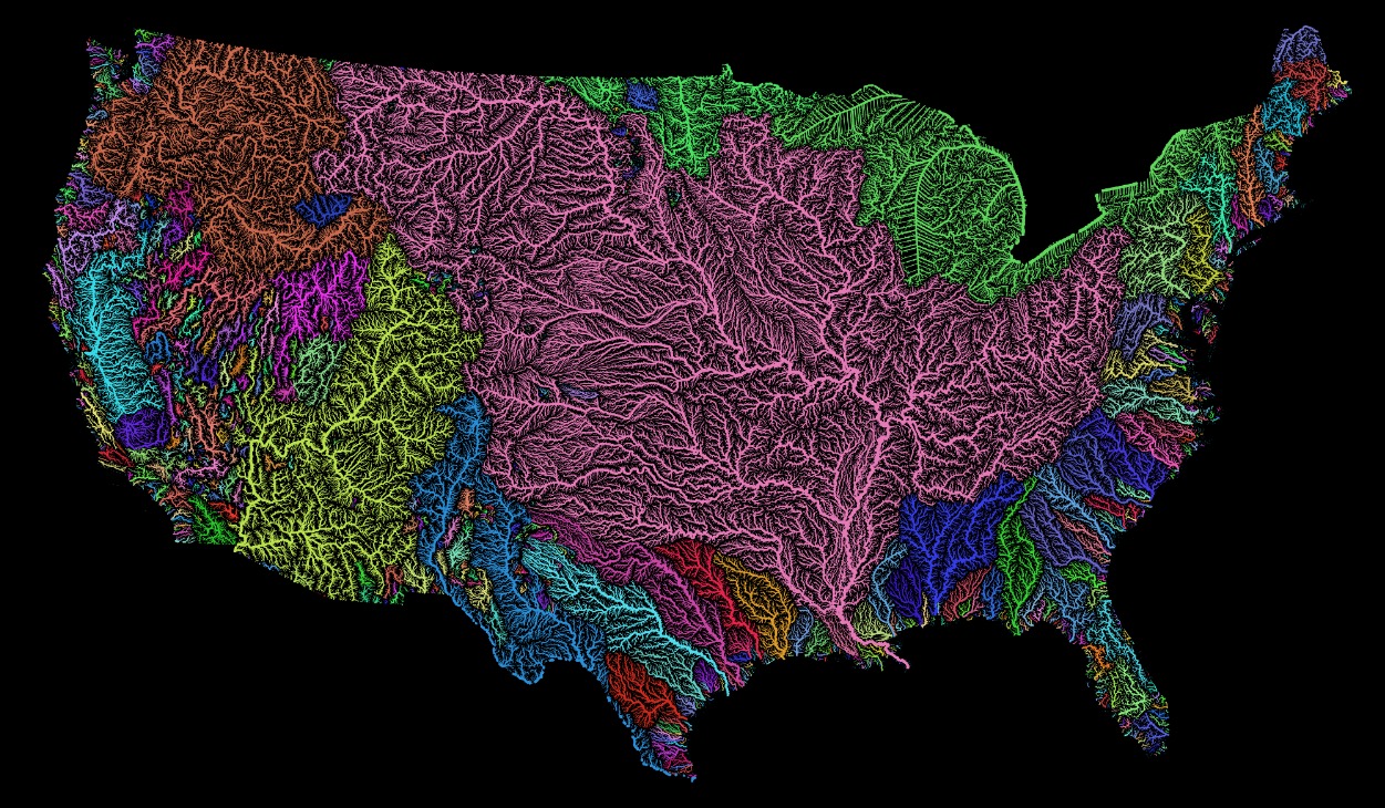
The United Watershed States of America

On the page providing this map, one can click on the map and get an enlarged view. The Arkansas River goes from Colorado, through Kansas, Oklahoma, and Arkansas before it flows into the Mississippi. It was this location where explorers out of New France (north of New York) saw artifacts from New Spain. 

It's worth mentioning that New Spain explorers were in the northern Kansas area in the middle of the 1500s. This trek was to find the cities of gold. We have a town El Dorado not far from the route taken by the Spaniards. 

Back to the map, it shows the route taken by John Wesley Powell in 1869. This was post-Civil War when the traffic to the west increased. 

Another reminder, Jedediah Strong Smith was in some of these areas in the 1820s. Having gone from New England to St. Louis, he went west and ventured into the moutains near Gardner River. He went south into the desert of Nevada and crossed the Mohave in the summer (first European to do so) ending up in LA where he was the "guest" of the Spanish Governor. Once released, he went north and east. He met his demise in Kansas at a site along the Cimarron River. 

Later, Judge Francis M. Thompson toured the area. Tour, of course, meaning on foot and horseback. Like Jedediah, he got to the left coast. On the way back, he spent time in Montana and helped the State get is legal footing. 

In all of these journeys on the land, we talked of rivers as means for transportation (Lewis & Clark) or barriers to progress. An, example might be the Lawrence, Kansas-bound group that founded the University of Kansas - they had to cross the Wakarusa having come from Massachusetts. That meant, breaking down the wagon, lowering it, getting across, raising it back up to high ground, putting it back together and then continuing. The Wakarusa was fairy tame compared to the wild western rivers that those of the Santa Fe and Oregon Trails coped with. 

We can now consider another aspect of rivers. There are many more aspects, but the watershed aspect is important. An example are the irrigation canals of the west, such as those in Utah and Idaho which supported agriculture. Of course, we learned to tame rivers for milling and transportation of goods. Our post on the Gardner mill of Salem, MA is an example of a multi-purpose mill. The canal laid out by George Washington and his crew along the Potamac is another early example. General George Washington was at the Siege of Boston and became the first President. Even Betsy made it up to see him. 

Remarks: Modified: 10/02/2025

10/02/2025 - 

Saturday, August 16, 2025

American rivers, flow

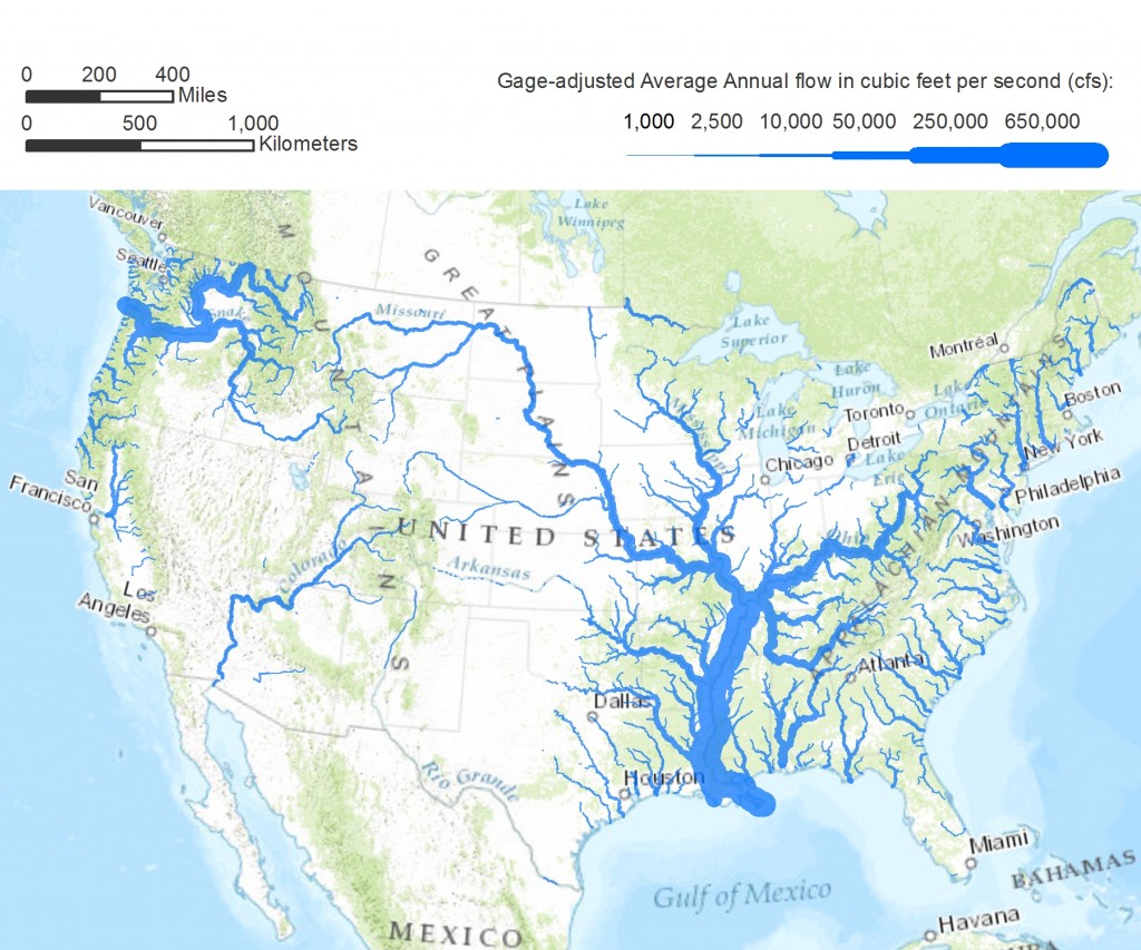
TL;DR -- We saw a graphic while browsing that was not attributed. So, we went looking and found something similar. It shows the comparative flow of the major rivers. The Ohio River stands out as does the Mississippi River which it feeds. Rivers in the southwest are drier by nature. But. they have lots of people drawing off of them. 

--

Rivers are a favorite subject. We enjoy them many ways. Some are famous. Others seem to have disappeared. An example is the Arkansas River that comes out of the Rockies of CO and crosses several US States before joining the Mississippi in AR. Along the way though, if one searches for the river it seems to have disappeared. But, the flow went underground and reemerges sufficiently to support barge traffic from Tulsa, OK to New Orleans, LA. 

On the other hand, the mighty Colorado River comes out of another part of the Rockies in CO and heads down to the Gulf of California. But, along the way, it is dammed (for Lakes) and tapped for people and crops. By the time it gets to Mexico, it is a small portion of itself. 

Those are two western examples. Looking east, the Mississippi gets a large flow from the Ohio River after it has joined with the Missouri River near St. Louis, MO. Lewis & Clark was on both. They took the Ohio down to the Mississippi, then ventured north to travel up the Missouri River, to its source. In doing so, they also looked at some of the rivers of the northwestern part of the US.

What motivated this post was seeing a graphic and looking to see its source. We show the graphic below. At the same time, we looked at some of our earlier posts as they presented graphics too. Let's list a few of these and then add in a new graphic. Each post has a graphic with respect to US rivers. 

  • Continental divides (Feb 2025) -- we think of the Divide that we cross as we travel east-west in the western part of the U.S. But, there are other divides. 
  • New Missouri (Aug 2022) -- when one compares the upper Mississippi to the Missouri, the question about naming comes up. This was really the Missouri River which contributes more water from a longer route. Whereas the flow from the north is shorter and looks larger. 
  • East meets West (Jun 2022) -- the Gardner River flooded and got our interest. It flows through what is known as Gardiner, MT. The map shows all of the watershed of the continental U.S. 
  • Research notes: Rivers (Feb 2021) -- looks at some western rivers (Yellowstone, Gardner, ...) in an area where water goes either east or west.  
  • Rivers and more (Feb 2021) -- looks at the Mississippi and one link from the west to the east via the Fox River.  
  • How great? (Feb 2023) -- looks at a couple of elevation maps of the U.S. This is to put the below material into perspective.  

We started really looking at rivers during the time of the pandemic. We were doing a lot of research which involved families who came west after the time of the U.S. start. This relates to the 250th anniversary of the birth of the Nation. Then, as we researched, more and more information became pertinent. This work precipitated our use of Frontier century and Lost generation. 

First, let's put up the graphic which shows the comparative flow of watersheds that reach a certain rate of flow. Some of these show up with a light color since the flow is reduced severely as the water makes its way out of the mountains to the shore. 

American rivers
Pacific Institute

In the middle, one sees the long reach of New England with the Ohio coming down to the Mississippi. So, stepping back, one can see the importance of the use of the Ohio in movement to the west. Wagons were brought west, moved north on the Mississippi, and then went up the Missouri. At that point, the wagons went west by land with rivers to cross. That shows rivers in two roles: means of motion; barrier to progress. We looked at the second one in our look at the New England party that left Boston and journeyed to Lawrence KS for two reasons: define a State; start a University. 

Remarks: Modified: 01/03/2026

01/03/2026 - Corrected a typo or two. 


Sunday, August 7, 2022

New Missouri

TL;DR -- Who has the longest river? Who cares? But, it's nice that these work horses get some attention beyond those worries like flooding or effects of droughts. For the U.S., these waterways were highways as well as inhibitors. Friends and foes. To be tamed. The dams of the west are an example. 

---

As in, Missouri River as the focus. Why was the Mississippi first? 

Recently, we asked, Who's on first?, with respect to the first Governor of Massachusetts and thereby a larger scope of the future U.S. Today, we were reminded that there is some issue of definitions with respect to the longest river in the world. Who cares? 
Missouri/Mississippi

The New Missouri would be consider the upper part of the Mississippi River which would really be the southern part of the Missouri. Interesting. I ask, which longest rivers flows through the most arable land? That is important for several reasons. 

But, looking at this Quora answer reminded me of some work to be done.

When I was a kid I was taught that the Mississippi-Missouri was the world's longest river (I went to school in Belgium). Now it appears to be the Nile or the Amazon. What happened?

Answer by David Gray (not recent, but apropos). 

When we were looking at rivers, we showed a map of watershed where that of the Missouri filled the whole of the center of the U.S. reaching from Pennsylvania to Idaho. 

Watersheds, U.S.

The upper Missouri area had major flooding this summer at Gardner River. We will look at that further. 

 Remarks: Modified: 08/08/2022

08/08/2022 -- Added link to Gardner River and its flooding of the Yellowstone River. 
 

Tuesday, November 10, 2020

All that Louisiana brought

TL;DR -- Jefferson bought land west of the Mississippi. It and its watersheds to the west were serious barriers to movement. Yet, people endure and overcame. This whole region is full of descendants of early New England folk. We study the families and situations in order to fill in history with a personal note. 

---

Incidentally, this continues a series related to western expansion. Efforts to move west started as soon as people were here, even before Winthrop. He arrived at Salem, didn't like it, went on to what is now Boston. This theme will be constant. Why? It honors all of those forgotten heroes (male and female) who got this country going, starting with the arrival of Thomas's crew at Cape Ann. History can look at the topmost issues; we will be looking at the nitty-gritty which is very much overlooked by many in this day of technology that entices yet offers no reality (yes, that is a focus, too, that we will touch upon). 

We have been trying to follow a few threads of families out of New England (upper right of the yellow region) to the south and to the west. As we do that, we have to consider the situational aspects with respect to culture, history and technology. The periods that we are looking at now run from the French Indian War through the Revolution and then through the War of 1812. That would be generations four, five and six. The location would be the east coast until after the Louisiana Purchase during the term of President Thomas Jefferson, the second President from the south. Before him had been President George Washington and President John Adams. 

So, we are not really paying attention to the larger picture as history has done a good job of that. We want to follow lots of families and consider the situations until, say, 1900. Or last post on this subject looked at Grizzly Adams who went from New England to California and back. Lots of people did this before Grizzly and continued to do so without cessation, even until now. One can cross the whole of the continent now within a matter of hours - without breaking laws such as speed. The record is under 28 hours. Imagine that if you were Daniel Boone who established one route. Naturally, he followed the American Indians who had been here long before. We will look at that, too. 

So, this map shows what was obtained in the deal that Jefferson did. In our posts, we have touched upon this area quite a lot. Take Kansas. Col. Higginson went there before the Civil War to help the free staters. John Brown was a friend of his. Before that, Jedediah Strong Smith was killed in Kansas. Those folks were New Englanders. About the same time, an itinerant came out of the south and was in the same area: Joseph L. Walker (1798-1876) - see the post on Grizzly Adams. 

Louisiana Purchase 

For now, let's just consider another map which was in the post on Cumberland Pass. 

The top map shows the western extent of the Mississippi's watershed. The extraordinary thing is that this was French territory and that it had been visited early. We will step back and look at that in the near future. Right now, we are focusing on the time from the exploration of Lewis & Clark that started in 1804. One thing to note is St. Louis which is in an area first explored in the 1670s. That was the period in which Thomas died. The river provided the means for movement. One thing to look at is the exploration of the rivers that feed into the Mississippi. Lewis & Clark went up the Missouri. People arrived from the east via the Ohio River. It's amazing that the eastern reach of the Mississippi is in Pennsylvania.  

Also, all of those wanderers that we have looked at so far went through St. Louis on the way to and from the left coast. Tales from the interior tell us a lot. We want to identify families and their groupings. Fortunately, lots of descendants fill the area.   

Remarks: Modified: 08/13/2021

02/15/2021 -- We are looking further at rivers as means of transportations as well as being barriers starting with the Mississippi River system. 

02/27/2021 -- Further on the western rivers (and the Missouri River). Changed to using American Indian. 

08/13/2021 -- Updates: Gloucester after Weymouth for the 400ths. The 250th of the sixth generation? SAR/DAR. 200ths: Michigan, Carving the land, Missouri and the west.