TL;DR -- New England has a long reach, as we have noted time and again. But, it also is the origin point for lots of movement that went north, south and west. We look at how names for places came about in New England. This will carry further as we review how the country filled.
--
We do this post for several reasons. One is to familiarize ourselves and our readers about New England, given the 400th is now being observed by Gloucester in MA and Portsmouth in NH. The New England Historical Society updated, recently, an article with the title of "HOW THE NEW ENGLAND STATE NAMES CAME TO BE" which had this interesting map.
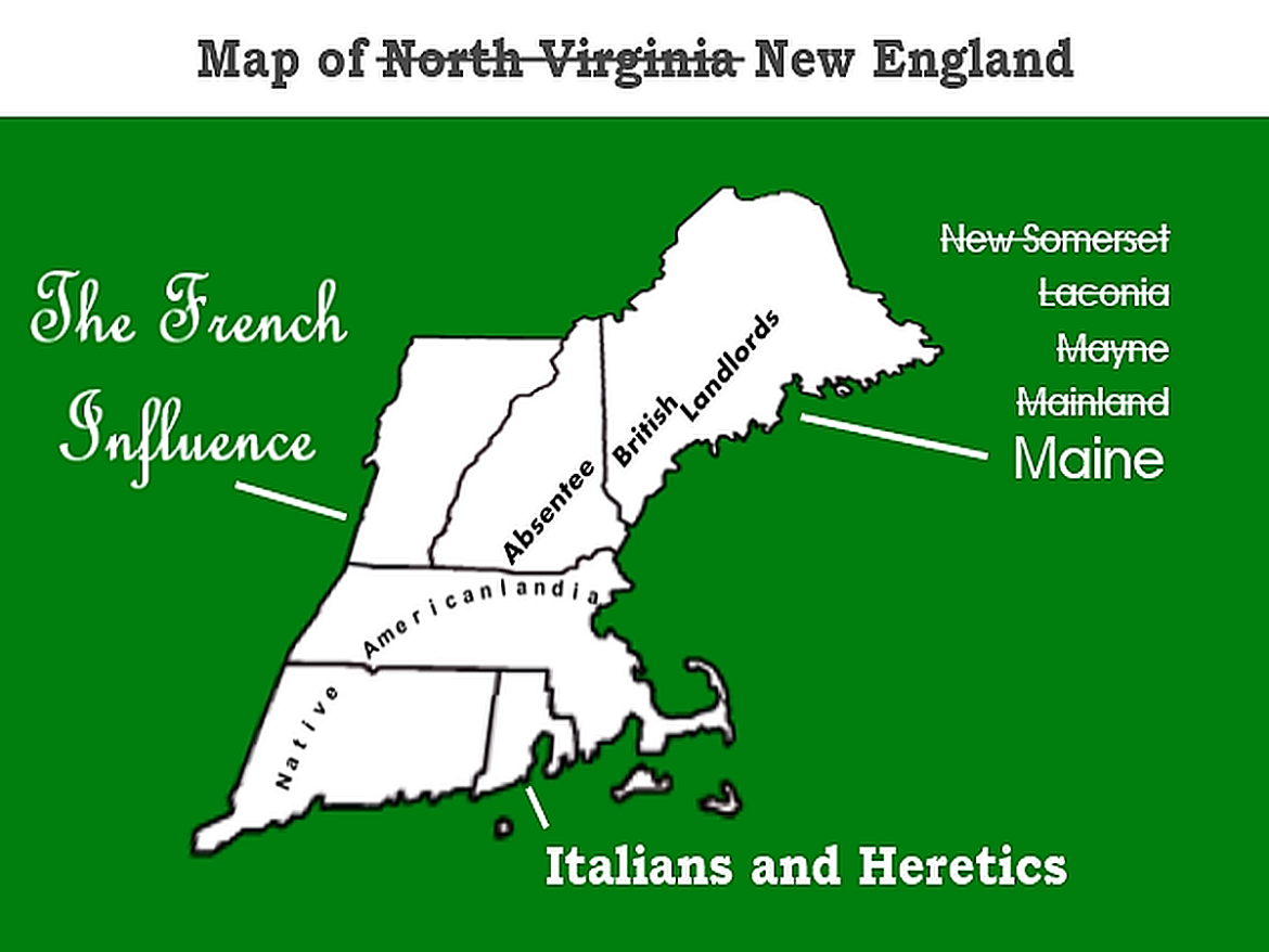
Another reason was that several names came from those used by American Indians. For Massachusetts (MA), the name refers to the Great Blue Hill whose elevation is over 600 ft. Looking at that geographic site brings up the subject of comparative heights, not only in New England but in other regions.
Let's take a look at the numbers remembering that those of the east went west. And, we know that the heights are much more in the western areas. But, what about other areas of the country, such as the South. We will also take a look at the middle parts that trekkers going west had to pass through, as the interior of the U.S. was filled?
As we proceed, we will consider the highest point in terms of mountains. For Massachusetts, this would be Mount Greylock at 3,489 ft. Looking north, Vermont's name is for the Green Mountains as they were marked on a map by Samuel de Champlain (of New France). The highest peak in that State is Mount Mansfield at 4395 ft. Before moving on to another region, New Hampshire was named for an old English county. It's highest peak is Mount Washington at 6,288.
Moving on and looking at New England south, we change a little for reasons that are apparent soon. For these States, let's list its highest point plus a prominent city to indicate the differences: Georgia 4,784', Atlanta 738'; Virginia 5,729', Charlottesville 594'; Maryland 3,360', Frederick 302'.
Virginia stands out, being the home of both Presidents Washington and Jefferson. We have done a few posts on the area and will continue as we move toward the 250th of the Revolution. The focus of the conflict moved south as time went along. Too, we mentioned the Cumberland Gap and Boone several times as we looked at the migration that picked up after the Revolution. Both Atlanta and Charlottesville are fairly high as they touch on the plateau of the Appalachians. Frederick features in the Gettysburg battle which we will get back to and was on the middle route out of the east to the west. A few posts ago, we looked a Ohio as a destination from that area and New England. A continuing theme will be the areas east of the Mississippi River.
 |
| Elevation, Kansas |
The complaint in the age of the auto is that Kansas is flat. Well, it's not. That's illusion; plus, the car is doing the work in order to allow lazy evaluations. Why say that? Expectations and interpretation are huge issues with how technology influences us. We'll get back to that theme, regularly.
But, here are the states in that area (same format as above): Kansas 4,039', Kansas City 909'; Arkansas 6,581', Little Rock 335'; Oklahoma 4,974', Oklahoma City 1,198'; Missouri 1,772', St. Louis 466'; Texas 8,751', Fort Worth 653'.
Tying back to the former list, note Texas's highest peak. That is due to the fact of it being almost beneath Denver. Kansas City is higher than St. Louis and Little Rock as it is on the Missouri which flows down to the Mississippi. Oklahoma is even higher. Forth Worth, south of Oklahoma City, is lower as it's on the route of water going to the Gulf of Mexico. Why look at this? Remember, water was either a boon or a bust. We see it now. But, then, it either helped the movement or was a hindrance. Just look around at bridges and consider traffic if they were not there. We see that from time to time as bridges collapse, through accidental damage or neglect (a topic to bring up, as well).
 |
| Click image for interactive map |
To wind things up, we look at the highest peaks in the western continental U.S. with a map. The query could be, how many are over 12,000 ft? This site has 178 rows showing that we have many over 12K and 13K and 14K. This does not include Alaska.
As we consider this overview, note the dots and then look at the trails which smartly tried to stay away from the impossible. Or, the dots aren't impressive? Consider this, the State of Nevada which has only two names on this list has over 130 mountains that are over 10,000 ft. Notice, there is no north-south Interstate highway in Nevada. The red dots had a huge influence on how this system was designed.
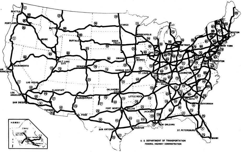 |
| The Dwight D. Eisenhower System of Interstate and Defense Highways |
The 400th commemorations and the 250th will allow us to get familiar with our country from stem to stern and left to right. Ought to be fun.
Remarks: Modified: 01/25/2023
01/25/2023 -- Added link to New France.
No comments:
Post a Comment