TL;DR -- Today we saw an old photo of a sketch which shows part of Bunker Hill West in the 1870s. That's early enough to be before lots of the changes introduced over the long span of US history. The English culture took over in 1847 from that of New Spain. And so, the area has lots of offer with respect to our interest in the long reach of New England.
--
Here we go with a post on LA, again. Yesterday, as we looked at New France and New Spain, we mentioned Bunker Hill West. In the early days, the hill overlooked bustling LA. Then, people built upon the hill. They tunneled under it to start to build on the other side. It was partly lowered starting in the 1960s. Now long after, the skyscrapers started to appear with the first one right by the Library which is about as old as the LA City Hall.
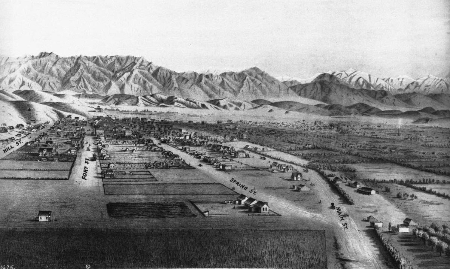
This pointer is to a search on Los Angeles within our blog. There may be Bunker Hill posts that did not come up on the list. In any case, the below photo which is courtesy of the Water and Power Organization of Los Angeles, CA is from a sketch near what is now 9th Street looking north. To orient the view, the well-known City Hall is between Spring and Main Streets (shown converging here) eight blocks north above 1st Street.
To the middle below the foothills is where one would find The Cathedral of the Angeles, not built yet. The train station is north of that.
Of interest today are the hills on the left. If one follows the Fort Street line (left of Spring Street) up toward the hills to north, there is a building standing above the city. That was Fort Moore. Going to the left, one can see parts of Bunker Hill West.
Prior posts had some information about the history of development of the hill. Today, we wanted to show a view indicating that there was a hill of size. According to Wikipedia, the elevation was up to 200 feet above Los Angeles. Naturally, there are higher hills including the massive 14k-foot mountain within a morning's drive seen on the upper right.
The Bunker Hill represents history, pre-US and post the events of 250 years ago. In this area, the culture changed several times in a manner that is representative of the changes in the US. The current stature of Bunker Hill is obvious in the photos of LA. The majority of the skyscrapers have their footing on the scraped down and leveled heights of the hill.
---
Caption of the photo: (ca. 1873)* – Panoramic sketch looking north toward downtown Los Angeles showing mostly undeveloped land. At lower-right can be seen the junction of Main and Spring streets at a point where 9th Street will one day intersect. Hill Street and Fort Street (later Broadway) are on the left. The Verdugo Hills and snow-capped San Gabriel Mountains can be seen in the distance. Photo of a lithograph, courtesy of the California Historical Society.
 |
| DTLA, 1873 |
Remarks: Modified: 10/03/2025
10/03/2025 -
No comments:
Post a Comment