Tuesday, June 29, 2021

T. E. Lawrence

TL;DR -- The 100th of WWI has people reviewing those times. This started several years ago, but the virus has had influences, for sure. Say, the Spanish  Flu was centered around 1918. One dynamic not really on the national mindset so much is Arabia as it was then. TE Lawrence is a topic of discussion in a lot of areas. To us, he represents the side of the family that stayed at home. Or, put it this way, ventured forth 300 years later. The theme to discuss? As we saw with Cape Ann and other environs as the culture moved west, we have a more recent example starting with the expansion out of St. Louis which is picked since MO was the first to be defined. The WWI timeframe? Similar thing happening in Arabia which has influences even to today. 

---

This post has several purposes. We never saw the movie that came out in the 1960s, however we were in LA at the time and remember the hoopla. Several careers were made with the movie. Which one? Lawrence of Arabia

Here's a query. Who might most people think of when they think of this movie? Peter O'Toole? If one looks at the clip and discussions, there seems to be this conflation going on which is quite understandable. We get the same thing dealing with people and genealogy. There are lots of things psychological that ought to be brought to the discussion. 

Note: John's past is partly covered in this post: Amelia Earhart. At least, there is a brief reference to places on the other side of the pond that have more problems than we see (or saw) here. It's like, there ain't nothing new under the sun. Besides, his role is keeping things steady for those who want to play the one-upman-ish game over here. No axes to grind; merely, truth engineering. 

Okay, so, who was this guy? No, not Peter, the Irish dude. BTW, his ashes were taken to the west of Ireland. That place of the wild ones. No, we're talking T. E. Lawrence. His burial was in Dorset. Though, he had been born in Wales, did the Oxford thing, Royal Army, Orientalist, and lots more. 

The timeframe? T.E. made his name in WWI with the conflict with the Turks. Seeing a few clips got the internet searches going. So, for now, here's are a few links and a comment. We'll be back to the theme. Why? We're out of the Brit culture. The past year has brought out some interesting interplays, especially with the LA scene's unfoldment. Too, we ought to have closer ties; we're family. 

  • Wikipedia overview
  • T.E. has American cousins - great thing about WikiTree is that serious genealogists hang out there, and they try to get things right. 
  • T.E. Lawrence studies - wonderful site with respect to the subject; too, the technical focus is right on - need to discuss this. 
  • Smithsonian look at T.E. - just like we have our 400th, 300th, 250th, 200th, 100th, so too do others. In terms of the 100th of WWI, we see lots of analysis. But, in terms of T.E., there is a lot of retrospective, especially since some who might have known him won't be around long. 
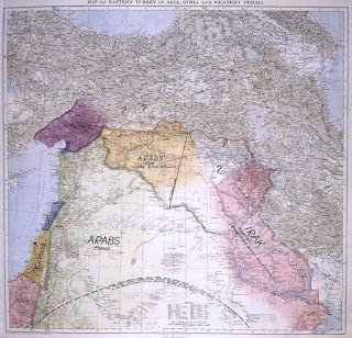
There are several ties to what we are doing. As we look at how the west was carved out, we have to look back to Cape Ann. Early on, things had to be mapped, everywhere. This takes time, The area around St. Louis is perfect to watch this sort of thing, so we'll be doing more there. Then, the Arabic world of WWI? It's a lot different than it is now. 

And, we were reintroduced to the area the past couple of decades, not that it ever went out of sight or was of not issue. Oil is one factor of many. So, let's end with a map. 

In a clip, people are talking about T.E. Did you know him? That type of thing with various recalls being verbalized. One guy passes by and says that he had a minor role in my office. Right then, the film transitions to an underground office where a shadow passes over O'Toole's (you see, mention the actor as that is not the real guy) head as a camel passes by. Peter has a map in front of him. That is one thing that T.E. did, studies with regard to the region and its people. 

Map similar to one in the movie, 
Lawrence of Arabia

Remarks: Modified: 06/30/2021

06/29/2021 --  

Pace of change

TL;DR -- Before getting into some technical issues, a pause to look at the quick coverage of the interior of the U.S. is in order. In the graphic, the blue are Post Offices (1855 and 1921) as they spread across the country. The red show the railroads (1860s and 1890s). We have looked at the time before technology came about. But, even when it did, there was a natural evolution of ability. In any case, the conflicts of today are nothing new, basically old stuff with nuances related to the current time. So 400 years ago may have been different in a lot of ways, but how close are the people then to what we had 100 years ago? 

--

This post briefly summarizes work that we done over the past few months, much of it looking at the interior of the U.S. We need to get technical, for a while, which will get us back to the issues of content management and more. This has been a periodic occurrence that has left traces (see discussion at our portal - https://TGSoc.org and our technical blog) which follow how things have changed during the past decade and one-half. Lots like to ride the wave (to nowhere). Civilization needs its moments of review in order to stay within sustainable practices. The computer has messed things up. But, also, we have new ways to research and report (that was one motivation for the Web which was based upon DARPA's attempting to have robust communications). We have to keep history in mind, local and global. Too, New England and the Cape Ann crew will continue to be of use to much analysis now and into the future. 

Messy now? Yes, but, we were messy before, too. We have been covering the frontier century, for various reasons. One of these is that we have run across lots of families who were early on the frontier and seemed to have lost their lineage. Of course, there were many newcomers during that century. However, there are others who were here whose families moved into states long before they were organized and so left little in the way of tracks.

We call it the lost generation (or two) which is the ones right after the Revolution. 

So, one might argue the Boones. Daniel's prominence made sure that people paid attention. For every Daniel, there are 100s and 1000s who get little in the way of notice. Yet, these people farmed, built, surveyed, and more. On that latter, the Bent family whose member was at the Treat signing in Kansas got us on that. The father was the organizer; the son was out in the wilds. The treaty didn't hold like many others. So, we'll be looking at that (1865, Little Arkansas Treaty - that's a river out of CO that runs through several states to the Mississippi).  

Along that line, we have pulled some images that bear discussion, especially when we consider the short period of time related to the phenomenon. In this case, it is still the filling in of the interior. We are now thinking of the land being carved up. And, Missouri is a good example being the first one. It's start is in parallel with Maine's. Look at that juxtaposition. As well, the crew coming into Essex County, MA had to get things organized including surveying. Thomas and sons helped with that. John was with the Merrimack crew. In that time, late 1830s, he did learn more than those ones at Harvard. Lots to discuss there. 

Ponder this image which comes from two sources: Paper Trails (on the left); St. Louis, MO to San Francisco, CA (on the right). The left column shows the number of Post Offices at two times (1855 and 1921). The right shows the railroads, similarly (1860s and 1890s).

The times are meant to cover a 1/2 century what was from just before the Civil War of the U.S. to around the WWI timeframe. Got that? Internal conflict was the theme of that earlier turmoil. Actually, is. How are we any different? And the latter? The U.S. on the world stage in the context of trying to resolve conflict over there which was of long running, to boot. 

Getting back to the timing of those looks, on the left, notice the heavy coverage in the east coast with the sparse dots out west. On the right, notice that the railroad may have been somewhat out to the Mississippi in the 1860s but definitely not the west. A mere three decades later, the railroad did go across the county. For the Post Offices, by 1921, they were everywhere that people were. Those huge white areas are uninhabitable. Or, folks there know that they have to go pick up their mail. 

After all, in that top-left situation, mail went west by coach (several ways), the pony express, or by water (a couple of ways). That in itself is an interesting subject that we need to keep the youngsters aware of. 

On the other hand, with respect to the railroads, that 1890s coverage was quite impressive. And, it allowed faster population of the areas. 

About internal conflict, the Civil War was no cessation. Conflict with the American Indian continued for a long time leaving a situation where the reservation mode under the guidance of Washington DC was the reality for tribes. Lots to look at there. 

In short, in one-half of a century, again, the U.S. covered an area that is huge. Folks back east with their notions of wilderness have no idea about the frontier. Genealogists, are you listening? Let's step into modern modes (beyond genetics and microbiology) a little more. 

Remarks: Modified: 06/29/2021

06/29/2021 --  

Monday, June 28, 2021

Department of Interior in MO

TL;DR -- Our focus has gone from the east coast to the middle of the country and then all coasts. The U.S. is hugely varied. And, that middle? Thought of as flyover country. Sure. Let one in the middle show you the reality that is extant there. St. Louis? Heard of it. That is the point from which the brains carved the west. Which is the middle, in this case. Over a century or more.  How relates to TGS and New England? When Missouri became a State, so too did Maine. Maine? Yes, it was grabbed by Massachusetts overlords. Albeit, that the areas were separated by New Hampshire. Oh yes, what went on in the East came out West. Same peoples, one might argue. 

--

We mentioned that we were getting back into nautical situations after looking at things that pertain to the landlubber side of the world. That doesn't mean that we won't look at the dynamics of the interior frontier. Rather, we will strike a balance. 

Now, MO is being a focus for a while due to the importance of St. Louis. Surveys were managed out of that area after the Louisiana deal was struck. It took a little time for organization to follow the people who flooded in immediately. Some of these we have looked at. 

Early records are scarce, but we can use this area to see how the west was won like the Paper Trails study did with the Post Offices across the country. As well, one repository is under the auspices of the Department of Interior's Bureau of Land Management. They have a nice database: General Land Office Records. The GLO provides auxiliary information, such as Surveys. We will look at one County out west that was not surveyed until 1819. 

We have used the GLO recently to establish some families and their footprint in early MO. But, there is another family that we can look at more thoroughly since they are well known. The Boones. Daniel was into MO before Jefferson's deal. He is not in the GLO database, but his sons are with early entries of 1825 for obtaining Patents in Callaway County which is almost to the middle of the State along the Missouri River. With respect to the Boones, we will look at Lafayette County which is getting closer to Kansas City. It is one county over from the Jackson County area of Independence that was inundated by people moving along the trails, prior to rail traffic. 

Listing for Nathan  Boone

Too, we will look at the early Missouri Compromise where Maine was split off from Massachusetts at the same time. And, how we link New England with what happened out west? Easy. Same people. We will map out those things. Like, not far from where I am, the main drag of a little town is Massachusetts Street. 

Remarks: Modified: 06/29/2021

Saturday, June 19, 2021

Shipwrighting

TL;DR -- We have had our attention on the west for a while. That is, the west that is outside of the wilderness limit of the eastern view. So, we had the northwest which is really the midwest. Then, we had that huge affair out west that became so many states. On the other side of that is the left coast and its limits. So, people went along the way via various access methods that were developed (foot, horseback, vehicles of certain types (cart, wagon, flatboat), until there was the iron horse (of course, we will get to the auto and things that fly in other than natural modes). But, stepping back, we have water, other than the river issues out west, being the major influence in the lives of lots of folks. But, prior to that, someone had to build those things. And, the first such event in the area: Maine, 1607. 

--

In considering the colonial condition that became the U.S., we have to keep in mind what people did to survive since they were no longer in their known civilized state. Coping is situation. 

For a while, we have been looking at the Frontier Century up close where we determined that St. Louis will be the focus for a whole lot of study, for several reasons. As we go forward, we need to pay attention to several areas in the west and to different players over the more than one hundred years that is of interest to one major theme. For example, one family gave us a surveyor/judge father with a trapper/trader/rancher son. 

As well, along with New England, we had New France, New Spain and others, including the American Indian. Those who coped with the immense spaces had to deal with issues related to water as well as those with land, namely waterways as obstacles as well as being modes of travel. So, rivers were (and are) an important factor. There is no end to the themes of the western U.S. (2016) to address. 

However, that which is related to the final voyage also used a whole lot of nautical metaphors, for good reason. Stepping back, we will identify parallels that exist today. Say: in the interior, harvesting wildlife almost to extinction; while on the coast, depleting forests in order to build things that float. 

This post begins that relook by taking a brief focus on ships, how they come about, and what they do. And, just like the west had its roles, shipwright comes to play on the coast when people get ambitious enough to make a vessel capable of water travel. For now, we will table those shallow bottomed things used out west. We are talking the real deal, say, the type that brought Thomas and Margaret over from the old world. 

Some shipbuilding methods

We have already have had posts with this theme. Here are a few with the year of the post: Barque (Bostonian) (2018); HMS Resolute (2021); Henry D. Gardiner (2014); Whaleship (Essex) (2015); USS Merrimack (1798) (2012); Two cousins (2012); Whaling Gardners (2011); and others. There will be more.    

For starters, here are some articles/papers that are pertinent. 

  • The Structures of English Wooden Ships: William Sutherland's Ship, Circa 1710 - this was published in The Northern Mariner (1993). There is some discussion of improvements of that time plus diagrams (pseudo-blueprints) that provide a good idea of how things are fabricated and assembled. That is, too, shows the need for raw material plus hugely talented humans. 
  • Eighteenth-century Colonial American Merchant Ship Construction - this is a thesis that comes out of Texas A&M, Anthropology. Interesting. This is a nice overview for a beginner who is a landlubber. 
  • Infant boat industry grew along the Merrimack - this is by Melissa Davenport Berry who is quite active in on-line Massachusetts history. Naturally, there are were early and later boat-building activities. Themes in this article are related to Essex County. 
  • Shipbuilding in the American colonies - of course, we have to reference Wikipedia's ways of being neutral and thorough. 
  • Maritime Commerce - this is by way of the National Park Service and is, per usual, quite informational about the ways of trade and such through those times. 

We will be looking at colonial times and a few generations later. In this sense: the fifth generation bore the brunt of the turmoil; the sixth and seventh were involved with the establishment of the new country and its modes. Of course, we still have 200 more years to cover after those folks. 

Further topics: A history of shipbuilding at Fore River; The women of Chebacco build a Meeting House, March 21, 1679. 

It goes without saying that most things that we look at come back to Essex County or Massachusetts or New England. 

We would be remiss if we did not mention the first ship building event in the U.S. (or what became such): Popham, Maine, 1607 - mentioned here, Ebenezer Gardner of Maine (2011). 

Remarks: Modified: 06/19/2021

06/19/2021 -- 

Thursday, June 17, 2021

Paper Trails

TL;DR -- The Economist reviewed a book that reported on research using Post Offices as a proxy for studying population and movement. The demo and its code for the project is at GitHub with Harvard providing the data repository. This is an example of a growing trend related to reproducibility through time and across region. We look at maps that show the early start and the frontier century. We will revisit the theme as we dive further into research which will also look at nautical world as well as influences other than New England. 

--

We have followed New England's influence starting with the nautical experiences and then getting into the frontier times in the west. St. Louis will be a center point for the earlier part of the westward movement since it was involved in carving up (see Bent post on surveyor father and his trapper son) the huge pieces that were obtained via the Louisiana Purchase and later acquisitions. But, there was movement inward from the left coast, too, as well as from the south (giving us Texas, the great State) and its spheres. 

So, our research focus will include, then, four centers with Salem in the east (yes, we see Winthrop as a later arrival), St. Louis in the center, San Francisco out on the left coast, and somewhere in TX as a southern point. Perhaps, San Antonio. Too, rather than the esteemed heights of the historian (academic) as the focus, we are following families, especially in regard to the middle not being flyover country

The below is motivated by an article in The Economist (How the West was won). So, there is an aura (per usual, Brits, what else?) of judgment that seemed to waft from what the verbiage expressed. Okay, we like the mag, for depth of content and humor. Also, they are talking of a book, same title as the post. Here are some links related to the book and author. 

Now, with respect to GitHub, we have referenced this several times as it pertains to the work of Gardner Research and to the notions of the digital realm (for which we propose truth engineering as a necessity). Our portal (https://TGSOC.org) is a start on the long trek required. Expect the theme to continue. 

Before going further, we want to remind everyone of the Age of Colonialism. The U.S. did not run around the world competing with Europe. Rather, we had our own internal dynamics. The look at the carving of part of the hemisphere will cover that. The nautical? Ah, business on and enabled by the sea. Boston got its Brahmins. The left coast and Texas? We'll punt that to later posts. 

We did snap of Professor Blevin's graphic at dates that are pertinent to our work. We are diving, now, into the situation at the beginning of the wild west, and a little before as we recognize New France and New Spain. We want to go to about the 1850s where the middle was being used as a cultural battleground long before the Civil War. But, the graphic also includes the beginning (1792) and a couple of snaps from the 20th century. 

This page gives details about the analysis using Post Offices. The image below was created from snaps from that page. Note: the application is hosted at GitHub. 

This is only an introductory look. At the top is 1792 when the new country was getting its legs. There is a little dot out west marked by a red arrow (New Orleans? Too early; looks more like TX and too early; so stray dot?). The next row is our current interest which involves the early surveying times (1805) and the time of regular traffic via the trails (1855). The next row is our Frontier Century snap (1811-1921). Why 1811-1921? The snap was after a stop. The years are close enough for what we are doing now. After all, 1811 is one year before 1812's turmoil. 1921 is after both WWI and the Spanish Flu. Lots happened to families between that time. 

We will get more fine-grained later. Lots to discuss there. In the last row is 1990 which is interesting when compared to the 1921 snap. As one watches the graphic, dark regions become light as POs close for any number of reasons. The thing is that the highways become visible. 

Aside, Jedediah Strong Smith gets little respect for mapping out the CA Interstates ;>). He got us aware of the long reach of New England. But, too, he was around a whole lot of other folk that we have looked at and will continue to study. 

Remarks: Modified: 06/17/2021

06/17/2021 -- Added the TL;DR. 

Wednesday, June 9, 2021

State Of Missouri, 1821

TL;DR -- While researching we saw a pamphlet from the State of Missouri with respect to their history and to availability of records. The history included several maps at different times which show the carving up of Missouri Territory into counties. By the time that Missouri became became a State in 1821 there were only a few counties. Others were defined over several decades. St. Louis hosted a World's Fair in 1904 which was the theme for a Judy Garland movie. 

--

This is a brief post with a few maps which are to show just how quickly things were changing out in the west where we can use St. Louis for a focus for a while. Before jumping ahead, here are a few pointers to related information that pertains to what the first map (below) shows.  

  • Northwest Territory -- this was being defined in the early stages of the U.S. as things were being settled. By 1805, Ohio, Kentucky and Tennessee had been established. 
  • New Madrid -- indicates that New Spain was there. Too, the Louisiana Purchase covered a lot of territory; however, notice that the surrounding pieces of New Spain and unclaimed are as large. 
  • Trapper, trader, rancher -- we have mentioned several of the trappers who were early out west. William Bent is an example of a family that had already moved. His father, Silas, was involved with the continual surveying necessary during the period shown below by maps by years. 

So, we start with an overview. There were three areas still to be handled in the northwest, name Michigan, Indiana, and Mississippi. These, btw, are east of the Mississippi that sets the eastern border of the Louisiana Territory.  


The next maps are local to the central/right region dealing with the area around St. Louis. We start with a 1804 look with names from New France and New Spain. The culture there of St. Louis is as aged as is Essex County of MA, for example. All of these maps come from a little book titled Missouri's Public Domain: United States Land Sales 1818-1922. We were thumbing through a copy of this today and are happy to find it online. In several other publications, we have seen a history of the area from several sides, such as Missouri or Arkansas or other. Some of these were quite detailed. This is quite direct and oriented toward sales. 

By 1812, what Louisiana brought was under siege by newcomers. By the next year, Arkansas was under consideration as it was being carved out of New Madrid. In 1799, Boone, himself, was in the St Charles area. He was involved in the local area. There is a tale that he went up the Missouri River, as far as Yellowstone which is remarkable for someone in their 70s.

                         1804                    1812                            1813                     
 
1816
In all of those maps (1804 thru 1813), one can see the Missouri River cutting across the top. In the middle two images, it is the top boundary of the St. Louis County which extends from the Mississippi River on the east to the left border. What is there? The next map from 1816 brings in the west and the north. A Howard County picks up the Missouri and extends the northern border above which will be Iowa. 

Then, in 1821, we see the initial look of the State of Missouri. Howard is cut down in size quite severely. Boone gets a county named for him in middle of the state along the Missouri River. 

Anticipating the movement further west, the activities of the Trails which flowed through the Kansas City area will be in Ray County. That is, as we will see, lots of traffic came down the Ohio to the Mississippi and then went north to St. Louis and west on the Missouri. It was at Kansas City where the focus changed from water to the toils of laboring across the landscape. 

All along these ways, we had families seeing something they liked and staying. Or their decision was the result of any number of issues that could have arrived. The net effect is our Frontier Century

1821

With a nod to culture, St. Louis hosted a World's Fair in 1904. It's theme was the Louisiana Purchase. We have a lot more to look at with respect to the century and what it entailed. 

In 1944, there was a movie titled Meet me in St. Louis. We can look further for New England references, but one of the stars has plenty. Namely, Judy Garland (Famous Kin). 

Remarks: Modified: 06/17/2021

06/17/2021 -- Add the TL;DR. 

Monday, June 7, 2021

The Naumkeag

TL;DR -- At a Salem site dealing with the Witch House, we saw a page written by a descendant of the Naumkeag. On looking further, there was a timeline and links to additional material.  

--

The Witch House, of Salem, website caught our attention with this tag: The Naumkeag. Frankly, we are a little late with addressing on-line material related to the original inhabitants of what became Salem. Not only is there a brief history, there is a timeline. Too, some words of Sidney Perley are provided with regard to activity recorded officially. 

 
The Witch House website

Then, there is an extensive listing of reading material which we will go into further. There are references to writings of the time, such as Roger Williams and others. There are publications sampled through the past centuries up to modern material. 

We followed one of the current links -- Unraveling the Spreading Cloth of Time: Indigenous Thoughts. There is a blog which did a brief review. See River, Blood and Corn. The subject is an Indigenous people's look at Quantum Physics. That find was a great start. We will be editing our bibliography as we review this new-found material. 

Reviews: IndiginewenglandlitGoodreads, ... 

Remarks: Modified: 06/17/2021

06/17/2021 -- Added the TL;DR. 

Thursday, June 3, 2021

Western Expansion

TL;DR -- After mostly looking at coastal issues, we turned our attention to the western part of the country into which went a flow that was a mere trickle at first and then became a flood. Historians liked to use 'westward expansion' in their view from on high. We're on the ground and see a western expansion

--

We started off using "western expansion" looking at the phenomenon from the west and with a particular focus on the people involved. We used the phrase starting in 2016 to point to other posts (Jedediah Strong Smith, MH Gardner, Real Daughters). But, our first sense of the west was the lonely grave in Nebraska (Flyover country) and, later on the same theme, No brick wall

Today, we saw that many have used 'westward expansion' supposedly with this phrase due to Thomas Jefferson. However, Britannica uses 'westward movement' in their description. We like and will continue with 'western expansion' with an addition. 

It's time to map in historical information when it makes sense to do so. Each of the below links go to additional information that is pertinent. For each, we will put in a comment about the content. This list will be edited over time. We will start with Wikipedia's nice coverage of the timeline for which we will add events and their research on the trails. 

This image comes from an educational site and mentions the same routes that got our interest. There are more, again. But, this is a good start. 

Remarks: Modified: 01/07/2022

06/17/2021 -- Added the TL;DR. 

01/07/2022 -- We will use Harvard and the Boston Brahmins as the overarching thread under which reality (of people) exists. That is, lofty is without merit when metrics are involved, even those of the qualitative type. 

Wednesday, June 2, 2021

HMS Resolute

TL;DR -- Over 400 years, a lot happened. At first, there was the Crown as the dominant factor. At the 250th split, we had two interests, namely the U.S. and the U.K. Of interest was presence in the northern regions. A U.K. attempt failed. Rescue efforts failed leaving a U.K. ship abandoned which was found later by a U.S. whaling crew. The ship was returned to the U.K. Later, Queen Victoria had furniture made from its wood. A desk made from the wood of this ship is in the White House and still in use. Later, the U.S. Army tried to establish a northern site. That failed as did early rescue efforts. Later, another rescue was attempted jointly by the U.S. and the U.K. The lost team was found, after they had spent three years in the remote region. We have lots to look at in that regard. 

--

In our early years, we were trying to match up Thomas Gardner descendants. We still do that but have expanded to include Cape Ann families and Essex County finally getting to New England which has a long arm across the nation since the end of the Revolution. Prior to the events that led up to Lewis & Clark's jaunt, that west was New France's or New Spain's. New England had continual sibling conflicts with the former. Dr. Frank noted that this allowed the colonists to be trained under the auspices of the Crown in order to get their moxie to become independent. 

There might have been the Paris deal of 1783, however conflicts with those ones over there continued. We know of the War of 1812. There were other little frictions mostly involving Canada. When we read about characters in The Revenant arguing about who could be where, it was due to the borders being fluid. The Revenant? Why did this get attention? It's the time of Jedediah Strong Smith who was in the area. Too, those characters were either New England (north and south) or New France. The time was the 1820s. Of course, the mountain man was there until later, such as that Adams character (shown on TV) who was a cousin of John Quincy Adams. If you go west, note the names (mostly New England). 

Except, a pause. The American Indian's experience will feature in our work. 

So, we had the ruffians out west and the elite back east. Was that all? Well, St. Louis comes to fore. Jedediah Strong Smith was there for a bit. Lewis & Clark passed by. It was out of New France and old. A crew came down to there from the Lakes, namely east of Montreal. How? Around Green Bay, they started to travel up [stream along] the Fox River and later did a portage (a minor distance) to the Wisconsin River and then came to the Mississippi which took them south. Their tale says that when they got to where the Arkansas came into the big muddy, the American Indians had New Spain trinkets. So, turn about was the choice. Guess when that was? About the time that Thomas as an old man. 

St. Louis will feature in several themes due to its age and to the roles it plays with the west. At the same time that the mountain men were out west, we had the organizing elements coming into the area. One example is Silas Bent who did surveying for the Louisiana Purchase among other things. His son, William, was a trapper, trader, and rancher. He was at the 1865 Peace Treaty signing along the Little Arkansas River with American Indian leaders and many from New England. 

So, that introduction shows the interplay of time and region. It's a huge subject that can be filtered somewhat by concentrating on families rather than big themes/memes. Partly. An early example was Gen Adolphus Greeley (at the time, a Lt) and Captain (USN) George William Coffin. The former is a descendant of Sarah (Gardner) Balch; the latter is of Richard Gardner and Sarah Shattuck. The latter was of the crew that saved the former after he and his men were stranded in the Artic for three years with little to no equipment. The rescue attempt included U.S. and U.K. ships. 

Imagine that? Greeley's wife got the support for another attempt after there had been several with no success. Greeley's expedition had been to the areas of the Franklin Bay. At the time of that post (2011), we didn't take a further look, so this post is a continuation. 

Recently, we heard of a desk in the White House that came from a ship, the H.M.S. Resolute. It had been abandoned and found by a New Englander. Well, the H.M.S. Resolute was one of the ships used by the group that went to rescue Sir John Franklin. He and his crew had been lost. This has to do with trying to find a Northwest Passage. 

Later, Greeley was there to try to establish a base for the U.S. Army. We are talking the 1840/50s for the Franklin effort and the 1880s for Greeley. 

The ship [left by the Franklin rescue crew] was discovered by a whaling crew out of New London, CT. It had been abandoned. When found, its contents were in a pristine state, and the Captain (Budington) got it prepared to sail home [to CT]. At the time, there was some discussion about what to do [with the ship]. A decision was made to refit the ship and present it to England. The motivation was to show good will as the two countries were having family spats. 

Queen Victoria was pleased. Later, she had the ship decommissioned and broken down. There were three pieces of furniture made with this wood: the desk, a writing table, and a smaller desk.  The first went to the President at the time, Hayes. The Queen kept the writing table and gave the smaller desk to the widow of one of the crew that went to rescue Sir Franklin. 

That smaller desk was later acquired by the New Bedford MA Whaling Museum. 

The gift from Queen Victoria was received in 1880. Our relations improved, and the U.S. got great allies via the U.K. It was not long after this that the U.S. needed help to rescue the Greeley group. 

Remarks: Modified: 09/09/2021

06/03/2021 -- Pushed this to the FB Cover for TGS and used the Greeley|Coffin photo for the Profile. 

09/09/2021 -- Typo changed which was found during a quiet review. 


St. Louis MO to San Francisco CA

TL;DR -- New England has a long arm as there were two centuries along the East side prior to any attempts at expanding west. For most situations, one can find newly arrived families as well as those of various older lineages. In particular, we will focus on individuals including their business activity. A case is Butterfield who was Yankee and quite active out west. In his life, we see the impact of the Civil War. Too, we see progress via technology, such as the telegraph and the train. Butterfield did other things, but he designed a system to transport people, mail, and goods overland from St. Louis to San Francisco sweeping down through the southern regions. This was a regular activity for more than two years and deserves attention, for many reasons. 

--

The 250th of the American Revolution gives us a chance to relook at history. One thing to note is that the rebellion was the onus of the 5th Generation. Post the conflict, the 6th and the 7th were involved with the fulfillment of Manifest Destiny. Of course, we will look at that, too. But, in this context, we are looking at particular periods leading up to the 20th century whereby the U.S. slowly got its bearings. As we follow the populace, we will note the state of technology and more.  

Earlier, we mentioned the Butterfield Overland Express which went from St. Louis, MO to San Francisco, CA by swinging down south into Texas, ran across the bottom of NM and AZ (Tucson), went along the southern border to Los Angeles, and then up to San Francisco. We can do that trip easily now, all by Interstate Highways. The image shows the modern look with about 40 hours estimated for the trip. That means that drivers switching off would make the trip in two days (see map, courtesy of Google maps). 

As an aside, flying now from STL to SFO is a little over four  hours. Also, there are faster modes by air.

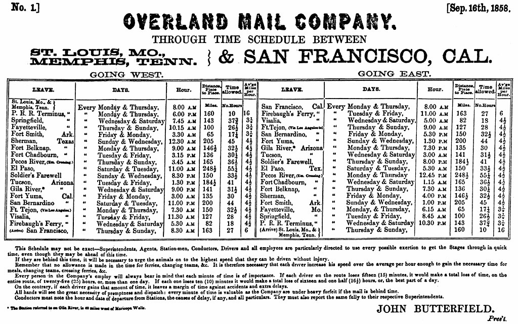
Even though part of the Butterfield route ran from 1849 until 1882 when the railroad offered a better means, the Civil War interrupted the pattern in 1861. This was a regular run by a system that employed people and animals and required equipment. The organizational work must have been mind-boggling with little communication means beyond telegraph. The Schedule for Sept 16, 1858 lays out the route, the time, and discusses some of the particulars about the company and its mission. 

On digging deeper, we found that John Warren Butterfield (WikiTree profile of John) was the owner. Too, he came from New England stock which raises our interest. The part of this route that ran from West Texas to Southern California had been established by another New Englander, George F. Giddings, of the Ipswich, MA family. 

On looking further at John, we found that he was involved with the start of American Express, too, with two other New Englanders, Henry Wells (WikiTree profile of Henry) and William George Fargo (WikiTree profile of  William). Yes, Wells and Fargo established Wells Fargo (their motif was a stagecoach with horses) in San Francisco during this period. 

As the country expanded, the need for business communication increased all around. Too, the U.S. Postmaster General had the responsibilities for mails and used companies. AmEx started in Buffalo, NY in 1850 but established itself in Manhattan, NY before too long. It's focus became financial express. 

As people spread west, there was a corresponding need for personal, as well as business, mail. And, delivery was a growing business. Another business model involved moving people with coaches. Hence, the need for the overland express. Of those available at the time, the Postmaster General decided that Butterfield's express was the most capable. 

At the time, there was a more northern route (Central Overland California and Pikes Peak Express Company) which included the Pony Express. This was the means that Mark Twain used to go west and that he wrote of later. We will look further for comparative views on this subject from those who were there. The southern route, though longer, was preferred due to less hassle related to snow issues. However, in the summer, there was the opposite as part of the route was labeled El Camino del Diablo.

The Civil War interfered with the business success of these express companies. Some of the routing was moved up north while the southern route was abandoned. Fortunately, the rail system became a little transcontinental in 1869 thereby offering an improved method for this type of express from Kansas City to San Francisco and all points between That is, there was one line running across the country. Leland Stanford led these choices. It took another couple of decades to get more rail installed. These three maps indicate the rail lines in red. The west is without rail in the 1860s. Then, we see the one line of the 1870s. Finally, see 1890s which still has lots of open space in the west. 

So, things were booming prior to the Civil War as the new nation got its legs. Then, the war was a huge disrupter across the board. It took another generation or two to recover. That, too, is part of the U.S. story. 

We think that the western stories need to be brought to attention. For the 300th, the ceremonies were mainly east coast. However, it was not long after WWI. In 1890, the largest concentration of red is in IL showing the prominence of Chicago and its access to the Lakes. The slight red around the lower Mississippi is due, in part, to the river being so useful for transportation. Notice eastern Texas as opposed to its western counterpart. Again, that is due to the flow related to the shipping industry of the Gulf. 

Reminder, we looked the Unfoldment. Notice the change of the population pattern through time. 

Remarks: Modified: 10/06/2022

06/19/2021 -- Very old St. Louis in the State of Missouri

10/06/2022 -- Have used this post in many posts, newsletters and comment. Updated the error for the URL for the post on the Gidding's route: West Texas to Southern California