TL;DR -- Further look at the Mississippi and the portage area in Wisconsin that links the Fox River with the Wisconsin River.
---
As mentioned before, rivers facilitate travel, however they are also barriers to movement. People moving west out of the east coast traversed large chunks of land as well as crossed over major rivers: All that Louisiana brought. That post looked at the Mississippi watershed which covers almost the whole of the continent, as the river came to the U.S. from the area of New France. Getting familiar with specifics reminded us that we need to look at the other colonies. There were New France, New Spain, New Netherland, and New Sweden. The last two were short-lived, albeit the effects of that effort remain visible until today. It was England, France, and Spain who continued in their conflicts for another century plus.
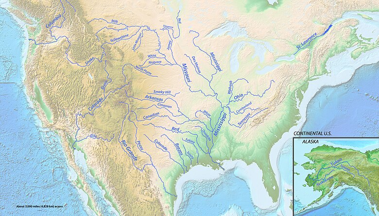
Before getting to the theme of the post, let's use a better image from Wikipedia that shows the major tributaries of the most major of the water systems in the U.S. This post deals with an area in the north central of this map (that is, to the upper right of the heavy blue line). Later, we will back up and update an earlier post about the Gardner River which is in the upper left (Yellowstone area). To be complete, we have to look at the other major systems in the west that do not drain into the Mississippi (Columbia, Rio Grande, Colorado, and few smaller systems in the west, plus Texas and its rivers - Pecos and all).
 |
| Mississippi River |
So, the theme continues to be about rivers. The Wisconsin and the Fox rivers are so close in Wisconsin (see upper center part of the above map, to the right - the Wisconsin is shown) that a portage was established way back in the 1600s (of course, known way before the Europeans arrived at the scene) that allowed travelers (their original location was the St. Lawrence area) to use the Great Lakes to get to the Fox River (via Lake Michigan) and over to the Wisconsin River so as to get to the Mississippi and venture south toward the Gulf of Mexico. That party traveled down past the Missouri River to the Arkansas River which are both carriers of water from the Rockies.
What was interesting to learn was the height differences from Lake Michigan to the Mississippi Valley plus the short distance of the portage which was less than three miles. The graphic depicts the elevation of the locks that were established to allow transportation to use the route. Prior to that, there would have been manpower in movement of the vehicle as well as other portages in order to bypass rough areas. Albeit, none of that would have been too strenuous in normal conditions, compared to what was coming for travelers as they got past the area of the plains.
 |
| Fox-Wisconsin Waterway |
 |
| Illinois Waterway |
Remarks: Modified: 11/29/2022
02/16/2021 -- Got to love Wikipedia. This post lists rivers of the U.S. by length. The Missouri tops the Mississippi by a 100+ miles. It's due to those twists and turns in the mountains of the west. Also, for each river, it shows where it drains. Note that six major rivers flow into the Mississippi. Then, each of these has many rivers flowing into it. So, the Mississippi system is huge.

No comments:
Post a Comment